The best stops on the Icefields Parkway: a complete list
How many stops should I make on the Icefields Parkway?
For a one-day drive between Lake Louise and Jasper (232 km), plan 6–8 meaningful stops: Bow Lake, Peyto Lake, Mistaya Canyon, Columbia Icefield, Tangle Creek or Stutfield Glacier, Sunwapta Falls, and Athabasca Falls. Allow 8–10 hours total. A two-day split lets you add secondary stops like Waterfowl Lakes, Parker Ridge, and Horseshoe Lake.
Highway 93 North between Lake Louise and Jasper is not really a road in the ordinary sense. It is a 232-kilometre corridor through two UNESCO World Heritage national parks, passing beneath 11 major glaciers, alongside dozens of lakes and waterfalls, and across terrain that reshapes continental-scale weather patterns. Every kilometre rewards attention. The problem for a first-time driver is the sheer density of worthwhile stops — and the real risk of arriving in Jasper having blown through viewpoints that deserved half an hour each.
This guide catalogues the best stops along the Parkway in geographic order from south to north (Lake Louise to Jasper), with distance markers, realistic time budgets, and honest assessments of which stops justify a full walk and which are fine for a five-minute photograph. Use it alongside our Icefields Parkway driving guide to plan the direction, timing, and logistics of your trip.
How to use this list
The Parkway is usually driven in 8–10 hours with meaningful stops, or split across two days with an overnight at the Glacier View Lodge near the Columbia Icefield or at a Parks Canada campground along the route. A purely scenic drive without walks can be done in 4 hours but essentially wastes the landscape.
For a one-day drive, pick 6–8 of the “essential” stops below. For two days, you can realistically hit all of the essentials and most of the secondary stops.
Distances are measured from the Icefields Parkway’s southern junction with the Trans-Canada Highway at Lake Louise. All stops are signposted from the highway.
A Parks Canada Discovery Pass is required for the entire length of the Parkway. Buy one at the park gates on the Trans-Canada or in advance. See our Parks Canada Discovery Pass guide for the full breakdown of costs and options.
The essential stops (one-day drive)
Herbert Lake (km 3)
A small, tree-fringed lake a short distance from the Parkway’s southern start. On calm mornings the surrounding peaks reflect perfectly in the still water, and it is one of the most accessible “mirror” photographs on the entire route. A five-minute stop, but a satisfying first taste of what the Parkway does repeatedly.
Time needed: 10–15 minutes Walk: Roadside pullout; no significant walking required
Crowfoot Glacier viewpoint (km 33)
The Crowfoot Glacier was named in the 19th century for its three-toed resemblance to a bird’s foot — a shape that no longer holds, because one toe has retreated high onto the mountain since the name was given. The viewpoint’s interpretive panels include historical photographs for direct comparison, making this one of the clearest illustrations of glacial retreat in the Rockies.
Time needed: 15 minutes Walk: 2-minute stroll from the parking area to the viewpoint
Bow Lake and Num-Ti-Jah Lodge (km 36)
Bow Lake is the headwaters of the Bow River and one of the genuinely extraordinary stops on the Parkway. The lake is fed directly by Bow Glacier above, and the turquoise colour produced by glacial rock flour is at its most intense here. The historic Num-Ti-Jah Lodge on the lakeshore, built in 1937 by mountain guide Jimmy Simpson, is a destination in itself — a log lodge with a red roof that has become an icon of Rockies tourism.
Walk to the lakeshore for the best views. For a longer excursion, the Bow Glacier Falls trail (7.2 km return, 150 m elevation gain) follows the lake’s north shore to the base of a spectacular hanging waterfall below the glacier — one of the best easy-to-moderate hikes directly from the Parkway.
Time needed: 30 minutes for shoreline views; 3–4 hours with the falls hike Walk: Flat lakeshore paths, or the 7.2-km falls trail
Peyto Lake viewpoint (km 77)
The most photographed viewpoint on the Parkway, and arguably the single most famous vista in the Canadian Rockies. Peyto Lake’s wolf-head-shaped basin of vivid turquoise water, set below Bow Summit (the Parkway’s highest point at 2,069 metres), appears in more tourism campaigns than any other Rockies lake.
The viewpoint is reached via a 1.3-km return paved walk from the Bow Summit parking area — gentle but uphill in places. An upper and a lower platform both give outstanding views; photographers often prefer the lower platform for less foreground vegetation. The parking area fills early in summer: arrive before 8:30 am or after 5 pm to avoid queues.
Time needed: 45–60 minutes Walk: 1.3 km return, paved with moderate slope
Mistaya Canyon (km 100)
The Mistaya River has carved a narrow slot canyon through limestone bedrock just off the Parkway. A short trail (1 km return) descends from the parking area to a footbridge crossing the canyon at its most dramatic point, where the river has sculpted sinuous potholes and walls into the rock. The water colour is a striking turquoise-green, and the force of the current produces a constant roar.
This is one of the Parkway’s most underrated stops. The walk is short, the canyon is remarkable, and crowds are modest compared to Peyto Lake or the Columbia Icefield.
Time needed: 30–45 minutes Walk: 1 km return, mostly flat with a short descent
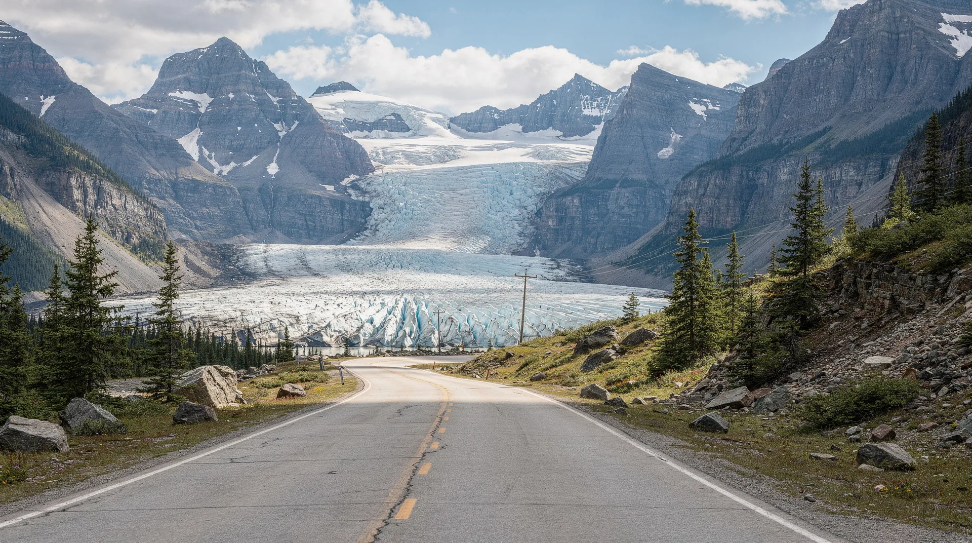
Columbia Icefield and Athabasca Glacier (km 127)
The Columbia Icefield is the largest non-polar ice mass in North America and the defining geographical feature of the entire Parkway. The Icefield Centre at its edge provides orientation, a Parks Canada interpretive area, a restaurant, and the launching point for two major activities: the Ice Explorer snowcoach tour onto the Athabasca Glacier, and the Columbia Icefield Skywalk — a glass-floored platform cantilevered 280 metres above the Sunwapta Valley.
Even without the paid tours, the Athabasca Glacier can be approached on foot along a walking path that passes recession markers showing where the glacier’s snout stood in each decade since 1840. The markers are among the most striking visual records of glacial retreat anywhere in Canada. Walking to the current glacier toe takes 30–45 minutes each way.
Book the Columbia Icefield Ice Explorer and Skywalk tourTime needed: 2–3 hours for the Icefield Centre, glacier walk, and interpretive area; add 1–2 hours for paid tours Walk: Glacier approach is 1.8 km return over uneven moraine
Tangle Creek Falls (km 134)
Seven kilometres past the Columbia Icefield, Tangle Creek Falls drops directly beside the highway in a series of tiered cascades. The falls can be viewed from a roadside pullout with essentially no walking required — a good quick stop for a stretch and a photograph after the long Columbia Icefield break.
Time needed: 10 minutes Walk: Roadside pullout
Sunwapta Falls (km 177)
The Sunwapta River bends sharply around a small forested island and drops into a narrow rocky channel in a single dramatic cascade. A short walk from the parking area reaches the upper falls viewpoint — the most photographed view. A longer trail (2.6 km return) continues to the lower falls, which drop through a wider canyon and are arguably more impressive than the upper falls, though less visited.
Time needed: 30 minutes for upper falls; 1–1.5 hours including the lower falls Walk: 5-minute flat walk to upper; 2.6 km return for lower
Athabasca Falls (km 200)
Despite being only 23 metres tall, Athabasca Falls is one of the most powerful waterfalls in the Canadian Rockies by volume, funneling the full Athabasca River through a narrow quartzite gorge. The sound and spray immediately recalibrate any assumption that a 23-metre drop is modest.
A network of paths and bridges on both sides of the gorge provides multiple viewing angles, and an abandoned channel — the “potholes” — shows where the river once flowed before carving its current route. This is the last major stop before reaching Jasper town.
Time needed: 30–45 minutes Walk: Flat paved paths across the falls area; 5–15 minutes of walking
Secondary stops (add if you have time)
Waterfowl Lakes (km 56)
Twin lakes between Peyto Lake and Mistaya Canyon, with the jagged peaks of Mount Chephren rising dramatically above the northern shore. A Parks Canada campground and picnic area occupy the south end. The lakes do not have the intense colour of Bow or Peyto but the mountain backdrop rivals anywhere on the Parkway, and the crowds are far lighter.
Time needed: 20–30 minutes
Saskatchewan River Crossing (km 120)
The crossroads village at the junction with Highway 11 (to Rocky Mountain House and central Alberta) is the Parkway’s only service stop between Lake Louise and the Columbia Icefield. A basic hotel, restaurant, and gas station operate in season. Stop here for fuel if your tank is below half — the next station is at the Columbia Icefield 50 kilometres north, and occasionally operates on limited hours.
Time needed: 15–30 minutes (service stop)
Parker Ridge trailhead (km 117)
For hikers, Parker Ridge is one of the finest short hikes on the entire Parkway — a 5.4-km return trail that climbs through switchbacks to an exposed ridge overlooking the Saskatchewan Glacier, a massive tongue of ice flowing from the Columbia Icefield’s southern edge. The view from the ridge is one of the most spectacular in the Rockies for the effort required (about 2.5 hours round trip).
Time needed: 2.5–3 hours (hike) Walk: 5.4 km return, 270 m elevation gain
Stutfield Glacier viewpoint (km 145)
A roadside pullout with views of the Stutfield Glacier flowing down the eastern face of Mount Stutfield. The glacier is smaller and less celebrated than the Athabasca but visible directly from the pullout with no walking required.
Time needed: 5–10 minutes
Honeymoon Lake (km 163)
A small lake with a Parks Canada campground — a peaceful spot for a picnic or a swim (the water is bracing). Not a must-stop, but pleasant if you have time to spare.
Time needed: 20 minutes
Horseshoe Lake (km 198)
Just south of Athabasca Falls, Horseshoe Lake is a small, deep body of water in a forested basin with remarkably clear green-blue water. Local cliff jumpers make use of the rocky shores in summer. Less visited than the major falls and a good quick stop.
Time needed: 15–20 minutes
Planning the drive: suggested schedules
Classic one-day drive (Banff to Jasper)
- 7:00 am — Depart Lake Louise
- 7:20 am — Herbert Lake
- 7:45 am — Crowfoot Glacier viewpoint
- 8:15 am — Bow Lake and Num-Ti-Jah Lodge
- 9:15 am — Peyto Lake (arrive before the crowds)
- 10:45 am — Mistaya Canyon
- 12:00 pm — Saskatchewan River Crossing (fuel and lunch)
- 1:30 pm — Columbia Icefield (glacier walk and Skywalk)
- 3:30 pm — Tangle Creek Falls
- 4:15 pm — Sunwapta Falls
- 5:15 pm — Athabasca Falls
- 6:00 pm — Arrive Jasper
Drive time alone is about 3.5 hours; the above schedule includes 7 major stops in a manageable day.
Relaxed two-day drive
Day 1 (Lake Louise to Saskatchewan Crossing, overnight): Cover stops from Herbert Lake through Mistaya Canyon with time for the full Bow Glacier Falls hike and a lingering Peyto Lake walk.
Day 2 (Saskatchewan Crossing to Jasper): Tackle the Parker Ridge hike in the morning, spend 3–4 hours at the Columbia Icefield including Ice Explorer and Skywalk, and reach Jasper in the late afternoon via Sunwapta and Athabasca Falls.
For a detailed itinerary, see our one-day Icefields Parkway drive itinerary.
Winter driving notes
The Parkway is open year-round but winter driving (November to April) requires serious preparation. Services at the Columbia Icefield are closed from mid-October to mid-April, meaning no fuel between Saskatchewan Crossing and Jasper — about 150 kilometres. Winter tires or chains are mandatory. Weather can deteriorate rapidly. Cell coverage is essentially absent between Bow Lake and the Columbia Icefield.
In return, the Parkway in winter is almost empty, the frozen waterfalls (including Tangle Creek and many unnamed ice flows) are spectacular, and wildlife viewing can be exceptional. Guided winter tours are the safest option for those not experienced with winter mountain driving.
Wildlife watching along the Parkway
The Parkway passes through prime wildlife habitat and opportunistic sightings are part of the experience. Bighorn sheep are common on the rocky terrain near the Columbia Icefield and often appear along the roadside. Mountain goats are occasionally visible on the cliffs above the highway, particularly near the Goats and Glaciers viewpoint between Saskatchewan Crossing and the Icefield. Black bears and grizzly bears are active from May through October, most commonly spotted in early morning or evening. Elk appear in the open valleys, especially at dawn. Keep a safe distance from all wildlife — staying inside your vehicle when close to bears is both the rule and common sense.
Photography tips for the Parkway
The best light for Parkway photography is the first hour after sunrise and the last hour before sunset — the “golden hours” when the peaks catch warm light against the still-shadowed valleys. Most viewpoints face east or north, making morning light particularly productive for lakes. Peyto Lake photographs best in late morning when the sun illuminates the water at a shallow angle; the viewpoint faces south. Athabasca Falls is at its most dramatic when the river is in full flow in June and July, but the winter ice formations are equally photogenic for those prepared for the cold.
Combining the Parkway with other experiences
The Icefields Parkway is rarely the whole trip. Most visitors combine it with time in Banff, Lake Louise, and Jasper town. See our guides to things to do in Banff, things to do in Jasper, and where to stay in Banff to plan the full itinerary.
For an activity-rich Parkway experience, combine the drive with a guided glacier walk on the Athabasca Glacier, a helicopter tour over the Columbia Icefield, or a half-day at Moraine Lake before heading north.
Browse guided tours and experiences in Jasper National ParkRelated pages
- Icefields Parkway driving guide — direction, timing, logistics
- Icefields Parkway in a day: itinerary — hour-by-hour plan
- Columbia Icefield: what to know before you visit — Ice Explorer and Skywalk explained
- Athabasca Glacier guide — the glacier you can walk on
- Johnston Canyon hike — another essential Banff stop
- Parks Canada Discovery Pass — required for the Parkway
- 3 days in Banff itinerary — combines naturally with a Parkway day
Final tip
The most common regret among first-time Parkway drivers is not allocating enough time. The road looks manageable on a map — 232 kilometres, a few hours of driving — but the density of worthwhile stops means that rushing produces a much less rewarding experience than the same trip with a two-day split. If your schedule allows, spend a night on the Parkway itself. The late evening light on the mountains after the tour buses have all cleared, and the early morning quiet before they return, are among the best reasons to make this drive in the first place.