Driving Atlantic Canada: road trip tips & car rental
Do I need a car to visit Atlantic Canada?
Yes — a car is essentially mandatory for Atlantic Canada travel beyond the major cities. Distances between destinations are significant, public transit is minimal, and the best scenery is on highways between towns. Rent at your first airport (Halifax, Moncton, St. John's or Charlottetown) and plan ferry crossings in advance for multi-province trips.
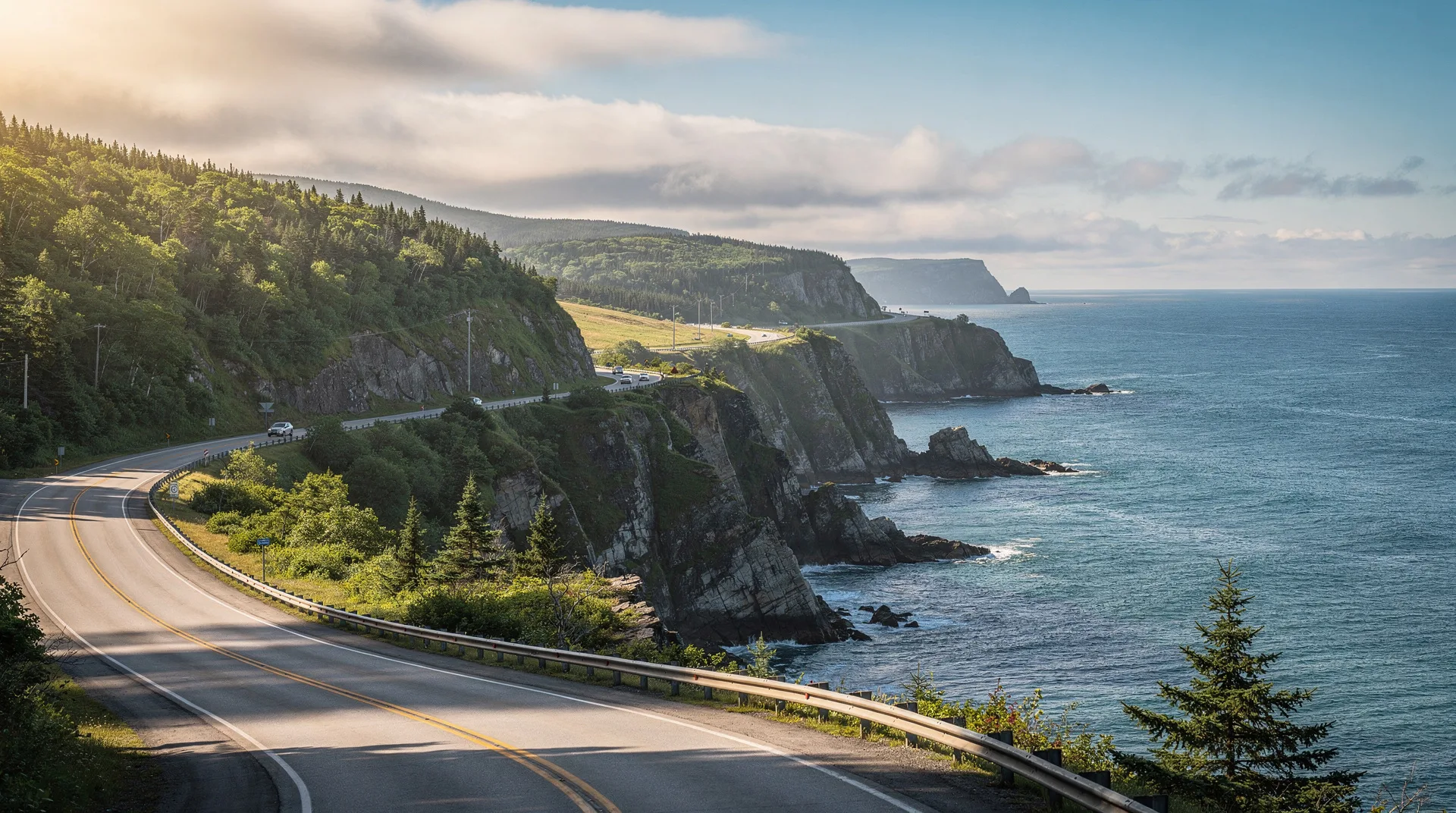
Atlantic Canada is a road-trip region. The four Atlantic provinces — Nova Scotia, New Brunswick, Prince Edward Island and Newfoundland and Labrador — cover a combined area larger than the United Kingdom, with a total population under 2.5 million and highways that range from four-lane motorway (Trans-Canada sections) to narrow two-lane coastal roads. A rental car is essentially mandatory for any itinerary beyond one-city visits, and the driving itself is often a highlight — the Cabot Trail, the Viking Trail, the Bay of Fundy shore and countless secondary roads offer genuinely world-class scenic driving.
This guide covers car rental, the state of the highways, ferries, wildlife risks, winter conditions, border crossings, and the realistic driving times and distances between major destinations across the region.
Why you need a car
Public transit options in Atlantic Canada are limited:
Maritime Bus — scheduled intercity bus network connecting major cities across NB, NS and PEI. Useful for city-to-city moves but slow, and many tourist destinations are not on bus routes.
DRL Coachlines — similar long-distance bus service in Newfoundland, connecting St. John’s to Port aux Basques via the Trans-Canada.
VIA Rail — operates the Ocean train between Montreal and Halifax with stops in Moncton. Three times weekly, scenic, long (roughly 22 hours), useful as an experience rather than a practical transport mode.
Ferries — connect the provinces (NB-PEI, NS-PEI, NS-NL, NL-Labrador) but are primarily used to move cars.
Taxis, Uber and local transit — available in Halifax, Moncton, Saint John, Charlottetown and St. John’s. Beyond these cities, availability is limited.
The cumulative reality: without a car, your Atlantic Canada trip is effectively limited to the capital cities and their immediate vicinities. The Cabot Trail, Hopewell Rocks, PEI National Park beaches, Gros Morne, the Viking Trail, and virtually all coastal destinations require independent driving.
Car rental logistics
Where to rent: All the major international rental brands (Enterprise, Hertz, Avis, Budget, National) operate at the four main Atlantic airports — Halifax Stanfield (YHZ), Moncton (YQM), St. John’s (YYT) and Charlottetown (YYG). Smaller airports (Fredericton, Saint John NB, Deer Lake, Gander, Sydney) have limited rental availability — book in advance.
Peak season tightness: July and August rentals sell out across Atlantic Canada. Book 2-3 months in advance for peak dates. Rates rise substantially in peak summer — expect CAD $60-120 per day for a midsize sedan, $100-180 for a midsize SUV.
One-way rentals: Moderately expensive, but widely available among the major brands. A common strategy is renting in Halifax and returning in Deer Lake (NL) or Charlottetown to avoid backtracking on a multi-province trip.
Under-25 surcharges: Most rental companies charge significantly for drivers under 25. Some do not rent to drivers under 21 at all.
Insurance: Canadian credit card rental insurance coverage varies — check your card’s specific terms. Rental company collision damage waiver (CDW) is expensive but removes risk.
Fuel: Gas stations are widespread on the main highways but less common on Newfoundland’s outlying roads (Viking Trail north of Deer Lake, Burin Peninsula, Avalon outer coast). Fill up before long rural driving sections.
Highways and road types
Trans-Canada Highway (Route 1) — divided four-lane motorway in sections across all four provinces, occasionally narrowing to two lanes with passing sections. Posted limit typically 110 km/h.
Provincial highways (Route 2, 3, etc.) — generally two-lane paved roads in good condition. Speed limits typically 80-100 km/h.
Coastal and rural roads — often narrower, with gravel shoulders and limited signage. Slower going but typically the scenic routes (Cabot Trail, Lighthouse Route, Viking Trail).
Road quality: Generally good to excellent on Trans-Canada and major provincial highways. Some secondary roads (especially in rural Newfoundland and Cape Breton) have significant frost heaves in spring and early summer.
Wildlife: Moose, deer and black bear are significant highway hazards across Atlantic Canada. See the wildlife section below.
The ferries
Atlantic Canada’s ferry network is essential for multi-province travel:
Marine Atlantic (NS to NL) — the sea link between Nova Scotia and Newfoundland. North Sydney, NS to Port aux Basques, NL is the 7-hour daily crossing (year-round); North Sydney to Argentia, NL is a 16-hour summer-only crossing. Vehicle and cabin reservations essential. See our Marine Atlantic ferry guide.
Northumberland Ferries (NS to PEI) — Caribou, NS to Wood Islands, PEI. 75-minute crossing, seasonal (May through mid-December). An alternative to the Confederation Bridge for access to PEI. See Confederation Bridge vs ferry.
Confederation Bridge (NB to PEI) — not a ferry but the fixed link. Toll collected on departure from PEI only. 12.9 km, year-round operation.
Bay Ferries CAT (NS to Maine) — Yarmouth, NS to Bar Harbor, Maine. Seasonal (May-October), 3.5 hours. Useful for US travellers entering from the US Northeast.
Bay Ferries Fundy Rose (NS to NB) — Digby, NS to Saint John, NB. 2.5 hours, year-round. Saves significant driving on Maritime loops.
Provincial ferries — numerous short crossings (Grand Manan, Deer Island, Cape Breton, Newfoundland coastal runs, Labrador). Reservations advisable in summer.
Wildlife hazards
Moose are the most dangerous highway wildlife in Atlantic Canada, particularly in Newfoundland where population density on the Trans-Canada is among the highest of any Canadian highway. Moose-vehicle collisions in Newfoundland are often fatal for the driver due to the moose’s high centre of mass — on impact, the moose typically rolls over the hood and through the windshield.
Prevention:
- Avoid driving at dawn, dusk and night on Newfoundland highways and rural New Brunswick roads during moose-active season (spring through fall).
- Scan the roadside ditches actively, particularly in wooded sections.
- Obey reduced speed limits in marked moose zones.
- Do not swerve to avoid small animals — braking on a straight line is safer.
Black bears are common but typically shy. Road encounters are rare; bear activity at campgrounds and in rural residential areas is a separate consideration.
White-tailed deer are present across all four provinces and are common highway collision causes in rural Nova Scotia and New Brunswick.
Winter driving
Atlantic Canada winters are genuinely demanding. From November through April, expect:
Regular snow events — major storms typically 5-15 per winter across the region. Halifax, Moncton and Charlottetown generally see 200-300 cm annual snowfall; Newfoundland inland and Cape Breton can exceed 400 cm.
Freezing rain — more common in Atlantic Canada than in central Canada. Extremely dangerous driving conditions.
Studded tires — legal in all Atlantic provinces October through April/May. Rental companies do not typically equip vehicles with studded tires; all-weather or winter tires are standard. Request winter tires specifically if renting in winter.
Highway closures — significant winter storms regularly close sections of the Trans-Canada across Newfoundland and New Brunswick. Check 511 road condition services before driving.
Daylight: Short winter days — sunrise 7:30-8:00 AM, sunset 4:30-5:00 PM in December and January. Plan driving for midday.
For most international visitors, Atlantic Canada in winter is not the recommended travel season for independent driving. Professional travel (organised tours, fly-in ski holidays) works; independent road trips introduce significant difficulty.
Border crossings
US-Canada crossings — border posts along the US-Canada border at St. Stephen/Calais (New Brunswick-Maine) and Houlton-Woodstock (NB-Maine). Passports or equivalent approved documents required. Expect queues of 15-60 minutes in peak summer.
NEXUS cards expedite crossings and are worthwhile for travellers making multiple US-Canada crossings.
Vehicle requirements: Proof of insurance is required. Canadian and US insurance are mutually recognised with minor caveats.
ArriveCAN: As of 2026, ArriveCAN is no longer required for most cross-border travel but may be required for specific health advisories. Check current requirements before travel.
Realistic driving times between major destinations
Distances and times between the major Atlantic destinations:
| From | To | Distance | Driving time |
|---|---|---|---|
| Halifax | Cape Breton (Baddeck) | 400 km | 4.5 hrs |
| Halifax | Moncton | 260 km | 2.75 hrs |
| Halifax | Charlottetown | 310 km | 3.5 hrs (incl. Confederation Bridge via Moncton) |
| Halifax | Fredericton | 425 km | 4.5 hrs |
| Halifax | Yarmouth | 305 km | 3.25 hrs |
| Moncton | Hopewell Rocks | 40 km | 40 min |
| Moncton | Saint John | 160 km | 1.75 hrs |
| Moncton | Charlottetown | 175 km | 2 hrs |
| Moncton | Fredericton | 180 km | 2 hrs |
| Charlottetown | Cavendish | 35 km | 40 min |
| Charlottetown | Summerside | 65 km | 55 min |
| North Sydney, NS | Port aux Basques, NL | (ferry) | 7 hrs |
| Port aux Basques | Deer Lake (Gros Morne gateway) | 270 km | 3.25 hrs |
| Deer Lake | St. John’s | 650 km | 7 hrs |
| Deer Lake | L’Anse aux Meadows | 420 km | 5 hrs |
| St. John’s | Gander | 330 km | 3.5 hrs |
| St. John’s | Twillingate | 440 km | 5 hrs |
For the full cross-region trip (Halifax to St. John’s via ferry, overland), plan 2-3 days of driving for the transit alone.
Fuel, rest and services
Fuel stations are widely available on all Trans-Canada sections. In rural Newfoundland (particularly the Viking Trail), stations are 100+ km apart — always top up when stations are present.
Rest areas and washrooms are less developed than in the US Interstate system. Provincial tourism information centres double as rest areas. Fast-food restaurants (Tim Hortons, McDonald’s) are ubiquitous on main highways.
Cell service: Good to excellent on main highways and in towns. Patchy to non-existent on many rural roads, particularly in Newfoundland and Cape Breton. Download offline maps before rural driving.
Browse Atlantic Canada tours and day experiences if you prefer guided optionsSuggested route approaches
The Maritimes Loop (10-14 days): Fly into Halifax, rent, drive to Cape Breton, ferry to Newfoundland (optional) or continue through Nova Scotia to New Brunswick, cross to PEI via Confederation Bridge, return to Halifax via the Wood Islands ferry.
The Fundy Focus (7 days): Halifax or Moncton base, covering Bay of Fundy, Hopewell Rocks, Fundy National Park, Grand Manan and St. Andrews.
Newfoundland Only (10-14 days): Fly into Deer Lake, rent, drive Viking Trail and return to St. John’s, fly out of St. John’s. One-way rental essential.
PEI Focus (5 days): Fly into Charlottetown, rent, circumnavigate the island.
See our Atlantic Canada 7-day, 10-day, 14-day and Fundy loop 7-day itineraries for specific day-by-day planning.
Related content
Marine Atlantic ferry — NS to NL sea crossing.
Confederation Bridge vs ferry — access to PEI.
Atlantic Canada weather — month-by-month climate guide.
Atlantic Canada 7-day itinerary — starter trip plan.
East Coast road trip 14 days — extended itinerary.