Canadian Rockies: Banff, Jasper, Yoho and the Icefields Parkway
What are the Canadian Rockies national parks?
The four Rocky Mountain national parks — Banff, Jasper, Yoho and Kootenay — together form a UNESCO World Heritage Site protecting 20,160 square kilometres of the Alberta and British Columbia Rockies, connected by the legendary Icefields Parkway.
The Canadian Rockies are, by almost any measure, the most spectacular mountain landscape in North America. Stretching 1,500 kilometres along the British Columbia–Alberta border from the US frontier to the Liard River, they combine scale, accessibility, and visual intensity in a way that consistently overwhelms first-time visitors and returns seasoned travellers year after year.
The core of the experience is the four UNESCO World Heritage national parks — Banff, Jasper, Yoho, and Kootenay — connected by the Icefields Parkway, a 232-kilometre highway widely described as one of the great drives in the world. Within this corridor you find Canada’s most iconic mountain lakes, ancient glaciers still visible from the road, the highest density of large mammals in any mountain ecosystem in Canada, and a tourism infrastructure that ranges from luxury heritage hotels to genuine wilderness backcountry.
This guide provides an overview of the entire Canadian Rockies region, helping you understand how the parks relate to each other and how to plan a trip that does justice to the landscape without merely rushing between viewpoints.
Understanding the Canadian Rockies
The Rockies are geologically young — in mountain terms — folded and faulted by collisions between tectonic plates starting around 120 million years ago. The characteristic jagged, toothy profile of the peaks results from the sedimentary rock (limestone, dolomite, shale) being pushed upward and then carved by glaciation over multiple ice ages. The Columbia Icefield, the largest ice mass in the Rocky Mountains, sits at the hydrographic apex of North America — water from it eventually flows to three different oceans: Pacific, Atlantic (via Hudson Bay), and Arctic.
The glacial history explains the most distinctive visual feature of the Rockies: the colour of the lakes. Rock flour — finely ground rock particles suspended in glacial meltwater — scatters light at the blue end of the spectrum, producing turquoise and emerald colours of extraordinary intensity. Moraine Lake, Peyto Lake, Lake Louise, Emerald Lake — all derive their remarkable colour from this mechanism, and all exceed any expectation formed by photographs.
The four parks form a connected ecosystem that supports one of the most complete assemblages of large mammals in North America. Grizzly bears, black bears, wolves, cougars, elk, moose, caribou, bighorn sheep, mountain goats and wolverines all live within the parks. The Bow Valley wildlife corridor in Banff, designed to allow safe passage across the Trans-Canada Highway through a series of overpasses and underpasses, is the most successful large mammal highway crossing system in the world.
Banff National Park
Banff is Canada’s oldest national park (1885) and its most visited, receiving over 4 million visitors annually. The town of Banff, at 1,383 metres elevation in the Bow Valley, provides a remarkably well-developed base: excellent restaurants, hotels of every category from hostel to luxury heritage property, hot springs, museums, and outdoor equipment retailers. Lake Louise village, 58 km northwest of Banff town, offers access to the lake itself and serves as the southern gateway to the Icefields Parkway.
The park’s signature experiences — Lake Louise, Moraine Lake, the Plain of Six Glaciers hike, the Banff Gondola, Johnston Canyon, the Icefields Parkway — are described in detail in our Banff National Park guide. For planning purposes, allow a minimum of three nights in the park; five to seven nights is more appropriate for a thorough experience.
Calgary International Airport is the primary gateway, 128 km east via the Trans-Canada Highway. Banff Airporter and Brewster Express provide shuttle services. Banff town is walkable; getting to trailheads and viewpoints requires either a vehicle, the Parks Canada shuttle system (operated during peak season), or guided tours.
Book a guided Lake Louise, Moraine Lake and Banff Gondola tourJasper National Park
Jasper is larger than Banff (10,878 vs. 6,641 square kilometres) and receives significantly fewer visitors, giving it a quieter, more wilderness-oriented character. The town of Jasper, at the confluence of the Athabasca and Miette rivers, is smaller and less developed than Banff but has everything needed for a multi-day stay.
The park’s highlights include the Columbia Icefield (described in the Icefields Parkway section), Maligne Lake and its Spirit Island (one of the most photographed landscapes in Canada), the Athabasca Falls, Miette Hot Springs, and the Tonquin Valley backcountry. Maligne Canyon, an extraordinarily deep slot canyon walkable via six bridges, is impressive in any season but spectacular in winter when the waterfall below freezes into cathedral columns of ice.
Wildlife is exceptionally abundant in Jasper. The Athabasca Valley is home to hundreds of elk, and wolf sightings are more common here than in Banff. Caribou, increasingly rare in the southern Rockies, are found in the Tonquin and Brazeau areas. Grizzly bears are regularly seen on the slopes above the valley in spring and autumn.
Jasper is accessible from Edmonton (362 km east) or via the Icefields Parkway from Banff (232 km, about 4 hours without stops — allow a full day). Via Rail’s Canadian train connects Toronto, Edmonton, and Jasper, making the town accessible by train with remarkable scenic effect.
See our Jasper National Park guide for the full breakdown of things to do, hikes, and practical planning.
Yoho National Park
Yoho is the smallest of the four parks (1,313 square kilometres) and the most underrated. It sits in BC just west of Banff, accessed via the Trans-Canada Highway from Lake Louise. Despite its modest size, Yoho contains some of the Rockies’ most extraordinary landscapes.
Takakkaw Falls plunges 373 metres from the Wapta Icefield — the second-highest waterfall in Canada — and can be reached within 100 metres by car. Emerald Lake, with its extraordinary colour and the backdrop of the President Range, rivals any lake in Banff. The Natural Bridge, where the Kicking Horse River has carved a rock arch, is a 5-minute walk from the highway.
The Burgess Shale sites within Yoho are UNESCO-designated fossil beds representing one of the most significant palaeontological discoveries in history — 508-million-year-old soft-bodied marine organisms preserved in extraordinary detail. Guided hikes to the Walcott Quarry (led by the Royal Ontario Museum and Burgess Shale Geoscience Foundation) offer access to the sites; book months in advance. The waiting list for these hikes runs years.
The Iceline Trail (20 km loop), climbing above the Yoho Valley to traverse high moraine above the Wapta Icefield, is among the most dramatic day hikes in the Rockies. See our best hikes guide for the full description.
Our Yoho National Park guide covers the park in detail.
Kootenay National Park
Kootenay lies on BC’s side of the Rockies, accessed via Highway 93 South from Castle Junction in Banff. It is the fourth of the UNESCO parks and the least visited by international tourists — partly a result of less dramatic marketing rather than any deficiency in scenery.
The Vermilion Pass, at 1,651 metres, crosses the Continental Divide and marks the boundary between Banff and Kootenay. The Paint Pots — ochre-coloured mineral springs whose banks were historically used by First Nations peoples for pigment — are one of Kootenay’s most distinctive features, accessible by a short trail from the highway.
The Marble Canyon trail (5.4 km return) is a Kootenay highlight: a deep, narrow canyon carved through grey limestone and dolomite by a turquoise torrent, with seven bridges allowing views straight down the slot. In October and November, the canyon’s geological complexity contrasts with larches turning gold on the slopes above.
Radium Hot Springs at the park’s western boundary is one of Canada’s most famous natural hot springs, with its distinctive mineral-rich water flowing into a large pool open to the public year-round. The 3.9-km Redstreak Trail connects the town of Radium to the springs.
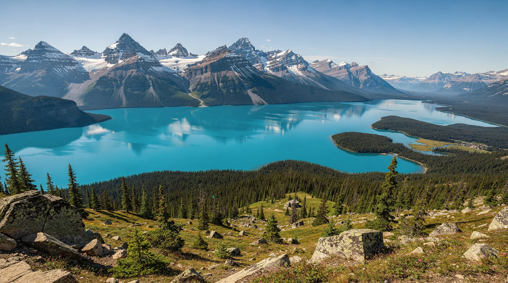
The Icefields Parkway
The 232-km Highway 93 North, connecting Lake Louise in Banff to the town of Jasper, is the spinal cord of the Canadian Rockies experience. Our detailed Icefields Parkway guide covers every major stop on the route. In brief: plan a full day (at least 4–5 hours driving, more with stops), stop at Peyto Lake viewpoint, Bow Lake, Mistaya Canyon, the Columbia Icefield, Athabasca Falls, and the Athabasca Glacier.
The Columbia Icefield is the centrepiece: the largest ice mass in the Rocky Mountains (325 square kilometres), visible directly from the highway with a small visitor centre below the Athabasca Glacier’s toe. Ice Explorer tours onto the glacier surface run from May to October; book in advance. The Glacier Skywalk, a glass-floored observation platform 280 metres above the Sunwapta Valley, is a separate ticketed attraction at the icefield.
Wildlife in the Canadian Rockies
The four parks are managed as a connected ecosystem with extensive wildlife corridors. Viewing is outstanding by any standard:
Elk: Thousands in the parks; Banff townsite and Jasper townsite are surrounded by them. Rut (mid-September to mid-October) brings impressive bugling and dominance displays.
Grizzly bears: Present throughout the parks; spring and autumn are the best sighting seasons as bears forage on slopes visible from valley roads. The Bow Valley Parkway in Banff and the Athabasca Valley in Jasper are reliable areas.
Wolves: Most commonly seen in Jasper, particularly the Athabasca Valley. Dawn and dusk travel on the Icefields Parkway occasionally yields sightings.
Bighorn sheep: Almost always visible near the highway; particularly common at Disaster Point in Jasper and along the Bow Valley Parkway.
Mountain goats: Present on high cliff faces; Jasper’s Miette Road and the approach to Kootenay’s Marble Canyon are reliable spots.
Moose: Willow-choked valley flats in Jasper are prime moose habitat; scan wetlands along the Icefields Parkway and Maligne Lake Road.
Best time to visit the Canadian Rockies
June–July: Best for waterfalls (maximum snowmelt), wildflower meadows opening, and long daylight hours. Lakes are ice-free. Access to high trails beginning. Very busy; book accommodation months ahead.
August: Peak season. All trails open. Weather typically excellent. Lakes at their best colour. Extremely crowded, particularly at Moraine Lake and Lake Louise. Reservations and shuttle bookings essential.
September: The ideal month for many experienced travellers. Crowds dropping off after Labour Day, larches turning gold in late September, elk rut in full swing, grizzlies feeding before hibernation. Excellent photography conditions.
October: Larch season peaks in the first two weeks. High passes receiving snow, some trails closing. Dramatic autumn light. Significantly fewer visitors.
November–April: Winter transforms the parks. Skiing at Lake Louise, Sunshine Village, and Marmot Basin (Jasper). Ice climbing on frozen waterfalls. Cross-country skiing and snowshoeing on summer trails. Lower accommodation prices. Wildlife easier to spot against snow.
May: Transition month. Some trails still snowy; rivers running high with melt. Lower crowds but unpredictable conditions.
How to get around
Car rental: The standard approach. Calgary or Edmonton airports are the most practical starting points. All-wheel drive or four-wheel drive is recommended in spring and autumn; winter tyres are mandatory on many BC roads October through March.
Parks Canada shuttles: Operated during summer peak season (typically late June through mid-October) to Moraine Lake, Lake Louise trailheads, and some Jasper trailheads. Reservation required; book at reservation.pc.gc.ca.
Guided tours: From Calgary or Banff, operators offer day tours to Moraine Lake, Lake Louise, and the Icefields Parkway. Useful for visitors without a rental car or those who prefer not to navigate independently.
Roam Transit: Bus service connecting Banff town, Canmore, Lake Louise and some trails. Limited but useful for certain connections.
Costs (in CAD)
| Item | Cost |
|---|---|
| Parks Canada Discovery Pass (annual, adult) | $72.25 |
| Parks Canada day pass (per vehicle) | $10.50–$21.50 depending on park |
| Lake Louise or Moraine Lake shuttle | $8–$10 per person |
| Athabasca Glacier Ice Explorer tour | $69–$89 adult |
| Glacier Skywalk | $32 adult |
| Banff Gondola | $67–$82 adult |
| Mid-range hotel in Banff (per night) | $200–$400 |
| Fairmont Chateau Lake Louise | $600–$1,500+ |
Where to stay
Banff town: Fairmont Banff Springs (iconic, expensive), Buffalo Mountain Lodge (mid-range, excellent), Brewster’s Mountain Lodge (budget-friendly). Camping at Tunnel Mountain Campground.
Lake Louise: Fairmont Chateau Lake Louise (historic, expensive), Lake Louise Inn (mid-range), Lake Louise Alpine Centre (HI hostel with stunning views).
Jasper: Fairmont Jasper Park Lodge (lakeside resort outside town), Pyramid Lake Resort (comfortable, quiet), Hi-Jasper (hostel, well-run).
Kootenay/Radium Hot Springs: Radium Resort, Bighorn Meadows Resort — good options for those driving through.
Banff backcountry huts: Stanley Mitchell Hut in Yoho (Alpine Club of Canada), Wates-Gibson Hut in Tonquin Valley (Jasper). Booked months in advance.
Frequently asked questions about Canadian Rockies: Banff, Jasper, Yoho and the Icefields Parkway
Do I need a national park pass?
Yes. A Parks Canada Discovery Pass is the most economical choice for any visit of more than a couple of days. It covers all national parks and historic sites for 12 months. Day passes are available at park gates.
Can I visit Banff and Jasper in the same trip?
Yes, and you should. The Icefields Parkway connects them and is itself a major attraction. A 7–10 day itinerary comfortably covers both parks plus Yoho. Drive one-way Banff to Jasper (or vice versa) for the most efficient routing.
What if I can’t book Moraine Lake tickets?
Moraine Lake access is strictly managed. If the Parks Canada shuttle is sold out, book a guided tour that includes Moraine Lake access — operators have allocations separate from the public quota. See our Moraine Lake guide for all current access options.
Is the Canadian Rockies worth visiting in winter?
Yes, for the right visitor. Skiing is excellent at three resorts. The parks are uncrowded. Wildlife is easy to spot against snow. Ice walking in Johnston Canyon is an iconic winter experience. However, many hiking trails are closed or unsafe without crampons, and some roads close seasonally.
How far is Banff from Calgary?
128 km east on the Trans-Canada Highway, approximately 1.5 hours by car. Calgary International Airport is the practical gateway for most international visitors. Shuttle services run several times daily.