Best hikes in Canada: 12 trails you need to walk
What is the best hike in Canada?
There is no single answer — it depends on what you want. The West Coast Trail on Vancouver Island is the most iconic multi-day wilderness hike. The Plain of Six Glaciers in Banff is the best day hike for scenery. The Skyline Trail in Cape Breton is the finest coastal hike.
Canada’s hiking landscape is one of the most varied on earth. Within a country that spans six time zones and five distinct geographic zones — Pacific coast, boreal forest, Arctic tundra, Canadian Shield, Atlantic highlands — you find trails that wind through temperate rainforest dripping with moss, alpine meadows carpeted with wildflowers, coastal cliffs overlooking whales, ancient larch forests turning gold in October, and glaciated peaks that dwarf anything in the continental United States.
The challenge is not finding great hikes in Canada. The challenge is choosing which ones to prioritise in the limited time any visitor has. This guide focuses on 12 trails that represent the best of each region — a combination of iconic classics and overlooked gems, from accessible day hikes to demanding multi-day expeditions.
What makes a great Canadian hike
The trails on this list were chosen against several criteria: quality and variety of scenery, the distinctiveness of the Canadian experience they offer, the ratio of effort to reward, and practical accessibility for visitors without specialist mountaineering skills. None require technical climbing equipment. Most are achievable by any reasonably fit adult with appropriate footwear and preparation.
Canada’s hiking infrastructure varies considerably. The national park trails in the Rockies (Banff, Jasper, Yoho) are well-signed, maintained to a high standard, and serviced by teahouses, campgrounds, and huts. The West Coast Trail on Vancouver Island is a genuine wilderness experience requiring self-sufficiency. Trails in Newfoundland and Cape Breton sit somewhere between — well-marked but sometimes rugged, with limited services.
Trail conditions in Canada are heavily season-dependent. Many high-elevation trails in the Rockies are under snow until late June and can receive snow again in September. Always check current conditions with the relevant Parks Canada office before setting out on any multi-day backcountry route.
1. West Coast Trail, British Columbia (multi-day)
Distance: 75 km point-to-point | Duration: 6–8 days | Difficulty: Very challenging
The West Coast Trail on the west coast of Vancouver Island is arguably the most iconic multi-day hike in Canada. Created originally to provide a rescue route for shipwreck survivors on the notoriously treacherous Pacific coast (the “Graveyard of the Pacific”), the trail today runs through some of the most spectacular temperate rainforest and coastal scenery on earth.
The route is physically demanding. You will ford rivers, climb steep ladders bolted to cliff faces, navigate slippery boardwalks over tidal flats, and camp on beaches where the Pacific surf has been uninterrupted from Asia. Old-growth Sitka spruce and western red cedar tower above the trail. Bald eagles are ubiquitous. Grey whales feed in the surf below clifftop sections. Sea lions bark from offshore rocks.
The trail requires a reservation and a Parks Canada permit (quota strictly limited to 52 per day on each trailhead). Apply online through the Parks Canada reservation system opening in March each year. The season runs May through September; mid-June through August is peak season. Budget CAD $200–$250 in permit and ferry fees in addition to equipment and transport costs.
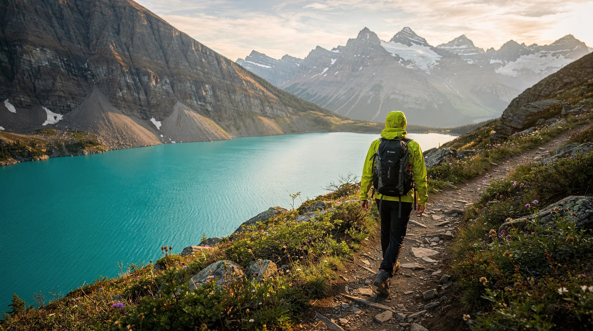
Browse guided tours and experiences on Vancouver Island2. Plain of Six Glaciers, Banff National Park (day hike)
Distance: 13.8 km return | Elevation gain: 365 m | Difficulty: Moderate
This is the finest day hike in the Canadian Rockies and makes a compelling claim for the finest in the country. Starting at the iconic Fairmont Chateau Lake Louise — already one of the most photographed buildings in Canada — the trail follows the shore of turquoise Lake Louise before climbing through subalpine meadows and boulder fields to a plain directly below six named glaciers.
The historic Plain of Six Glaciers Teahouse, operating since 1924 and accessible only on foot or by horse, sits at the end of the maintained trail at 2,135 metres elevation. Homemade soups, sandwiches, and baked goods have been served here, transported up by horse, for over a century. The combination of the teahouse, the glacial scenery behind it, and the extraordinary perspective back down over Lake Louise to the Bow Valley below makes this a hike that consistently exceeds expectations.
Allow 4–5 hours for a comfortable round trip. Start early (before 8 am) to beat the crowds; the Lake Louise area is extremely busy in summer. See our detailed Banff National Park guide for logistics.
3. Skyline Trail, Cape Breton Highlands National Park, Nova Scotia (day hike)
Distance: 9.3 km loop | Elevation gain: 300 m | Difficulty: Moderate
Cape Breton’s Skyline Trail is one of the most celebrated hikes in Atlantic Canada and has become justly famous for its combination of accessible terrain, outstanding coastal views, and reliable wildlife sightings. The trail climbs through Acadian forest — mixed hardwoods including sugar maple, yellow birch and beech — to an open headland at 430 metres elevation, then traverses spectacular coastal barrens above sheer cliffs dropping into the Gulf of St. Lawrence.
The return to the boardwalk platform at trail’s end reveals a panorama of extraordinary scope: the Cape Breton coastline curves away in both directions, the gulf stretches to the horizon, and on clear days the outline of Newfoundland is visible. Moose are commonly seen on the barrens section. The sunset from the platform is celebrated; sunset tours fill quickly in summer.
The Skyline Trail sits on the Cabot Trail, Nova Scotia’s famous 300-km scenic drive — see our Cabot Trail guide for the full route.
Browse Cape Breton experiences and guided tours4. Berg Lake Trail, Mount Robson Provincial Park, BC (multi-day)
Distance: 43.5 km return | Duration: 3–4 days | Difficulty: Challenging
Mount Robson — at 3,954 metres the highest peak in the Canadian Rockies — is so frequently obscured by cloud that seeing its summit is considered genuinely lucky. The Berg Lake Trail beneath it, however, is reliably spectacular. The route climbs through the Valley of a Thousand Falls (named with some exaggeration but considerable accuracy), past three major waterfalls, and into a high alpine cirque where Berg Lake sits directly beneath the Mist Glacier.
The glacier calves constantly into the lake — “berg” refers to the icebergs that float on the turquoise water. Camping at Berg Lake, with the glacier above and the mountain (occasionally) visible, is one of the transcendent backcountry experiences in Canadian hiking. Reserve campsites through BC Parks well in advance; they sell out.
5. Tonquin Valley, Jasper National Park (multi-day)
Distance: 40–55 km depending on route | Duration: 3–5 days | Difficulty: Challenging
The Tonquin Valley is Jasper’s crown jewel backcountry destination: an alpine amphitheatre ringed by the Ramparts, a 50-km curtain of serrated 3,000-metre peaks reflected in Amethyst Lakes. Backcountry campsites and two backcountry lodges (Tonquin Valley Adventures and Wates-Gibson Hut) allow multiple nights in this extraordinary setting.
Wildlife in the valley includes caribou, grizzly and black bears, wolves, golden eagles, and hoary marmots. The Maccarib Pass approach (28 km one-way) through subalpine meadows is the recommended route. Backcountry permits are required and limited; book through Parks Canada as soon as the reservation window opens in January.
Browse guided hiking tours in Jasper National Park6. Iceline Trail, Yoho National Park (day hike)
Distance: 20 km loop | Elevation gain: 690 m | Difficulty: Strenuous
The Iceline Trail in Yoho is among the most visually dramatic day hikes in the Rockies. The trail climbs above the Yoho Valley to traverse a moraine high on the flank of the Wapta Icefield, with continuous views of the Vice President and President glaciers. The combination of turquoise meltwater pools, snow bridges, and the Takakkaw Falls — Canada’s second-highest waterfall — visible 500 metres below makes this a technically challenging but visually extraordinary experience.
See our Yoho National Park guide for logistics and more trail options in this underrated park.
7. Sentinelle Triplande, Parc national des Hautes-Gorges-de-la-Rivière-Malbaie, Quebec
Distance: 14 km return | Elevation gain: 840 m | Difficulty: Strenuous
The Hautes-Gorges is Quebec’s deepest river canyon, carved through the Laurentian Mountains in the Charlevoix region. The Sentinelle trail climbs steeply from the valley floor to a 1,000-metre summit with views down into the canyon that are genuinely astonishing — sheer walls dropping nearly 800 metres to the Malbaie River below, with the canyon stretching away in both directions.
This is one of the most dramatic landscapes in eastern Canada, known to relatively few international visitors. The park is accessible from Quebec City (about 3 hours) or can be combined with a whale watching trip to Tadoussac, 40 km north.
8. Gros Morne, Newfoundland (day hike)
Distance: 16 km return | Elevation gain: 806 m | Difficulty: Strenuous
Gros Morne Mountain in Gros Morne National Park is a UNESCO World Heritage Site for geological reasons as much as scenic ones — the park exposes some of the most significant evidence for plate tectonics anywhere in the world, and the Tablelands (a short drive away) show a slice of the earth’s mantle thrust above the surface. The hike to Gros Morne summit crosses a plateau of barren rock scoured by glaciers, with views over fjords, ocean, and forest that stretch to infinity on clear days.
The summit plateau is notoriously foggy; check the Parks Canada website for current conditions before committing to the hike. The ascent is steep and requires careful navigation in poor visibility.
9. Larch Valley and Sentinel Pass, Banff (day hike)
Distance: 11.5 km return | Elevation gain: 720 m | Difficulty: Moderate–strenuous
One of the most photographed autumn hikes in Canada. The trail climbs from Moraine Lake through Larch Valley — a subalpine bowl filled with alpine larch trees — to Sentinel Pass at 2,611 metres, one of the highest maintained trail passes in the Canadian Rockies. In late September and early October, the larches (which, unlike other conifers, lose their needles) turn brilliant gold, creating a colour explosion against the grey limestone peaks and blue sky that is uniquely spectacular.
Access requires a shuttle reservation from Lake Louise village (private vehicles are prohibited on Moraine Lake Road during peak season). Arrive early; Sentinel Pass is strenuous and the last section involves scrambling on loose scree.
10. Ridgeline Trail, Kananaskis Country, Alberta
Distance: 12 km return | Elevation gain: 500 m | Difficulty: Moderate
Kananaskis Country, the provincial park system adjacent to Banff, offers excellent hiking with a fraction of the crowds. The Ridgeline Trail in Peter Lougheed Provincial Park is typical: a ridge walk with 360-degree views over the Kananaskis Lakes and the Opal Range, accessible in under an hour from the parking area. Kananaskis has no Parks Canada permit requirements and can accommodate self-drive day visits without shuttle bookings.
11. Cape Split, Nova Scotia
Distance: 13 km return | Elevation gain: 150 m | Difficulty: Moderate
Cape Split trail in the Minas Basin area of Nova Scotia provides access to the tip of a dramatic headland above the Bay of Fundy, with views of the world’s highest tides in action. The shoreline below the cliffs sees tide changes of over 12 metres; watching the current rip through the channels at the cape tip is a visceral illustration of the Bay of Fundy’s tidal power.
The trail runs through Acadian forest and along clifftop barrens. It is entirely flat until the final approach to the cape tip, making it accessible to hikers of modest fitness. Combine with a visit to Wolfville and the Annapolis Valley wine region.
12. Aulavik National Park, Northwest Territories
Distance: Multi-day wilderness expedition | Difficulty: Expert wilderness travel only
For adventurers with serious experience and proper equipment, Aulavik on Banks Island in the high Arctic represents the frontier of Canadian hiking. The park protects Arctic tundra with the world’s highest density of muskox, along with caribou, wolves, Arctic foxes and birds. There is no trail system — you navigate by compass and GPS across open tundra. There is no ranger presence. There are no services.
Access is by charter flight from Inuvik (NWT). This is not a hike; it is an expedition. It appears here because nowhere else in Canada more completely embodies the country’s wilderness scale and the possibility of genuine solitude. Some people need to know it exists.
How to book and plan
Parks Canada reservations: Backcountry campsites in national parks (Banff, Jasper, Yoho, Gros Morne) are bookable through the Parks Canada reservation system at reservation.pc.gc.ca. High-demand trails like the West Coast Trail and backcountry Rockies routes open for reservations in January and fill within days. Set calendar reminders.
Guided hiking tours: If you are not experienced with backcountry navigation, guided tours are available for most major trails. These range from day hike guide services to fully outfitted multi-day expeditions with porters, cooks, and camping equipment provided.
Book guided Banff hiking and sightseeing experiencesEssential gear for Canadian hiking
- Waterproof hiking boots (not trail runners for anything technical or multi-day)
- Rain jacket and pack cover (conditions change rapidly everywhere)
- Trekking poles (invaluable on steep descents and river crossings)
- Bear spray (essential in Rockies and BC wilderness; know how to use it)
- Navigation (downloaded offline map on phone plus paper backup for backcountry)
- First aid kit
- Adequate food and water filtration (Sawyer Squeeze or similar)
- Emergency bivouac bag
- Sun protection at elevation (UV is intense above 2,000 m)
Frequently asked questions about Best hikes in Canada: 12 trails you need to walk
Do I need a bear canister?
In most Canadian national park backcountry, food storage is managed via bear-proof food lockers at designated campsites. Carry a bear canister only if specifically required by the park (check with Parks Canada). Bear spray is required in most Rockies backcountry and strongly recommended elsewhere in bear country.
When is the Rockies backcountry accessible?
Most high-elevation Rockies trails are snow-free from mid-July through September. Some lower valley trails open in June. Check Parks Canada trail condition reports; they are updated regularly through the summer.
Is the West Coast Trail suitable for beginners?
No. The West Coast Trail is physically demanding, technically challenging in places (ladders, rope sections, tidal crossings), and requires solid navigation, camping, and wilderness first aid skills. Solo hiking is not recommended. First-time long-distance hikers should build up with easier multi-day routes first.
Do I need permits for day hikes?
Day use in national parks requires a valid Parks Canada Discovery Pass (CAD $72.25/adult for annual pass, or daily park entry fees). Backcountry overnight use requires additional backcountry camping permits. Provincial parks vary; check individual park websites.
What is the best hike in Canada for beginners?
The Plain of Six Glaciers in Banff is an excellent starting point: spectacular scenery, well-maintained trail, teahouse midway, and a clear turnaround point. The Skyline Trail in Cape Breton is similarly accessible and rewarding. Both are excellent for visitors with limited hiking experience.