Quick facts
- Population
- ~75,000
- Distance from Toronto
- 700 km (7 hrs by car)
- Best time
- June to October; September for Agawa fall colours
- Days needed
- 2-3 days
- Border city
- International bridge to Michigan, USA
Sault Ste. Marie — universally shortened to “the Soo” — occupies a specific and geographically significant position: the narrows between Lake Superior and Lake Huron, where the St. Mary’s River descends six metres in a series of rapids. This physical feature has made the Soo important for as long as humans have moved through the Great Lakes basin. The Ojibwe people were fishing the rapids for thousands of years before Europeans arrived. The French built a mission here in 1668. The canal and lock system built in the 19th century made the Soo one of the busiest shipping passages in the world — a status it still holds.
For visitors today, Sault Ste. Marie is primarily a gateway: to the Lake Superior shoreline to the west, to Manitoulin Island and Killarney Provincial Park to the south, and most significantly to the Algoma wilderness to the north via the Agawa Canyon Tour Train — the single most compelling tourism experience in the region and one of the finest in northern Ontario.
The Agawa Canyon Tour Train: why it matters
The Agawa Canyon Tour Train is a full-day excursion into wilderness that has no road access. The train departs Sault Ste. Marie at approximately 8:00 am on the Algoma Central Railway and spends the morning threading through 183 kilometres of Canadian Shield country — crossing trestle bridges over wild rivers, passing through rock cuts blasted in Precambrian granite, climbing through boreal forest — to the Agawa Canyon, where it stops for two hours before returning.
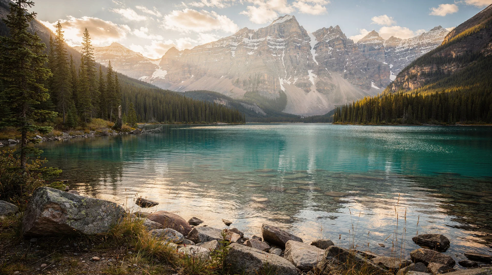
The canyon itself is the centrepiece. The Agawa River drops through a ravine cut 150 metres below the surrounding Shield plateau, and the canyon walls rise sharply from the river. At the canyon stop, passengers walk to Bridal Veil Falls and Black Beaver Falls, or climb the 300-step staircase to the canyon rim lookout — a views over the forest extending to every horizon without a single structure visible.
The fall colour season (peak typically in the last week of September) transforms the journey. The maple and birch forest that lines the route — already spectacular in the compressed, thin-soil Canadian Shield woodland — turns simultaneously and intensely, producing a corridor of red, orange, and yellow that most passengers describe as overwhelming by any previous colour experience. The Agawa Canyon Fall Colour Tour operates through September and into October and sells out well in advance.
See the dedicated Agawa Canyon Tour Train guide for full detail on schedules, booking, what to bring, and how to make the most of the canyon stop.
Soo Locks: Great Lakes engineering at work
The Soo Locks — the canal and lock system on both the American and Canadian sides of the St. Mary’s River — allow ocean-going ships and Great Lakes freighters to transit the 6-metre elevation difference between Lake Superior and Lake Huron. The Canadian lock dates to 1895; the American side has four larger locks, the most significant being the Poe Lock, which handles the largest Seaway-class freighters and was last enlarged in the 1960s.
The scale of shipping through the Soo Locks is staggering: more cargo tonnage passes through than through the Panama Canal, driven primarily by iron ore, coal, and grain moving between the Great Lakes port cities. Watching a 200-metre freighter enter the lock chamber at your eye level, then rise or descend the 6-metre differential, gives a sense of the engineering achievement that makes the entire Great Lakes trade route possible.
Soo Locks Boat Tours offers a three-hour narrated boat tour that goes through the locks themselves — the boat is lifted and lowered in the chamber alongside the freighters (though not simultaneously), and the view of the lock walls rising above the boat deck is a perspective no land-based viewpoint can provide. Tours depart from the Sault Ste. Marie waterfront from late May through October. The two-country tour extends into the American locks on the Michigan side for passengers with valid US entry documentation.
The Soo Locks Park on the American side (connected by the international bridge) has a viewing platform above the locks where ships transit at close range — free, and a good alternative for the visual experience without the boat tour cost.
Canadian Bushplane Heritage Centre
The Canadian Bushplane Heritage Centre on the Sault Ste. Marie waterfront is one of the best aviation museums in Canada for what it represents: the history of the bush plane in opening northern Ontario and the Canadian wilderness to fire suppression, mining, and settlement.
The museum is housed in a heritage flying boat hangar directly on the St. Mary’s River, and the collection includes more than 25 vintage aircraft ranging from float planes and flying boats to the Curtiss HS-2L and the Grumman Goose that worked the northern routes. Several aircraft are suspended in flight position from the hangar structure; others are displayed on the hangar floor with full interpretive access.
The fire suppression history — the aircraft, pilots, and protocols that fought the enormous northern Ontario forest fires of the 20th century — is particularly well documented. The Canadair CL-215 water bomber, a twin-engine flying boat that scoops water from lakes to dump on fires, is perhaps the most Canadian aircraft ever designed, and the example in the museum is accessible for close inspection.
Lake Superior Provincial Park and the Superior shore
Lake Superior Provincial Park, approximately 100 kilometres north of Sault Ste. Marie on Highway 17, is the first major stop on the Trans-Canada along the Superior shore for travellers heading west toward Thunder Bay. The park sits where the lake’s northern shore is most dramatically scenic — quartzite and granite cliffs falling to clear cold water, boreal forest interrupted by river valleys, and backcountry canoe routes into the park interior.
The Agawa Rock Pictographs are the park’s most historically significant site — a collection of Ojibwe rock paintings on a cliff face accessible by a demanding shoreline scramble (steep, slippery rock ledges above the lake; not suitable in rough conditions). The paintings include a depiction of Mishipeshu, the water lynx spirit, and various animals and canoe journeys, and are one of the best accessible ancient rock art sites in Ontario.
The Katherine Cove day-use area and the Gargantua wilderness canoeing area within the park provide comfortable access to the Superior shoreline for swimmers and paddlers. Water temperatures in Lake Superior are cold even in summer — 12–16°C is typical — but the clarity and quality of the water are exceptional.
Where to eat in Sault Ste. Marie
Sault Ste. Marie’s food scene is modest in scale but has several reliable options across price points.
Giovanni’s Ristorante on Queen Street has been a Soo institution for decades — Italian-Canadian cooking in a friendly, wine-list-equipped dining room that handles everything from casual pasta to special occasion dinners. The most consistently recommended restaurant for visitors wanting a proper evening meal.
Loplops Lounge is the city’s best live music venue and a reliable bar for craft beer and light food in an atmosphere that reflects the local arts community.
Sandbar Restaurant and Patio on the waterfront handles summer lunches and casual dinners with a patio overlooking the St. Mary’s River — good for the setting when the weather cooperates.
Tim Hortons at any location, obviously: this is Canada, this is the north, and the Timmies is the operating reality of most mornings on a northern Ontario road trip.
Where to stay
Delta Hotels by Marriott Sault Ste. Marie Waterfront is the best-positioned hotel in the city — directly on the waterfront, walking distance to the Bushplane Centre, the Locks viewpoints, and the Agawa Canyon Tour Train station. Business-class amenities and reliability.
Quality Inn on Great Northern Road covers the budget tier reliably and is well placed for Highway 17 access in both directions.
Camping: Lake Superior Provincial Park has developed campgrounds (Agawa Bay, Rabbit Blanket Lake) that are excellent bases for exploring the park. Book through Ontario Parks well in advance for summer weekends.
Day trips from Sault Ste. Marie
Batchawana Bay and Pancake Bay Provincial Park (70 km north on Highway 17) has one of the longest and finest sand beaches on the Canadian Lake Superior shore — unusual in a region dominated by granite and rock. The beach at Pancake Bay is genuinely beautiful and the provincial park campground makes it a popular summer base.
Gros Cap (30 km west of the Soo) is a headland viewpoint where Lake Superior’s full horizon is visible — a straightforward drive to one of the more dramatic open-water views accessible by car on the Canadian Superior shore.
Searchmont Ski Resort (70 km north) is a surprisingly capable four-season resort with skiing in winter and biking and hiking in summer. Small by Ontario standards but with vertical drop that exceeds many better-known Ontario ski areas.
Getting there
By car: Sault Ste. Marie is 700 kilometres from Toronto via Highway 400 north to Highway 69/17 — approximately 7 hours. The route passes through Sudbury and along the north shore of Georgian Bay through the French River area, with several worthwhile stops possible along the way.
By air: Sault Ste. Marie Airport (YAM) has regular connections to Toronto (Air Canada Express), Sudbury, and several northern Ontario communities. Flying saves significant time and opens the Soo as a base rather than a transit point.
By rail: Sault Ste. Marie is served by VIA Rail from Toronto via Sudbury (the Sudbury-White River corridor), though schedules are limited and the journey is long. The Agawa Canyon Tour Train is a separate operation departing from within the city.
When to visit
September is the best single month — the Agawa Canyon fall colours are at or near peak, the summer crowds have departed, accommodation is available without weeks of advance booking, and the weather is typically clear and cool.
July and August provide the full summer experience: Soo Locks tours at maximum capacity, outdoor activities fully operational, and the longest days.
June is a pleasant compromise — warmer than fall but less crowded than summer peak, and the Agawa Canyon train is running.
Winter (November through March): The Soo experiences significant snowfall and cold temperatures, with cross-country skiing available at several local areas. Not a primary winter tourism destination.
Browse outdoor and wilderness experiences across CanadaSteel and the Soo: industrial heritage
The Sault Ste. Marie steel industry is central to the city’s economic identity. Algoma Steel, the largest employer in the city, operates the steel plant that has been producing steel on the Soo waterfront since 1902. While the plant is not open to public tours, the visible presence of the steelmaking infrastructure along the St. Mary’s River — the blast furnaces, the rolling mills, the rail lines connecting the plant to the docks — gives visitors context for the industrial economy that made the Soo a significant city.
The historical connection between the Algoma Central Railway (which operates the Agawa Canyon Tour Train) and the steel industry is direct: the railway was built in the early 20th century to supply coal, limestone, and iron ore to the Algoma Steel plant from the north. Understanding this industrial geography makes the Agawa Canyon train journey more than scenic — it is a surviving piece of resource-economy infrastructure that happens to be one of the most beautiful railway routes in Canada.
Rock climbing at Batchawana
Batchawana Bay Provincial Park, 75 kilometres north of the Soo on Highway 17, has a small but noteworthy rock climbing area on the granite cliffs above the Lake Superior shoreline. The climbing is not technically extreme but the setting — with Lake Superior visible below the cliff base — makes it unusually dramatic. The park’s beach area is also one of the finer sand beaches on the Canadian Superior shore.
The Superior shoreline north of the Soo has several informal climbing areas on the exposed Shield rock, making the region of interest to trad climbers willing to scout and assess routes independently.
Art and culture in the Soo
Art Gallery of Algoma on Queen Street East is a regional public gallery with a permanent collection that includes significant works by Norval Morrisseau, the Anishinaabe artist from the Lake Nipigon area whose work founded the Woodland School of painting. Morrisseau’s work — characteristically bold, biomorphic, informed by Ojibwe iconography — is among the most internationally significant body of art produced in northern Ontario. The Algoma region, which the Group of Seven also explored extensively (Lawren Harris, A.Y. Jackson, and Frank Johnston all painted in the Algoma country north of the Soo), is represented in the collection through several early-20th-century Canadian art works.
Roberta Bondar Pavilion on the waterfront honours the Sault Ste. Marie-born astronaut who was the first Canadian woman in space (1992). The pavilion is a public gathering space and event venue on the St. Mary’s River shoreline.
Brimley and the American side
The International Bridge connects Sault Ste. Marie, Ontario, with Sault Ste. Marie, Michigan — two cities that share a name, a river, and a border, and are more similar to each other than either is to its own national hinterland. The American Soo has its own attractions: the Museum Ship Valley Camp (a retired Great Lakes ore carrier, now a maritime museum on the Soo, Michigan, waterfront), the American locks viewpoint, and the cross-border experience of entering the US via a bridge with Great Lakes scenery in every direction.
US entry requires a valid passport for Canadian citizens; Americans require a NEXUS card or Enhanced Driver’s Licence for land crossings. The border crossing is generally quick outside of peak summer days.
First Nations communities near the Soo
The Sault Ste. Marie area is within the territory of the Batchewana First Nation and the Garden River First Nation, both of which are Ojibwe communities with territory on the Lake Superior and St. Mary’s River shoreline. The Garden River Pow-Wow (held annually in August) is open to visitors and is one of the larger powwow events in the Algoma region.
The Ojibwe Cultural Foundation’s programming includes events at several northern Ontario communities, including the Soo area. Engaging with the Ojibwe cultural organizations in the region provides context for the landscape that the Agawa Canyon Train crosses — a landscape that has been Anishinaabe territory for thousands of years.
Related guides
- Agawa Canyon Tour Train guide
- Northern Ontario complete travel guide
- Northern Ontario 10-day road trip
- Manitoulin Island travel guide
- Killarney Provincial Park
- Ontario travel guide
Sault Ste. Marie’s appeal as a destination, rather than a waypoint, depends significantly on whether the Agawa Canyon Train is part of your plan. Without it, the Soo is a pleasant but unremarkable mid-sized city with good Great Lakes history attractions. With it — particularly in September’s fall colour season — the city becomes the starting point for one of the most remarkable day journeys available in Ontario.