Quick facts
- Size
- 1,556 km² along Lake Superior's east coast
- Location
- Between Sault Ste. Marie and Wawa
- Best for
- Road trips, coastal hikes, fall colour
- Days needed
- 2-4 days
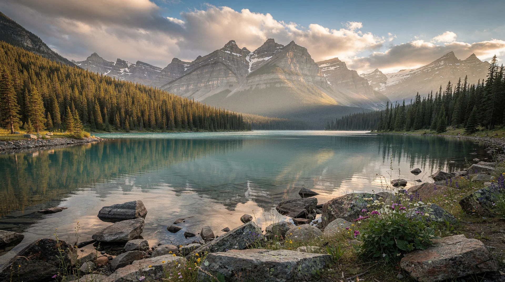
Lake Superior Provincial Park is one of Ontario’s most scenic parks and arguably its most cinematic — 1,556 square kilometres of rugged Canadian Shield coastline, backcountry lakes, and boreal forest along the eastern shore of the largest Great Lake. The Trans-Canada Highway (Highway 17) cuts directly through the park for 80 kilometres, making it simultaneously accessible and remote: you drive through some of the most spectacular coastal scenery in North America without needing to leave the highway. The park contains the famous Agawa rock pictographs (ancient Indigenous paintings on a cliff face above the water), Old Woman Bay (a high-walled crescent cove considered one of the finest beaches on Lake Superior), the challenging Coastal Trail (65 km along the shore), and some of the best car camping and backcountry paddling in Northern Ontario. For Trans-Canada Highway road-trippers, Lake Superior Provincial Park is the single most memorable stop between Toronto and Winnipeg.
This guide covers the main sights, the key hikes, how to plan the drive, and when to visit. For related guides, see Sault Ste. Marie (the southern gateway), Agawa Canyon, and the Northern Ontario guide.
The geography and what makes the park distinctive
Lake Superior is the deepest and coldest of the Great Lakes — 406 metres deep in places, with mid-summer surface temperatures that rarely exceed 10-12°C. The eastern shore where the park sits has been carved by Ice Age glaciers and subsequent weathering into a landscape of granite headlands, pink-sand coves, offshore stacks, and cliff-lined bays. Unlike most of the Canadian Shield, this section has topographic drama — hills rise 300+ metres above the lake, and the coastal views from the highway pullouts rival Cape Breton or the Gaspé.
The park’s boreal forest — spruce, balsam fir, birch, and maple — is the transition zone between southern hardwood and northern boreal, which means the fall colour is exceptional. Peak colour runs from late September to early October.
Key stops along the park
Driving south to north along Highway 17:
Agawa Bay (southern entrance): Large campground, visitor centre, and the main sand beach at the park’s southern end. The visitor centre has excellent interpretive exhibits on the park’s geology, ecology, and Indigenous history.
Agawa Rock Pictographs: A short walk from the highway leads down to a granite cliff face on the water’s edge where Ojibwe artists painted over 100 pictographs 150 to 400 years ago. The paintings depict canoes, serpents, a horned Mishipeshu (the underwater lynx spirit), and other figures. The approach requires scrambling over wet rocks at the lake’s edge — treacherous in rough weather. In calm conditions, the experience of reaching the paintings by water’s edge with the immense Superior stretching out beyond them is extraordinary. Allow 45 minutes to an hour.
Katherine Cove: A small pink-sand cove with turquoise water and a backdrop of rounded granite hills. One of the most photographed spots on Lake Superior. Easy five-minute walk from the parking area.
Old Woman Bay: A crescent-shaped bay with a 200-metre cliff face at its northern end that forms the profile of an old woman’s face (hence the name). Sand beach; cold swimming; easy access directly from the highway. The Nokomis Trail here is a moderate 5 km loop with spectacular bay views.
Sand River: The Sand River drains into Lake Superior here through a series of waterfalls and pools. The Pinguisibi Trail (3 km return) follows the river past multiple rapids and falls. Easy-to-moderate family hike.
Gargantua Harbour and Warp Bay: On the western side of the park, reached by a 14-km rough gravel road. Gargantua Harbour is a protected natural harbour with dramatic cliffs; Warp Bay is a wilderness beach at the end of a 12 km hike from Gargantua. This is the park’s most remote section accessible without a major backcountry trip.
Coastal Trail
The Coastal Trail is the park’s signature hike — 65 kilometres along the coast from Agawa Bay in the south to Chalfant Cove in the north. The full trail is a serious 5-7 day backpack with rough terrain, beach walking, creek crossings, and exposed sections. Day hikers can access shorter sections from several trailheads:
- Agawa Bay to Sinclair Cove (6 km one way): Southern section; moderate terrain.
- Katherine Cove to Sand River (4 km): Central section with some of the best coastal views.
- Old Woman Bay to Bald Head River (7 km one way): Northern section; dramatic cliff sections.
The Coastal Trail experiences rapid weather changes — Lake Superior fog can move in within an hour and coastal sections become genuinely dangerous in wind. Plan conservatively.
Other hikes
Towab Trail: 24 km out-and-back to Agawa Falls, a 25-metre waterfall on the Agawa River. Serious day hike or overnight backpack.
Orphan Lake Trail: 8 km loop through boreal forest to Orphan Lake and a Lake Superior beach. Moderate; one of the best day hikes in the park.
Pinguisibi Trail: 3 km return along Sand River. Family-friendly.
Awausee Trail: 10 km loop with panoramic Lake Superior views. Moderate-to-challenging.
Nokomis Trail (Old Woman Bay): 5 km loop. Moderate.
Camping
Agawa Bay Campground: 145 sites, electrical hookups available; large central campground with beach access. Book through Ontario Parks’ reservation system months ahead for July and August.
Crescent Lake Campground: 42 sites, more rustic, no hookups; inland setting.
Rabbit Blanket Lake Campground: 56 sites, no hookups; the most peaceful of the three drive-in campgrounds.
Backcountry: Paddle-in and hike-in campsites along the Coastal Trail and on interior lakes. Permits required.
Trans-Canada Highway context
The 80-kilometre stretch through the park is part of a longer scenic drive. From Sault Ste. Marie at the south to Wawa (the town just north of the park), the full 230-kilometre drive typically takes 3.5-4 hours without stops but should be budgeted at 6-8 hours to allow for pull-offs, short hikes, and photography. The fuel situation requires planning: services are limited inside the park, with gas stations at Pancake Bay (south of the park), Montreal River Harbour (midway), and Wawa (north of the park).
Paddling
Lake Superior kayaking within the park is for experienced paddlers only — the water is cold (10°C), conditions change rapidly, and rescue is slow. Several interior lakes offer gentler paddling: Orphan Lake, Mijinemungshing Lake, and Crescent Lake all have canoe rentals or launches.
Weather and seasonal planning
June: Blackflies are serious; cool; few crowds; good for hardy hikers.
July-August: The busiest period; warmest temperatures (20-25°C daytime); coldest Lake Superior water is still under 15°C; some smoke haze possible from forest fires.
September: The sweet spot — cooler temperatures, fewer bugs, lighter crowds, early fall colour starting.
Late September to early October: Peak fall colour; genuinely cold nights (near freezing); most memorable visiting window.
Late October to late May: Highway 17 remains open year-round but park facilities closed; winter conditions require full preparation.
Getting there
From Sault Ste. Marie: 1.5 hours north on Highway 17 to the southern entrance at Agawa Bay.
From Toronto: 9 hours via Highway 400 to Parry Sound, then Highway 69/400 to Sudbury, then Highway 17 to Sault Ste. Marie and north to the park. Most visitors break the drive in Sudbury or Sault Ste. Marie.
From Thunder Bay: 7 hours south-east via Highway 17. The section east of Wawa is part of the classic Lake Superior Circle Route.
Combining with other destinations
Lake Superior Provincial Park pairs naturally with:
- Sault Ste. Marie — the southern gateway city
- Agawa Canyon — the train tour from Sault Ste. Marie
- Pukaskwa National Park — two hours north, the wilder sibling
- Thunder Bay — the far northwestern anchor
Related guides
- Sault Ste. Marie destination guide
- Agawa Canyon train tour
- Northern Ontario guide
- Northern Ontario 10-day itinerary
- Thunder Bay
- Pukaskwa National Park