Quick facts
- Size
- 1,878 km² on Lake Superior's northeast coast
- Location
- Near Marathon, Northern Ontario
- Main access
- Hattie Cove (north entrance)
- Visitors per year
- ~14,000 (very low)
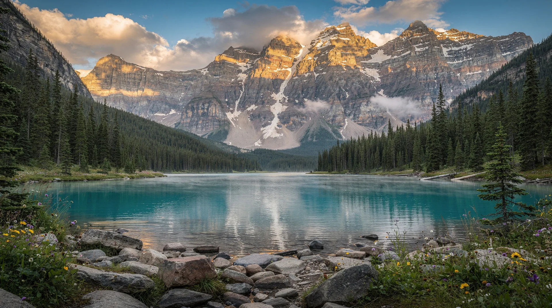
Pukaskwa National Park (pronounced “puck-a-saw”) is Ontario’s only true wilderness national park — a 1,878-square-kilometre tract of rugged Lake Superior coastline, boreal forest, and undeveloped river systems that remains, in the most meaningful sense, wild. The visitor numbers tell the story: Pukaskwa sees around 14,000 visitors a year, compared to more than 800,000 at Banff or 4 million at Niagara Falls. Even within Northern Ontario, it is an order of magnitude quieter than Lake Superior Provincial Park an hour south. What brings the few who come is the Coastal Hiking Trail — 60 kilometres of genuinely remote backpacking along what many experienced hikers consider the most beautiful inland coastline in North America — the sea kayaking along the Superior shore, and the Pic River, the Swallow River, and the park’s inland waterways. For international visitors who have already experienced Banff or Gros Morne and want an Ontario wilderness park that is not a mass-tourism destination, Pukaskwa is the answer.
This guide covers what to see, how to plan a visit, and the level of wilderness experience required. For related destinations, see Lake Superior Provincial Park, Thunder Bay, and the Northern Ontario guide.
What Pukaskwa is (and isn’t)
Pukaskwa is not a national park in the Banff or Jasper sense — there is no townsite, no driving loop, no gondola. The main visitor area is Hattie Cove at the northern entrance, which has a campground, an interpretive centre, a short trail network, and not much else. The real experience of Pukaskwa is on foot or in a kayak beyond Hattie Cove, and it requires backcountry competence.
For day-trippers, Pukaskwa offers:
- A visit to Hattie Cove for short scenic trails (1-3 hours)
- A look at the Coastal Trail’s first few kilometres
- The visitor centre exhibits on Ojibwe culture and the park’s natural history
For overnight and multi-day visitors, Pukaskwa offers:
- The full Coastal Hiking Trail (60 km one way, 3-7 days)
- Kayak expeditions along the coast (multi-day)
- Canoe trips on the Pic River and interior lakes
- Backcountry camping at designated sites
The Coastal Hiking Trail
The Coastal Hiking Trail is Pukaskwa’s signature experience and one of the most challenging and beautiful long-distance hikes in Ontario. It runs 60 kilometres south from Hattie Cove to the North Swallow River, through a landscape that alternates between rocky cliff tops, cobble beaches, river crossings, and boreal forest.
Difficulty: Genuinely hard. The trail is marked but rough, with constant elevation change, wet sections, blowdowns, creek crossings (some serious), and exposed coastal sections. Most hikers budget 6-7 days for the full traverse. Day-hikers commonly walk the first 15-18 kilometres (to Willow River or White Gravel River) and turn back.
Shuttles: Water taxis from Hattie Cove can drop hikers at intermediate points, turning the one-way backpack into point-to-point section hikes. This is the practical approach for most international visitors.
White River Suspension Bridge: The single most photographed feature of the trail is the 23-metre-long suspension bridge 30 metres above the White River’s final falls before the lake. The bridge is 18 km south of Hattie Cove — a classic multi-day or long day-hike target.
Permits and bookings: All backcountry camping requires a permit; bear canisters are mandatory. Book through Parks Canada reservation system well in advance.
Day hikes from Hattie Cove
For visitors not committing to the full Coastal Trail, Hattie Cove has a usable short trail network:
- Beach Trail: 1 km loop from the campground to Horseshoe Beach and back. Easy; stroller-friendly.
- Southern Headland Trail: 2.2 km return through boreal forest to a Lake Superior viewpoint. Easy-to-moderate.
- Halfway Lake Trail: 2 km return through hemlock forest to Halfway Lake. Easy.
- Coastal Trail to Willow River: 15-18 km one way, but the first 3-5 km are manageable as a day hike with dramatic coastal views.
- Manito Miikana Trail: 2.3 km interpretive loop with Anishinaabe cultural content.
Hattie Cove campground
The Hattie Cove campground has 67 sites, of which a portion are serviced (electrical). The campground is well-maintained, with flush toilets, showers, and a picnic shelter. Given the remote setting, book well in advance for July and August. Wilderness walk-in tent sites are also available for backcountry-oriented visitors.
There is no serviced lodging within the park. The nearest motels and hotels are in Marathon (15 minutes north) and Wawa (2 hours south).
Sea kayaking
The Lake Superior coast within Pukaskwa is genuinely world-class sea kayaking — dramatic cliffs, cobble beaches, offshore stacks, and cold clear water. It is also unforgiving: Lake Superior is the second-coldest of the Great Lakes (surface temperature rarely exceeds 10°C even in August), conditions change rapidly, and rescue is slow to impossible in much of the park.
Guided options: Naturally Superior Adventures (based near Wawa) runs guided multi-day kayak trips along the Pukaskwa coast — the recommended option for anyone without significant sea kayaking experience. Trips typically 4-7 days.
Self-outfitted: Requires wetsuits or drysuits, sound weather reading, and serious sea kayak experience. Not recommended for beginners under any conditions.
Indigenous history and cultural content
The park sits within the traditional territory of the Ojibwe of the Pic River (Anishinaabe) and Pic Mobert First Nations. Archaeological evidence shows human presence in the area for at least 2,000 years. The Anishinaabe Camp at Hattie Cove is a cultural interpretation site with reconstructed traditional buildings, summer interpretive programming, and genuine Indigenous cultural content. This is Parks Canada’s partnership with local First Nations at its best.
The park’s name comes from an Ojibwe term meaning “the land where the water flows fast.” Pronunciations vary; park staff accept both “puck-a-saw” and “poo-kass-kwa.”
The Pukaskwa Pits
Along the coast of the park, over 50 documented Pukaskwa Pits — circular stone structures built from beach cobbles — have been found. Their age and function remain debated; theories include vision-quest sites, hunting blinds, or religious structures. Some are visible from the Coastal Trail; visitors are asked not to disturb them.
Wildlife
Woodland caribou (endangered, rarely seen), black bears (common), moose, timber wolves, river otters, beavers, bald eagles, peregrine falcons, and a significant loon population. Bears are genuine — all backcountry users must carry and correctly use bear canisters, and backcountry campers occasionally encounter bears around kitchen areas.
Weather and seasonal planning
Mid-June to early July: Blackflies and mosquitoes are serious; bring head nets.
Mid-July to August: Warmest temperatures (18-22°C); bugs diminish; busiest but still quiet by most standards.
September: The best month — fall colours begin, bugs largely gone, fewer hikers on the trail.
Late September to October: Cold nights, frost risk; Coastal Trail increasingly difficult; park facilities wind down.
Late October to late May: Park generally closed or minimal service; Coastal Trail impassable due to snow and ice.
Getting there
From Toronto: 14 hours by car (serious road trip). Most visitors break the journey in Sault Ste. Marie, Wawa, or Sudbury.
From Thunder Bay: 3-4 hours east on Highway 17.
From Sault Ste. Marie: 5-6 hours northwest on Highway 17.
By air: Thunder Bay (3-4 hours’ drive) has the closest commercial airport with regular service.
Rental car: Essential. No transit reaches the park.
Pukaskwa vs Lake Superior Provincial Park
The two parks are frequently compared. Lake Superior Provincial Park is 1.5 hours south, more accessible from the Trans-Canada Highway, and has more developed visitor infrastructure. Pukaskwa is wilder, quieter, and has the more dramatic backcountry hiking. Most Northern Ontario trips should include one or the other; serious wilderness travellers visit both.
Related guides
- Lake Superior Provincial Park — the more accessible sibling
- Thunder Bay destination guide — closest major city
- Sault Ste. Marie — southern gateway for Northern Ontario trips
- Northern Ontario guide — regional context
- Northern Ontario 10-day itinerary — road trip planning