Sulphur Skyline Trail: Jasper's most rewarding day hike
How hard is the Sulphur Skyline hike?
The Sulphur Skyline Trail is strenuous: 8 km return with 700 m elevation gain from the Miette Hot Springs parking area. Most fit hikers complete it in 3–4 hours. The trail is steep and relentless but the 360-degree summit panorama is among the finest in Jasper National Park.
The Sulphur Skyline Trail may be the most disproportionately rewarding hike in Jasper National Park. Eight kilometres return, 700 metres of elevation gain, and the summit delivers a 360-degree panorama that takes in Jasper’s most remote and dramatic terrain: the Fiddle River Valley, the Ashlar Ridge, the Utopia Mountain massif, and on clear days the peaks of Willmore Wilderness stretching north beyond the park boundary.
The trail is steep and direct — no lengthy forest approach, no gradual warm-up. It climbs hard from the parking area and does not relent much. But the ratio of effort to scenery is exceptional, and the ability to finish the hike at Miette Hot Springs — Canada’s hottest natural springs, 5 minutes from the trailhead — makes this the most satisfying combination of physical exertion and warm-water recovery in the Rockies.
Trail overview
Trailhead: Miette Hot Springs parking area, 61 km northeast of Jasper townsite via the Miette Road Distance: 8 km return Elevation gain: 700 m Difficulty: Strenuous Duration: 3–4 hours return Highest point: Sulphur Skyline summit, 2,070 m Trail surface: Well-maintained switchback trail; exposed ridge and rocky summit area Dogs: Not permitted (adjacent to Miette Hot Springs facility)
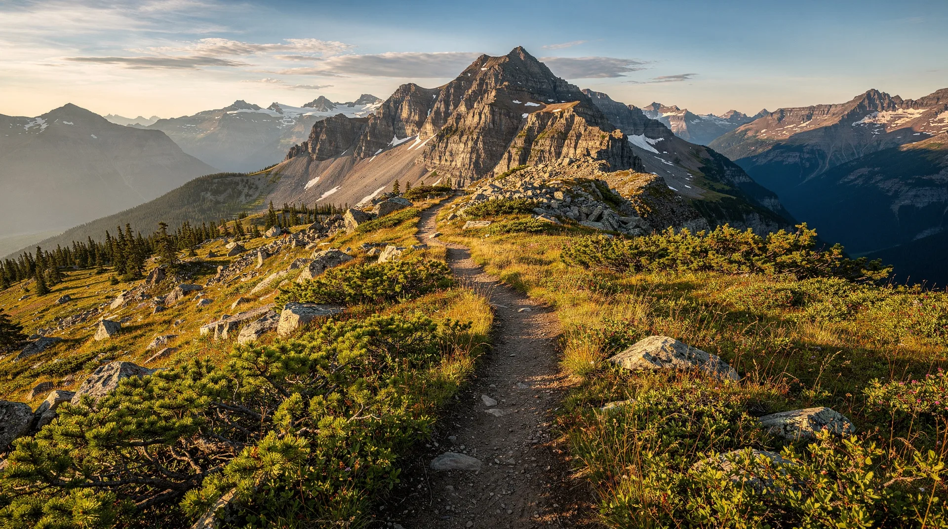
The trail begins from the far end of the Miette Hot Springs parking area and immediately starts climbing through mixed forest. The initial switchbacks through the trees gain elevation quickly; the forest provides some shelter but no relief from the gradient. At approximately 2 km, the trail breaks above treeline onto an open ridge.
From the ridge, the trail follows the exposed crest south and west to the summit pyramid. The final approach crosses rocky terrain with some minor scrambling on loose shale — nothing technical, but requiring attention to footfall.
The summit at 2,070 m is marked by a cairn and offers unobstructed views in all directions.
The summit view
The panorama from the Sulphur Skyline summit is notably different from most Jasper day hike viewpoints because of its position in the northeast section of the park — well away from the main Icefields Parkway corridor. The peaks visible are less famous than the Edith Cavell or Columbia Icefield groupings, which makes the view feel more genuinely remote and undiscovered.
Key features visible from the summit:
- Fiddle River Valley — the long valley stretching northeast toward the park boundary, largely roadless and uninhabited
- Ashlar Ridge — the dramatic serrated ridge system to the east
- Sulphur Ridge — the ridge system running south from the summit
- Utopia Mountain — the prominent peak to the northwest
- Miette Valley — the valley you drove in on, with the Miette Hot Springs visible below
On exceptionally clear days, the Willmore Wilderness — a provincial wilderness area contiguous with the northern boundary of Jasper — is visible beyond the park edge.
Miette Hot Springs: the perfect post-hike reward
The Sulphur Skyline trail is distinctive in pairing immediately with Miette Hot Springs — the hottest natural mineral springs in Canada — without requiring transport or planning. The hot springs facility is a 5-minute walk from the trailhead.
After 700 m of elevation gain and 8 km on steep terrain, soaking in 39°C mineral water is singularly satisfying. The springs are operated by Parks Canada; the facility has two outdoor pools (one at the full 39°C heat, one cooler for a gradual transition), change rooms, and a small concession.
See our dedicated Miette Hot Springs guide for hours, pricing, and what to expect.
Practical tip: Bring a swimsuit and towel in your daypack and drop everything else at your car before entering the springs. The springs close in the late evening; check the current season’s hours to ensure you can soak post-hike.
Practical information
Getting to the trailhead
Miette Hot Springs is 61 km northeast of Jasper townsite via the following route:
- Drive east from Jasper on Highway 16 (Yellowhead Highway) for approximately 42 km
- Turn south onto Miette Road (signed)
- Follow Miette Road 19 km to the Miette Hot Springs facility
The road is paved but narrow and winding. Miette Road is closed from October through May each year. There is no public transit to Miette Hot Springs — a car is required.
Driving time from Jasper: Approximately 1 hour each way.
From Banff: Approximately 4 hours via the Icefields Parkway and Highway 16. A full day trip combining the Sulphur Skyline hike with a Miette Hot Springs soak is feasible but long from Banff — better based from Jasper townsite.
Best time of year
Late June through September: The primary season. The road opens in late May/early June; the trail itself may retain snow patches in June requiring microspikes. July and August are the warmest with the most settled weather; September has excellent conditions and smaller crowds.
Late September and October: The road typically closes in October. Late September visits can coincide with autumn light on the surrounding ridges — the mix of golden larches in nearby valleys (though not on the Sulphur Skyline itself) and clear fall air makes this a scenic option.
Winter: No access. The Miette Road is gated.
What to bring
- Sturdy hiking boots (the summit approach is rocky and loose)
- Trekking poles (the descent is steep and pole support reduces knee strain significantly)
- Warm layers — the summit is exposed and cold with wind even in midsummer
- Rain jacket (afternoon storms possible July–August)
- 2 litres of water (no water sources on the trail after leaving the parking area)
- Snacks
- Bear spray (active bear habitat)
- Swimsuit and towel (for Miette Hot Springs post-hike)
- Sunscreen (UV intensity on the exposed ridge is high)
Wildlife
The Miette Valley area has active populations of grizzly and black bears. The trail has documented bear activity; carry spray in an accessible holster. Bighorn sheep are often seen on the lower slopes and near the hot springs facility — this is one of the more reliable locations for close bighorn encounters in Jasper. Mountain goats are possible on the upper rocky sections. Marmots and pikas occupy the talus below the summit.
Safety considerations
Steep descent: The 700 m descent on steep switchbacks puts significant load on knees. Trekking poles and slow, deliberate footwork on the descent are strongly recommended. The shale sections on the upper trail are slippery when wet.
Weather exposure: The open ridge and summit have no shelter. Afternoon thunderstorms in summer move in with little warning. Plan to be off the summit by 1 pm during thunderstorm season (July–August). If you hear thunder, descend immediately.
Trail marking: The upper section of trail beyond the ridge is marked but the rocky terrain can make the path harder to follow in fog or snowfall. Stay on marked trail.
Related guides
- Miette Hot Springs guide — everything about the hot springs, hours, pricing, and what to expect
- Cavell Meadows hike — wildflower and glacier hike from the other side of Jasper
- Skyline Trail Jasper — multi-day backpacking in Jasper for ambitious plans
- Wildlife watching in Alberta — where to see bears, elk, and sheep in the Rockies
- Jasper National Park guide — full planning guide for a Jasper trip
Frequently asked questions about Sulphur Skyline Trail: Jasper’s most rewarding day hike
How fit do I need to be for the Sulphur Skyline?
700 m of elevation gain in 4 km (one way) is steep by any standard. The trail is continuous — there is no flat section to recover on. Hikers who can comfortably complete a 5 km hike with 400 m elevation gain should be prepared to manage the Sulphur Skyline with effort. Those who struggle on steep climbs should consider the lower-difficulty options in Jasper.
Is the Sulphur Skyline accessible for children?
Older children (12+) with good hiking fitness can manage the trail. The sustained gradient and rocky summit approach make it inappropriate for young children or those unused to strenuous hiking. The hot springs at the end provide excellent motivation, but parents should assess their children’s hiking ability honestly before committing.
Can I hike Sulphur Skyline and do Miette Hot Springs in the same day?
Yes, and this combination is strongly recommended. The logistics are ideal: park at the hot springs facility, hike first (3–4 hours), and soak afterward. Bring your swimsuit and towel in your pack. Allow a full day for the round trip from Jasper townsite including the drive.
What is the difference between Sulphur Skyline and the Jasper Skyline Trail?
These are completely different trails. The Sulphur Skyline is an 8 km return day hike near Miette Hot Springs. The Skyline Trail (officially the Jasper Skyline) is a 44 km one-way multi-day backpacking route from Maligne Lake to Maligne Canyon. Both offer extraordinary views; the Sulphur Skyline is dramatically more accessible.