Cavell Meadows hike: wildflowers & Angel Glacier
How hard is the Cavell Meadows hike?
Cavell Meadows offers two loop options: a lower loop (4 km, easy) past the glacial lake, and an upper loop (8 km, moderate–strenuous) to the alpine meadows with 380 m elevation gain. Both start from the same trailhead below Mount Edith Cavell. The upper loop is the recommended choice for fit hikers.
Mount Edith Cavell is Jasper’s most dramatic peak from road level — a near-vertical north face of pale limestone rising 3,363 metres from the Athabasca Valley, with the iconic Angel Glacier spread across its upper cliff in the shape of wings. The Cavell Meadows hike, starting from the trailhead directly below this wall, combines a glacier-fed lake, one of the finest wildflower displays in the Rockies, and views of Angel Glacier that put you effectively inside the scene rather than observing it from a distance.
This is one of those hikes that rewards different types of visitors differently — the lower loop is accessible and visually stunning; the upper loop adds a serious physical challenge and access to high alpine meadows that feel genuinely remote despite being within a 1.5-hour drive of Jasper townsite.
Trail overview
The Cavell Meadows trail has two distinct loops that share the same trailhead. Most visitors do one or both in a day.
Lower loop (path of the glacier)
Distance: 4 km loop | Elevation gain: 80 m | Difficulty: Easy | Duration: 1–2 hrs
The lower loop follows the old glacial moraine around Cavell Pond, a small lake at the base of the north face fed directly by meltwater from Angel Glacier. The pond surface is often dotted with small icebergs — chunks of ice that calve from the glacier’s snout above and fall to the pond below. The scale of the north face from the pond shore is extraordinary — rock walls rise hundreds of metres directly above the water.
The moraine you walk along is newly exposed terrain. Fifty years ago, the glacier extended over where you now stand. The pace of retreat is visible in the vegetative succession — the closest zones to the current glacier face are barren rock; slightly further back, mosses and early pioneers have established; beyond that, shrubs and eventually forest mark older deglaciated terrain. It is an accidental living museum of climate change.
Iceberg display: Icebergs in the pond are most dramatic in early summer (late June–July) when calving rates are highest. By late August and September the pond typically has less floating ice. The visual drama is significant even without icebergs — the scale of the wall and the colour of the meltwater are arresting at any time.
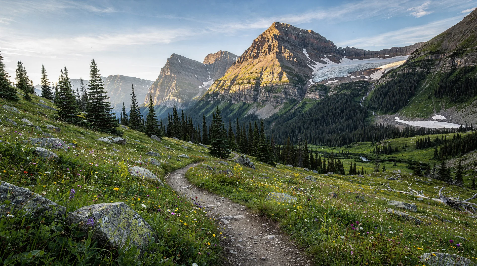
Upper loop (Cavell Meadows)
Distance: 8 km loop | Elevation gain: 380 m | Difficulty: Moderate–strenuous | Duration: 3–5 hrs
The upper loop branches from the lower loop and climbs steeply through recovering sub-alpine forest before breaking into the open meadows at approximately 2,100 m elevation. The meadows extend for 2 km across the flank of the peak, with Angel Glacier visible across the cirque and the Athabasca Valley stretching north below.
The wildflower display in the upper meadows is among the finest in Jasper National Park. Peak bloom typically occurs from mid-July through early August. The display includes mountain valerian, Indian paintbrush, fleabane, and countless smaller alpine species. The combination of wildflowers in the foreground, the pale limestone wall of Edith Cavell rising above, and Angel Glacier draped across the upper cliff creates a composition that appears repeatedly in Jasper promotional material — and is more impressive in person.
The upper loop rejoins the lower trail for the descent, making it a natural circuit.
Angel Glacier: what you are looking at
Angel Glacier is a hanging glacier occupying the north face of Mount Edith Cavell. It is named for the distinctive wing shape created by two ice lobes spreading from the upper snowfield — the wings of an angel, with the central couloir as the body.
Like almost all glaciers in the Rockies, Angel Glacier is retreating. Historical photographs from the early 20th century show ice extending far lower on the cliff face. The current terminus above Cavell Pond is significantly higher than it was 50 years ago. The calving events that create the pond’s icebergs are a product of that retreat — ice at the unsupported margin breaks off under gravity.
The glacier is not accessible from the trail; the walls below it are sheer and avalanche-prone. Views from the lower loop pond shore and the upper meadows are the intended experience.
Practical information
Getting to the trailhead
Mount Edith Cavell Road branches from Highway 93A approximately 13 km south of Jasper townsite. The road is 14.5 km long, narrow, and winding — it is closed to vehicles over 9 metres (29 ft) and to trailers of any length. The road is closed in winter and typically opens from late June through October.
Parking: The parking area at the trailhead is limited to approximately 40 vehicles. It fills by 9–10 am on summer weekends. Parks Canada operates a mandatory shuttle system from Jasper townsite during peak season — verify the current year’s requirements on the Parks Canada website before driving up.
From Jasper: The drive to the trailhead takes approximately 1.5 hours from town due to the road speed limits. Budget the full round trip (Jasper to trailhead and back) at 3 hours of driving alone.
Best time to hike
Mid-July to early August: Peak wildflower season in the upper meadows. Angel Glacier is calving actively; the pond has icebergs. Weather is generally most stable.
Late July to August: Meadows past peak bloom but still scenic. Fewer icebergs in the pond. The most reliable window for a full upper loop without snow.
Late June: The road typically opens in mid-to-late June. The meadows may still have snow patches; the lower loop is accessible and often has the best iceberg display of the year.
September: Smaller crowds, autumn tints, clearer air. The meadows have finished blooming but the landscape is still rewarding. Snow possible at any time after mid-September.
October onwards: Road closes. No winter access to the trailhead.
What to bring
- Waterproof hiking boots (the lower loop has muddy sections; upper loop has wet meadow areas)
- Warm layers — the upper meadows are cold with wind off the glaciated face, even in July
- Rain jacket
- Sun protection (the meadows are fully exposed)
- 2 litres of water per person (no potable water on the trail)
- Snacks and lunch for the upper loop (3–5 hours total)
- Bear spray (active bear habitat in the meadow areas)
- Camera with wide angle capability — the north face requires wide framing from the pond
- Binoculars (useful for watching ice calve from the glacier)
Wildlife and ecology
The Cavell Meadows area is prime habitat for several notable species:
Grizzly bears: The meadows have active grizzly populations feeding on alpine vegetation through summer. Bear spray is mandatory on the upper loop.
Hoary marmots: Large, social ground squirrels that whistle loudly from rock piles throughout the upper meadow. Their alarm calls often signal nearby predators worth watching for.
Pikas: Small, round mammals related to rabbits that live in talus zones and call with a distinctive sharp squeak. Common on the lower moraine sections.
Clark’s nutcrackers: The loud, grey-and-black birds that congregate near the parking area and trailhead are Clark’s nutcrackers — a species that depends on whitebark pine seeds and serves a critical role in seed dispersal.
Vegetation succession: The lower moraine is one of the most visible examples of glacial succession in the Rockies — bare rock transitioning through moss, herb, and shrub communities to eventual forest over centuries.
Safety considerations
Calving ice: The glacier terminus above Cavell Pond produces ice falls. Do not stand directly below the glacier face or cross the pond margin toward the base of the wall. The marked trail keeps visitors at a safe distance, but wandering off-trail toward the cliff base carries real risk.
Steep upper loop terrain: The upper loop climbs quickly on rocky terrain with some exposure. Wet conditions make the rock slippery. The descent requires careful footing.
Weather: Afternoon thunderstorms are common in July and August. The upper meadows are fully exposed. Plan to be off the upper loop by 1 pm in unstable weather.
Wildlife near vehicles: Do not leave food visible in your vehicle at the trailhead — bear activity near the parking area is documented.
Combining with other Jasper day hikes
The Cavell Meadows hike pairs well with:
- Sulphur Skyline Trail — Jasper’s most rewarding summit day hike, starting from Miette Hot Springs (1.5 hours from Jasper in a different direction)
- Wilcox Pass hike — 1.5 hours south near the Columbia Icefield, best viewpoint on the Icefields Parkway
- Miette Hot Springs — reward yourself after the Cavell Meadows climb with a soak in Canada’s hottest natural springs
- Jasper National Park guide — full planning guide for a Jasper visit
Frequently asked questions about Cavell Meadows hike: wildflowers & Angel Glacier
Can I see Angel Glacier without hiking?
Partially. From the parking area, the north face of Mount Edith Cavell is visible and Angel Glacier can be identified with binoculars. The full visual experience — the glacier framed by the cirque walls, with the pond below — requires the lower loop (4 km, easy). The parking area view alone is impressive but incomplete.
Is the upper Cavell Meadows loop suitable for children?
The lower loop is suitable for most children who can walk 4 km on uneven terrain. The upper loop has a steep, sustained climb (380 m over 4 km with a pack) that requires solid hiking stamina. Most children over 10 who are accustomed to hiking can manage the upper loop; younger children or those unused to hiking should do the lower loop and assess from there.
When do the wildflowers peak?
Peak wildflower bloom in the upper meadows typically falls in mid-July through early August. The exact timing varies by year depending on snowpack and spring temperatures. A heavy snow year pushes bloom back; a warm spring advances it. Parks Canada trail condition reports for the Cavell Meadows area in late June and early July give accurate current-year timing.
Is there any fee to access the Cavell Meadows trail?
The trail itself is free once in the park, but Banff/Jasper National Park entry requires a valid Parks Canada Discovery Pass. Daily or annual passes apply to all visitors. The shuttle (when operating) may have a separate booking fee.