Dempster Highway: driving Canada's road to the Arctic
How long does it take to drive the Dempster Highway?
Driving time from Dawson City to Inuvik is about 14-16 hours for 736 km, but nobody drives it in a day. Plan a minimum of 4 days one-way with an overnight at Eagle Plains, and ideally 7-10 days round-trip including side trips to Tombstone Territorial Park, the Arctic Circle, and the Tuktoyaktuk extension.
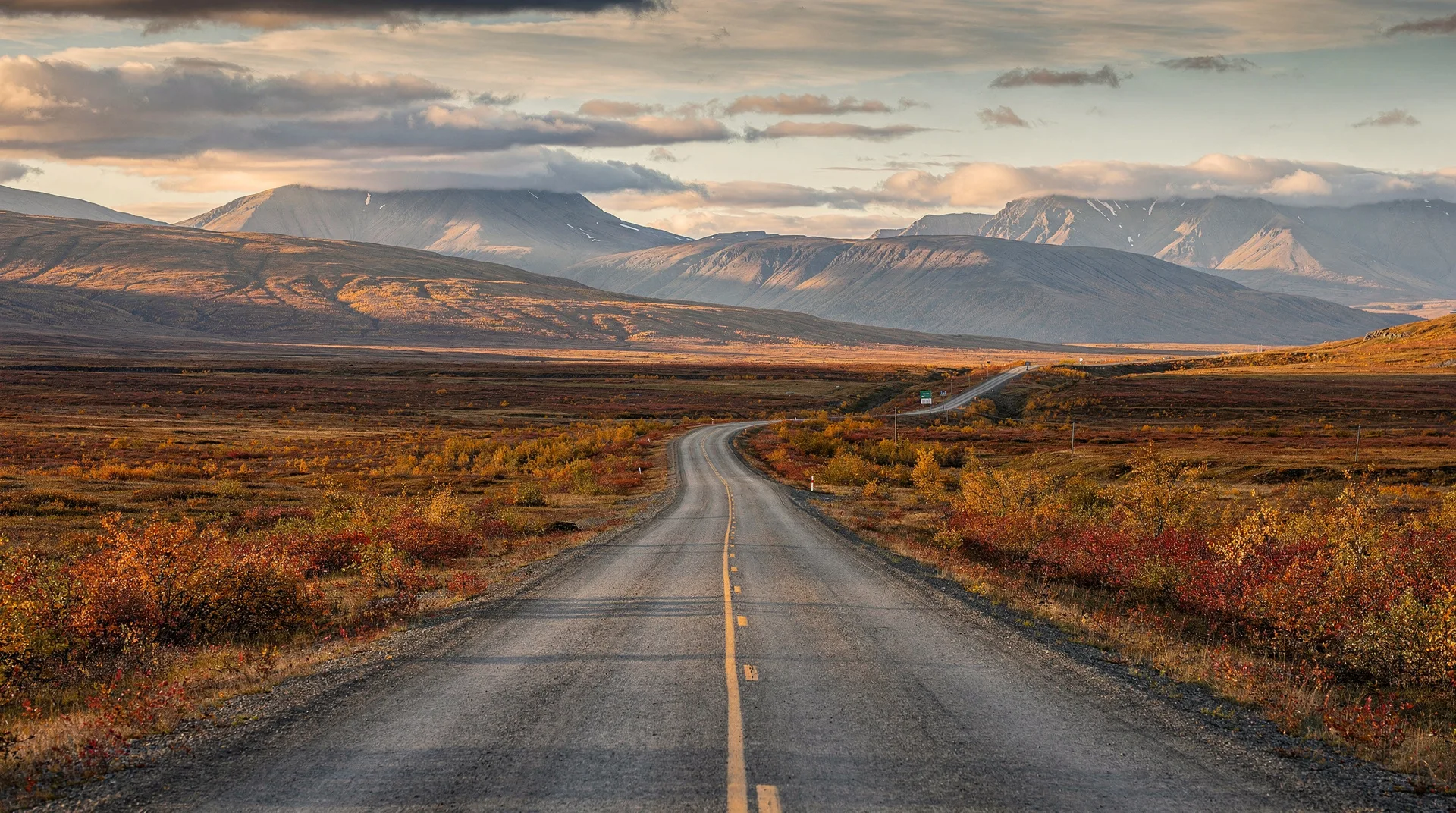
Somewhere past kilometre 400, the last spruce trees give up and retreat behind you, and the Dempster Highway climbs into the Richardson Mountains across open tundra. The sky is vast; the road is an ochre line laid across the land; there are no fences, no powerlines, no villages, nothing but the occasional caribou tracking alongside the gravel. This is what you came for — the feeling that the country is so large it has simply absorbed the trappings of infrastructure and given them back as a thin ribbon of gravel running north.
The Dempster Highway is the only public road in Canada that crosses the Arctic Circle. Opened in 1979, extended to the Arctic Ocean in 2017 via the Inuvik-Tuktoyaktuk Highway, it connects Dawson City to the Beaufort Sea across 887 kilometres of subarctic and arctic wilderness. Driving it is consistently cited among the great road trips of the world, and deservedly — but it requires more planning than most Canadian road journeys. This guide covers the logistics.
The Dempster is the centrepiece of the Yukon-NWT north; our Dempster Highway destination page has the broader regional context, and the 7-day Dempster itinerary provides a day-by-day plan.
The road, end to end
The Dempster officially begins at the Klondike Highway, 40 km east of Dawson City, and ends at Inuvik, NWT, 736 km north. From Inuvik, the newer Inuvik-Tuktoyaktuk Highway (ITH) extends another 148 km to the shore of the Arctic Ocean at Tuktoyaktuk, for a total possible drive of 884 km to salt water.
Distance table (southbound to northbound)
| Segment | Distance | Approx. drive time |
|---|---|---|
| Dempster Corner (km 0) → Tombstone Interpretive Centre (km 71) | 71 km | 1 h 15 |
| Tombstone → Eagle Plains (km 369) | 298 km | 5 h |
| Eagle Plains → Arctic Circle (km 405) | 36 km | 35 min |
| Arctic Circle → Fort McPherson (km 549) | 144 km | 2 h 30 |
| Fort McPherson → Tsiigehtchic (km 608) | 59 km | 1 h 15 (includes Peel River ferry) |
| Tsiigehtchic → Inuvik (km 736) | 128 km | 2 h (includes Mackenzie ferry) |
| Inuvik → Tuktoyaktuk (ITH) | 148 km | 2 h 30 |
| Total Dempster Corner → Tuktoyaktuk | 884 km | ~16 h driving |
Driving times assume dry conditions. Wet gravel, heavy truck traffic, or a flat tire all add significant time.
Surface and road conditions
The Dempster is unpaved gravel throughout. The surface quality varies considerably:
- Good sections — recently graded, firm, washboard-free; comfortable at 80-90 km/h.
- Washboard sections — particularly on descents and approaches to creeks; comfort speed drops to 50-70 km/h.
- Calcium-chloride stretches — treated with calcium chloride dust control; when wet, these become exceptionally slippery, almost like driving on soap.
- Frost heaves and soft spots — common north of Eagle Plains where permafrost is degrading; watch for signed warning markers.
Rain transforms the road. Dry gravel that you drove north on at 85 km/h can be a slick, axle-deep mud channel after a thunderstorm. It is essential to check road conditions (511yukon.ca and mvhighways.ca for NWT) before departure and daily en route.
The two ferry crossings at the Peel River (near Fort McPherson) and the Mackenzie River (near Tsiigehtchic) operate from roughly late May/early June to late October, with interruptions during freeze-up and break-up. Winter driving uses ice crossings on the same rivers — typically open from mid-December to mid-April.
Tires, fuel, and vehicle preparation
The single most common question is about tires. The answer is unambiguous: carry two full-sized spares, not one. The sharp shale gravel chews rubber aggressively, and punctures, sidewall cuts, and outright tire failures are routine on the Dempster. Cell coverage is non-existent between Dawson City and Inuvik, and roadside assistance is a satellite phone call followed by a multi-hour wait.
Recommended vehicle preparation:
- Two full-sized spares matched to your vehicle. Roof rack or bed-mounted is fine.
- Proper tires — load-range E light-truck tires on trucks and SUVs; all-terrain tread preferred over highway tread; new or near-new condition.
- Tire plugs, an air compressor, and a torque wrench — for field repairs of punctures.
- A full-size jack that can lift a fully loaded vehicle on soft gravel.
- Extra fuel — two 20-litre jerry cans are standard for the Eagle Plains-to-Inuvik section.
- Rock guards on headlights and a windscreen protection film if your rental company allows.
- Satellite communicator (Garmin inReach or similar) — cell signal is only in Dawson, Eagle Plains (limited), Fort McPherson, Tsiigehtchic, Inuvik, and Tuktoyaktuk.
Most major rental companies in Whitehorse and Dawson do not permit their cars on the Dempster. Specialist operators (North of Ordinary, Klondike Recreational Rentals, and a few others) rent Dempster-ready vehicles at a premium; expect CAD $250-400 per day for a properly equipped 4x4.
Fuel stops
There are only four fuel stops between Dawson City and the Arctic Ocean:
| Km marker | Community | Fuel | Notes |
|---|---|---|---|
| 0 (Dempster Corner) | Klondike River Lodge | Yes | Last fuel before 370 km of wilderness |
| 369 | Eagle Plains | Yes | Only fuel stop on the Dempster itself; also motel, cafe, repair shop |
| 549 | Fort McPherson (off-highway) | Yes | Gwich’in community; groceries, cafe |
| 608 | Tsiigehtchic | Yes (limited hours) | Small Gwich’in community at the Mackenzie confluence |
| 736 | Inuvik | Yes | Largest northern community; full services |
| 884 (ITH) | Tuktoyaktuk | Yes (limited) | Arctic Ocean; plan conservatively |
A fuel tank of 500 km range is marginal; 700 km is comfortable. Carry spare fuel for peace of mind.
When to drive: best season
The Dempster is open year-round, but conditions vary dramatically.
June to early September: the main driving season
This is when most travellers do the trip. The road is fully open (ferries running from late May/early June), days are long (midnight sun north of the Arctic Circle from early June to early July), and side trips (hiking in Tombstone, boat trips from Inuvik) are available. Mid-June through August are peak; early September adds autumn tundra colour but with rapidly shortening days and increasing road-weather risk.
Late September-October: shoulder
Beautiful low-angle light, first snow on the Ogilvie Mountains, thinner crowds. Ferry service reliable through to early-to-mid October. The end of the viable summer driving window.
November-mid-April: winter driving
A completely different trip. Ice roads replace the ferries. Temperatures of -30°C to -45°C are routine. Aurora activity is excellent. Winter Dempster travel requires a vehicle prepared for extreme cold, full recovery equipment, and genuine experience. Not a first-time road trip.
Avoid: late April to mid-June and late October to mid-November
Break-up and freeze-up close the rivers (ice too rotten for ice crossings, not yet clear for ferry). The Dempster itself may be driveable, but the crossings are not, and you can reach neither Tsiigehtchic nor Inuvik without them.
Key stops along the way
Tombstone Territorial Park (km 50-110)
The first stretch of the Dempster traverses Tombstone Territorial Park, a 2,200 km² reserve of jagged black granite peaks, tundra valleys, and remarkable autumn colour in late August and early September. The Tombstone Interpretive Centre at km 71.5 is the park headquarters, with trail information, exhibits, and a superb campground. Grizzly Creek, Angelcomb Peak, and the demanding Grizzly Lake backcountry route are the signature day hikes. Allow at minimum a full day here, more if hiking.
Ogilvie-Peel viewpoint (km 260)
A high-elevation pullout with a panoramic view over the Peel River watershed to the Wernecke Mountains. Not signposted particularly well, but conspicuous on a clear day.
Eagle Plains (km 369)
The Eagle Plains Hotel is the only accommodation and fuel between Dawson City and Fort McPherson, sited on a ridge of unglaciated terrain in the middle of nowhere. The motel has 32 rooms, a surprisingly good restaurant, a small bar, and a mechanic’s shop. Rooms are CAD $180-220 per night; book well ahead in summer. The hotel is where every Dempster traveller converges, making it a good place to exchange road-condition notes.
Arctic Circle (km 405)
Marked by an interpretive plaque and a wide pullout. Crossing the Arctic Circle (66°33’ N) is a genuine milestone; photograph the sign, sign the visitors’ book at Eagle Plains, and continue on.
Richardson Mountains pass (km 460)
The Dempster climbs from the Eagle Plains plateau over the Richardson Mountains into the Northwest Territories. The border is marked by a modest sign; the transition from the Yukon tundra to the NWT side — more boreal, more river-scribbled, with the Mackenzie floodplain opening out — is striking.
Fort McPherson (km 549, off-highway)
A Gwich’in community on the Peel River, population ~700. The Fort McPherson Tent and Canvas Co. produces canvas goods well-known across the north; their small shop is worth a stop. Fuel, cafe, and a small grocery.
Tsiigehtchic (km 608)
A tiny Gwich’in community at the confluence of the Arctic Red River and the Mackenzie. The ferry lands you directly in the village. Cemetery on the hill has commanding river views.
Inuvik (km 736)
The main town of the Mackenzie Delta, population ~3,300. Has the iconic Our Lady of Victory (igloo) church, good cafes, and is the staging point for boat and flight trips into the delta. The summer festival is worth catching if you are here in late July.
Tuktoyaktuk (ITH, km 148 from Inuvik)
Since the ITH opened in 2017, it is possible to drive to the Arctic Ocean. Tuktoyaktuk — a mainly Inuvialuit community of ~900 on the Beaufort Sea — has the ocean itself (a ritual dip in the surf is obligatory), pingos (ice-cored hills unique to permafrost landscapes), and a genuine sense of having reached the end of the continental road network.
Browse Yukon and northern Canada toursSuggested itineraries
4 days: Dawson City to Inuvik (one way, flying back)
- Day 1: Dawson → Tombstone (71 km; hike or camp)
- Day 2: Tombstone → Eagle Plains (300 km)
- Day 3: Eagle Plains → Inuvik (370 km; Arctic Circle photo, Peel and Mackenzie ferries)
- Day 4: Inuvik-Tuk day trip or a rest day; evening flight back to Whitehorse
7 days: round trip with Tuktoyaktuk
Our detailed 7-day Dempster Highway itinerary plans this version in full.
10+ days: full Yukon-north trip
Combine the Dempster with Dawson City’s Klondike history, a boat trip on the Yukon River, and a few days in Kluane National Park on the return. This is the ideal length if you are flying in from outside the territory. See our Yukon destination hub and Dawson City page for planning.
Frequently asked questions about Dempster Highway: driving Canada’s road to the Arctic
Is the Dempster Highway safe to drive?
Yes, with proper preparation. It is not technically difficult — no mountain passes with hairpin bends, no extreme grades — but the remoteness, gravel surface, and tire risk require planning. Thousands of travellers complete the Dempster every summer without incident.
Can I do it in a rented 2WD car?
Technically possible in summer, but not advisable. Most rental companies in Whitehorse and Dawson City explicitly prohibit their vehicles on the Dempster; if you are permitted to go, you drive at full own risk. The specialist rental operators that allow it supply 4x4s or AWD SUVs with extra spares for good reason.
How much cell signal is there?
Effectively none between Dawson and Inuvik, except brief patches at Eagle Plains, Fort McPherson, and Tsiigehtchic. Starlink Mini is increasingly common among Dempster travellers. At minimum, carry a satellite communicator.
Is there accommodation along the way?
Eagle Plains Hotel (km 369), Fort McPherson (limited — Peel River Inn), and Inuvik (full range) are the main options. Camping is otherwise universal; the Tombstone, Engineer Creek, Nitainlaii, and Gwich’in Territorial Park campgrounds are the main established sites.
What wildlife will I see?
Grizzly bears, black bears, caribou (the Porcupine herd crosses the highway in spring and fall), moose, Dall sheep in the Ogilvies, and abundant birds. Driving at dawn or dusk maximises sightings.
Can I drive the Dempster in winter?
Yes, but only with proper preparation — a properly winterised vehicle, full recovery equipment, satellite communications, and realistic expectations about extreme cold. It is not a beginner’s winter drive.