Quick facts
- Population
- 45,000
- Best time
- Jan–Mar (aurora) / Jun–Sep (midnight sun & hiking)
- Languages
- English
- Days needed
- 7-14 days
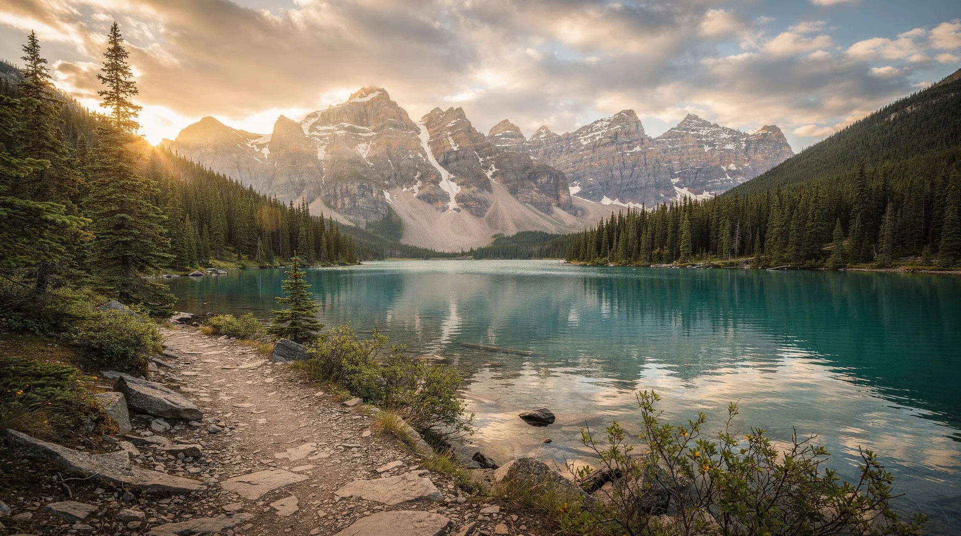
The Yukon covers 483,000 square kilometres — an area larger than Spain — and is home to fewer than 45,000 people. Nearly every one of those people, and virtually all of the territory’s services, infrastructure, and points of entry, are concentrated in Whitehorse, the capital, which sits midway along the Alaska Highway in the territory’s south. Beyond Whitehorse, the Yukon unfolds in a scale that defies ordinary description: ranges of mountains stretching without break to the horizon, river systems running hundreds of kilometres through unbroken boreal forest, and a silence in the backcountry that is one of the rarest things available to a modern traveller.
This is the land of the Klondike Gold Rush, which in 1898 drew 100,000 prospectors across some of the most hostile terrain in the world in pursuit of gold discovered in a tributary of the Yukon River. It is the land of the aurora borealis, visible from August through April with a probability and intensity that few other accessible destinations can match. It is the land of the midnight sun, where in June the sun simply does not set and the concept of night becomes theoretical. And it is the land of the Kluane icefields, the Tombstone Mountains, the Dempster Highway, and the Yukon River — each one a superlative in its own category.
The Yukon’s regions and how to navigate them
The Yukon’s geography divides roughly into accessible zones radiating from Whitehorse. Understanding them before you visit helps enormously in planning a realistic itinerary.
Southern Yukon and Kluane is the most visited region — accessible via the Alaska Highway and anchored by Kluane National Park and Reserve with its icefields, glaciers, and Mount Logan (5,959 metres, the highest peak in Canada). Haines Junction serves as the gateway and is 158 kilometres west of Whitehorse.
Central Yukon and Dawson City is the Gold Rush heartland. The Klondike Highway runs 536 kilometres north from Whitehorse to Dawson City, passing through boreal forest, river valleys, and the occasional roadhouse. Dawson City itself is one of the most genuinely atmospheric historic towns in Canada — Victorian-era false-front buildings, a gold dredge preserved in its final operating position, and a functioning gambling hall running the kind of entertainment that made the gold rush town famous.
The Dempster Highway corridor begins just east of Dawson City and runs 672 kilometres north to Inuvik in the Northwest Territories, crossing the Arctic Circle and passing through the Ogilvie and Richardson Mountains, two of the most dramatic and least-visited mountain ranges in North America. The Tombstone Territorial Park lies along its first section and is arguably the most spectacular landscape in the Yukon.
Northern Yukon includes Ivvavik National Park along the Arctic Ocean coast — one of the most remote parks in Canada, accessible only by charter aircraft. It protects the calving grounds of the Porcupine caribou herd.
Whitehorse: the essential starting point
No visit to the Yukon begins anywhere other than Whitehorse. The city has regular flights from Vancouver (Air Canada and WestJet) and seasonal services from other Canadian cities. The Alaska Highway, the Klondike Highway, and the Haines Road all pass through or begin here. Tour operators, gear rental shops, vehicle rental agencies, and wilderness outfitters are concentrated in the city.
Whitehorse is also more rewarding than its gateway role might suggest. Miles Canyon (a dramatic basalt gorge on the Yukon River a few kilometres south of downtown), the SS Klondike National Historic Site (a restored sternwheel riverboat), the MacBride Museum, and an impressive trail network give the city genuine substance as a destination. The Takhini Hot Springs north of the city — where soaking in 42°C water while the aurora moves overhead in winter has become something of a signature experience — is worth an evening.
Book a Yukon aurora borealis late-night viewing tour from WhitehorseAurora borealis in the Yukon
The Yukon sits directly beneath the auroral oval — the ring of maximum auroral activity that circles the northern magnetic pole. This positioning, combined with the territory’s dry continental climate (which produces clear skies far more reliably than coastal regions), makes it one of the best places in Canada to observe the northern lights.
The aurora is visible in the Yukon from August through April — any time the sky is sufficiently dark and auroral activity is sufficient. The peak months for intensity and probability are January through March, when nights are long and the atmosphere is frequently stable. September and October also offer good conditions, particularly around the autumn equinox when geomagnetic activity typically increases.
From Whitehorse, aurora tour operators transport guests from their hotels to dark-sky sites 20–40 kilometres from the city, providing heated viewing areas, photography assistance, and interpretation of the lights’ significance in Yukon First Nations traditions. Beyond Whitehorse — at any point on the Klondike Highway or the Dempster — the aurora is visible without any light pollution at all, directly from the road.
Browse Canada northern lights and aurora experiencesDawson City and the Gold Rush
Dawson City is worth every kilometre of the 536-kilometre drive from Whitehorse. Sitting at the confluence of the Yukon and Klondike Rivers, it was the epicentre of the Klondike Gold Rush of 1896–1899 — the most celebrated gold rush in North American history, which drew tens of thousands of prospectors from across the world in one of the last great mass migrations of the pre-aviation era.
At its peak in 1898, Dawson City had a population of over 30,000 — making it, briefly, the largest city west of Winnipeg in Canada. Today its population is around 1,400, and the boardwalk storefronts, restored false-front hotels, and working dance hall on Front Street preserve the atmosphere of a gold rush boomtown with a thoroughness that few historic sites manage. The Klondike Visitors Association and Parks Canada both run programming in the town.
The SS Keno, a restored sternwheeler, sits in permanent dry dock on the Yukon River front. The Palace Grand Theatre, built by Arizona Charlie Meadows in 1899, still stages performances. Diamond Tooth Gertie’s Gambling Hall — Canada’s oldest legal casino — runs cancan shows and games of chance in the fashion of the gold rush era.
Outside the town, the Dredge No. 4 National Historic Site preserves a massive gold dredge in the exact position where it ceased operating in 1959, surrounded by the gravel tailings it left behind across several kilometres of the Klondike valley. Walking through the dredge’s mechanical innards, accompanied by Parks Canada interpretation, gives the gold rush economy an industrial reality that the Front Street heritage buildings alone cannot convey.
Tombstone Territorial Park and the Dempster Highway
The Dempster Highway begins 40 kilometres east of Dawson City and runs 672 kilometres to Inuvik, crossing the Arctic Circle at kilometre 405 and ending at the Mackenzie Delta. It is the only public highway in Canada to cross the Arctic Circle and one of the most remarkable drives in the country.
The first 72 kilometres pass through Tombstone Territorial Park, a landscape of jagged granite spires, tundra plateaus, and mountain lakes that has a visual drama unlike anywhere else in the Yukon. The Tombstone Range — dark, sharp peaks rising from golden tundra — has become the defining image of the northern Yukon. The park’s day-use area at kilometre 72 has an interpretive centre (open June to September) and the trailhead for the Grizzly Lake route, a 20-kilometre day hike into the heart of the peaks.
Driving the full Dempster to Inuvik takes two to three days at a reasonable pace. The road is gravel for its full length; two spare tyres are strongly recommended, and fuel planning is essential — services are available at the Eagle Plains Hotel (kilometre 369) and Fort McPherson (kilometre 548) but not between them. The reward for this logistical care is one of the great wilderness drives in North America: caribou herds crossing the road, grizzly bears on the tundra slopes, wolverine tracks in the dust, and the astonishing landscape of the Richardson Mountains near the Northwest Territories border.
Midnight sun: the Yukon in summer
The concept of the midnight sun is easy to understand intellectually and difficult to prepare for experientially. At the summer solstice, Dawson City (64°N) receives over 21 hours of usable daylight, with the sun barely dipping below the horizon at midnight before rising again. In Whitehorse (60.7°N), nights shrink to a few hours of deep dusk.
The practical consequences are significant. Wildlife is active at all hours. Hiking can continue to 11pm without a headlamp. The quality of light in the late evening — golden, horizontal, and constant — is extraordinary for photography. And the psychological effect of perpetual light, disorienting at first, eventually produces a kind of energised restlessness that is one of the peculiar pleasures of a northern summer.
For visiting in summer, plan for this. Accommodation that does not have effective blackout curtains will make sleeping difficult. Many visitors adapt by treating the endless daylight as permission for longer days and later dinners rather than fighting it.
Yukon River paddling
The Yukon River runs 1,149 kilometres through the territory, from its headwaters at the British Columbia border to the Alaska border — and continues another 1,000 kilometres to the Bering Sea. From Whitehorse to Dawson City is 740 kilometres of manageable canoe and kayak travel — the route taken by gold rush stampeders in 1898, with the critical exception that Miles Canyon (once a genuinely dangerous rapid) is now a calm stretch above a dam.
The Whitehorse to Dawson paddle takes 14 to 21 days at a relaxed pace, with camping on river bars throughout. Several operators in Whitehorse rent canoes and kayaks with shuttle options. The river’s current does most of the work; flat-water paddling experience is sufficient for the main route, though reading water and awareness of weather conditions are important. This is a genuine wilderness route — services are minimal between Whitehorse and Carmacks (half distance), and Carmacks and Dawson City.
Shorter sections are also possible. The Whitehorse to Carmacks stretch (360 km) is popular for 7-day trips. Various outfitters run guided river journeys of different lengths.
Kluane National Park and Reserve
Kluane is the Yukon’s crown jewel — a 22,013-square-kilometre UNESCO World Heritage Site containing the largest non-polar icefields in the world, Canada’s highest peak (Mount Logan, 5,959m), and one of the densest grizzly bear populations on the continent. The park is accessed from Haines Junction, 158 kilometres west of Whitehorse on the Alaska Highway.
The Kaskawulsh Glacier trail (30 km return) is the signature hiking experience — a full-day route ending at the terminal moraine of a glacier several kilometres wide. Flightseeing over the icefields in a small fixed-wing plane remains the most dramatic way to comprehend the park’s scale. Dall sheep are frequently visible from the highway near Sheep Mountain above Kluane Lake.
When to visit the Yukon
January to March: Deep winter. Average temperatures in Whitehorse range from -15 to -25°C. The aurora is the primary draw, and the quality of viewing is frequently exceptional. Dog sledding, skiing, and snowshoeing are all active. Daylight is short but the clarity of winter light on snow-covered mountains is its own reward.
May to June: Transition season. Snow is leaving the valleys, wildlife is active, migratory birds are arriving, and wildflowers begin in June. The midnight sun arrives in mid-June. Trails at altitude may still be snow-covered in May.
July to August: Peak summer. Warmest temperatures (20–25°C in valleys). All trails open, paddling is ideal, and the territory receives its largest visitor numbers. Book accommodation and vehicle rentals well in advance.
September: One of the finest months. Autumn colours — the Yukon’s boreal forest turns gold and red with extraordinary speed — begin in late August and peak in mid-September. The aurora becomes visible again. Bear activity is high as animals prepare for winter. Temperatures are dropping but the weather is often stable.
Practical information for the Yukon
Getting there: Whitehorse Erik Nielsen International Airport receives daily flights from Vancouver (Air Canada, WestJet) and seasonal services from Calgary and Edmonton. The Alaska Highway connects from British Columbia for those driving north.
Getting around: A vehicle is effectively essential for exploring beyond Whitehorse. Car rental in Whitehorse is available from major chains and local operators; book well in advance for summer, as the Yukon has relatively few rental vehicles and they sell out. Gravel roads on the Dempster require appropriate tyres.
Costs: The Yukon is not cheap. Fuel prices are higher than southern Canada. Accommodation in Dawson City and along the Dempster is limited and in high demand. Budget conservatively and book early.
Communications: Cell coverage exists in Whitehorse and Dawson City and along main highways in patches. Beyond these areas, coverage is essentially absent. A satellite communicator device (SPOT or Garmin inReach) is strongly recommended for any backcountry travel.
Frequently asked questions about Yukon Territory
Do I need a visa to drive through Alaska to reach the Yukon? American territory (Alaska) is traversed by the Alaska Highway, so yes — standard Canadian entry requirements apply when returning to Canada from Alaska. US visitors need their passport. Canadians need proof of citizenship. The customs crossing at the Alaska-Yukon border is routine.
Is the Dempster Highway driveable in a regular car? A high-clearance vehicle is strongly recommended. While the road is technically passable in a standard car under ideal conditions, the gravel surface, stream crossings, and distance from services make this a poor choice. A 4WD SUV or truck is ideal. Carry two spare tyres, extra fuel, and a tow rope.
What vaccinations or health preparations do I need? No specific vaccinations are required or recommended beyond standard travel health precautions. The main health considerations are hypothermia and cold injury risk in winter, and bear encounter preparedness year-round. Travel insurance covering evacuation is strongly recommended for any backcountry travel.