Quick facts
- Total distance
- 735km (Dawson City to Inuvik)
- Surface
- Gravel throughout
- Season
- Open year-round; ice road extension to Tuktoyaktuk in winter
- Fuel stops
- Eagle Plains (km 369); Fort McPherson; Tsiigehtchic
- Best time
- Late June to September; February–March for winter driving
The Dempster Highway is one of the great road trips in North America — 735 kilometres of gravel road running north from the Klondike Highway, 40 kilometres east of Dawson City, across the Ogilvie Mountains, the Eagle Plains plateau, the Richardson Mountains, and the Mackenzie Delta to Inuvik in the Northwest Territories. It is the only public road in Canada to cross the Arctic Circle, and it passes through a wilderness so large and so uninterrupted that the experience of driving it is categorically different from any other road journey in the country.
The highway opened in 1979, named for Inspector Francis Dempster of the North-West Mounted Police, who led dogsled patrols along this route in the early 20th century. For most of its length, it follows traditional travel routes of the Han, Gwich’in, and Inuvialuit peoples — routes shaped over millennia by the movements of caribou, by the river systems that served as travel corridors, and by the intimate knowledge of a land that sustained entire cultures.
There are no paved sections, no cell service for most of the route, and fuel stops at intervals of up to 370 kilometres. This is genuine remote driving, and it requires preparation. But the payoff — Tombstone Mountain rising from tundra, the Arctic Circle sign in the Richardson Mountains, the Mackenzie River delta from above, the possibility of seeing caribou herds in migration, grizzly bears on open tundra, and the midnight sun sitting on the horizon at 2 AM — justifies every kilometre.
Planning the Dempster: essentials before you go
Tire situation: Flat tires are not a risk on the Dempster — they are a near-certainty over a multi-day drive. Carry two spare tires. The gravel surface contains sharp rock that defeats even good tires. Check tire pressure at every fuel stop. Many Dawson City visitors arrange tire rental with their vehicle; Yukon Alaska RV and other local operators understand the Dempster reality.
Vehicle: A standard passenger car can drive the Dempster in good conditions, but a vehicle with decent clearance — SUV or pickup — handles the surface better and reduces the stress of washboarding and gravel spray on the undercarriage. 4WD is not required in summer but makes the ice road extension in winter much safer.
Fuel: There are three fuel stops along the route:
- Eagle Plains (km 369 from the junction): the only service between the start and the NWT border. The Eagle Plains Hotel is also the only accommodation along this stretch.
- Fort McPherson (km 549): a Gwich’in First Nation community with fuel and basic services.
- Tsiigehtchic (km 626): at the junction of the Arctic Red River and Mackenzie River.
- Inuvik (km 735): the endpoint and full service.
Carry a fuel jerry can. The stretch from the highway junction to Eagle Plains is 369 kilometres — beyond the range of a vehicle that departs with a less-than-full tank.
Rental car restrictions: Many standard Canadian car rental agreements explicitly prohibit the Dempster. Check before booking. Operators in Dawson City (Budget, Yukon Alaska RV) typically permit Dempster travel. Using a major brand vehicle from Whitehorse without checking your agreement is a risk.
Ferries: Two river crossings on the Dempster require free government ferries — the Peel River crossing (near Fort McPherson) and the Mackenzie River crossing (at Tsiigehtchic). Ferries operate June through October, weather permitting. In winter, ice bridges replace the ferries, typically from December or January. The shoulder periods (November and spring breakup) see the crossings close — plan timing accordingly. Check Yukon Government road conditions updates before departure.
Browse guided Yukon and Dempster Highway road trip tours from Whitehorse and Dawson CityThe route: section by section
Dawson City to Tombstone (km 0–71)
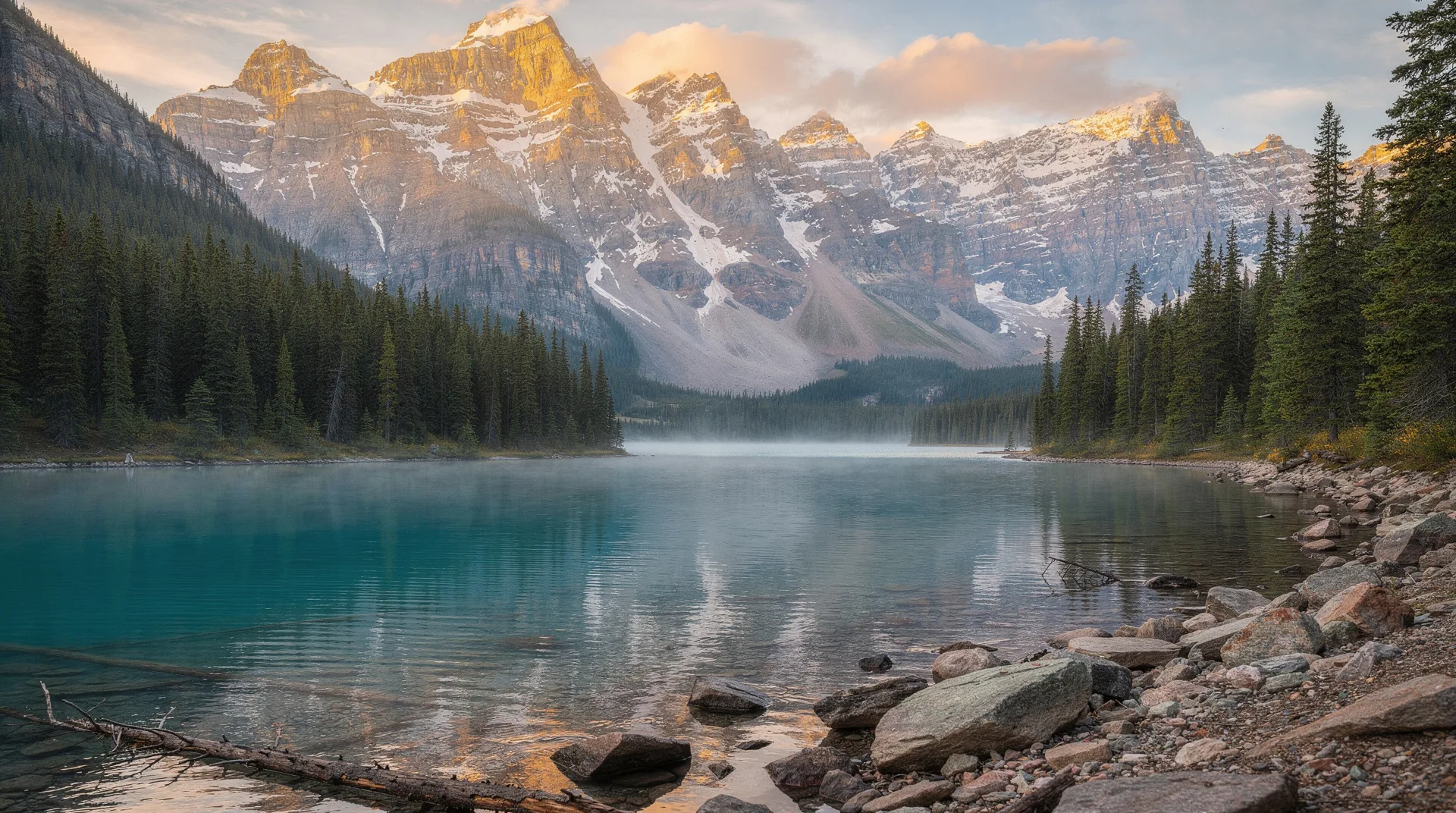
The first 71 kilometres of the Dempster are a perfect introduction to what follows: gravel through boreal forest that gradually opens as elevation increases, with the Ogilvie Mountains beginning to define the horizon. At km 71, the Tombstone Interpretive Centre marks the entrance to Tombstone Territorial Park — the most photographically dramatic section of the highway and the only one with established hiking infrastructure.
The iconic Tombstone Mountain rises just west of the highway; from the interpretive centre, the view up the North Klondike River valley with the jagged quartzite peaks framing the far end is one of the quintessential Yukon images. Stop here even if you’re not hiking — the landscape visible from the road alone is extraordinary.
Tombstone to Eagle Plains (km 71–369)
After Tombstone, the highway climbs to Engineer Creek, passes through open tundra plateaus in the Ogilvie Mountains, and eventually descends to the Eagle Plains plateau — a broad, rolling subarctic landscape that stretches to the horizon in all directions. The Arctic Circle crossing, marked by a signpost, occurs at approximately km 405 (from the highway junction).
Widgeon Lake, visible from the highway in the Ogilvie Mountains, is one of the best wildlife-watching spots on the route — scan the surrounding ridgelines for Dall sheep and the tundra below for grizzlies. The scale of the landscape here — no trees, no structures, no evidence of humans for 100 kilometres in any direction — is genuinely affecting.
The Eagle Plains Hotel at km 369 is the only stopping point between the start and Fort McPherson. It has rooms (basic, expensive by southern standards), fuel, a restaurant, and remarkable northern atmosphere — the kind of remote roadhouse that functions because there is simply nothing else for 350 kilometres in any direction.
Arctic Circle crossing and Richardson Mountains (km 369–490)
North of Eagle Plains, the highway crosses the Arctic Circle and begins the long climb into the Richardson Mountains — the range that forms the border between Yukon and the Northwest Territories. The Richardson Mountains are lower than the Ogilvies but more open: sweeping tundra above treeline, with long sightlines across to Alaska to the west.
This section in mid-June offers midnight sun in its most literal form — the sun traces the horizon without setting, illuminating the tundra in a low gold light that lasts the entire “night.” Gravel bars in the creek valleys show old caribou antler sheds; golden eagles patrol the ridgelines.
The NWT border, marked by a sign and a territorial boundary, crosses through the heart of the Richardson Mountains. On the Yukon side, management falls to the territorial government; on the NWT side, to the GNWT. Regulatory details (fishing licences, campfire rules) change at the border.
Fort McPherson and the Peel River (km 490–549)
Fort McPherson (Tetlit Zheh) is a Gwich’in community of about 800 people on the west bank of the Peel River. It is the site of a famous RCMP tragedy — in 1910–11, Inspector Francis Dempster led a patrol from Dawson City to Fort McPherson and back, losing nine of his party to starvation and cold. The Lost Patrol story is central to the highway’s history and is commemorated at the community’s cemetery.
For the modern traveller, Fort McPherson offers fuel, a grocery store, and — if you’ve arranged it in advance — the possibility of meeting Gwich’in community members involved in tourism and cultural programming. The community’s connection to the land is deep and continuing; the Gwich’in Nation’s relationship with the Porcupine Caribou Herd is one of the most significant human-wildlife relationships in northern Canada.
Tsiigehtchic, Mackenzie Delta, and Inuvik (km 549–735)
The final section descends from the Richardson Mountains through the Mackenzie Delta country — a vast lowland of lakes, channels, and boreal forest carved by the Mackenzie River system. Tsiigehtchic (formerly Arctic Red River) is a small Gwich’in community at the confluence of the Arctic Red River and the Mackenzie River, where the second ferry crossing takes vehicles across to the east bank.
From the Mackenzie River crossing, the highway runs through the delta to Inuvik — a planned community established in the 1950s as the regional hub for the western NWT. Inuvik marks the end of the Dempster, but in winter, a further extension — the Inuvik to Tuktoyaktuk Highway — continues the journey to Tuktoyaktuk on the Arctic Ocean coast.
Wildlife on the Dempster
The Dempster passes through some of the most productive wildlife habitat in the North. The following are realistic expectations:
Grizzly bears: Common in the Tombstone area and along the tundra sections of the Ogilvie and Richardson Mountains. Most often seen feeding on berries in late summer. Do not stop to photograph from close range; binoculars from the vehicle window are the appropriate approach.
Caribou: Two major herds — the Porcupine and the Fortymile — migrate through the Dempster corridor seasonally. During migration (typically April–June northward, August–October southward), the highway can be crossed by thousands of animals. Timing your drive to coincide with migration is a matter of luck and current information from Yukon Government wildlife updates.
Dall sheep: Visible on the rocky ridgelines of the Ogilvie Mountains, particularly in the Tombstone section and the Engineer Creek area.
Moose: In the boreal sections at the start and end of the route. Most commonly seen at dawn and dusk near wetlands and creek edges.
Golden eagles: Abundant along the mountain sections in summer, hunting ground squirrels on the tundra.
When to drive the Dempster
Late June to September: The optimal window. Ferries are running, daylight is abundant (including midnight sun in late June and early July), and the gravel surface is at its best. Wildlife is active and visible. July is peak season with the highest visitor numbers, though “high season” on the Dempster is relative — you may not see another vehicle for hours.
February and March: The winter driving season. Ice bridges replace the ferries, and the Inuvik-Tuktoyaktuk Highway is accessible, extending the route to the Arctic Ocean. Aurora viewing from the Richardson Mountains or Eagle Plains is extraordinary. Temperatures reach -40°C; this requires proper cold-weather preparation but is a genuinely rewarding northern experience.
The shoulder (November, April–May): The most uncertain times. Ferry and ice bridge transitions create unpredictable closures. Check conditions with Yukon Government road updates before committing.
Book Yukon northern wilderness and road trip experiences from WhitehorseCost realities
The Dempster is not an inexpensive road trip. Fuel costs are significant — the full round trip from Dawson City to Inuvik and back is approximately 1,500 kilometres, and fuel in Eagle Plains and the NWT communities is priced at northern remote rates (typically 40–60% above southern Canadian prices). Accommodation is limited and expensive: Eagle Plains Hotel runs CAD 150–200 per night for a basic room; Inuvik has more options but at northern prices. Budget CAD 300–500 per day for two people including fuel, accommodation, and meals.
Related destinations and links
The Dempster connects Dawson City in the Yukon to Inuvik in the Northwest Territories, with Tombstone Territorial Park as the major stop along the way. From Inuvik, the road continues in winter to Tuktoyaktuk on the Arctic Ocean. For a full circuit, pair the Dempster with the Klondike Highway to create a loop through the Yukon interior. The 7-day Dempster Highway itinerary covers the full route with day-by-day detail.
Frequently asked questions about Dempster Highway: The 740km Arctic Circle Road
Can I drive the Dempster in a standard rental car? Physically yes; contractually, check your rental agreement. Many major rental companies prohibit unpaved roads. Dawson City operators typically permit it. Two spare tires are essential regardless of vehicle type.
What happens if I break down on the Dempster? Self-reliance is the baseline. Carry a satellite communicator (SPOT or Garmin inReach) for emergencies. The Yukon and NWT governments maintain the highway; crew trucks patrol regularly but not constantly. CAA roadside assistance does not cover the Dempster. A well-equipped emergency kit — sleeping bag, food, warm clothing, tools — should be standard.
Is the Dempster accessible in winter? Yes, and it is a spectacular winter experience. Ice bridges replace the summer ferries from approximately December through April. The Inuvik-Tuktoyaktuk Highway adds 137 kilometres of winter-only driving to the Arctic Ocean. Temperatures of -40°C require serious cold-weather preparation.
How long does it take to drive from Dawson City to Inuvik? The drive is 735 kilometres on gravel and typically takes 10–14 hours of driving time without stops. Most people spread it over 2–3 days to allow for stops at Tombstone, Eagle Plains, and the Richardson Mountains.