Quick facts
- Location
- Dempster Highway, km 71 north of Dawson City
- Best time
- Late July to mid-September
- Days needed
- 2-5 days
- Entry fee
- No fee (Yukon territorial park)
- Permit
- Registration required for overnight camping
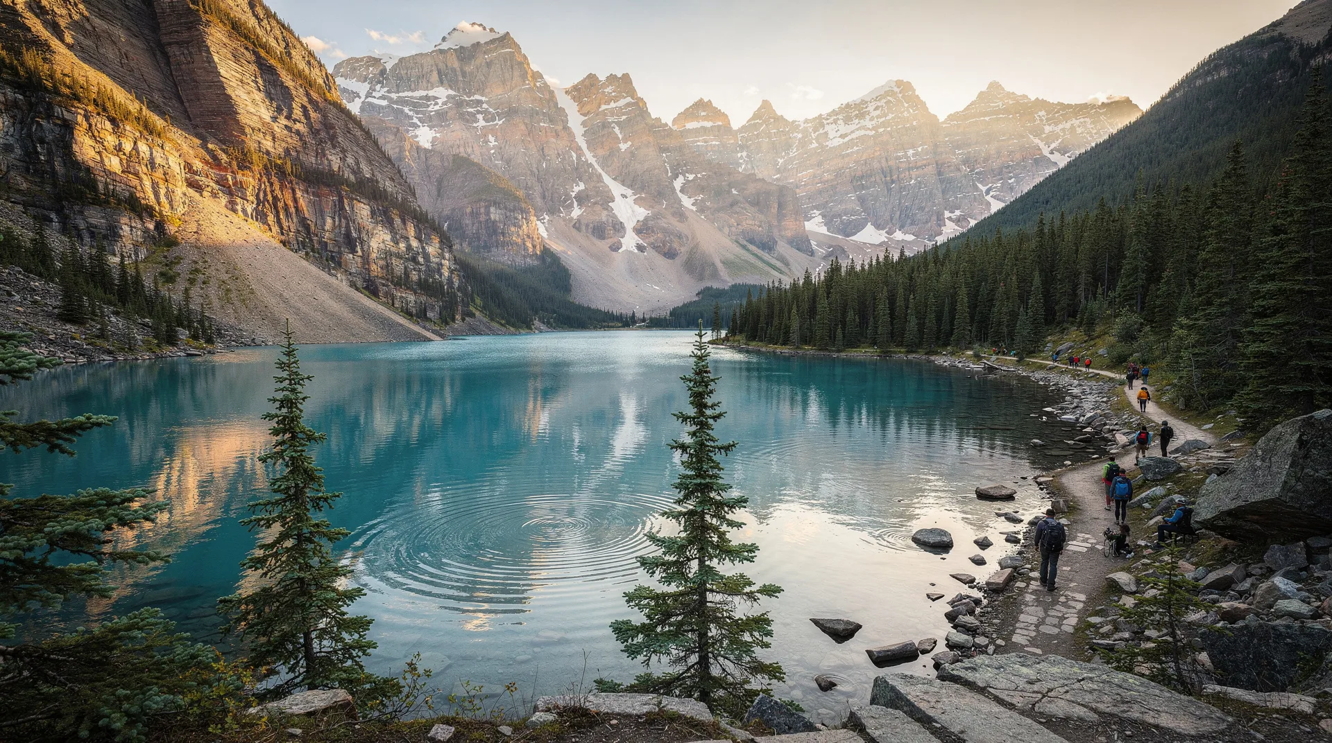
Tombstone Territorial Park is one of the most visually arresting places in Canada’s North — a landscape of black, jagged quartzite peaks rising from open tundra valleys coloured in gold, rust, and deep green depending on the season. The park covers 2,200 square kilometres along the Ogilvie Mountains, straddling the Dempster Highway roughly 71 kilometres north of the turnoff from Dawson City. Access is direct — you drive the Dempster, stop, and step into a world that looks engineered for drama.
The name comes from Tombstone Mountain itself, a pyramidal peak of ancient quartzite whose near-vertical walls and pointed summit dominate the valley visible from the Dempster. The mountain was named by early prospectors who apparently found its silhouette unsettling. Today, it is the defining image of the Yukon’s alpine interior — appearing on trail guides, regional brochures, and the mental map of anyone who has driven the Dempster and paused at the Tombstone interpretive centre to absorb what they’re looking at.
This is Tr’ondëk Hwëch’in First Nation territory, and the park reflects that relationship. The Tr’ondëk Hwëch’in people have lived in and traveled through this landscape for thousands of years; the park’s management is developed collaboratively with the Nation, and the interpretive centre in the valley communicates both the ecological significance of the area and the cultural continuity of the people whose homeland this remains.
The landscape and what makes it extraordinary
The park sits at the ecological intersection of three biomes: the boreal forest of the Yukon interior, the subarctic alpine, and the Beringian steppe — the ancient grassland ecosystem that persisted through the Ice Age on unglaciated land connecting Asia and North America. This Beringian character gives the park’s tundra a different character from alpine areas further south: the vegetation communities include plants with deep Beringian roots, and the wildlife assemblage reflects this ancient lineage.
The Ogilvie Mountains here are made of Proterozoic-era quartzite — one of the oldest rock formations in the Yukon. The dark colour of the peaks comes from iron-stained quartzite that weathers black, creating that signature silhouette against the wide sky. Glaciation carved the valleys into broad U-shapes while the peaks escaped beneath the ice surface, resulting in the dramatic contrast between the smooth valley floors and the jagged ridgelines above.
Wildlife density here is genuinely high for an alpine environment. Grizzly bears are common — park staff estimate consistent grizzly use across the valley system. Dall sheep occupy the high ridges; caribou of the Fortymile and Porcupine herds pass through on seasonal migrations; wolverines, golden eagles, Arctic ground squirrels, and ptarmigan are all regular sightings. The tundra habitat is productive in ways that temperate alpine environments often are not.
Hiking in Tombstone
The park has a handful of established trails and a much larger network of undeveloped hiking terrain accessible to experienced wilderness travellers. The interpretive trails near the Tombstone Campground are the entry point; serious hiking extends deep into the backcountry.
Goldensides trail
The most accessible significant hike in the park. From the Dempster Highway at km 73, the trail climbs steadily through stunted spruce forest before breaking into open tundra. The ridge at the top provides panoramic views of Tombstone Mountain directly across the valley, the Blackstone River below, and peaks extending north toward the Richardson Mountains. The return distance is approximately 8 kilometres, with around 550 metres of elevation gain. Conditions at the top can be cold and windy regardless of valley temperature — carry a windproof layer.
Grizzly Lake route
The Grizzly Lake area, roughly 12 kilometres from the highway by established trail, is the benchmark overnight experience in the park. The trail crosses open tundra following the North Klondike River valley, with steady views of Tombstone Mountain and the surrounding peaks. Camping at Grizzly Lake requires registration and bear canister use (mandatory in the park). The lake itself sits in a cirque beneath high ridges with excellent grizzly bear activity — hence the name and the requirement for proper bear awareness throughout.
Mount Monolith traverse
For experienced alpine hikers, the Mount Monolith area north of the campground provides more demanding terrain with extraordinary views. This is trackless alpine travel — there is no maintained trail, and navigation requires map and compass competence alongside route-finding ability on loose quartzite. The payoff is access to a landscape of cirque lakes, snow-filled couloirs, and 360-degree views from the ridge systems that few visitors reach.
Divide Lake
Accessible from the Dempster at a different trailhead, Divide Lake sits near the Arctic Circle-adjacent terrain of the park’s northern reaches. The hike passes through characteristic Beringian tundra — open, rolling country with long sightlines that makes wildlife spotting both easier and more humbling. The scale of the landscape here reminds you that this is a small park in an enormous wilderness.
Practical realities: access, cost, and conditions
Tombstone is a Yukon territorial park with no entry fee, which makes it unusual among significant protected areas in northern Canada. Registration is required for overnight backcountry travel, available at the Tombstone Interpretive Centre at km 71.
The interpretive centre is the essential first stop. Park staff here can update you on trail conditions, wildlife activity (including current grizzly locations), river crossing levels, and weather forecasts. In a park where conditions change rapidly and wildlife encounters are genuine rather than theatrical, this information matters.
Getting there: From Dawson City, the Dempster Highway turnoff is 40 kilometres east of town on the Klondike Highway. The Tombstone Interpretive Centre is a further 71 kilometres north on the Dempster — a gravel road that requires a spare tire (or two). Drive slowly through the dust and loose gravel, and check the tire situation before departing. A 4WD vehicle is not required, but a vehicle with good clearance and solid tires is.
Accommodation: The Tombstone Campground (km 71.5) provides the main camping, with sites suited to both tents and RVs. Services are limited — outhouses and water available, no hookups. In the backcountry, designated camping zones are identified in park planning materials. Wild camping away from designated sites requires careful site selection and strict Leave No Trace practice.
Season: The park’s upper trails are typically passable from late July through mid-September. Early July can mean significant snowpack on north-facing slopes and high passes. By late September, early snow becomes possible and the trails are increasingly difficult. The September tundra colour — crimson bearberry, amber sedge, gold willow — is one of the Yukon’s signature visual experiences, and this timing draws dedicated photographers willing to accept deteriorating weather odds.
Bear safety: The park has one of the highest grizzly bear densities in the Yukon. Bear spray is mandatory for backcountry travel and should be carried accessible (not in your pack) at all times. Bear canisters are required for food storage in backcountry camping zones. Make noise on trail, particularly in dense shrub areas or when approaching stream crossings where visibility is reduced.
Browse Yukon wilderness hiking and adventure tours including Dempster Highway experiencesWildlife watching
Grizzly bears are the apex attraction. The park’s tundra landscape means sightings are frequent — you can often watch bears feeding on berries or digging for ground squirrels from a considerable distance, which is the ideal way to watch grizzlies. Binoculars are essential; getting close is not the goal.
Dall sheep appear on the high ridgelines, particularly on Gravel Lake Mountain and the ridges above the Grizzly Lake area. They are usually visible as white dots against grey quartzite — patience and optics will resolve them into full animals. The rams travel in bachelor groups in summer; ewes with lambs stay at higher elevations.
Golden eagles nest in the park and soar the thermals above the valley throughout summer. Peregrine falcons occupy cliff faces on the main valley walls. Arctic grayling fishing in the North Klondike River is productive for those with a Yukon fishing licence.
Photography in Tombstone
Few landscapes in Canada offer this combination of dramatic peak geometry, wide tundra framing, and extraordinary light. The mountain plateau location means long “golden hours” in summer — the sun stays low on the horizon well into the evening, and the quality of light on the black quartzite peaks is repeatedly spectacular.
For the classic Tombstone Mountain composition, position yourself on the valley floor or the lower Goldensides slope with the peak framed to the northwest. Morning light hits the peak first; evening light provides warm colour on the quartzite.
September tundra colour is the second major photographic draw. The bearberry turns crimson in late August and deepens through September; combined with the jagged peaks and the open sky, it produces the images that represent the Yukon in a certain kind of wilderness photography.
Book photography and wildlife tours from Whitehorse into the Yukon interiorRelated destinations
Tombstone sits along the Dempster Highway, which continues north to Inuvik and ultimately to Tuktoyaktuk on the Arctic Ocean. Most visitors pair Tombstone with time in Dawson City — the historic gold rush town 71 kilometres south is an excellent base for Dempster exploration. Haines Junction and Kluane National Park in the southwest Yukon offer a different character of alpine wilderness for those making a circuit of the territory. For a full Yukon trip, consider the 7-day Yukon itinerary that incorporates Whitehorse, Dawson City, and the Dempster corridor.
Frequently asked questions about Tombstone Territorial Park: The Yukon’s Alpine Wonder
Do I need a permit to hike in Tombstone? Day hiking on the main trails does not require a permit. Overnight backcountry travel requires registration at the Tombstone Interpretive Centre and adherence to designated camping zones. The registration process takes 15–20 minutes and provides essential safety information.
Can I drive the Dempster in a regular car? Yes, but with preparation. A spare tire (ideally two) is essential — the gravel surface produces flat tires regularly. Check tire condition before departure and travel at reasonable speeds. Most rental car agreements prohibit driving on unpaved roads; check your rental terms and consider renting from a Dawson City operator who explicitly covers the Dempster.
What are the chances of seeing a grizzly bear? Higher than almost anywhere else accessible by road in Canada. In a 2–3 day visit during summer or early fall, most visitors who spend time hiking the trail network see at least one grizzly. Bears here are habituated to the landscape, not to people — maintain distance and make noise.
When is the best time for autumn colour? Late August through mid-September. The bearberry tundra turns crimson from late August; peak colour across the valley is typically in the first two weeks of September. Weather in September is increasingly unpredictable — prepare for cold nights and potential early snow.