Quick facts
- Length
- 1,738 km (Great Slave Lake to Arctic Ocean)
- Basin area
- 1.8 million km² — 20% of Canada
- Communities along route
- Fort Providence, Fort Simpson, Norman Wells, Tulita, Fort Good Hope, Inuvik
- Main season
- Mid-June to early September
The Mackenzie River is Canada’s longest and one of the largest rivers in the world by discharge. Flowing 1,738 kilometres from Great Slave Lake to the Beaufort Sea, it drains a basin of 1.8 million square kilometres — roughly 20% of Canada’s total land area. For the Dene and Gwich’in peoples of the Northwest Territories, the river has been the central artery of life for at least 10,000 years; for travellers today, it offers one of the most significant wilderness river journeys available anywhere.
This is not a casual destination. The Mackenzie demands respect — long distances, remote communities, sudden weather, and logistics that require genuine planning. But for travellers prepared to engage with it on its terms, the Mackenzie is one of the great experiences of Canadian travel.
The river in context
The Mackenzie proper runs from the outlet of Great Slave Lake at Fort Providence to the Arctic Ocean east of the Mackenzie Delta. The water in the river, however, originates much further afield — the Peace River rises in British Columbia’s Rocky Mountains, flows east across Alberta to meet the Athabasca River in Lake Athabasca, and thence via the Slave River to Great Slave Lake and out into the Mackenzie. The total distance from headwater to sea is 4,241 kilometres, making the Mackenzie system the second-longest river system in North America after the Mississippi–Missouri.
The river is known to Dene speakers as Dehcho, meaning “big river.” Sir Alexander Mackenzie, the Scottish-Canadian fur trader, descended the river to the Arctic Ocean in 1789 — the first non-Indigenous person known to have done so. He named it “River of Disappointment” because it flowed north to the Arctic rather than west to the Pacific he was seeking. The geographic error was corrected; the name was not.
The landscape
The Mackenzie passes through several distinct landscapes over its length.
Upper river (Fort Providence to Fort Simpson). Wide, calm water across the southern NWT plains. Boreal forest of spruce and poplar on the banks. Occasional rocky outcrops.
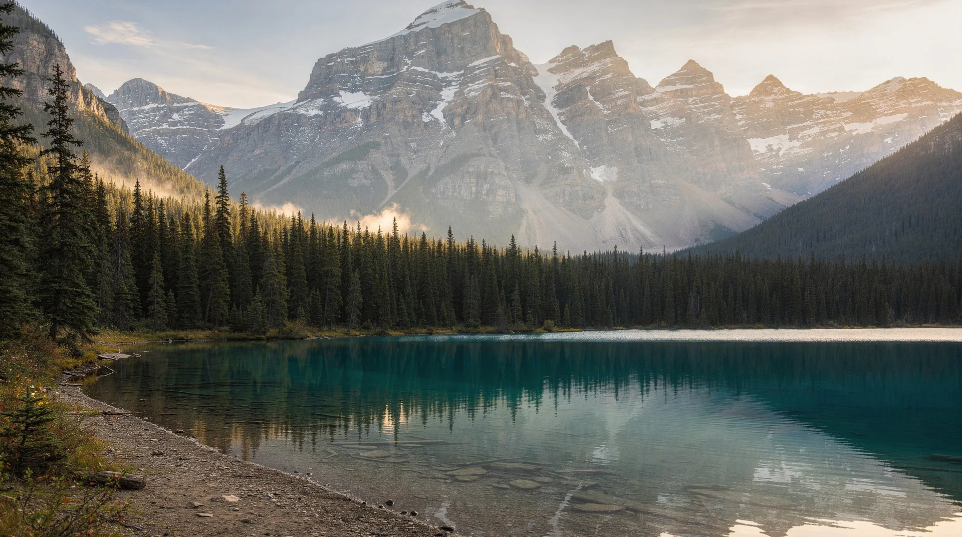
Middle river (Fort Simpson to Norman Wells). The river valley narrows. The Mackenzie Mountains rise to the west. The Ramparts — spectacular limestone cliffs — line the river for kilometres below Fort Good Hope. This is the most scenically varied stretch.
Lower river (Norman Wells to the Delta). The river widens again, islands proliferate, and the water carries increasing glacial sediment from tributaries. The Beaufort Sea becomes the ultimate destination.
The Delta (below Inuvik). The Mackenzie breaks into a vast network of channels and lakes covering 12,000 square kilometres — one of the largest Arctic deltas in the world. Access from here to Tuktoyaktuk and the Beaufort coast is via numerous routes.
Trip options
The Mackenzie can be approached in several distinct ways, depending on time, budget, and experience.
Full descent (Fort Providence to Inuvik)
The classic expedition: 1,738 kilometres, 4–6 weeks of paddling, full wilderness immersion with resupply in Fort Simpson, Wrigley, Norman Wells, and Fort Good Hope.
Experience. For expert paddlers only. Real wilderness remoteness — days between potential assistance. Satellite communication essential. Fall-back evacuation logistics need pre-arrangement.
Guided options. A handful of operators run guided full-descent trips, though not every year. Check with Northern Soul Wilderness Adventures and similar northern outfitters.
Fort Simpson to Norman Wells (Middle Section)
The most scenically rewarding single-section trip. Approximately 500 kilometres. 10–14 days. Includes the Ramparts and the most dramatic mountain scenery.
Access. Fort Simpson is accessible by highway (summer only) or air; Norman Wells is accessible by scheduled flight.
Shorter segments
- Fort Providence to Fort Simpson. About 350 km, 7–10 days.
- Norman Wells to Fort Good Hope. About 300 km, 7 days.
- Fort Good Hope to Inuvik. About 500 km, 10–14 days.
Guided day and multi-day trips
For travellers who want to experience the river without the full expedition commitment, day and multi-day guided trips operate from Fort Simpson, Norman Wells, and Inuvik. These typically focus on a 1–3 day section and include full equipment and logistics.
Commercial river tours
The MV Norweta occasionally offers river cruising on sections of the Mackenzie — though availability has been intermittent. This is the only non-paddling option for experiencing the river over distance.
Communities along the river
The Mackenzie is not a wilderness without people. A string of Indigenous communities — most Dene, some Gwich’in in the lower river — line the route. Respectful engagement with these communities is part of a meaningful Mackenzie trip.
Fort Providence (pop. ~750). Dehcho Dene community near the river’s head. Access to the Deh Cho Bridge and the NWT highway system.
Fort Simpson (pop. ~1,200). Larger community at the junction with the Liard River. Services, accommodation, Parks Canada presence (for Nahanni National Park access). A major trip terminus.
Wrigley (pop. ~130). Small Dene community. End of the road network; further travel is by air or river.
Tulita (pop. ~480). Sahtu Dene community. Historically called Fort Norman. Significant cultural centre.
Norman Wells (pop. ~800). Resource-industry town with significant tourism infrastructure. Historic Imperial Oil connection. Jumping-off point for Canol Heritage Trail.
Fort Good Hope (pop. ~560). Dene community with the notable Our Lady of Good Hope church — an exceptional 19th-century wooden building with elaborate painted interior.
Tsiigehtchic (pop. ~160). Gwich’in community at the confluence with the Arctic Red River.
Inuvik (pop. ~3,400). The regional hub of the western Arctic, access point for the Mackenzie Delta, Tuktoyaktuk, and the Dempster Highway.
Cultural protocol
Travellers on the Mackenzie are passing through Dene and Gwich’in territory, often with limited prior briefing or local knowledge. Key points:
- Stop at communities to introduce yourself — not necessarily for every river party, but particularly if you are planning to camp nearby or require any services.
- Respect fishing nets and other Indigenous harvesting equipment; never disturb nets or caches.
- Purchases from community stores support local communities; plan to resupply where possible.
- Some areas along the river have cultural significance that may not be obvious to visitors. Local advice at communities is valuable.
- Photography of people and homes requires consent.
Wildlife
The Mackenzie is a wildlife-rich river.
Moose. Abundant throughout the river’s length. Black bear. Common, particularly on the middle and lower river. Grizzly bear. Present on the lower river and in the mountain zones. Wolves. Regularly heard at night; occasionally seen from the water. Bald eagles. Common. Peregrine falcons. Nest on the Ramparts cliffs. Beluga whales. In the Beaufort Sea at the river’s mouth; occasionally enter the lower river in summer. Fish. Northern pike, lake trout, arctic grayling, inconnu (sheefish), and — in the lower river — Arctic char.
Practical trip planning
Essential preparation
- Satellite communication device (InReach or similar). Not optional.
- Multi-day wilderness first aid training for at least one party member
- Comprehensive trip plan filed with NWT authorities and family
- Appropriate boat (tandem canoe, double kayak, or expedition sea kayak)
- Full wilderness camping gear rated for the coldest temperatures you might encounter
- Bear-resistant food storage
- Full set of river-appropriate clothing including cold-water immersion gear
When to go
Mid-June to early July. Ice has cleared. Water is often high from snowmelt. Mosquitoes and blackflies are at their worst.
Late July to mid-August. Peak paddling season. Warm days, long daylight, moderate insects, stable weather.
Late August to early September. Cooler; first frosts; leaves turning. Insects diminish. Weather windows tighten.
After mid-September. Freeze-up risk increases. Not recommended for long trips without local knowledge.
Costs
Self-guided trip. Primary costs are flights to starting points and home from end points (often expensive), rental of boats and equipment (if not your own), satellite device, and food. A 2-week trip with flights typically runs CAD $4,000–$7,000 per person.
Guided trip. CAD $800–$1,500 per person per day for fully guided multi-day trips.
Permits
Generally no permits are required for river travel, though some stretches within protected areas (Nahanni National Park Reserve) do require permits for camping. Check with NWT Parks and Parks Canada for your specific itinerary.
For travellers not paddling
The Mackenzie is not only for paddlers. Ways to experience the river without an expedition:
- Visit Fort Simpson or Norman Wells. Both are accessible by flight and offer accommodation and shorter boat trips.
- Fly over the river. Scheduled commercial flights between southern NWT and Inuvik cross the entire length. Window seats on clear days deliver remarkable views.
- Day boat tours from Inuvik. Mackenzie Delta tours operate in summer — much more accessible than river expeditions.
- Drive the Dempster Highway. Crosses the river via ferry (summer) or ice crossing (winter) near Tsiigehtchic.
Related reading
- Dempster Highway
- Nahanni National Park Reserve
- Yellowknife
- Inuvik
- Northwest Territories
- Canada in August
The Mackenzie is an exceptional river. For the right traveller — prepared, experienced, and willing to engage deeply with both the landscape and the Indigenous peoples who have shaped it — a Mackenzie trip is one of the defining journeys available in North America. For others, even seeing the river briefly from a community along its course provides a meaningful brush with Canada’s most significant northern waterway.