Quick facts
- Population
- 45,000
- Best time
- Aug–Mar (aurora); Jun–Aug (summer wilderness)
- Languages
- English, French, Dene languages, Inuktitut
- Days needed
- 5-10 days
There is a moment that every first-time visitor to Yellowknife describes in the same way: stepping outside on a clear winter evening and seeing the sky come alive with curtains of green light, shifting and folding in silence above a frozen lake that extends to the horizon in every direction. The Northwest Territories has been selling itself as Canada’s aurora capital for decades, and it is not an exaggeration. Yellowknife sits at 62.5° North latitude, directly beneath the auroral oval, and its dry continental climate produces the cloud-free skies essential for viewing with a reliability that coastal aurora destinations cannot match.
But the Northwest Territories is far more than its aurora. Covering 1.35 million square kilometres — larger than Egypt — the territory contains some of the most extraordinary wilderness landscapes in North America: the Nahanni River and its Virginia Falls (nearly twice the height of Niagara), the bison herds of Wood Buffalo National Park (the largest in the world), the 614-kilometre Mackenzie River emptying into the Beaufort Sea, the Great Slave Lake (the deepest lake in North America at 614 metres), and a living Dene culture that has inhabited this land for thousands of years and today maintains a strong presence in the territory’s governance and daily life.
Yellowknife: the aurora capital of Canada
Yellowknife, population approximately 22,000, is the capital of the Northwest Territories and the starting point for virtually every visit to the territory. It is a genuine northern city — not a tourist outpost, but a functioning government and resource-industry hub with good restaurants, a lively arts scene, a hockey-obsessed community, and the distinct culture that emerges when people choose to live in a place where winter temperatures regularly reach -40°C.
The city sits on the northern shore of Great Slave Lake, and much of its character comes from the lake’s presence. In summer, Yellowknifers are on the water — boating, fishing, swimming in the shallower bays that warm up enough by July. In winter, the lake freezes to 1–2 metres of solid ice, and an ice road connects Yellowknife to communities to the north that are otherwise accessible only by air. The sight of trucks driving across dozens of kilometres of frozen lake, their lights visible in the midwinter darkness, is one of the territory’s peculiar and memorable images.
The aurora from Yellowknife
The aurora viewing season in Yellowknife runs from late August through April — roughly coinciding with when the sky gets dark enough to show the lights. Peak viewing probability falls in February and March, when the nights are longest and atmospheric conditions are most stable, but exceptional displays occur throughout the season.
Browse Canada northern lights and aurora viewing experiencesMultiple tour operators run aurora viewing excursions from the city, transporting guests to heated teepees, cabins, or warming huts on frozen lakes outside the city’s light pollution. The best operators provide photography guidance, local food and drinks during the wait, and interpretation of the aurora’s significance in Dene and other northern Indigenous traditions. Japanese visitors — for whom a winter aurora tour in Yellowknife has become something of a bucket-list item — make up a significant portion of the winter visitor base, and many operators have multilingual guides.
The aurora is also visible from the city itself on strong nights — the road to the ice road, the shores of Frame Lake in the middle of the city, and the rocky escarpment in Old Town all offer reasonable dark-sky conditions within walking distance of downtown hotels.
Old Town Yellowknife
The original settlement of Yellowknife, known as Old Town, clusters on a rocky peninsula jutting into Great Slave Lake north of the main city. This is where the gold miners who founded Yellowknife’s economy built their first cabins; many of those cabins survive, along with a collection of float planes on Yellowknife Bay (the city’s float plane base is one of the busiest in Canada) and the Wildcat Café, a heritage log structure that has been serving food since the gold rush era.
Old Town’s waterfront at sunset, with float planes moored at the dock and the lake stretching south to the horizon, is one of the more evocative scenes in the Canadian north. The Northern Arts and Cultural Centre (NACC) presents northern theatre, music, and visual art year-round, with a program that includes significant Indigenous content.
The Prince of Wales Northern Heritage Centre
The territory’s primary museum, located in downtown Yellowknife, houses comprehensive collections covering northern natural history, Indigenous cultures of the NWT, and the history of exploration and resource development. The Dene and Inuit collections are particularly strong — the tools, clothing, and ceremonial objects displayed here represent living cultures, and the museum’s interpretive approach reflects this by centering Indigenous voices in the interpretation. Allow at least three hours.
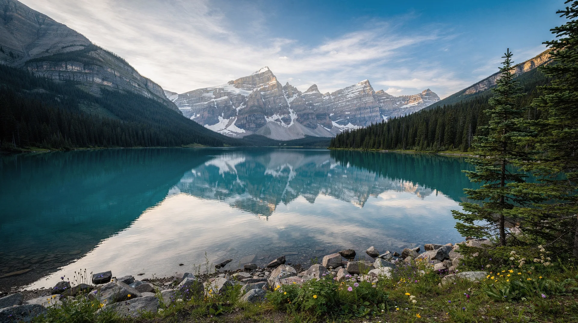
Nahanni National Park Reserve and Virginia Falls
Nahanni is the name that wildlife photographers, wilderness paddlers, and Parks Canada enthusiasts cite when asked to name the most extraordinary national park in Canada. The South Nahanni River cuts through a series of deep canyons — First Canyon, Third Canyon, The Gate — in the Mackenzie Mountains of the southwestern NWT, descending over Virginia Falls (a 96-metre drop across a width greater than Niagara) before emptying into the Liard River. The entire system is a UNESCO World Heritage Site, one of the first designated (1978) and one of the most unconditional in its wilderness character.
Virginia Falls itself — Náilicho in Dene Zhie — is the centrepiece. At 96 metres in height (compared to Niagara’s 57-metre Horseshoe Falls) and considerably wider than that comparison suggests, it is Canada’s most spectacular waterfall and among the most dramatic in North America. The spray plume is visible from several kilometres away; the roar of the falls can be heard from the camp at the top of the approach trail. Standing at the canyon rim looking down at the full drop is an experience that leaves most visitors temporarily speechless.
Nahanni is accessible only by floatplane from Fort Simpson, Watson Lake, or Yellowknife — there are no roads. The classic Nahanni River journey is a 550-kilometre canoe or raft descent from Rabbitkettle Lake to Blackstone Territorial Park, taking 10 to 21 days and requiring advanced whitewater skills on sections of the river. Guided commercial trips run throughout the summer season; non-guided groups need Parks Canada permits booked months in advance.
For those without the time or experience for a full river journey, floatplane day trips to Virginia Falls are available from operators in Fort Simpson and, with longer flight distances, from Yellowknife. The day trip option provides access to the falls and the canyon rim without the full wilderness commitment.
Wood Buffalo National Park
Wood Buffalo National Park straddles the border between the Northwest Territories and northern Alberta, covering 44,807 square kilometres — larger than Switzerland, larger than any other national park in Canada, and a UNESCO World Heritage Site. It was established in 1922 specifically to protect the last wild herd of wood bison in the world; the park today supports a free-roaming bison herd of approximately 5,000 animals, the largest in existence.
The park contains the last remaining whooping crane nesting habitat in the world. The species was reduced to 16 individuals in 1941; conservation efforts centred on the Wood Buffalo nesting grounds have brought the wild population to over 500. Observing whooping cranes in the park during summer requires special permits and is one of the most exclusive wildlife experiences in Canada.
Beyond bison and cranes, Wood Buffalo contains the world’s largest beaver dam (visible via satellite imagery at 850 metres in length), extensive salt plains at the Peace-Athabasca Delta (a Ramsar Wetland of International Importance), and river valleys populated by wolves, black bears, lynx, and river otters. Fort Smith, on the NWT-Alberta border, serves as the main gateway.
The Mackenzie River and the Dene
The Mackenzie River — Deh Cho in the Dene languages, meaning Big River — is the longest river in Canada at 1,738 kilometres from its headwaters in Great Slave Lake to its delta on the Beaufort Sea. It drains an area of 1.8 million square kilometres, the second-largest drainage basin in North America after the Mississippi. Along its length lie the communities of the Dene peoples — the Dehcho, Tlicho, Sahtuto’ine, Aklavik — who have lived in relationship with the river for thousands of years.
The Dene Nation comprises the Indigenous peoples of the NWT’s boreal and subarctic lands. Their presence is foundational to the territory’s identity: approximately half of the NWT’s population is Indigenous, with Dene peoples representing the largest group. Dene governance structures, land rights, and cultural programming are woven into the territory’s political and social fabric in ways that have no parallel in most southern Canadian jurisdictions. Visitors to Yellowknife encounter this immediately — Indigenous businesses, art, governance bodies, and cultural events are a visible and central part of city life.
Visiting Dene communities along the Mackenzie is possible and, approached respectfully, enormously enriching. Hay River (on Great Slave Lake), Fort Providence, Fort Simpson, Tulita, Norman Wells, and Inuvik each have their own character and welcome visitors who engage thoughtfully. Community tourism initiatives exist in several of these towns; contact the NWT Tourism office in Yellowknife for current programming.
Great Slave Lake and summer fishing
At 27,200 square kilometres, Great Slave Lake is the deepest lake in North America (614 metres) and the tenth largest in the world. Its cold, clear waters support exceptional populations of lake trout — fish of over 20 kilograms are caught regularly — along with northern pike, arctic grayling, walleye, and whitefish. Sport fishing on Great Slave Lake draws dedicated anglers from across North America who arrive in July and August for the peak season.
Fishing lodges on the lake’s East Arm and around the town of Hay River operate through the summer season, typically offering all-inclusive packages with accommodation, guiding, and licences. The East Arm of the lake — a rugged, island-studded wilderness of Precambrian rock and clear water — is particularly prized for trophy lake trout and its scenery.
Beyond fishing, the lake is used in summer for kayaking and canoeing — particularly in the East Arm and around the archipelago of islands near Yellowknife. The remarkable clarity of the water in the northern sections allows visibility to remarkable depths.
Getting to and around the Northwest Territories
Yellowknife is served by Air Canada and Canadian North with regular flights from Edmonton (approximately 2 hours). WestJet serves Yellowknife seasonally. Connections from Calgary, Winnipeg, and Vancouver involve a stop in Edmonton. There are no road connections to Yellowknife from the south in summer; the city is accessible by road only via the Mackenzie Highway and, in winter, the ice road across Great Slave Lake.
Once in Yellowknife, a rental vehicle provides access to the city and the immediate surrounding area. Most wilderness destinations — Nahanni, Wood Buffalo, and communities along the Mackenzie — require either charter aircraft or very long drives. The territory’s road network covers roughly 4,000 kilometres of paved and gravel roads, including the Mackenzie Highway from Alberta to Fort Simpson and Fort Providence, the highway to Inuvik via the Dempster Highway connection through the Yukon, and secondary roads to various communities.
Travel in the Northwest Territories requires realistic planning around the territory’s remoteness. Medical facilities are concentrated in Yellowknife; smaller communities have nursing stations. Emergency evacuation is available but expensive — comprehensive travel insurance covering medical evacuation is not optional.
When to visit the Northwest Territories
August to September: The aurora becomes visible again as nights lengthen after the summer solstice. August offers warm temperatures (15–20°C), active wildlife, and the first reliable aurora viewing of the season. September brings fall colours, cooler temperatures, and increasingly clear skies.
January to March: The prime aurora season. Cold (Yellowknife averages -27°C in January) but clear, with the longest dark windows for viewing. Dog sledding, snowshoeing, and ice fishing are all active. This is the peak season for Japanese and European aurora tourists.
June to July: Summer wilderness season. Midnight sun arrives (Yellowknife has 24-hour daylight around the solstice). Fishing is prime, Nahanni paddling is at its best, and biting insects (blackflies and mosquitoes) are at their most intense — effective insect repellent is not optional in the boreal summer.
October to November: Transition between seasons. Snow arrives, freeze-up begins on lakes and rivers, aurora probability increases. This is a quieter period with fewer tourists and increasingly dramatic light.
Frequently asked questions about Northwest Territories
How cold does Yellowknife get in winter? Average daily temperatures in January range from -22°C to -32°C, with extreme cold snaps reaching -45°C or below. This is not unusual for residents and is manageable for visitors with appropriate clothing — layered merino wool base layers, insulated mid-layer, and a wind-proof outer shell rated to -40°C. Exposed skin freezes quickly at these temperatures; face coverage is essential.
Is Yellowknife safe to visit? Yes. Like any northern Canadian city, Yellowknife has normal urban safety considerations, particularly downtown on weekend evenings. The territory’s social challenges associated with remote resource-industry economies are present but do not affect visitor safety in any meaningful way. Standard urban awareness applies.
Can I see Wood Buffalo bison on a casual drive? Bison are commonly seen along the roads in and around the park, particularly in the Peace-Athabasca Delta area. Sightings are not guaranteed but the probability on a full day drive through the park in summer is good. Do not approach bison on foot — they are large, fast, and unpredictable animals.