Quick facts
- Area
- 21,980 km²
- UNESCO status
- World Heritage Site (with Wrangell-St. Elias)
- Mount Logan
- 5,959 m — Canada's highest peak
- Best months
- Mid-June to early September
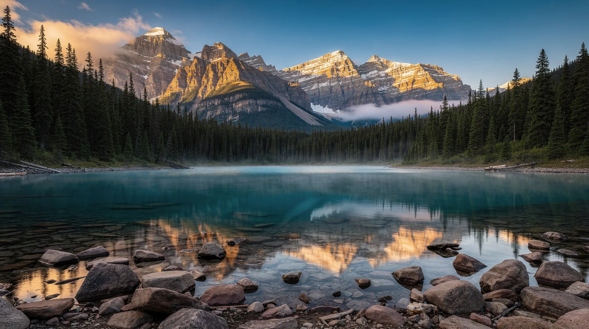
Kluane National Park and Reserve covers 21,980 square kilometres of the southwest Yukon — an area roughly the size of Israel. It contains Canada’s highest mountain (Mount Logan at 5,959 metres), the world’s largest non-polar icefield (the Kluane Icefield), North America’s biggest grizzly bear density, and some of the most dramatic mountain landscapes on the continent. Together with the adjacent Wrangell-St. Elias in Alaska and Tatshenshini-Alsek in British Columbia, Kluane forms a UNESCO World Heritage Site covering the largest internationally protected area on earth.
Most visitors experience Kluane from the eastern edge — the Alaska Highway corridor and the village of Haines Junction, where roads access small sections of an otherwise immense wilderness. The core of the park, including Mount Logan and the major icefields, is accessible only by aircraft. For a traveller in the Yukon, even a single day in Kluane’s accessible zone delivers mountain scenery and wildlife that match or exceed anything in the Rocky Mountain parks.
The landscape
Kluane is defined by its mountains and ice. The St. Elias Mountains run through the park — Canada’s highest and most heavily glaciated range. Mount Logan at 5,959 metres is the second-highest peak in North America after Denali; the Logan massif alone covers more area than many mid-sized national parks elsewhere in the world.
The ice is extraordinary. The Kluane Icefield feeds major glaciers in every direction: the Kaskawulsh, Hubbard, Logan, Steele, and dozens more. Some glaciers flow tens of kilometres from their accumulation zones. The Hubbard Glacier, flowing toward the Gulf of Alaska outside the park boundary, is one of the most famous tidewater glaciers in the world.
At lower elevations, the park descends through subalpine forest, tundra, and lake valleys. Kluane Lake — the largest in Yukon, visible from the Alaska Highway — occupies a glacially carved basin just outside the park boundary.
Haines Junction and the eastern approach
Haines Junction, a small village at the intersection of the Alaska Highway and the Haines Road, is the main visitor hub for the park. Services include:
- Kluane National Park Visitor Centre (Parks Canada)
- Da Kų Cultural Centre (Champagne and Aishihik First Nations)
- Accommodation (several hotels, motels, B&Bs)
- Restaurants and grocery
- Outfitters and guide services
The visitor centre is the essential starting point. Staff provide current trail and wildlife conditions, issue backcountry permits, and offer orientation to the park’s layout and access points. Exhibits cover the mountains, glaciers, and Indigenous cultural history.
Main viewpoints and short walks
Several short, accessible trails and viewpoints provide a strong Kluane experience without backcountry commitment.
Kluane Lake. The 400 square kilometre lake is visible along a long stretch of the Alaska Highway. Several pull-offs offer viewpoints; the southern shore (Destruction Bay) has wayside stops with interpretation.
Soldier’s Summit. Short trail climbing above the Alaska Highway north of Haines Junction. Panoramic views of the St. Elias range.
Kings Throne Route. 10 km round trip with substantial elevation gain (1,100 m) to a cirque beneath Kings Throne peak. One of the best day hikes in southern Yukon. Difficult but rewarding.
St. Elias Lake Trail. 7 km round trip (relatively easy) to a small lake with mountain views.
Rock Glacier Trail. 1 km interpretive trail to an active rock glacier — a tongue of ice-cored debris that slowly flows downhill.
Dezadeash River Loop. 5 km easy walk near Haines Junction.
Longer hiking and backcountry
Multi-day hikes deliver the core Kluane experience.
Slims West. 45 km return to the Kaskawulsh Glacier. 3–4 days. One of North America’s great hikes. Views along the route include the Kluane icefields, wildlife possibilities (grizzly, moose), and the dramatic toe of the Kaskawulsh.
Cottonwood Trail. 85 km loop, 5–7 days. Challenging but rewarding traverse through varied terrain.
Auriol Trail. 15 km loop, 1–2 days. More accessible backpacking option.
Backcountry camping requires a permit from the Parks Canada visitor centre. Bear-resistant food storage is mandatory. All hikers must attend a bear safety briefing; rentals of bear-resistant canisters are available.
Flightseeing
For visitors who want to experience the icefields and high mountains without multi-day backcountry travel, flightseeing is the primary option — and it is extraordinary.
Operators. Several fixed-wing operators run flights from Haines Junction and from a strip near Silver City on the Alaska Highway. Trans North Aviation and Sifton Air are among the main operators.
Flight options.
- Icefield flight (60–90 minutes). Overflies the Kluane Icefield and a selection of major glaciers. Often includes Mount Logan flyby.
- Glacier landing (2–3 hours). Lands on a glacier surface for 15–30 minutes on the ice. One of the signature Yukon experiences.
- Extended tour (2–3 hours). Deeper penetration into the park with landings at remote locations.
Cost. CAD $350–$800 per person depending on tour type.
Weather dependent. Cloud cover over the mountains frequently cancels or modifies flights. Allow flexibility; do not book flightseeing on your departure day.
Wildlife
Kluane is one of the best wildlife viewing parks in Yukon.
Grizzly bears. One of the highest densities in Canada. Sightings possible on many hikes and from the Alaska Highway corridor. Standard bear safety essential.
Dall sheep. Distinctive white-coated mountain sheep. Regularly visible on slopes visible from the Alaska Highway, particularly around Sheep Mountain.
Mountain goats. Present but less visible than Dall sheep.
Moose. Common in lower-elevation wetlands.
Black bear. Also present.
Wolves. Heard more than seen; occasional sightings at dawn and dusk.
Eagles. Bald and golden both present.
Hoary marmots. Alpine specialists, visible on rock slopes above treeline.
The Champagne and Aishihik First Nations
Kluane National Park lies on the traditional territory of the Champagne and Aishihik First Nations and Kluane First Nation. The Da Kų Cultural Centre in Haines Junction — operated by the Champagne and Aishihik — offers exceptional Indigenous cultural programming including exhibits, language programmes, and cultural demonstrations. Visit the centre alongside the Parks Canada visitor centre for a fuller understanding of the park and its context.
When to visit
Mid-June. Early summer. Trails may still have snow at higher elevations. Wildflowers beginning. Mosquitoes can be significant.
July to mid-August. Peak season. All trails accessible; all services operating; reliable flightseeing weather (relatively). Long daylight.
Mid-August to mid-September. Excellent conditions. Cooling; insects diminishing; aspens and birches colouring in early September.
Late September onwards. First snow at elevation. Trails become less accessible. Most services winding down.
Winter. The park remains open but largely transitions to a backcountry ski/snowshoe environment. Services in Haines Junction are limited. Aurora visible in winter months.
Getting there
From Whitehorse
The most common approach. Drive west on the Alaska Highway 160 kilometres to Haines Junction — approximately 2 hours. The drive itself includes significant mountain scenery.
From Skagway or Alaska
The Haines Road climbs from Haines, Alaska over the Chilkat Pass to Haines Junction. Approximately 4 hours, crossing a major national border (CDN/US).
Getting around in the park
The Alaska Highway and Haines Road define the road-accessible edge of the park. A rental vehicle is essential. No transit service.
Accommodation
In Haines Junction. Several hotels and motels, a few B&Bs, restaurants. Limited but adequate for park-focused visits.
In Kluane-adjacent areas. Several wilderness lodges and campgrounds along Kluane Lake (Destruction Bay) and the Alaska Highway corridor.
Campgrounds. Parks Canada operates a limited number of front-country sites. Yukon Parks operates additional campgrounds nearby.
Book 2–4 months ahead for peak summer weeks.
Related reading
Kluane is the kind of park where the physical scale of the landscape becomes genuinely disorienting. Standing at a viewpoint and realising that the wall of mountains you are looking at is more than 100 kilometres away, and that beyond them lies an unbroken expanse of ice larger than many European countries — this is a Yukon that does not exist anywhere further south. A day in Kluane is a day that stays with travellers for decades.