Quick facts
- Population
- ~800
- Distance from Whitehorse
- 160km west via Alaska Highway
- Best time
- June to September
- Days needed
- 2-4 days
- Kluane National Park
- Adjacent — UNESCO World Heritage Site
Haines Junction is a small town of around 800 people at the junction of the Alaska Highway and the Haines Road — the route connecting the Yukon interior to the Alaska Panhandle port of Haines. What it lacks in size, it compensates for in location: the town sits at the edge of Kluane National Park and Reserve, one of the largest protected wilderness areas in the world, where the mountains that form the St. Elias range rise to elevations above 5,000 metres and glaciers extend for hundreds of kilometres.
This is Champagne and Aishihik First Nations territory, and the community reflects that — the Da Kų Cultural Centre in Haines Junction tells the story of the Southern Tutchone people who have inhabited this landscape for thousands of years, navigating both the harsh subarctic environment and the changes brought by the Klondike Gold Rush and the Alaska Highway construction.
For travellers, Haines Junction occupies an ideal position: it has enough infrastructure to be a practical base (gas, food, accommodation, gear services), it sits directly adjacent to one of the most extraordinary wilderness parks in North America, and it can be reached in two hours from Whitehorse on a paved highway.
Kluane National Park and Reserve
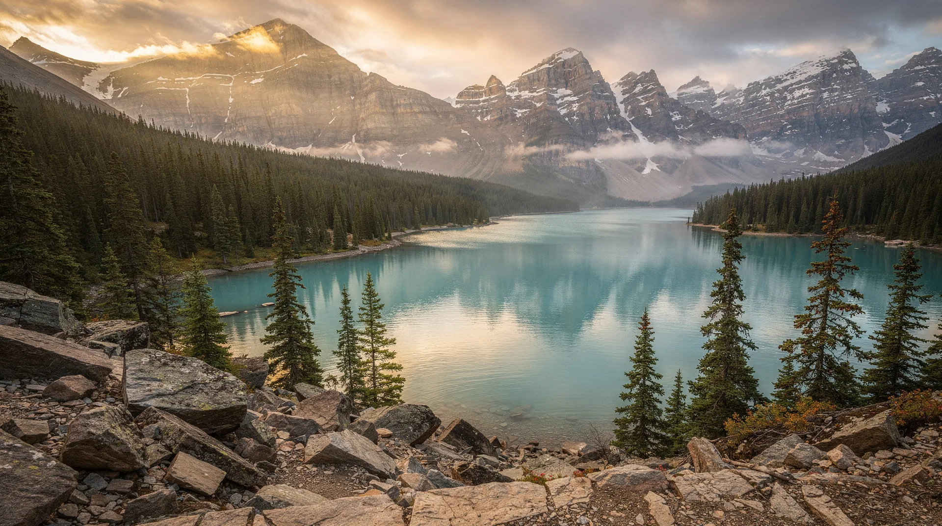
Kluane (pronounced kloo-AH-nee) is the central reason to come to Haines Junction. The park covers 22,015 square kilometres — a UNESCO World Heritage Site (jointly designated with the adjacent Wrangell-St. Elias National Park in Alaska) containing the largest non-polar icefield in the world, the largest concentration of Dall sheep in North America, and a wilderness area of such scale that most of it has never been visited by non-Indigenous people.
The Alaska Highway forms the park’s eastern boundary; from the road, you can see the front ranges of the St. Elias Mountains and, on clear days, the high summits of the icefield beyond. The icefield itself — the Kluane Icefield — is almost entirely hidden behind the first ranges. Understanding it requires either a flight or a multi-day wilderness traverse.
Dall sheep: Kluane is famous for its Dall sheep population — a race of white, thinly curved-horned sheep that inhabit the rocky ridgelines along the park’s front ranges. Sheep Mountain, visible from the Alaska Highway about 20 kilometres south of Haines Junction, is one of the most productive Dall sheep viewing areas in the Yukon. In summer and fall, hundreds of sheep graze the slopes visible from the highway shoulder. Binoculars reveal individual animals; a spotting scope shows the fine detail of fleece and horn.
Kluane wildlife: Beyond sheep, the park is home to grizzly bears, black bears, wolves, wolverines, caribou, moose, and golden eagles. The front ranges along the highway are productive for grizzlies in berry season (August–September). Lynx are present but rarely seen.
Day hikes from Haines Junction and the park boundary
The park has a limited but rewarding trail network accessible without wilderness permits:
Auriol Trail: A 15-kilometre loop south of Haines Junction through boreal forest and alpine terrain, with views of the St. Elias front ranges. The trail gains approximately 500 metres of elevation and takes 4–6 hours. Moose, grizzly bears, and Dall sheep are all possible encounters.
King’s Throne Trail: Accessed from Kathleen Lake, 27 kilometres south of Haines Junction on the Haines Road. The trail climbs steeply (1,050 metres of gain) to a cirque — “the throne” — above the lake, with views across Kathleen Lake to the Kluane front ranges. Strenuous but one of the most rewarding day hikes in the Yukon.
St. Elias Lake Trail: A short (10 km return) hike through forest to a mountain lake below the Dezadeash Range. Good for families and those who want a gentle introduction to the landscape.
Dezadeash River Loop: A flat, easy 4-kilometre trail along the Dezadeash River near Haines Junction. Bird watching is excellent — breeding warblers, sandpipers, and various waterfowl are regular.
Flightseeing Kluane
The icefield, the high peaks (including Kluane’s Mt. Logan at 5,959 metres — Canada’s and North America’s highest mountain), and the glacier systems are only accessible by air for the vast majority of visitors. Kluane flightseeing tours from Haines Junction take small planes or helicopters over the icefield, with glacier landings available through some operators. On a clear day, the view from altitude over an icefield that extends to every horizon — white, crevassed, and ancient — is one of the great aerial perspectives in Canada.
Cost: Flightseeing tours from Haines Junction run approximately CAD 300–500 per person for a 1-hour icefield flight. Glacier landing tours cost more. Book early in the season; good weather windows fill quickly.
Browse Yukon wilderness and Kluane National Park tours including flightseeing and hikingThe Alaska Highway experience
The Alaska Highway passes directly through Haines Junction — this is one of the iconic road corridors in North America. Built in 1942 in eight months as a military supply route during the Second World War, the highway connected Dawson Creek in British Columbia to Fairbanks, Alaska through previously roadless wilderness. The construction involved approximately 11,000 US Army soldiers and tens of thousands of civilian workers operating in sub-zero temperatures with minimal equipment.
The stretch between Whitehorse and Haines Junction is historically significant — you pass through the same terrain that road crews worked in 1942, with several original sections of the highway preserved nearby. The Champagne and Aishihik First Nations people of this region had their traditional territory dramatically affected by highway construction and the subsequent changes in access and settlement patterns.
Driving the Alaska Highway west from Haines Junction toward the Alaska border — through Destruction Bay and Burwash Landing — offers increasingly dramatic views of the St. Elias front ranges and the Kluane Lake basin.
Da Kų Cultural Centre
The Da Kų Cultural Centre in Haines Junction is the Champagne and Aishihik First Nations cultural facility, with exhibits on Southern Tutchone history, land use, and cultural practices. The centre is a genuinely worthwhile stop — the First Nation’s relationship with the landscape that became Kluane National Park is ancient and complex, and understanding that context enriches the experience of the park itself.
The centre hosts cultural events through the summer, including demonstrations of traditional skills and talks by First Nation members. Check the schedule on arrival in Haines Junction.
Where to eat and stay
Haines Junction has limited options, consistent with its size. The Raven Hotel is the main accommodation — clean, practical, and conveniently located near the Alaska Highway. The Cozy Corner Restaurant (connected to the Raven) serves reliable northern comfort food. The Village Bakery produces good baked goods from early morning and is the best breakfast option.
For longer stays, Kathleen Lake Campground in Kluane National Park (27 km south) provides well-maintained campsites in an alpine lake setting — the most atmospheric accommodation option for those with tents or RVs.
Getting there
From Whitehorse: 160 kilometres west on the Alaska Highway (Hwy 1), fully paved, approximately 1 hour 45 minutes. This is a beautiful drive that follows the Takhini River and then the Dezadeash watershed through increasingly open terrain.
From Alaska: The Haines Road (Hwy 3) connects Haines Junction to the Alaska Panhandle port of Haines — a 240-kilometre drive through some of the finest mountain scenery in North America, with the option of taking a ferry from Haines to Skagway and continuing to Whitehorse.
Book Yukon wilderness experiences and day tours from Whitehorse including Kluane accessRelated destinations
Haines Junction is the primary gateway to Kluane National Park. Whitehorse to the east is the Yukon’s capital and the logical base for a wider Yukon trip. The Yukon 7-day itinerary incorporates Haines Junction and Kluane as part of a circuit combining Whitehorse, the Dempster corridor, and Dawson City. Carcross to the south is another worthwhile Yukon stop on the circuit from Whitehorse.
Frequently asked questions about Haines Junction: Yukon’s Kluane Gateway
Is Kluane National Park accessible without hiking? Yes — the Alaska Highway along the park’s eastern boundary provides access to excellent wildlife viewing (Dall sheep on Sheep Mountain), pullouts with mountain views, and the visitor centre at the park boundary. Flightseeing is the most dramatic non-hiking way to experience the park’s interior.
Do I need to register for day hikes in Kluane? Day hiking on maintained trails does not require registration. Overnight backcountry travel requires Parks Canada registration and bear protection equipment. Backcountry camping in Kluane is for experienced wilderness travellers — the terrain is remote and rescue logistics are complicated.
How long should I spend in Haines Junction? A minimum of two full days gives you time for the King’s Throne hike or Auriol Trail, the Da Kų Cultural Centre, wildlife viewing on Sheep Mountain, and the Kluane visitor centre. Add a flightseeing tour and you need a third day.
Is the town worth visiting without going into Kluane? Honestly, no — the town itself is small and limited. The attraction is entirely the surrounding wilderness. If you are not interested in Kluane hiking, wildlife, or flightseeing, the time is better spent elsewhere in the Yukon.