The ultimate Canadian road trip experience
There are countries you visit, and there are countries you drive. Canada, emphatically, is the latter. Its landscape is most honestly experienced from a moving vehicle, watching the scenery unspool over distances that can’t be adequately conveyed in a photograph — the boreal forest extending to every horizon for two days straight, the Rockies materialising ahead of you as you drive west from Calgary, the cliffs of Cape Breton appearing around each new corner of the Cabot Trail.
I have done several significant Canadian road trips, and each one has confirmed the same thing: the drive itself is often the best part. Not the destination. The drive. Canada was designed, at some level, for exactly this — vast enough to require vehicles, varied enough to keep the windshield scenery changing across thousands of kilometres, with a highway infrastructure robust enough to support it.
Choosing your route: the fundamental decision
The Trans-Canada Highway runs for 7,821 km from St John’s, Newfoundland to Victoria, British Columbia. Driving it end to end is a genuine undertaking, requiring a minimum of two weeks at driving-hard pace, and three to four weeks if you actually want to stop and experience the places you’re passing through. Most people drive a section.
The most popular sections are:
The Rockies: Calgary to Vancouver via the Trans-Canada through Banff and Rogers Pass, or the more dramatic northern route through Jasper and then south down the Icefields Parkway to Banff before continuing west. The Icefields Parkway alone — 230 km between Banff and Jasper — is consistently rated among the most scenic drives in the world.
The Cabot Trail: A 300 km loop around the northern tip of Cape Breton Island in Nova Scotia. A day minimum, better as two days, ideally three.
The Icefields Parkway: Deserves its own mention even as a subset of the Rockies drive. Allow a full day, bring your camera, and prepare for a lot of unscheduled stops.
Ontario and Quebec: Toronto to Quebec City via Kingston, the Thousand Islands, and Montreal covers extraordinary diversity of landscape and culture in a manageable 900 km. Add a loop down through the Eastern Townships and back via the St Lawrence shore if you have time.
Newfoundland: A loop around the island — St John’s to the west coast via the Trans-Canada, north through Gros Morne, across the Northern Peninsula to L’Anse aux Meadows, and back — covers roughly 2,000 km and could absorb two weeks happily.
What driving in Canada is actually like
Canadian highways are well-maintained, well-signed, and predominantly straight. The Trans-Canada through the prairies achieves a flatness and straightness that becomes almost meditative — or monotonous, depending on your relationship with horizon-level scenery — for hundreds of kilometres. The Rockies bring mountain driving with occasional steep grades and sharp curves, but nothing technically demanding by Alpine standards.
Gas stations appear regularly on major routes but can be 100+ km apart in the north and in remote areas. Fill up whenever your tank is below half if you’re in unfamiliar territory. Gas prices vary significantly by province: British Columbia and the territories are the most expensive; Alberta, with no provincial sales tax, is usually the cheapest.
Wildlife on roads is a genuine hazard. Moose are the most dangerous — they’re large enough to come through a windshield and dark enough to be nearly invisible at night. Deer, elk, and bears also cross roads frequently. Drive slowly at dawn and dusk in forested areas, and treat wildlife warning signs as information rather than decoration.
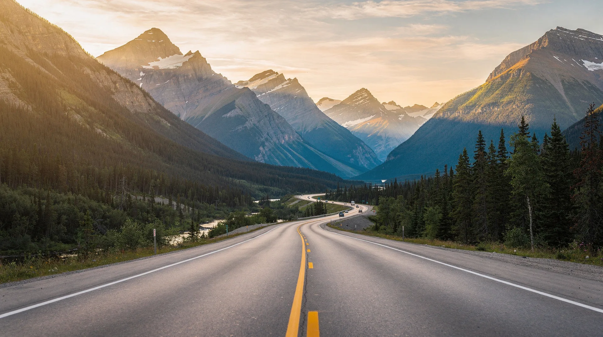
The Icefields Parkway in detail
No single drive in Canada is more consistently magnificent than the Icefields Parkway. The 230 km between Banff and Jasper passes: two active glaciers you can walk to, a dozen turquoise glacial lakes, waterfalls visible from the road, multiple hiking trailheads, two visitor centres, and wildlife sightings frequent enough that bear jams and elk jams (where traffic stops for an animal on or near the road) are a standard feature of the journey.
Budget a full day. Stop at the Columbia Icefield — the largest accumulation of ice south of the Arctic Circle — and consider the Athabasca Glacier walk if time permits. Pull over at every lake that catches your eye. The light changes the landscape from blue-grey morning through golden afternoon to the alpenglow that turns the peaks pink at dusk, and each hour reveals something different.
Guided multi-day tours of Banff and Jasper national parks include the Icefields Parkway with an expert guide who can explain the geological and ecological significance of what you’re seeing — worth considering if this is your first visit to the Rockies.
The Cabot Trail: one day or three?
The Cabot Trail loops 300 km around the northern tip of Cape Breton Island, through Cape Breton Highlands National Park, along cliffs above the Atlantic, and through small Acadian and Scottish Gaelic communities that have maintained distinct cultural traditions for three centuries.
One day is the minimum: enough to drive the loop with strategic stops — the Skyline Trail trailhead for a walk out to ocean views, the French mountain lookout, the village of Chéticamp on the western side, the Cabot Trail descent into Ingonish on the east. Two days is better, with a night in the park or in one of the small towns on the loop. Three days allows real hiking, morning light on the western cliffs, and evenings in Cape Breton pubs.
The direction you drive matters: counterclockwise (starting from Baddeck, heading north to Chéticamp, then east through the park) puts you on the ocean-cliff side of the road for the most dramatic sections. Clockwise still gives you the same views but from the mountain rather than the cliff edge.
Packing for a Canadian road trip
Beyond standard travel packing, Canadian road trips have specific requirements:
Bug protection: Black flies and mosquitoes are present throughout most of Canada from late May through early August. DEET-based repellent or a permethrin-treated outer layer is essential for any time spent outdoors in forested areas. This is not a mild inconvenience — unprotected exposure to black flies in peak season is genuinely miserable.
Layers: Weather in Canada changes quickly and varies dramatically by altitude and geography. Even in July, evenings in the Rockies can be cold enough for a down jacket. Rain is possible any time of year in most regions. Dressing in layers — base, mid, outer shell — remains the most effective system.
Emergency kit: A standard roadside emergency kit (jumper cables, flares, basic tools, emergency blanket) is prudent for any remote driving in Canada. Cell coverage disappears in many areas. A physical road atlas or downloaded offline maps are worth having.
Bear spray: If you plan to hike at all in the Rockies, BC, or anywhere bears are active, carry bear spray and know how to use it. Many rental car shops at Rockies gateways offer it as an add-on.
Road trip costs: what to budget
Fuel: at approximately CAD $1.50–2.00/litre (prices vary by province and fluctuate with crude prices), a 3,000 km road trip in a standard car consuming 10L/100km costs roughly CAD $450–600 in fuel.
Car rental: CAD $50–120/day for a standard vehicle. An SUV costs more but handles Rockies weather and backcountry roads better. Book well in advance in peak season — rental car supply in Banff and other major tourist hubs is genuinely limited.
Accommodation: as covered in the budget breakdown article, this varies enormously. Budget for camping in national parks (CAD $20–40/night) up to Fairmont hotels (CAD $400+/night).
Final thoughts
The road trip is Canada’s native travel format. The country was connected by road long before most of its population centres were connected by air, and the highways tell the story of how Canada was built — through geography that resisted habitation, across distances that required real commitment to cross.
Drive it slowly. Stop more than your itinerary allows for. Leave days unscheduled. Canada is most rewarding when you’re willing to follow the light around a corner, pull over for a moose in a pond, or spend three hours at a waterfall you hadn’t planned to visit at all.
The itineraries section has detailed road trip routes for all the major regions, including suggested daily stages, best stopping points, and accommodation recommendations.
Frequently asked questions about The ultimate Canadian road trip experience
Do I need an international driving permit for Canada?
Most countries’ driving licences are accepted in Canada. An International Driving Permit (IDP) is a useful supplement for countries whose licences aren’t in English or French, but is not generally required for Western European, Australian, or US drivers. Check with the rental car company when booking.
What’s the best time of year for a Canadian road trip?
Summer (June–August) offers the best weather and longest days but also peak crowds and highest prices. September and early October are excellent for the Rockies (larch season) and eastern Canada (foliage). Spring (May) offers waterfalls and wildflowers but can bring unpredictable weather. Winter driving is possible but requires experience, appropriate tyres, and careful planning.
Can I drive from the US into Canada?
Yes, at any of the Canada–US land border crossings. You’ll need a valid passport (or NEXUS card for pre-approved travellers). Wait times at popular crossings (Peace Arch in BC, Rainbow Bridge/Queenston-Lewiston at Niagara) can be long on summer weekends. Less busy crossings save significant time.
Are there toll roads in Canada?
Very few compared to Europe or the US. Ontario has some toll highways (407 ETR around Toronto). Most Canadian highways, including the Trans-Canada, are toll-free. Some bridges charge tolls but amounts are generally modest.