Cabot Trail: Nova Scotia's ultimate scenic drive
How long does the Cabot Trail take to drive?
The full 298-km loop takes about 4.5 hours without stops. Most visitors take 2–3 days to do it properly, spending nights in Cheticamp, Ingonish, or Baddeck. October is peak season for autumn foliage; summer for hiking, whale watching and the full range of activities.
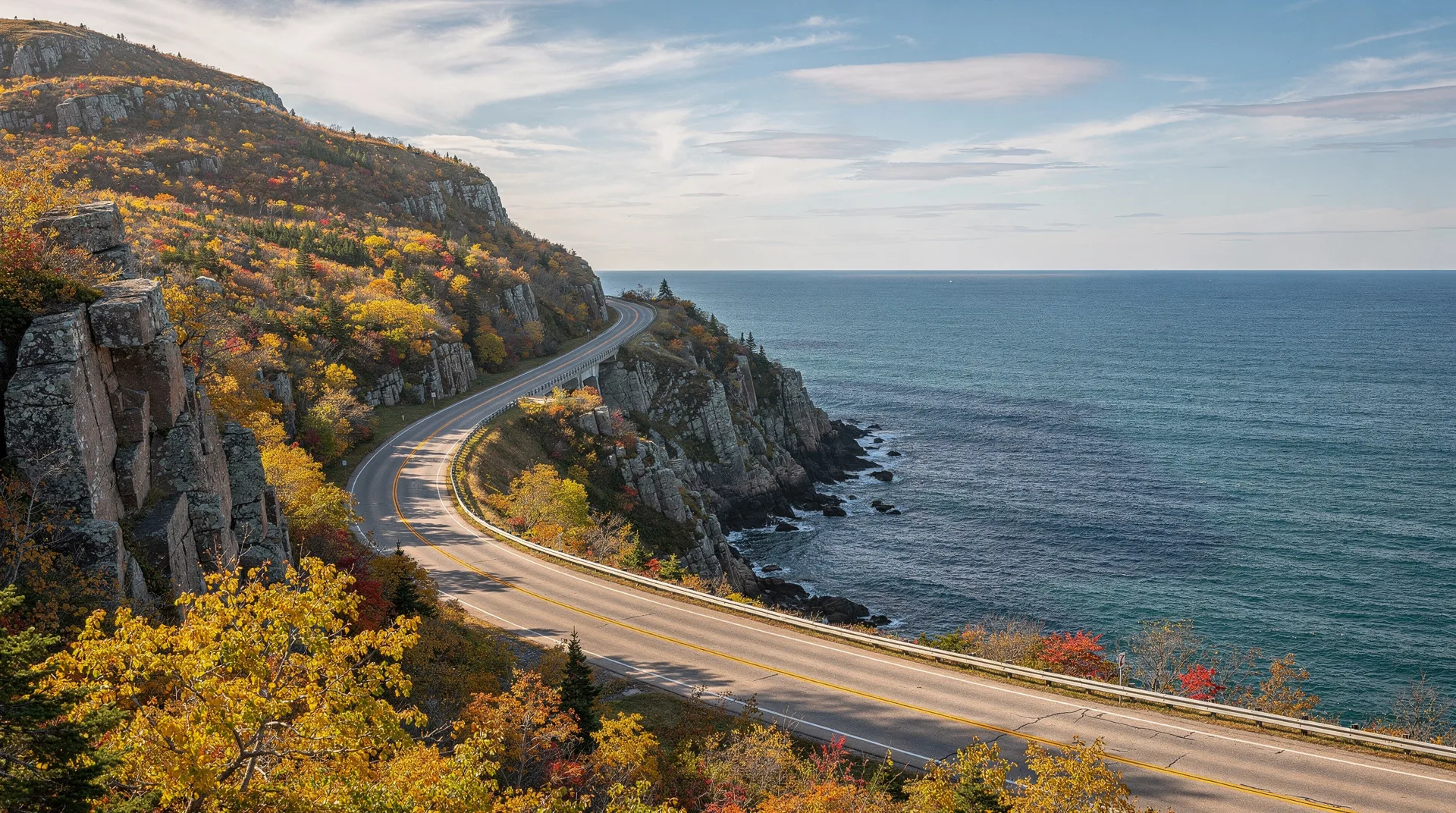
Cape Breton Island sits at the northeastern tip of Nova Scotia like an afterthought — remote, rugged, and dramatically beautiful in ways that have been drawing visitors since long before any highway existed. The Cabot Trail, a 298-km loop road that circles the northern part of the island through Cape Breton Highlands National Park, is consistently ranked among the most scenic drives in North America, and it earns the designation every single time.
Named for the explorer John Cabot, who may or may not have landed on Cape Breton in 1497 (the historical debate continues), the trail connects Acadian fishing villages, Mi’kmaq communities, highland barrens above the Gulf of St. Lawrence, and some of the finest coastal scenery in eastern Canada. The drive also serves as a framework for the island’s outdoor activities — whale watching from Cheticamp and Pleasant Bay, the Skyline Trail hike in the national park, the sea kayaking around northern Cape Breton, and the autumn foliage that blankets the highlands in October.
The route: clockwise or counterclockwise?
Most visitors drive the Cabot Trail clockwise — starting from the Trans-Canada Highway junction at Canso Causeway, heading up through Baddeck and Margaree Harbour on the western side, then continuing north through Cheticamp into the national park, crossing the highlands, descending to Ingonish on the eastern coast, and returning south to Baddeck.
Clockwise has practical advantages: the road is on the inside of the cliff-edge sections when you’re driving north up the western coast, making the views more open and the driving slightly less vertiginous. The afternoon light tends to be better on the eastern descent when driving this direction.
Counterclockwise works equally well and has advocates. Either way, plan to stop frequently — particularly between Cheticamp and Cape North, where viewpoints over the Gulf of St. Lawrence appear relentlessly.
The full loop from Baddeck is 298 km. For reference, Baddeck is approximately 420 km from Halifax by highway (about 4 hours), or 470 km via the scenic Sunrise Trail route along the Northumberland Shore.
Baddeck: the classic Cabot Trail base
Most Cabot Trail itineraries begin and end in Baddeck, a small town on Bras d’Or Lake that serves as the island’s heritage tourism centre. Alexander Graham Bell, inventor of the telephone, spent the last 35 years of his life at his estate Beinn Bhreagh near Baddeck, and the Alexander Graham Bell National Historic Site downtown houses an exceptional collection of his inventions and experiments — including his work on hydrofoil boats, tested on the lake.
Baddeck’s waterfront is charming, with several good restaurants and the opportunity to walk directly to the Bell museum from the town centre. Bras d’Or Lake itself — technically a tidal estuary rather than a freshwater lake, connected to the Atlantic by two narrow channels — is a UNESCO Biosphere Reserve and offers sailing, kayaking, and bald eagle watching.
Cheticamp: the Acadian gateway
Cheticamp, on the western coast, is the main Acadian community on Cape Breton and the western gateway to Cape Breton Highlands National Park. The waterfront village has maintained its Acadian French culture and language more completely than almost anywhere in Nova Scotia outside Yarmouth. The church of Saint-Pierre dominates the waterfront; the hooked-rug tradition for which Cheticamp is famous produces some of the finest examples of the craft in Canada, displayed at the co-operative gallery on the main street.
Whale watching tours operate from the Cheticamp wharf, with pilot, minke, and humpback whales commonly seen in the gulf. The season runs June to October. Boat tours also visit the dramatic sea stacks off the national park coastline.
The national park entrance is 3 km north of town. The 15-km Cabot Trail section through the park’s western sector climbs from sea level to over 400 metres in a series of switchbacks before traversing open highland barrens with continuous views over the gulf.
Browse guided tours and experiences on Cape Breton IslandCape Breton Highlands National Park
The national park occupies 950 square kilometres of the northern Cape Breton plateau — a high, rolling tableland of boreal forest, bogs, and exposed barrens cut by deep river canyons where the plateau falls away to the coast. The landscape resembles Scottish highland rather than typical Maritime scenery, which explains why Scottish settlers felt immediately at home here when they arrived in the 18th and 19th centuries.
The park contains 26 hiking trails totalling about 270 km. Most are accessible directly from the Cabot Trail highway, making it easy to combine driving with hiking without special planning.
Skyline Trail (9.3 km loop)
The Skyline Trail is the jewel of Cape Breton Highlands and one of the finest coastal hikes in Canada. The trail climbs through mixed forest to an open coastal headland where the plateau drops in cliffs to the Gulf of St. Lawrence. The final kilometre traverses exposed barrens, ending at a boardwalk platform 430 metres above the water. Moose are almost always present on the barrens. Pilot whales are frequently visible in the gulf below.
The sunset from the Skyline boardwalk is famous; Parks Canada operates ranger-led sunset tours in summer. Arrive early — the trail parking fills by mid-morning on summer days.
See our best hikes in Canada guide for more detail.
Franey Trail (7.4 km loop)
The Franey climbs to the highest readily accessible viewpoint in the park, at 535 metres above sea level, with a 360-degree panorama over Ingonish Bay, the Atlantic ocean, and the highlands interior. The ascent is steep and can be demanding in summer heat; the views from the summit fire tower justify every metre of elevation gain.
Lone Shieling (one-way, 1 km)
A flat, ancient-forest walk to a replica Scottish shieling (shepherd’s hut) in a grove of 350-year-old sugar maples. The grove is one of the finest examples of old-growth northern hardwood forest in Atlantic Canada, and the maples’ October colour display is exceptional.
Middle Head Trail (4.4 km return)
A peninsula walk from the Keltic Lodge resort at Ingonish, through spruce forest and across open headland to the tip of a finger of land jutting into the Atlantic. Seals are frequently visible in the waters below the clifftop trail.
Cape North and the northern tip
Beyond the national park’s eastern boundary, the highway loops around the northern tip of Cape Breton via the small community of Cape North. Side roads lead to Meat Cove — a dramatic fishing settlement at the end of a 14-km gravel road on the island’s northernmost point — and to Bay St. Lawrence, a small harbour known for whale watching.
Pleasant Bay, on the western coast just south of Cape North, has become one of the better whale watching bases on the island. The area sees large numbers of pilot whales (which are actually the largest member of the dolphin family) regularly in summer, along with minkes, humpbacks, and occasionally fin whales. Several small operators run tours from the harbour; these tend to be smaller and more intimate than the Cheticamp operations.
Ingonish and the eastern coast
Ingonish is the eastern gateway to the national park and the base for the Highlands Links golf course — consistently ranked among the top public courses in Canada, designed by Stanley Thompson in 1941 in a spectacular coastal setting. The Keltic Lodge resort at Ingonish Beach is the area’s premier accommodation, a dramatic Arts and Crafts building on the Middle Head peninsula.
The eastern Cabot Trail from Ingonish to Baddeck runs through the Margaree Valley — salmon fishing country, with the Margaree River offering some of the best Atlantic salmon angling in eastern Canada — before returning to the Trans-Canada.
Browse guided tours across Nova ScotiaBest time to drive the Cabot Trail
June: Park trails open; whale watching season beginning. Longer daylight hours. Wild irises blooming along the highway. Fewer crowds than summer peak.
July–August: Summer peak. All services operating. Hiking, kayaking, whale watching all at their best. Accommodation very limited; book months ahead. Excellent weather on average, though fog is possible on the coast.
September: Excellent month. Crowds thinning. Whale watching still active. Hiking conditions good. First hints of autumn colour by month’s end.
October: The most spectacular month visually. Cape Breton’s hardwood forests produce some of the finest autumn foliage in Canada, particularly in the Margaree Valley and around the plateau’s edges. Peak colour typically arrives in the second and third weeks of October. Very busy during colour peak; book accommodation in advance.
November–April: The park’s interior campgrounds close; some services shut. The drive is still possible and largely beautiful. Winter offers solitude and occasional dramatic snowscapes but some services are closed and weather can be severe.
How to get to Cape Breton
From Halifax: Drive north on Highway 104 via the Trans-Canada. Total distance to the Canso Causeway (Cape Breton entrance) is about 260 km, approximately 2.5 hours. Add another hour to reach Baddeck.
By air: Sydney (Cape Breton) has an airport with direct connections to Halifax, Toronto, and seasonal routes. Flying to Sydney and picking up a rental car there is the most time-efficient option for those coming from afar.
By bus: Maritime Bus connects Halifax to Sydney with stops including Baddeck. Frequency is limited and you will need a rental car to properly explore the Cabot Trail.
Costs (in CAD)
| Item | Approximate cost |
|---|---|
| Cape Breton Highlands NP day pass | $8.50 adult (or Discovery Pass) |
| Whale watching tour (Cheticamp/Pleasant Bay) | $45–$65 per person |
| Skyline sunset guided hike | Free (park ranger-led) |
| Mid-range B&B per night | $120–$200 |
| Keltic Lodge per night | $250–$500 |
| Highlands Links golf | $75–$115 green fees |
| Seafood dinner (lobster, etc.) | $35–$65 per person |
Where to stay
Baddeck: Inverary Resort (comfortable, lakefront, full facilities), Telegraph House (historic, central), various B&Bs. Base camp for beginning and ending the loop.
Cheticamp: Laurie’s Motor Inn (reliable mid-range), Cheticamp Outfitters Inn. Limited options; book ahead.
Cape Breton Highlands NP: Chéticamp and Ingonish campgrounds operated by Parks Canada. Reserve through reservation.pc.gc.ca.
Ingonish: Keltic Lodge (the iconic choice, exceptional setting), several B&Bs and cottages in the area. Very limited; summer and October dates require months of advance booking.
Pleasant Bay: Cabot Trail Sea & Golf Chalets, small guesthouses. Intimate and quiet.
Food and drink on the trail
Cape Breton’s seafood deserves its reputation. Lobster is the headline act, available boiled live from August through October in particular. Dungeness crab, snow crab, clams, and fresh Atlantic salmon are all local. The Acadian communities add rappie pie (a traditional potato and meat dish) to the menu.
The Rusty Anchor Restaurant in Pleasant Bay is perennially recommended for seafood. The Red Shoe Pub in Mabou (southern Cape Breton, slightly off the main Cabot Trail route) is a beloved institution for live Celtic music and local food. Farmer’s Daughter Country Market, near Baddeck, stocks excellent local provisions.
Browse guided tours and experiences from HalifaxFrequently asked questions about Cabot Trail: Nova Scotia’s ultimate scenic drive
How many days should I spend on the Cabot Trail?
Minimum two nights; three nights is better and allows time for hiking, whale watching, and leisurely exploration. With two nights, stay one night each in Cheticamp and Ingonish (or Baddeck). With three nights, add a night in Baddeck for the Bell museum and lake activities.
Can I drive the Cabot Trail in one day?
Yes, the full loop is driveable in one day (about 4.5 hours driving), but you will miss nearly everything worthwhile. A single overnight stop at minimum is strongly recommended.
Is the Cabot Trail suitable for RVs?
Yes, with caveats. The highland sections involve steep switchback roads; RVs over 8 metres should be driven slowly and carefully. All major campgrounds accommodate RVs. The road is paved throughout but narrow in places.
Are there cell phone towers on the Cabot Trail?
Coverage is reasonable in Cheticamp and Ingonish but spotty in the highland interior and along the northern tip. Download offline maps before setting out. Emergency phones are located at park campgrounds.
When do the whales appear?
Pilot whales are typically present from June through October in the waters off Pleasant Bay and Cheticamp. Minkes and humpbacks are common from July through September. Fin whales are occasionally seen. Specific species sightings depend on prey availability and vary year to year.
Is the Cabot Trail worth visiting without a car?
Very difficult without a car. Cheticamp and Ingonish can be reached by shuttle from Sydney in summer, but the freedom to stop spontaneously at viewpoints and trailheads is integral to the experience. Renting a car in Sydney or Halifax is strongly recommended.
What is the road like in terms of difficulty?
The Cabot Trail is a well-maintained paved highway throughout. The highland sections involve significant gradient and switchbacks that can be demanding for nervous drivers or those unfamiliar with mountain roads. There are no genuinely dangerous sections, but slow down on descents and watch for moose, particularly at dawn and dusk.