Viking Trail, Newfoundland: L'Anse aux Meadows & beyond
What is the Viking Trail in Newfoundland?
The Viking Trail is Route 430, a 500-km highway running up the Northern Peninsula from Deer Lake to St. Anthony. It passes through Gros Morne National Park (UNESCO World Heritage Site) and continues to L'Anse aux Meadows — the only confirmed Norse settlement in North America, established around 1000 CE.
The Norse arrived on the North American continent five centuries before Christopher Columbus, and the proof is here, on a remote headland at the northern tip of Newfoundland: the remains of eight turf-walled buildings excavated from the soil, carbon-dated to approximately 1000 CE, matching Norse building traditions documented in Iceland and Greenland. L’Anse aux Meadows is the only confirmed pre-Columbian European settlement in the Americas, a UNESCO World Heritage Site since 1978, and one of the most historically significant places on the continent.
Getting there is the Viking Trail — Route 430, running 500 kilometres up the Northern Peninsula of Newfoundland from Deer Lake, past Gros Morne National Park (itself a UNESCO World Heritage Site), through an increasingly remote landscape of bogs, fjords, and ancient geology to the northern tip where the settlement awaits. The journey is as memorable as the destination.
The Viking Trail: overview of the route
The Viking Trail begins, conventionally, at Deer Lake on the Trans-Canada Highway — the practical entry point for anyone flying into western Newfoundland (Deer Lake Regional Airport has connections to Halifax and Toronto). From Deer Lake to St. Anthony (the nearest town to L’Anse aux Meadows) is approximately 445 km; to L’Anse aux Meadows itself is about 500 km.
The drive can be done in a single long day, but this misses almost everything worth stopping for. A minimum of 3-4 nights along the route is recommended; a week or more allows a genuinely full exploration.
Route 430 is paved throughout and in generally good condition, though the northern sections beyond St. Barbe can be rough in spring before road maintenance catches up with winter damage. Cellular coverage is limited north of Cow Head; download offline maps before departing Deer Lake.
Gros Morne National Park: the first great stop
Gros Morne National Park is, arguably, the geological wonder of eastern Canada. The park protects 1,800 km² of landscape shaped by two extraordinary processes: ancient continental collision that pushed ocean floor rock (the Tablelands) onto the continental crust, and glacial sculpting that carved the fiord-like Western Brook Pond into the plateau.
The Tablelands
The most visually distinctive feature of Gros Morne is the Tablelands — a burnt-orange plateau of peridotite rock that looks, unmistakably, alien. This is ocean floor mantle rock, pushed up by tectonic forces during the closure of the Iapetus Ocean 450 million years ago. The rock is toxic to most plants (it lacks silica and contains high concentrations of heavy metals), producing the barren moonscape appearance that makes the Tablelands instantly recognisable.
The Tablelands Trail (4 km return) begins at a parking area on Highway 431 (the Trout River road) and walks into the heart of the orange plateau. This is geology you can touch — a piece of the earth’s mantle normally buried kilometres underground, accessible by a moderate walk.
Western Brook Pond
Western Brook Pond is not a pond — it is a landlocked fiord, a river-carved canyon now isolated from the sea by coastal uplift since the last ice age. The canyon walls rise 600 metres above the still, aquamarine water; the scale is overwhelming.
Access requires a 3-km walk across a flat coastal bog from the highway, followed by a 2-hour boat tour of the fiord. The boat tour is the best way to appreciate the scale — sitting in a flat-bottomed tour boat with cliff walls rising 600 metres on either side, waterfalls cascading from the plateau into the water, is one of the most impressive inland experiences in eastern Canada.
Reserve the boat tour ahead: The Western Brook Pond boat tours are popular and capacity is limited. Book online through Parks Canada.
The town of Rocky Harbour
Rocky Harbour is the main service centre for the park and the best base for a multi-day park visit. The Gros Morne Discovery Centre (the visitor centre for the park, with excellent geological exhibits) and several good restaurants and accommodation options are located here.
Browse Newfoundland tours and Gros Morne experiencesThe northern peninsula: beyond Gros Morne
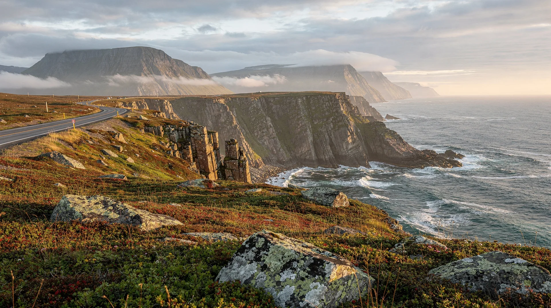
North of the park boundary at St. Paul’s, the Viking Trail enters a more sparsely populated section of the peninsula. Communities become smaller and more widely spaced; the landscape opens into bog, scrub forest, and coastal barrens with increasing frequency. This is one of the most remote driving experiences in Atlantic Canada, and its emptiness is part of its power.
Cow Head
The small community of Cow Head (named for a resemblance in the shape of its headland, not livestock) contains the Cow Head Theatre — home to the Gros Morne Theatre Festival, which each summer stages professional theatre productions in a community centre venue. The combination of high-quality theatre and remarkable surrounding landscape has made this an unlikely cultural destination.
Port au Choix
Port au Choix National Historic Site preserves evidence of 5,500 years of Indigenous occupation — Maritime Archaic, Dorset Palaeo-Inuit, and Groswater peoples, each of whom lived here for centuries. The site museum contains excavated artifacts from multiple cultures, including the remarkable Maritime Archaic cemetery at Philip’s Garden where burial practices and material culture from 4,000 years ago have been remarkably preserved.
Port au Choix is also a prime area for iceberg viewing in May-June, with bergs frequently visible from shore. See our iceberg viewing guide for the best timing.
St. Barbe and the Labrador ferry
From St. Barbe, a ferry crosses the Strait of Belle Isle to Blanc-Sablon, Quebec — the southern gateway to the Labrador coast. The Labrador coast route (the Trans-Labrador Highway and its coastal communities) is beyond the scope of the Viking Trail but represents an extraordinary further extension of the journey for those with time and appetite for remote travel.
L’Anse aux Meadows National Historic Site
The destination. The Norse settlement at L’Anse aux Meadows was discovered in 1960 by Norwegian explorer Helge Ingstad and archaeologist Anne Stine Ingstad, who identified the turf mounds visible near the northern headland as Norse constructions. Excavation confirmed their identification; the site has been a UNESCO World Heritage Site since 1978.
What you see
The site today presents excavated foundations — the original Norse buildings are covered for preservation — and reconstructed Norse longhouses built directly from the archaeological evidence. The reconstructed buildings are the most effective way to understand what the settlement looked like: large, dim, smoky timber-framed longhouses covered in turf sod, with central hearths and multi-functional interior spaces.
Inside the reconstructions, Parks Canada staff in period dress demonstrate Norse crafts and activities — blacksmithing, weaving, boat maintenance. The interpretive program is unusually good: the guides are knowledgeable about both the archaeological evidence and the sagas, and can speak to both with authority.
What the evidence tells us
The site shows evidence of habitation by approximately 70-90 people. Artifacts include iron rivets (nails used in boat construction), a spindle whorl (used in spinning yarn — and therefore proving that women were present, contradicting the all-male exploration narrative), butternuts (native to the Gulf of St. Lawrence area, suggesting the Norse reached areas farther south), and slag from iron smelting (the only iron smelting in pre-contact North America).
The settlement appears to have operated for approximately 10 years before being abandoned. The Vinland sagas — Old Norse accounts of exploration, particularly the Saga of the Greenlanders and Eirik the Red’s Saga — describe settlement in a land called Vinland; L’Anse aux Meadows is broadly accepted as at least one of the Vinland sites described.
Norstead
Approximately 2 km from the historic site, Norstead is a privately operated Viking village reconstruction that offers a more active and participatory complement to the Parks Canada site. Visitors can try archery, help steer a replica Norse vessel, and examine artifacts in a more hands-on setting. It is a worthwhile addition to the L’Anse aux Meadows visit, particularly for families.
St. Anthony: the gateway town
St. Anthony (population approximately 2,400) is the largest community in the northern Peninsula and the practical base for visiting L’Anse aux Meadows (28 km from town via Route 436). The town has accommodation, restaurants, a fuel station, and is an excellent whale watching and iceberg viewing base — its position on the Labrador Current makes both reliably productive in season.
Fishing Point Park on the headland outside St. Anthony offers clifftop viewing of icebergs and whales without any tour fee, sometimes producing extraordinary combinations of both in the same frame in May-June. See our iceberg viewing guide for timing details.
Planning your Viking Trail trip
Getting there
Fly to Deer Lake: Deer Lake Regional Airport (YDF) has connections to Halifax, Toronto, and Montreal. This is the most practical starting point for a dedicated Viking Trail itinerary. Pickup a rental car at the airport.
Drive from St. John’s: It is possible to drive from St. John’s to L’Anse aux Meadows, but the total distance (approximately 1,000 km) makes this a multi-day drive in each direction. Our 7-day Viking Trail itinerary is built around a fly-in to Deer Lake approach.
Ferry from Nova Scotia: The Marine Atlantic ferry from North Sydney, Nova Scotia to Port aux Basques (western Newfoundland) arrives near Deer Lake. See our Marine Atlantic ferry guide for details.
When to go
June: The best month for combining Viking Trail with iceberg viewing and the first reliable whale watching. L’Anse aux Meadows is open and the weather is improving.
July-August: Peak season; all services are operating, whale watching is at its best, and the long Newfoundland summer days allow extended exploring.
September: Excellent timing — quieter, autumn colours beginning, whale watching still good. Some accommodation and attractions may reduce hours.
Accommodation along the route
Rocky Harbour (Gros Morne) has the widest range of options. Cow Head and Port au Choix have small inns and B&Bs. St. Anthony has several hotels including the Vinland Hotel and Nordic Lodge. Book ahead for June-August.
Frequently asked questions about Viking Trail, Newfoundland: L’Anse aux Meadows & beyond
How long is the drive from Deer Lake to L’Anse aux Meadows?
Approximately 445 km to St. Anthony, plus 28 km to L’Anse aux Meadows from St. Anthony — about 5 hours’ driving without stops. Gros Morne, Port au Choix, and other stops make the route a 3-4 day minimum journey.
Is L’Anse aux Meadows open year-round?
The national historic site is open from early June through mid-October. Check Parks Canada’s website for current seasonal hours.
Was L’Anse aux Meadows really a Viking settlement?
Yes — the archaeological evidence is definitive and internationally accepted. The buildings, artifacts (particularly the iron-working evidence and the butternuts), and carbon dating all confirm a Norse presence around 1000 CE. What remains debated is how L’Anse aux Meadows relates to the specific locations described in the Vinland sagas.
Do I need a 4WD vehicle?
No. Route 430 is paved and maintained. The gravel road to Meat Cove (beyond Cape North on the tip) requires higher clearance but is not part of the Viking Trail proper.