Plain of Six Glaciers hike & tea house: all you need to know
How long is the Plain of Six Glaciers hike?
The Plain of Six Glaciers hike is 13.8 km return from the Fairmont Chateau Lake Louise, with 385 m elevation gain. Most hikers take 4–5 hours. The historic tea house at the end of the maintained trail serves food from mid-June to early October.
The Plain of Six Glaciers is consistently ranked among the finest day hikes in the Canadian Rockies — and among the finest in Canada. The combination of iconic scenery from the moment you step onto the trail, a clearly defined destination with a historic teahouse reward, and the sheer scale of the glaciated amphitheatre at trail’s end makes this a hike that consistently exceeds expectations, even for people who have heard the hype.
Starting from the Fairmont Chateau Lake Louise — itself one of the most photographed buildings in the country — the trail follows the turquoise lakeshore before climbing steadily through subalpine forest, past an active moraine, and onto the rocky plain below Victoria, Lefroy, Upper Victoria, Lower Victoria, Aberdeen, and Crowfoot glaciers. The teahouse at 2,135 metres has operated since 1924, and everything served there arrives by horse because there is no road.
Trail overview
Trailhead: Fairmont Chateau Lake Louise (lakeshore path, west end) Distance: 13.8 km return Elevation gain: 385 m Difficulty: Moderate Duration: 4–5 hours return Trail surface: Well-maintained path transitioning to a rocky moraine in the upper section Dogs: Permitted on leash
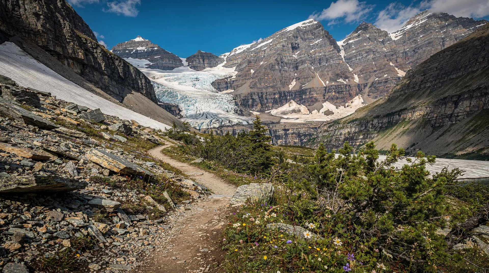
The trail begins at the lakeshore and follows the north shore of Lake Louise for approximately 2 km — the colour of the lake shifts from turquoise near the hotel to a deep glacial green as you progress. You are walking toward the headwall; the gap between Mount Niblock and Mount St. Piran gradually reveals the glaciated terrain ahead.
At approximately 3.5 km, the trail begins its gradual elevation gain through the subalpine forest. The tree cover opens progressively as you gain height. By 5 km you are above the tree line and walking across moraine debris left by the retreating Victoria Glacier. The scale here becomes apparent: the limestone walls on both sides tower hundreds of metres above, and the glaciers that were once at your elevation are now visible as retreating ice fields hundreds of metres up the rock faces.
The maintained trail ends at the teahouse at approximately 6.9 km. Beyond the teahouse, a rough scramble path continues another 400 metres to the moraine crest for a closer view of the glaciers — marked but not officially maintained.
The Plain of Six Glaciers Tea House
The teahouse was established in 1924 by the Canadian Pacific Railway as an overnight hut for guests of the Chateau. It has operated continuously since then — closing only in 2020 due to COVID restrictions and reopening the following year — making it one of the oldest continuously operating high-elevation food facilities in Canada.
Operating season: Mid-June through the first weekend of October, daily from approximately 9 am to 5 pm. Hours depend on weather and horse supply schedules; check their social channels before a long drive if the timing matters.
Menu: Simple, hearty mountain food: homemade soups, sandwiches, baked goods (the scones are famous), and a selection of teas and hot chocolate. Everything is brought up by horse, which limits but also determines the menu’s character — nothing fancy, everything satisfying after a 7 km approach.
Seating: Indoor and outdoor deck seating. The deck looks directly toward the Victoria Glacier and is the obvious choice on calm, sunny days. On cold or windy days the inside (wood-stove heated) is more comfortable.
Pricing: Expect slightly elevated prices reflecting the logistics of a horse-supply-only kitchen. Cash and card accepted.
The six glaciers
The trail’s name refers to six named glaciers visible from the plain. From left to right as you face the headwall:
- Victoria Glacier — the largest and most accessible, draped over the col between Mount Lefroy and Mount Victoria
- Upper Victoria Glacier — the upper section above the col
- Lower Victoria Glacier — descending toward the plain on the left side
- Lefroy Glacier — clinging to the south face of Mount Lefroy
- Aberdeen Glacier — on the north face of Mount Aberdeen (rightmost of the visible walls)
- Crowfoot Glacier — visible only from the upper viewpoint above the teahouse
The glaciers are notably smaller than they were when the teahouse opened in 1924. Photographs from that era show ice that reached nearly to the current trail level; today’s glaciers are hundreds of metres higher and retreating visibly decade by decade. The Plain of Six Glaciers is, among other things, one of the most striking visual records of climate change in the Canadian Rockies.
Practical information
Getting to the trailhead
The trailhead is accessed from the Fairmont Chateau Lake Louise, 56 km west of Banff townsite. Lake Louise Drive (4 km off the Trans-Canada Highway) leads to the parking area adjacent to the hotel. The lot fills by 9 am on most summer days.
Parks Canada operates a mandatory shuttle service from Lake Louise Village during peak season (typically late June through September). Private vehicle access to the parking area may be restricted — verify the current year’s rules on the Parks Canada website before planning your visit. Alternatively, stay in Lake Louise Village and walk 3 km to the trailhead on the Lake Louise Lakeshore trail.
Parks Canada entry
Banff National Park requires a valid Parks Canada Discovery Pass. Purchase at the gate, online, or via the Parks Canada mobile app.
Best time to hike
July and August: Peak season. The teahouse is reliably open, weather is warmest, and the upper trail is snow-free. Start by 7 am to beat crowds at the lake and enjoy a quiet approach.
September: Widely considered the optimal month. Smaller crowds, sharp light, cooler temperatures, and autumn colours in the valley. The teahouse remains open through early October.
Late June: The lake is beautiful and the trail is accessible, but snow patches may persist on the upper moraine section. Trekking poles help with balance.
Off-season: The teahouse is closed from October through mid-June. The trail to the teahouse is accessible via snowshoe in winter, but the approach across the moraine becomes genuinely technical in avalanche conditions — winter travel in this area requires experience and awareness of slide paths from the surrounding peaks.
What to bring
- Hiking boots (waterproof and ankle-supporting — the moraine section is rocky and uneven)
- Rain jacket (afternoon thunderstorms are regular in summer)
- Warm layer for the teahouse deck (wind off the glaciers is cold even in August)
- Sunscreen and sunglasses (intense UV on the open moraine)
- 2 litres of water per person minimum (the approach is longer than it feels on a map; exertion is steady)
- Bear spray (active bear country throughout the trail)
- Trekking poles (strongly recommended for the descent across moraine)
- Cash or card for the teahouse
Extending the hike
Upper viewpoint above the tea house
From the teahouse, a rough but marked path climbs a further 200 m elevation to a moraine crest above. This adds approximately 1 hour to the round trip and brings you significantly closer to the lower glaciers. The scramble is loose in places; poles and careful footwork needed. The view from the crest — looking directly at the Victoria Glacier with the tea house and Lake Louise below — is exceptional.
Lake Agnes connection (full traverse)
A traverse trail connects the Plain of Six Glaciers with Lake Agnes, crossing the headwall between the two cirques at approximately 2,300 m. This demanding loop (approximately 14 km total, 550 m elevation gain) allows you to visit both teahouses in the same day — a classic “two teahouses” day that is very popular with experienced Banff hikers. See our Lake Agnes Tea House hike guide for details on the Lake Agnes side.
Safety and trail etiquette
Rockfall: The moraine area and upper plain are below active rockfall zones from the surrounding peaks. Moving quickly through gully sections and not stopping directly under rock faces is standard practice. Do not place yourself below other hikers crossing rocky sections above you.
Glacial hazards: The plain itself is safe for walking. Do not approach the glacier margins — crevasses and unstable ice exist beyond the maintained trail area. The moraine lake at the glacier terminus is cold enough to cause cold shock immersion within seconds.
Bears: This trail has active grizzly and black bear habitat. Travel in groups of four or more when possible, make noise on blind corners, and carry bear spray accessible (not in the top of your pack).
Weather windows: The plain is fully exposed. If clouds build and thunder appears, descend immediately — the open moraine offers no protection and lightning is a real hazard. Plan to be off the upper section by 1 pm in thunderstorm season.
Related guides
- Lake Louise hikes overview — all trails from the Lake Louise area with difficulty ratings
- Larch Valley and Sentinel Pass — the region’s best autumn hike, starting from Moraine Lake
- Banff National Park guide — comprehensive logistics for your Banff trip
- Lake Louise vs Moraine Lake — comparing the two iconic lakes and their trail networks
- Canadian Rockies guide — regional overview including Yoho and Jasper
Frequently asked questions about Plain of Six Glaciers hike & tea house: all you need to know
Is the Plain of Six Glaciers harder than the Lake Agnes hike?
Yes, marginally. Both trails start at Lake Louise and gain similar elevation (about 385 m), but the Plain of Six Glaciers is almost twice as long (13.8 km vs 7 km return), making it the more demanding and more time-consuming of the two. The terrain is also rougher in the upper section across the moraine. Both are rated moderate and are achievable by most reasonably fit hikers.
Can I do both teahouse hikes in one day?
Yes, via the connecting traverse trail. The “two teahouses” loop is approximately 14 km with 550 m elevation gain and requires 6–7 hours plus teahouse time. Most people find one teahouse per day is enough to savour the experience — rushing through both can feel like checking boxes rather than appreciating the setting.
Is the teahouse always open when the website says it is?
Not necessarily. The teahouse operates subject to weather, horse supply logistics, and staff availability. Early season openings in mid-June can be delayed by snow on the access paths. Late season closings can be moved earlier by early October snowfall. Their Instagram account typically has current opening information.
What happens if I arrive and the teahouse is closed?
The trail and the views at trail’s end are the reward regardless of the teahouse. Bring enough food and water to treat the hike as self-sufficient. Many people hike to the teahouse without stopping inside — the setting justifies the effort on its own.
Explore guided experiences at Moraine Lake and Lake Louise