Hopewell Rocks: geology, history & Bay of Fundy hub guide
What makes Hopewell Rocks so famous?
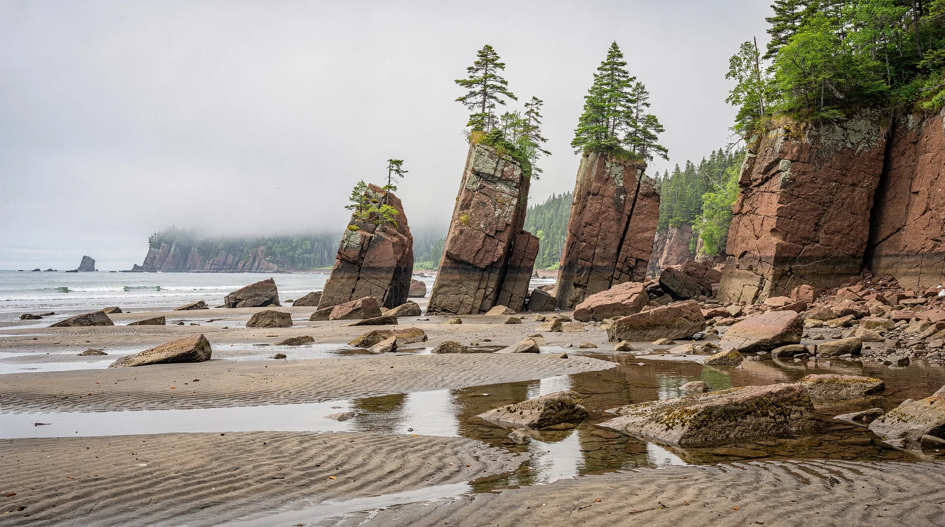
Hopewell Rocks sits on Shepody Bay, an inner arm of the Bay of Fundy, where tides reach 10-14 metres twice daily. Over millennia the incoming and outgoing tides have carved the red sandstone cliffs into the iconic Flower Pot formations — pillars of rock topped with spruce trees, standing on the ocean floor at low tide and surrounded by water at high tide.
Stand on the viewing platform above the Hopewell Rocks at mid-tide and you are looking at one of the most eloquent landscapes on the Atlantic coast. The burnt-red sandstone headlands have been sculpted by the Bay of Fundy into pillars, arches, and sea-stacks; the forest crowds right to the edge of the cliffs, stopping where the twice-daily flooding begins; the water below is the cloudy, cold brown of a bay in constant motion. In six hours the tidal line will climb or fall fifteen metres, and the whole geography of what you are looking at will change.
This guide is the broad hub to Hopewell Rocks — the geology, the history, the ecology, the Shepody Bay context, and how the site fits into a wider Bay of Fundy trip. If you are specifically planning the walk on the ocean floor, our companion guide to the Hopewell Rocks tidal walk covers tide schedules, timing, and what to wear.
What and where: Hopewell Rocks in one paragraph
Hopewell Rocks Provincial Park is a 2-km² coastal park on Route 114 in southern New Brunswick, approximately 40 km south of Moncton. It sits on the western shore of Shepody Bay — the northernmost arm of the Bay of Fundy, separating the Chignecto Peninsula from the mainland. The park protects a stretch of red sandstone cliffs and the “flowerpot” rock formations that stand on the beach at low tide. It is administered by a not-for-profit operator on behalf of the Province of New Brunswick and is one of the most-visited attractions in the Atlantic provinces, drawing roughly 250,000 visitors a season.
The Fundy tidal phenomenon: why tides here are so extreme
The Bay of Fundy records the largest tidal range on earth. At the head of the bay, in the Minas Basin, the peak vertical range reaches 16.3 metres — a measurement verified by the Guinness organisation. At Hopewell Rocks, slightly further north-west on Shepody Bay, the range is typically 10-14 metres, occasionally more on a spring tide.
Two factors produce this extraordinary range:
- Shape and depth. The Bay of Fundy funnels from a mouth roughly 100 km wide between Nova Scotia and Maine down to a narrow head at the Minas Basin. As tidal water is pushed in from the open Atlantic, it is compressed both laterally and vertically, amplifying the range.
- Resonance. The natural oscillation period of water in a basin of Fundy’s dimensions is approximately 13 hours — almost exactly the 12.4-hour period of the lunar semi-diurnal tide. The forcing tide and the bay’s natural frequency resonate, building the range to an extreme found nowhere else.
The practical consequence is that water enters Shepody Bay at speeds of several knots on the incoming flood, and the base of the Hopewell Rocks formations is submerged under up to 15 metres of water for roughly 4-6 hours of every tidal cycle, and fully exposed for another 2-4 hours.
Geology: how the Flower Pots formed
The rock at Hopewell is a red feldspathic sandstone deposited approximately 320-325 million years ago, during the late Carboniferous. At that time the area now known as New Brunswick lay close to the equator, in a series of river floodplains and deltas. The sandstone contains visible cross-bedding, pebble conglomerates, and occasional coal seams — all pointing to a fluvial, near-shore depositional environment.
The dramatic shapes of the Flower Pot rocks are the product of three processes acting in sequence:
- Sea-level rise. As the bay flooded after the end of the last ice age, rising water reached the cliff faces of the old sandstone headlands.
- Tidal erosion. Twice-daily tides, combined with storms, have battered the cliff base, cutting notches, arches, and sea caves. Because the lower sections are worked on more intensively than the higher, the cliffs have retreated unevenly, leaving towers and pillars of harder rock.
- Frost wedging and vegetation. In winter, water freezing in cracks prises blocks loose. Spruce and fir roots on top of the towers help stabilise the pillars while producing the distinctive flowerpot silhouette.
The formations are not static. Every few years a major collapse reshapes part of the shoreline. “Elephant Rock”, a well-known twin arch, lost a leg to collapse in 2016; other named pillars have vanished entirely since the park opened. On a geological timescale, the entire complex is ephemeral.
A short human history
The Mi’kmaq people have lived along the shores of Shepody Bay for thousands of years, and the red cliffs of Hopewell Cape are embedded in Mi’kmaq oral tradition. European settlement dates from the Acadian period in the late 17th century; the nearby village of Hopewell Cape was established in 1700. For much of the 19th and early 20th centuries, the economy of the area was tied to shipbuilding — the red sandstone shore provided sheltered building yards, and the Albert County region produced many of the wooden vessels that carried the Maritime economy.
The Hopewell Rocks site itself became a tourist destination in the late 19th century, when rail access from Saint John and Moncton brought day visitors to see the tidal phenomenon. The first formal management of the site began in the 1950s, and the modern park facilities (trails, stairways to the ocean floor, interpretation centre) date from a major investment in the 1990s.
Ecology of the intertidal zone
The intertidal zone at Hopewell Rocks is one of the most biologically productive environments on the Atlantic coast. The twice-daily tidal cycle delivers dissolved oxygen, suspended nutrients, and the fine sediment that sustains a dense bottom food web.
| Zone | Typical organisms | Where to look |
|---|---|---|
| Upper intertidal | Rockweeds, barnacles, common periwinkles | Splash zone at cliff base |
| Mid intertidal | Mussel beds, dog whelks, sea stars | Rocky outcrops on the floor |
| Lower intertidal | Kelps, tide-pool anemones, hermit crabs | Pools near the low-tide mark |
| Mud flats (Shepody Bay) | Corophium volutator (mud shrimp) | Extensive flats south of park |
The Corophium mud shrimp is the keystone species of the wider Shepody Bay food web. Roughly 2 million semipalmated sandpipers and other shorebirds stage at Shepody and the adjacent mud flats in late July and August, doubling their body mass on Corophium before flying non-stop to South America. The Shepody Bay and surrounding flats are designated a Western Hemisphere Shorebird Reserve. The shorebird migration is a secondary attraction worth timing a late-summer visit around.
Visiting the park: the essentials
This hub page summarises the practicals; the tidal walk guide has the full detail on timing the ocean floor window.
Access and opening
The park is open mid-May to mid-October; the interpretive centre, cafe, shuttle service, and stairs to the beach all operate during the season. Winter access is not permitted.
Admission (2026, approximate)
- Adult: CAD $14
- Youth 5-18: CAD $10
- Family: CAD $36
- Second-day pass: half price (ask at the gate on the way out)
Admission covers the interpretive centre, all trails, and the stairways to the ocean floor. The on-site kayak operation is a separate fee (CAD $65-80).
Facilities
A modern interpretive centre near the car park has geology and tides exhibits, washrooms, a cafe, and a well-stocked gift shop. A free shuttle runs from the centre down to the beach stairs, saving a 1-km walk each way. Strollers and wheelchairs can use the shuttle and the paved upper trails; the ocean floor itself requires stepping down a steep staircase and is not wheelchair accessible.
How long to stay
Most visitors spend 3-4 hours on site — 1.5-2 hours on the ocean floor at low tide, plus the clifftop trail and the interpretive centre. A full day is justified if you are combining the low-tide walk with a high-tide kayak tour.
Browse Bay of Fundy tours and Atlantic Canada experiencesNearby Bay of Fundy attractions
Hopewell Rocks is the anchor of a compact cluster of Bay of Fundy experiences that fit naturally into a 2-4 day Fundy loop from Moncton. All of the following are within 90 minutes’ drive.
Fundy National Park
Forty kilometres south on Route 114, Fundy National Park protects 206 km² of Acadian forest, coastal cliffs, and a network of 120 km of hiking trails. The main townsite at Alma has restaurants known for lobster rolls and chowder; the park campgrounds are among the best-maintained in the Atlantic provinces. Highlights include Point Wolfe, the Dickson Falls loop, and the Fundy Footpath for multi-day hikers.
Shubenacadie River tidal bore
A 90-minute drive east into Nova Scotia puts you on the Shubenacadie tidal bore rafting — riding the incoming tidal wave in motorised Zodiacs as it forces upriver against the outgoing current. It is a genuinely wild take on the same tidal phenomenon that produced the Hopewell Rocks.
Cape Enrage and the Fundy Trail Parkway
Between Hopewell Rocks and Fundy National Park, Cape Enrage (a 1870s-era lighthouse on a dramatic headland with rappelling and zipline operations) and the Fundy Trail Parkway (a 30-km scenic driving route along the coast) round out a two-day New Brunswick Fundy loop.
Moncton
Moncton itself is the main accommodation hub for Hopewell Rocks visitors. The city has the Petitcodiac River tidal bore (visible from downtown on favourable days), the Magnetic Hill optical illusion, and a good selection of Acadian restaurants. For a full trip template, see our Atlantic Canada 7-day itinerary.
When to visit: timing the season
The park season is mid-May to mid-October, but the quality of the experience varies by month.
- May (late): Opening fortnight; fewer visitors, sometimes cold (single-digit overnight lows), some facilities still ramping up. Low crowd levels reward early-season travellers.
- June: Warming, longer daylight, green and mossy on the floor. Generally excellent.
- July-August: Peak season. Busy, particularly weekends and favourable tide windows. Warmest water for kayaking.
- Late August: Start of the shorebird migration on the adjacent flats; great combination with birding at Mary’s Point and Johnson’s Mills.
- September: Best month in many views — warm days, cool nights, smaller crowds, autumn colour beginning in the Caledonia Highlands inland.
- Early October: Autumn colours peak; opening hours shorten. Check the park website before planning a tight schedule.
Frequently asked questions about Hopewell Rocks: geology, history & Bay of Fundy hub guide
Is Hopewell Rocks worth visiting at high tide?
Yes. The clifftop trail and the interpretive centre are open at any tide, and the high-tide view — when the Flower Pots become sea stacks — is itself memorable. High tide is also when the guided kayak tours run.
How does Hopewell compare with the Minas Basin side of the bay?
The Minas Basin (Nova Scotia) has the higher absolute tidal range (16.3 m vs. 10-14 m at Hopewell), but the Shepody Bay coast has the dramatic sculpted sandstone formations. The two sides are complementary; ambitious Fundy trips take in both.
When were the Flower Pots first formed?
In their current recognisable form, a few thousand years — since post-glacial sea level reached its present height. The underlying sandstone is 320 million years old, but the pillars themselves are young by geological standards and continuously reshaped.
Can I swim at Hopewell Rocks?
No. The tidal currents are hazardous and the water is cold. The park does not have a designated swimming beach. Warm-water swimming in the Bay of Fundy is limited to the Northumberland Strait coast, an hour north.
Are there guided tours of the park?
Yes. Park interpreters offer free short walks on the ocean floor during low-tide windows in peak season. Guided kayak tours (separate fee) run at high tide. Check the park website in advance for scheduled interpretive programs.