Sunshine Coast Trail: Canada's longest hut-to-hut hike
How long is the Sunshine Coast Trail?
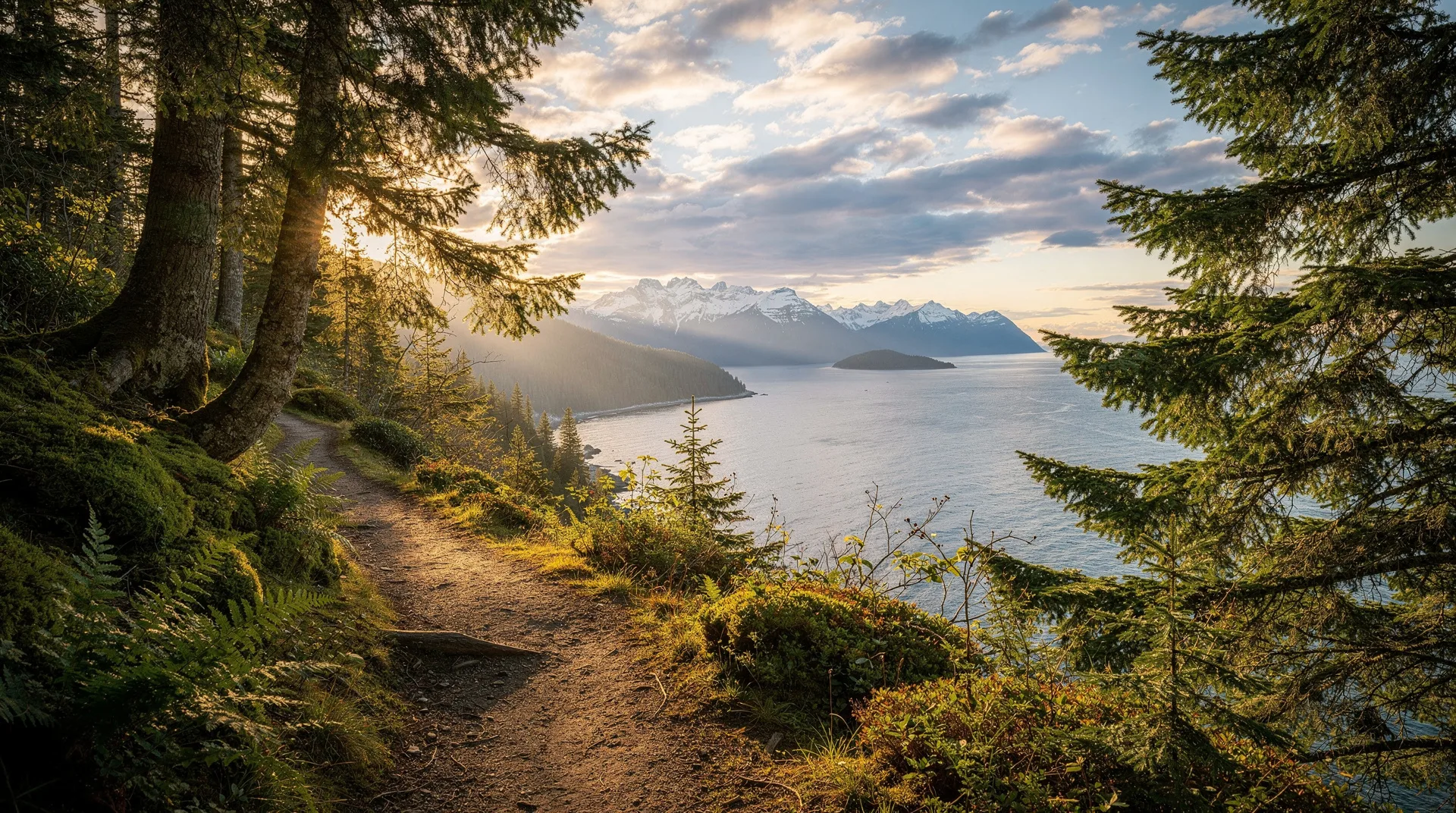
The Sunshine Coast Trail runs 180 km from Sarah Point in the north to Saltery Bay in the south, making it Canada's longest hut-to-hut hiking trail. It has 14 free-to-use huts along the route. End-to-end hikers typically take 10-14 days; section hikes of 2-4 days are also popular.
The Sunshine Coast Trail (SCT) is one of Canada’s most remarkable hiking infrastructures. At 180 km, it is the longest hut-to-hut trail in the country — and the longest purpose-built long-distance trail in BC. It runs from Sarah Point at the northern end of the upper Sunshine Coast, near Powell River, south to Saltery Bay at the southern terminus of the upper Sunshine Coast ferry connection. Along its length, 14 free-to-use huts provide overnight shelter — all built and maintained by the community-supported Powell River Parks and Wilderness Society (PRPAWS).
No permits are required. No fees are charged. Huts cannot be reserved but operate on a shared-access basis (always carry a tent as backup). The trail crosses ancient rainforest, summit ridges, coastal viewpoints, and freshwater lakes through some of the most undeveloped wilderness on the BC south coast.
For committed backpackers, this is one of Canada’s great long-distance trails — and yet, because it requires a floatplane or ferry to reach and is almost entirely unpublicised, it receives a tiny fraction of the attention given to the West Coast Trail or similar routes.
Trail overview
Total length: 180 km
Direction: Typically hiked south-to-north (Saltery Bay to Sarah Point) to end near Powell River services, but either direction works
Duration end-to-end: 10-14 days typical; faster hikers complete in 8 days
Huts: 14 along the route (5 summit huts; 9 general huts)
Permits: None required
Cost: Free (small voluntary donations requested to support hut maintenance)
Best season: June through mid-October
Access:
- Southern terminus: BC Ferries Saltery Bay (from Earls Cove)
- Northern terminus: Water taxi or hike from Lund to Sarah Point
The trail character
The Sunshine Coast Trail is genuine backcountry. Unlike established national park trails, the SCT is built and maintained by volunteers, is marked with painted blazes rather than extensive signage, and crosses working forestry land in places where trail conditions can vary with recent logging. The terrain is forested and moderate — significant elevation gain and loss throughout, but no extreme exposure or alpine technicality.
The defining features are:
- 14 free huts — small, functional, no reservation, first-come-first-served
- Summit huts — positioned on Confederation Lake, Tin Hat Mountain, Mount Troubridge, Walt Hill, and Mount Mahony
- Coastal sections near Sarah Point and the northern third
- Old-growth rainforest protected in several sections
- Multiple lakes — Eagle Lake, Walt Hill, Inland Lake, Lois Lake
Huts along the trail (south to north)
- Fairview Bay — near Saltery Bay; coastal views
- Rainy Day Lake
- Walt Hill — summit hut with viewpoint
- Elk Lake
- Mount Troubridge — summit hut
- Fiddlehead Landing
- Tin Hat Mountain — summit hut with extraordinary 360° views
- Confederation Lake — summit hut
- Anthony Island — on Inland Lake
- Lang Lake
- Sliammon Lake
- Emma Lake — on Mount Mahony
- Manzanita Hut — on Mount Mahony summit
- Sarah Point — at the northern terminus
Huts vary in size from small lean-to shelters to larger cabin-style buildings sleeping 8-12. In peak season, summit huts can fill early — carry a tent as backup.
Typical itinerary (south to north, 12 days)
| Day | Section | Distance | Overnight |
|---|---|---|---|
| 1 | Saltery Bay to Fairview Bay | 10 km | Fairview Bay Hut |
| 2 | Fairview Bay to Rainy Day Lake | 16 km | Rainy Day Lake Hut |
| 3 | Rainy Day Lake to Walt Hill | 14 km | Walt Hill Summit Hut |
| 4 | Walt Hill to Elk Lake | 15 km | Elk Lake Hut |
| 5 | Elk Lake to Mount Troubridge | 14 km | Mount Troubridge Hut |
| 6 | Troubridge to Fiddlehead Landing | 14 km | Fiddlehead Hut |
| 7 | Fiddlehead to Tin Hat Mountain | 14 km | Tin Hat Summit Hut |
| 8 | Tin Hat to Confederation Lake | 18 km | Confederation Lake Hut |
| 9 | Confederation Lake to Anthony Island | 15 km | Inland Lake (Anthony Island) |
| 10 | Anthony Island to Lang Lake | 16 km | Lang Lake Hut |
| 11 | Lang Lake to Emma Lake | 18 km | Emma Lake Hut |
| 12 | Emma Lake to Sarah Point | 16 km | Water taxi back to Lund |
This pace is moderate; faster hikers compress to 10 days, and slower hikers spread to 14.
Section hikes for shorter trips
Tin Hat Mountain (2-3 days)
The most scenic section of the trail. Access from Inland Lake Provincial Park (Powell River) to Tin Hat Mountain via the north slope.
- Day 1: Inland Lake Campsite to Confederation Lake Hut — 15 km
- Day 2: Confederation Lake to Tin Hat Summit Hut — 18 km. Spend the afternoon at the 360° summit viewpoint.
- Day 3: Return to Inland Lake via same route — longer day, but downhill-weighted.
Mount Troubridge (3-4 days)
Access from Saltery Bay.
- Day 1: Saltery Bay to Fairview Bay — 10 km
- Day 2: Fairview Bay to Walt Hill — 30 km (long day; or split to Rainy Day Lake then Walt Hill)
- Day 3: Walt Hill to Mount Troubridge — 29 km (again, long; or split at Elk Lake)
- Day 4: Return or continue
Inland Lake Loop (day hike)
A 13-km loop around Inland Lake from Powell River — completely flat, suitable for families.
Planning logistics
Getting to the trail
Saltery Bay (southern terminus): BC Ferries from Earls Cove on the lower Sunshine Coast (Hwy 101). From Vancouver: ferry Horseshoe Bay to Langdale (40 min), drive Hwy 101 to Earls Cove (1.5 hrs), ferry to Saltery Bay (50 min). Approximately 4-5 hours from downtown Vancouver.
Sarah Point (northern terminus): No road access. From Lund (25 min north of Powell River), water taxi or boat charter. Lund Water Taxi runs scheduled and charter services.
Getting to Powell River
Powell River is served by:
- BC Ferries from Comox (1h 20 min) — easier from Vancouver Island
- Pacific Coastal Airlines from Vancouver YVR to Powell River Airport
- BC Ferries from Saltery Bay (onto Hwy 101 for the upper Sunshine Coast)
See the BC Ferries guide for booking.
Gear and preparation
This is genuine backcountry. Essentials include:
- Full backpacking kit: backpack, tent (backup for full huts), sleeping bag rated to 0°C, sleeping mat
- Stove and fuel — wood fires are forbidden in huts; all cooking on stove
- Water filter — streams and lakes throughout
- Bear spray — black bears are common; grizzlies are rare but possible
- Maps and compass — trail blazes are the primary markers; GPS coordinates downloaded from sunshinecoast-trail.com
- Sturdy boots — trails are rough, muddy, and rocky in places
- Rain gear — the BC coast is wet even in summer
- Food for all days — no resupply points (some hikers arrange food caches with local contacts)
Water, food, and waste
Water: Purify all water from streams and lakes. Huts often have nearby water sources but not always reliable.
Food: Pack all food; no resupply on trail. Some hikers arrange a food cache midway via local contacts.
Waste: Pack out all trash. Pit toilets exist at most huts.
Fires: Campfires are generally prohibited or restricted. Huts have no chimneys for cooking fires — use camp stoves only.
Trail condition and seasonality
Best window: Mid-June to mid-September. Early June can have snow on the highest sections (Walt Hill, Troubridge, Tin Hat). Late September brings cold nights and possibly early snow.
Winter: The trail is not maintained for winter use. Some lower sections remain accessible to snowshoers; summit sections become genuinely dangerous in winter.
Rain: Persistent rain is possible in any season. Wet boots, trails, and general mud are part of the experience.
Bugs: Mosquitoes and black flies peak in June and early July in forested sections.
PRPAWS and supporting the trail
The Powell River Parks and Wilderness Society (PRPAWS) is the volunteer organisation that built and maintains the trail. They rely on donations and volunteer labour. If you hike the SCT, consider a donation — sunshinecoast-trail.com has details. The trail is free to use precisely because volunteers maintain it.
Connecting the SCT with other BC trails
For committed long-distance hikers, combinations include:
- Sunshine Coast Trail + West Coast Trail — two very different 6-8 day BC backpacking experiences back-to-back
- SCT + North Coast Trail — the remote Vancouver Island wilderness trail
- SCT followed by Gulf Islands exploration — a wilderness-to-island-hopping transition
Frequently asked questions about Sunshine Coast Trail: Canada’s longest hut-to-hut hike
Is the Sunshine Coast Trail really free?
Yes. No permits, no fees, no reservations. The trail is maintained entirely by the volunteer PRPAWS organisation, which accepts voluntary donations but does not charge users.
Are the huts reservable?
No. Huts operate on a first-come, first-served basis. In peak season (July-August), summit huts can fill — always carry a tent as backup.
How does the SCT compare to the West Coast Trail?
The West Coast Trail is shorter (75 km), more technical (ladders, cable cars, extensive mud), more crowded, and permitted/limited. The SCT is longer (180 km), more scenic in its variety (coastal, forest, alpine, lake), less technical, less crowded, and free. The WCT is more famous; the SCT is arguably more rewarding for experienced backpackers.
Can I hike just a section?
Yes — section hiking is common. Tin Hat Mountain (2-3 days), Troubridge (3-4 days), and Walt Hill (weekend overnight) are the most popular section options. See the PRPAWS website for detailed section guides.
Is the Sunshine Coast Trail suitable for beginners?
Not for complete beginners. The trail requires backcountry skills: navigation, water purification, bear safety, multi-day backpack management. But it is approachable for reasonably fit hikers with some prior multi-day experience. Not technical or exposed like alpine mountaineering.
What wildlife might I encounter?
Black bears are common. Cougars are present but rarely seen. Wolves, wolverines, and mountain goats (at higher elevations) are possible. Deer, marmots, grouse, and the usual smaller fauna are routine. Carry bear spray and know how to use it.