West Coast Trail: the complete hiker's guide
How hard is the West Coast Trail?
The West Coast Trail is rated difficult to very difficult. The 75 km route typically takes 6–8 days, with daily distances of 8–16 km on terrain that includes ladders, boardwalks, beach crossings, river crossings by cable car, and extensive mud. Fitness is required, but technique matters more than speed.
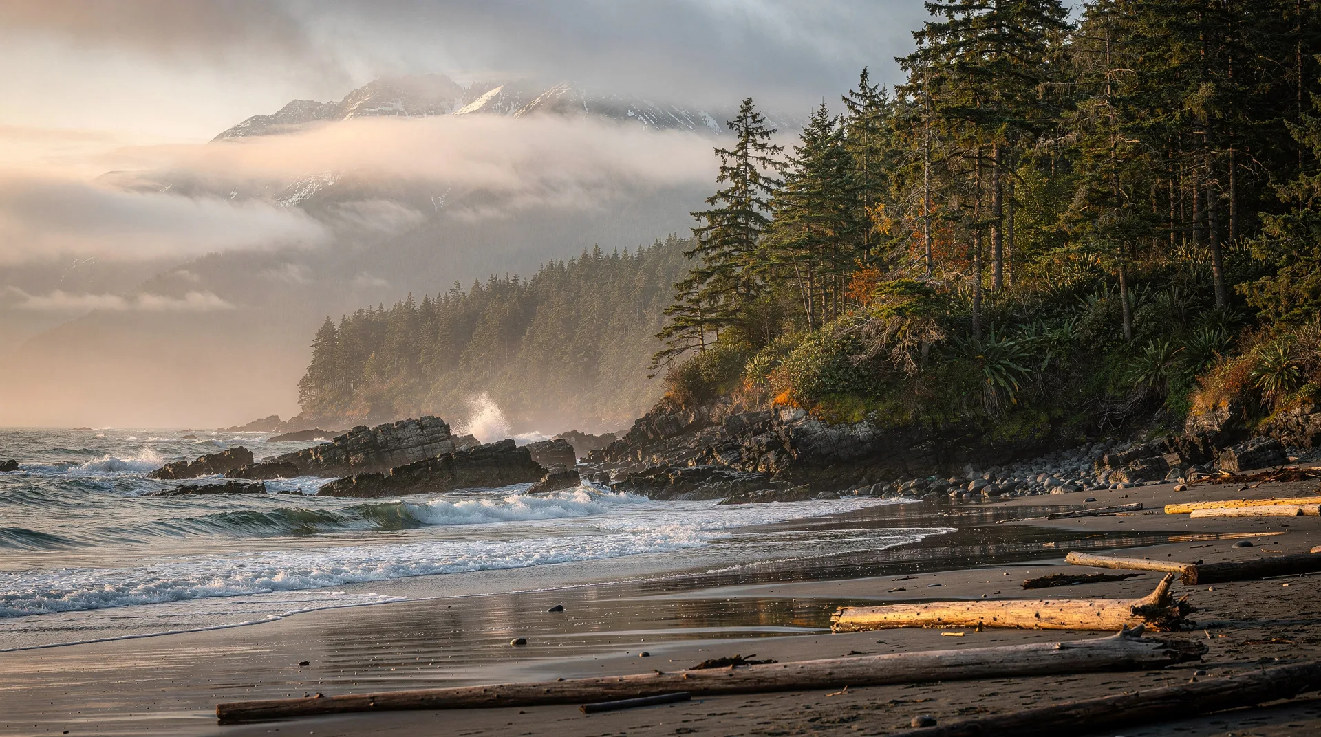
The West Coast Trail is not a hiking trail. Not exactly. It is a survival route turned pilgrimage — 75 kilometres of Vancouver Island’s outer coast that was originally cut through the rainforest to allow survivors of shipwrecks to reach help. The “graveyard of the Pacific” was so named because the combination of submerged rocks, fierce currents, and Pacific swells sank hundreds of ships in the 19th and early 20th centuries, and the trail was the only way out for those who made it to shore alive.
Today the trail is the most demanding and most celebrated multi-day hike in British Columbia. Parks Canada manages it as a limited-access backcountry experience through Pacific Rim National Park Reserve, with a strict quota of 75 hikers per day (split between the two trailheads). Completing the WCT earns a level of respect in BC’s hiking community that very few other trails can claim.
It is also genuinely beautiful. Old-growth rainforest, sea stacks, tide pools, kelp forests, sea caves accessible at low tide, waterfalls that drop directly onto beaches — the coastal scenery is relentless. Bald eagles are a daily presence. Pacific grey whales feed in the kelp beds offshore. Sea lions haul out on rocks. Sitka spruce trees more than 800 years old stand in the rainforest interior. The West Coast Trail is as much a wildlife experience as a hiking one.
Route overview
The trail runs between Pachena Bay (near Bamfield) at the north end and Gordon River (near Port Renfrew) at the south end. It is linear — you start at one end and finish at the other, requiring either vehicle shuttle, water taxi, or return bus transportation.
Most hikers travel south to north (Gordon River to Bamfield), as this direction saves the more technical southern terrain for when fitness is highest in the first few days. North to south is equally valid and splits the route in a different psychological direction.
The trail divides into two character zones:
South section (Gordon River to Nitinat Narrows, approximately 33 km): The harder section. More ladder descents, more mud, more complex route-finding, more technical terrain. The famous 73-metre ladder descent to Cullite Creek and the Logan Creek cable car crossing are in this zone. This section rewards patience and punishes rushing.
North section (Nitinat Narrows to Pachena Bay, approximately 42 km): More beach walking, faster progress, but still demanding. The 17 km Pachena Beach section near the north end is flat and fast, offering a welcome change of pace after the technical south. Michigan Creek to Tsusiat Falls is one of the finest sections on any multi-day trail in Canada.
The permit system
Parks Canada operates a strict reservation system for the West Coast Trail.
Season: May 1 to September 30. The trail is not maintained or patrolled outside this window and is extremely hazardous in winter conditions.
Daily quota: 75 people per day, split between the two trailheads (typically 26 from Gordon River, 26 from Pachena Bay, with some flexibility).
Reservation: Opens in January for the following season through the Parks Canada reservation system. The most popular summer start dates sell out within hours of opening. Register for a Parks Canada account in advance and be online at the opening time.
Cost: Approximately CAD 250–280 per person (includes a reservation fee, trail use fee, and ferry crossing fees at Nitinat Narrows and Gordon River). These fees change slightly year to year — check the Parks Canada WCT page for current rates.
Orientation session: All hikers must attend an orientation session at the trailhead (approximately 90 minutes) before starting. The sessions cover route hazards, tides, emergency procedures, and wildlife. They are mandatory, not optional.
Physical preparation
The West Coast Trail requires a minimum of 4–6 months of preparation for those not already in hiking shape. It is not a trail for casual hikers or those whose primary exercise is walking to coffee shops.
What to train:
- Carrying load: You will carry 15–25 kg for 6–8 days. Train with a loaded pack — do not just train unloaded.
- Daily mileage with elevation: Practice hiking 8–15 km per day on consecutive days. The cumulative fatigue matters more than any single day’s fitness.
- Stair and ladder work: The trail has over 100 ladders. Practice ladder technique on any available structure.
- Wet conditions: Train in rain gear and with wet feet — you will be wet for portions of most days.
A realistic preparation program involves 3–4 days of hiking per week for three months before the trip, including at least two multi-day overnight trips with a full load.
Gear list
Essential items:
- Backpack 60–75L with rain cover
- Tent rated for wet coastal conditions (seam-sealed, waterproof fly)
- Sleeping bag rated to 0°C minimum
- Sleeping pad (closed-cell foam or inflatable)
- Rain gear: jacket and pants (Gore-Tex or equivalent — this is not a place for cheap rain gear)
- Gaiters (essential — the mud is extraordinary)
- Hiking boots that are waterproof and broken in
- Camp shoes or sandals (for river crossings and camp)
- Trekking poles (critical for ladder descents and beach boulder walking)
- Water filter or purification tablets
- Camp stove and sufficient fuel for 7–8 days
- 7–8 days of food (no resupply on trail except the Nitinat Narrows First Nations store, which has limited supplies)
- Bear canister or PCT-certified food storage (required in some zones)
- Headlamp with spare batteries
- First aid kit (comprehensive — you are 2–3 days from evacuation)
- Emergency whistle, compass, WCT map
- Tide tables (printed — essential for beach route timing)
Tide tables: Many sections of the trail route along beaches that are impassable at high tide. The WCT requires reading and following tide tables every single day. Parks Canada provides these at orientation; also download and print a copy before you go.
Key sections and highlights
Gordon River cable car and first kilometres (south start)
The trail begins with a vehicle ferry across the Gordon River (CAD 16 each way, cash only) and immediately confronts you with the character of the southern section: root-covered trail, mud, ladders. The first day establishes the pace quickly. Expect to cover 8–10 km in 5–7 hours.
Cullite Creek and the 73-metre ladder
The descent to Cullite Creek involves the longest single ladder descent on the trail — 73 vertical metres on bolted wooden ladders. This section is the most frequently discussed obstacle on the WCT and while intimidating in description, is manageable with careful technique. Lower your pack separately from yourself on these descents if you are uncomfortable with the exposure.
Nitinat Narrows ferry
At approximately the halfway point, a short water taxi operated by the Ditidaht First Nation crosses Nitinat Narrows — a mandatory crossing that cannot be waded and operates on a schedule. The small store at the narrows sells fresh salmon (when available) and basic supplies. This is the only resupply point on the trail, and the Ditidaht ferry is one of the genuinely memorable moments of the WCT.
Tsusiat Falls
Tsusiat Falls drops 40 metres directly onto a beach, with a large camping area at the base. It is the most photographed campsite on the WCT and deservedly so — the combination of old-growth forest, waterfall, and open beach is spectacular. Camp here if the permit system allows.
Pachena Beach and the finish
The final 17 km to Pachena Bay includes the longest beach section on the trail — flat, fast walking on sand with sea views and often excellent wildlife sightings (grey whales in spring, bald eagles throughout). The approach to Pachena Bay Lighthouse is one of the most emotionally satisfying moments in BC hiking: the realisation that you are nearly finished something genuinely difficult.
Wildlife
The WCT passes through some of the richest temperate coastal wildlife habitat in North America. Regular sightings include:
- Pacific grey whales (March–May, feeding in kelp beds offshore)
- Bald eagles (year-round, multiple per day)
- Black bears (common near creek mouths and berry patches — store food in bear caches)
- Sea lions (Steller’s, hauled out on sea stacks)
- Harbour seals (very common along the coast)
- River otters (at creek mouths)
- Wolves (the WCT coastline supports a coastal wolf population — sightings occasional but real)
Getting there
Gordon River (south) trailhead: Port Renfrew is 107 km from Victoria on Highway 14 (approximately 2.5 hours). A shuttle service operates from Victoria in season.
Pachena Bay (north) trailhead: Bamfield is accessible by road from Port Alberni (approximately 2 hours on a gravel road) or by the MV Frances Barkley passenger ferry from Port Alberni (Tuesdays, Thursdays, Saturdays in season).
Port Alberni connection: Most hikers use Port Alberni as the logistics hub — the West Coast Trail Express shuttle bus connects Port Renfrew, Port Alberni, and Bamfield in season, making the vehicle-free trailhead-to-trailhead experience straightforward.
Accommodation before and after
Port Renfrew: Coastal Kitchen Cafe and Pacheedaht Campground are the most popular pre-hike stays at the Gordon River end.
Bamfield: The Bamfield Lodge is the best accommodation at the north trailhead. Limited options — book well ahead.
Victoria: For a comfortable pre-trip base with access to all supplies, Victoria is ideal. See the whale watching in Victoria guide for a sense of the city’s character and accommodation range.
Explore tours and experiences in Victoria, BCRelated trails
The Juan de Fuca Trail runs parallel to the south end of the WCT, from Botanical Beach near Port Renfrew northward to China Beach. It is shorter (47 km), does not require a reservation, and offers a taste of WCT-style coastal terrain at a fraction of the logistics complexity. See the Juan de Fuca Trail guide for details.
Frequently asked questions about West Coast Trail: the complete hiker’s guide
How many days does the West Coast Trail take?
Most hikers complete the trail in 6–8 days. Strong, experienced hikers cover it in 5 days; those prioritising enjoyment over speed take 8–10. Seven days is the most common duration, with daily distances of 10–15 km.
Can I do the WCT alone?
Technically yes — solo hiking is permitted. Parks Canada recommends groups of 2–4 for safety. Solo hiking on the WCT requires additional experience in self-rescue, navigation, and emergency response. Evacuation from the southern section can take 2–3 days in bad weather. If you hike solo, file a detailed trip plan with someone reliable.
What if I have to be evacuated?
Parks Canada has a marine-based emergency response system. Emergency shelters (orange triangles) are spaced along the trail and mark evacuation points. Evacuation costs are not covered by Parks Canada — comprehensive travel insurance with wilderness rescue coverage is strongly recommended.
What happens if I miss my reservation?
You lose your spot. Transfers to another date or refunds are not typically available for missed reservation start dates. This is why planning the Port Renfrew or Bamfield pre-night accommodation is important — delays in getting to the trailhead can cascade.
Is the WCT suitable for teenagers?
Yes, for physically capable and experienced teen hikers (typically 14+) who have done multi-day hiking with a full load before. The WCT requires mental resilience as much as physical fitness — knowing how to manage discomfort, wet conditions, and heavy terrain day after day is something that develops through experience, not just fitness.