St. Lawrence Ferry Routes: Matane, Baie-Comeau, Rivière-du-Loup
Can you take a ferry across the St. Lawrence River in Quebec?
Yes. Three main ferry routes cross the St. Lawrence: Rivière-du-Loup to Saint-Siméon (1h20m), Matane to Baie-Comeau and Matane to Godbout (2h30m and 2h20m respectively), and the free Tadoussac–Baie-Sainte-Catherine crossing (10 minutes). These ferries save significant driving distance and provide excellent river views. Booking ahead is recommended in summer.
The St. Lawrence River is one of the most significant geographic features in Quebec travel — it separates the province’s north shore from its south shore, and driving around it rather than across it can add hundreds of kilometres to a journey. Three commercial ferry routes cross the St. Lawrence at useful points for travellers, and the free Saguenay River crossing at Tadoussac is essential for north shore travel. This guide covers each route in practical detail.
Why the ferries matter for Quebec travellers
The St. Lawrence River widens dramatically as it moves northeast from Quebec City. By Rivière-du-Loup, the river is over 30 kilometres wide. By Matane, it approaches 50 kilometres. There is no bridge across the river east of Quebec City — the only fixed crossing in this zone is the bridge at the island of Île d’Orléans (which connects the island but not the main north and south shores). For anyone travelling between the north shore (Charlevoix, Côte-Nord) and the south shore (Gaspésie, Bas-Saint-Laurent), the ferry routes offer a practical and scenic alternative to long driving detours.
The ferries also carry their own appeal as experiences: crossing the St. Lawrence on a calm July morning, with the north shore mountains visible and the possibility of beluga or minke whales surfacing in the shipping channel, is one of the province’s quiet pleasures.
Route 1: Rivière-du-Loup to Saint-Siméon
Operator: Groupement maritime (formerly Les Traversiers du Québec operated by regional consortium)
Route: From the south shore town of Rivière-du-Loup across to Saint-Siméon in the Charlevoix region on the north shore.
Crossing time: Approximately 1 hour 20 minutes.
Distance saved: Driving from Rivière-du-Loup to Saint-Siméon without the ferry requires going west to Quebec City and back east — approximately 330 kilometres extra. The ferry crossing eliminates this entirely.
When to use this ferry
This crossing is most useful for:
- Travellers beginning a Charlevoix or Côte-Nord trip from the south shore corridor (arriving via Highway 20 from Montreal)
- Travellers returning from the Gaspésie to Quebec City or Montreal who want to cross to the north shore at Charlevoix rather than driving the full south shore
- Anyone whose itinerary connects the Bas-Saint-Laurent south shore to Charlevoix
Practical details
Schedule: Multiple crossings daily in summer (June through September), reduced frequency in shoulder and winter seasons. The schedule changes seasonally — consult the operator’s website for current timetables before planning.
Vehicle booking: Passenger vehicles can be carried. Vehicle reservations are strongly recommended for summer crossings (particularly July and August weekends) as space is limited. Foot passengers do not typically require reservations.
Fares: Approximate 2026 fares (verify current rates with operator):
- Adult foot passenger: CAD 18–22 each way
- Vehicle and driver (standard car under 6m): CAD 65–80 each way
- Additional adult passengers in vehicle: CAD 12–16 each
Weather: The crossing can be cancelled or delayed in severe weather — high winds and rough conditions can make the St. Lawrence crossing impractical. In winter, ice conditions occasionally affect service. Check the operator’s website or 511 for service updates.
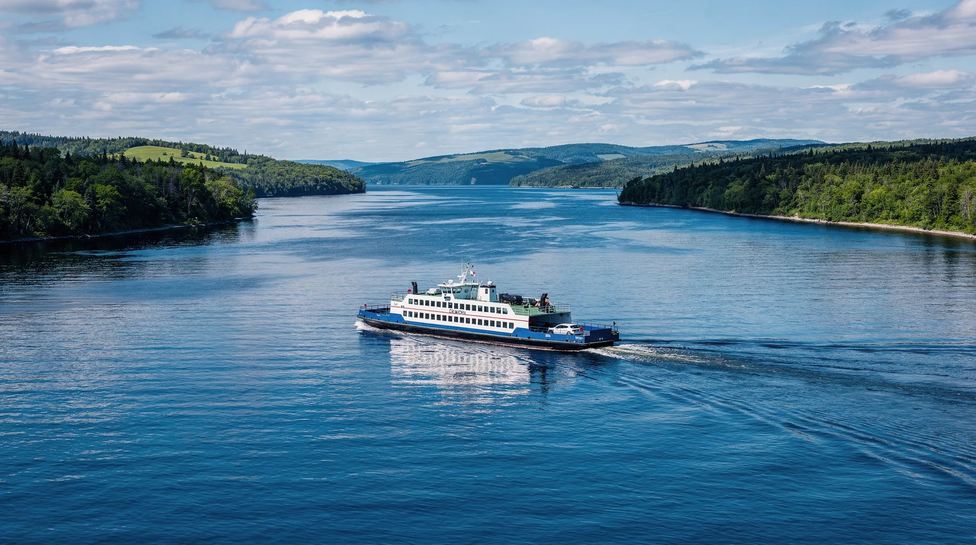
Route 2: Matane to Baie-Comeau and Matane to Godbout
Operator: Société des traversiers du Québec (STQ) — the provincial ferry operator
Routes: Two crossings from Matane on the south shore:
- Matane to Baie-Comeau (north shore, approximately 220 kilometres west of Sept-Îles)
- Matane to Godbout (north shore, approximately 30 kilometres east of Baie-Comeau)
Crossing time:
- Matane–Baie-Comeau: approximately 2 hours 30 minutes
- Matane–Godbout: approximately 2 hours 20 minutes
When to use these ferries
These crossings are essential for the Gaspésie and Côte-Nord itinerary and the 21-day Quebec grand tour. Specifically:
- The Matane–Baie-Comeau ferry allows travellers doing the Gaspésie loop to transition from the Gaspésie north coast to the Côte-Nord without backtracking through Quebec City — a saving of approximately 600 kilometres of driving
- Travellers doing the Côte-Nord drive who want to return to the Gaspésie at the most efficient geographic point use Matane as the south shore terminus
Without these ferries, completing a Gaspésie-plus-Côte-Nord circuit by road would require driving entirely back through Quebec City — an impractical detour for any itinerary.
Practical details
Schedule: The Société des traversiers du Québec operates this crossing. Frequency varies significantly by season: in peak summer, two to three crossings per day in each direction. In winter, one or two per day. The schedule is published well in advance on traversiers.com.
Vehicle booking: Essential for summer travel, particularly July and August. The ferry has limited vehicle capacity and fills quickly on peak days. Book vehicles as soon as your travel dates are confirmed. Foot passengers typically have more flexibility.
Fares (approximate 2026):
- Adult foot passenger: CAD 20–25 each way
- Vehicle under 6m and driver: CAD 70–90 each way
- Additional passengers: CAD 13–18 each
The ferry vessel: The STQ operates the NM F.-A.-Gauthier on this route (with operational schedules that may shift seasonally). The vessel has enclosed passenger decks with seating, a cafeteria service (basic but functional), and outdoor observation decks. The cafeteria serves hot food — bring your own snacks and drinks if quality is important.
Winter considerations: Ice conditions in the St. Lawrence east of Quebec City can affect the Matane crossing more significantly than the Rivière-du-Loup route, which is in a narrower, faster-flowing section. The STQ publishes real-time service status. Winter crossings are generally reliable but delays and cancellations are more frequent than in summer.
Route 3: Tadoussac–Baie-Sainte-Catherine (free, government-operated)
Operator: Ministère des Transports du Québec
Route: From Baie-Sainte-Catherine on the north bank of the Saguenay River (accessible from Route 138 heading northeast from Quebec City/Charlevoix) to Tadoussac on the south bank.
Crossing time: Approximately 10 minutes.
Cost: Free for all vehicles and passengers.
Why this crossing matters
This free ferry is not a strategic route-savings option — it is simply the only way to cross the Saguenay Fjord mouth and continue northeast on Route 138 toward the Côte-Nord. There is no bridge here. The free government ferry runs year-round and is, in practice, part of the highway.
For travellers visiting Tadoussac for whale watching from the Charlevoix side, the ferry brings you directly into the town. For those continuing northeast on Route 138 toward Baie-Comeau and Sept-Îles, the ferry is the necessary link in the highway.
Practical details
Frequency: Runs approximately every 20 minutes during peak hours in summer, reducing to every 40–60 minutes at night and in winter. The ferry operates 24 hours.
Vehicle capacity: Standard municipal car ferries carrying approximately 30–40 vehicles per crossing. No booking is required or available — first come, first served. In peak summer (July and August), waits of one to three departures are common at the Baie-Sainte-Catherine (south bank) loading point during peak arrival times (10am–4pm). Early morning crossings have minimal wait times.
The crossing itself: The 10-minute crossing traverses the mouth of the Saguenay Fjord — dramatic sheer rock walls rise on both sides, and the cold, dark water of the fjord mixes visibly with the warmer brown St. Lawrence. Beluga whales pass through this crossing regularly, and the Pointe-Noire Parks Canada facility on the Baie-Sainte-Catherine side has elevated viewing platforms specifically for beluga observation. If you have flexibility in timing, park at the Pointe-Noire facility before or after taking the ferry to scan for belugas from shore.
Additional St. Lawrence crossings
Île d’Orléans bridge (free)
The bridge from Highway 40 onto the island of Île d’Orléans (approximately 15 kilometres east of Quebec City) is the one fixed crossing of the broader St. Lawrence east of the capital. This is not a river crossing in the full sense — Île d’Orléans is an island in the river — but the bridge provides access to the island’s agricultural circuit and the view of Montmorency Falls from the island’s western tip. No ferry is involved; it is a standard bridge.
Île aux Coudres ferry (free)
A small free government ferry connects the village of Saint-Joseph-de-la-Rive on Route 362 in Charlevoix to the island of Île aux Coudres. The crossing takes approximately 15 minutes. The island (26 kilometres of flat farmland, windmills, and a heritage cider house) is worth a half-day excursion if passing through Charlevoix.
Planning considerations: which crossing to use
| Scenario | Recommended crossing |
|---|---|
| Connecting Charlevoix to Bas-Saint-Laurent south shore | Rivière-du-Loup – Saint-Siméon |
| Gaspésie loop to Côte-Nord connection | Matane – Baie-Comeau |
| Visiting Tadoussac from Charlevoix | Tadoussac – Baie-Sainte-Catherine (free, on route) |
| Côte-Nord to Gaspésie return | Matane – Godbout |
| Quebec City to Charlevoix with island detour | Île aux Coudres ferry from Saint-Joseph-de-la-Rive |
Related guides
- Via Rail within Quebec: Montreal to Quebec City, Gaspé and beyond
- Quebec entry gateways: Montreal, Quebec City or Ottawa airports
- 14 days in Quebec: complete province grand tour including Gaspésie
- Gaspésie Peninsula 7-day driving loop
Frequently asked questions about St. Lawrence Ferry Routes: Matane, Baie-Comeau, Rivière-du-Loup
Do I need to book the St. Lawrence ferry in advance?
For vehicle crossings in July and August on the Rivière-du-Loup and Matane routes, advance booking is strongly recommended. Vehicles book up, particularly on weekend departures, and arriving without a reservation can mean waiting for a later sailing with uncertain availability. Foot passengers have more flexibility but benefit from checking departure schedules. The Tadoussac–Baie-Sainte-Catherine ferry is first come, first served with no booking available.
Can I take my campervan or motorhome on the St. Lawrence ferries?
Yes, on both the Rivière-du-Loup and Matane routes. Oversized vehicles (over standard car dimensions) carry a surcharge based on length. Contact the operator directly when booking to confirm capacity and current rates for your vehicle dimensions.
Are the ferries comfortable for long crossings?
The Matane crossings (2.5 hours) have enclosed passenger decks with seating, tables, cafeteria service, and outdoor viewing areas. They are functional rather than luxurious — bring books, snacks, and a warm layer for the outdoor decks. The Rivière-du-Loup crossing (1h20m) has similar facilities. Both crossings are excellent opportunities to watch for wildlife — belugas, porpoise, and occasionally fin or minke whales are visible in the shipping channel during summer months.