Kootenay National Park guide: Radium Hot Springs, Paint Pots and BC canyon trails
What is Kootenay National Park known for?
Kootenay National Park in British Columbia is home to Radium Hot Springs — the largest natural hot springs pools in Canada — and the ochre Paint Pots, colourful mineral springs sacred to First Nations peoples. The park occupies a dramatic east-west corridor through the Rocky Mountains connecting Banff to the BC interior.
Kootenay National Park is the hinge that joins the Canadian Rockies to the Columbia River valley, a 1,406-square-kilometre corridor of mountains, canyons, and rivers following the Kootenay and Vermilion rivers through a spectacular east-west gash in the Continental Divide. Highway 93, the Kootenay Parkway, threads through the park from the Alberta boundary — where it connects directly to Banff National Park — to the town of Radium Hot Springs at the western gateway. The drive alone, 105 kilometres of mountain scenery, would justify the park’s existence. The hiking, wildlife, and the extraordinary Radium Hot Springs add reasons to linger.
The park was established in 1920 as part of an agreement with British Columbia: the federal government would build and maintain a road through the wilderness (the forerunner of the Kootenay Parkway) in exchange for a 5-mile-wide strip of land on either side of the road. The resulting long, narrow park shape — unusual among Canadian national parks — means that almost every point of interest is accessible directly from the highway corridor. Unlike the vast backcountries of neighbouring Jasper National Park or Kluane, Kootenay concentrates much of its most spectacular scenery within a short walk of the road.
The park’s position on the western slope of the Rockies gives it a slightly milder and wetter climate than Banff, producing lush subalpine fir forests and wildflower meadows that complement the dramatic canyon and cliff scenery. Kootenay is also one of the only national parks in the world to contain both glaciers and cacti — the Rocky Mountain prickly pear cactus grows on south-facing grassland slopes near Radium, benefiting from the warm, dry Columbia Valley climate at the park’s western end.
The crossroads of the Canadian Rockies
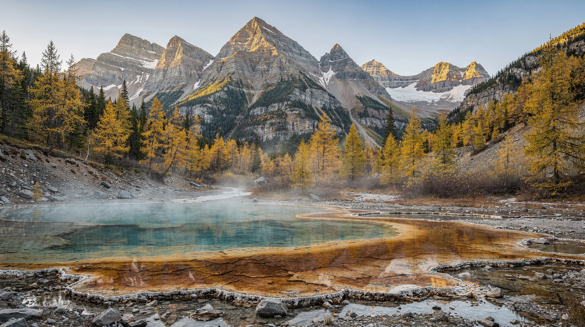
The Kootenay Parkway passes through a remarkable sequence of geological and ecological zones as it crosses the Continental Divide from Alberta into British Columbia. At the Alberta boundary, the terrain is typical upper Rockies — limestone peaks, spruce-fir forest, and braided glacial rivers. Marble Canyon, a few kilometres into the park from the east, introduces the theme of dramatic water carving: a narrow gorge of blue-grey limestone cut 37 metres deep by Tokumm Creek, with turquoise water rushing below. The Paint Pots, a short walk further west, present a scene of ochre and red mineral springs completely unlike anything else in the mountain parks.
As the highway descends westward toward the Columbia Valley, the forest transitions from boreal spruce-fir to the drier ponderosa pine and Douglas fir associations of the BC interior. By the time the road reaches Radium, the landscape is recognizably different from Banff — warmer, drier, with grassland slopes and a broader valley floor. This ecological gradient makes Kootenay one of the most biodiversity-rich areas in the Rocky Mountain parks.
The hot springs at Radium — the largest natural hot springs pools in Canada — have been drawing visitors for well over a century. The springs issue from the base of the Redwall Fault at the bottom of the Sinclair Canyon, with a flow rate of over 40 litres per second of mineral-rich water at a natural temperature of 44°C. Parks Canada channels the springs water into two outdoor pools at the Radium Hot Springs Aquacourt: a hot pool and a cooler swimming pool. Soaking in the outdoor pools as steam rises over the canyon walls and peaks above is one of the definitive Rocky Mountain park experiences.
Top things to do in Kootenay National Park
Soak in Radium Hot Springs
The Radium Hot Springs Aquacourt is the park’s most popular attraction and one of the most enjoyable amenities in the Canadian Rockies. The hot pool (39°C) and the cooler swimming pool (27°C) are open year-round, with swimming and soaking equally popular in summer and winter. The setting in the floor of Sinclair Canyon — with limestone walls rising on both sides and the peaks visible above — is exceptional. The springs are mildly odorous (a faint sulphur note) but far less pungent than some mountain springs; the water is clear and the facilities well-maintained. Lockers, change rooms, and towel rental are available.
Book a Banff and hot springs experience packageWalk the Paint Pots
The Paint Pots are among the most unusual and visually striking features in the Canadian Rockies. The trail (1.4 km return, easy) crosses the Vermilion River on a suspension bridge and arrives at three ochre-coloured mineral springs, where iron-rich water bubbles up through the earth, depositing vivid orange and red iron oxide (ochre) across the surrounding beds. Indigenous peoples — the Ktunaxa Nation and others — collected the ochre here for centuries, using it as a pigment for body paint and pictographs. The coloured earth is still visible on the stream banks, and interpretive panels explain the cultural and geological significance of the springs.
The landscape around the Paint Pots is unique in the mountain parks: orange-stained earth, aqua-turquoise springs, rust-coloured pools, and the contrast of the dark spruce forest framing the scene. Photography is extraordinary in any light condition.
Explore Marble Canyon
Marble Canyon (1.6 km loop, easy) is a spectacular gorge carved by Tokumm Creek through blue-grey limestone and dolomite that has been polished to a marble-like sheen by glacial water. The trail crosses the gorge on seven bridges, progressively higher as the canyon deepens, revealing the churning turquoise water far below. At the deepest point, the canyon walls are 37 metres above the streambed. The walk takes about 45 minutes; it is one of the finest short trails in the Canadian Rockies and accessible to visitors of all ages.
Drive and hike the Vermilion Pass
At the eastern park boundary, the Vermilion Pass (1,651 m) marks the Continental Divide and the border between Alberta and British Columbia. The Fireweed Trail (0.7 km loop) at Vermilion Pass traverses a burn zone from the 1968 Vermilion Pass wildfire, demonstrating forest regeneration over 55 years — old snags still stand amid dense young spruce, and fireweed (the plant that gives the trail its name, now largely finished blooming) once turned the entire slope magenta each summer. The pass also provides access to the Stanley Glacier trail.
Hike to Stanley Glacier
The Stanley Glacier Trail (11 km return, moderate-strenuous) is Kootenay’s most rewarding day hike, climbing through forest recovering from the 2003 wildfire to a high glacial cirque where the hanging Stanley Glacier clings to the headwall above. The trail passes through a dramatic burn zone before emerging into subalpine meadows below the glacier basin. The combination of the fire-affected forest, wildflower meadows, and the hanging glacier above makes this one of the more photogenic hikes in the park.
Wildlife watching along the Vermilion River
The Vermilion River valley floor, accessible from pullouts along the highway, is excellent elk and deer habitat. Dawn and dusk drives along the highway between the Alberta boundary and Vermilion Crossing regularly produce sightings of elk, mule deer, and white-tailed deer in the river flats. The river corridor is also used by wolves, grizzly bears, and black bears moving through the valley system.
Best hikes and trails
Stanley Glacier Trail — 11 km return, moderate-strenuous. The park’s finest hike. Wildflower meadows, fire ecology, and a hanging glacier in a dramatic cirque.
Kaufmann Lake Trail — 28 km return, strenuous multi-day. Remote backcountry trail to a turquoise lake below Kaufmann Peaks. Outstanding scenery with few visitors.
Marble Canyon Loop — 1.6 km loop, easy. The most dramatic accessible walk in the park. Essential for all visitors. 45 minutes.
Paint Pots Trail — 1.4 km return, easy. Suspension bridge, ochre mineral springs, Indigenous cultural site. 30-45 minutes.
Floe Lake Trail — 20 km return, strenuous. Long day hike or backpack to an emerald green lake below sheer limestone cliffs. One of the most scenic backcountry lakes in the Rockies.
Dog Lake Trail — 5.4 km return, easy. Gentle forest walk to a subalpine lake with beaver dams and good birding. Family-friendly.
Kindersley-Sinclair Loop — 19.8 km loop, strenuous. Ridge traverse above Sinclair Canyon with panoramic views of the Columbia Valley and Purcell Mountains to the west.
Wildlife you might see
Kootenay supports the full Rocky Mountain wildlife community. Elk are the most commonly seen large mammal, frequently in the Vermilion River valley and at the Radium townsite edges in autumn during the rut. Mule deer and white-tailed deer are abundant. Bighorn sheep are reliable near the park’s western entrance at Sinclair Canyon and on the rocky slopes above Radium.
Grizzly and black bears are present throughout the park. Bears are particularly active along the highway corridor in berry season (late August-September). The park staff post current bear activity locations on trail boards at major trailheads.
Mountain goats inhabit the high cliffs throughout the park; the slopes above Marble Canyon and around the Floe Lake area are reliable. Wolves use the valley corridors; they are occasionally heard at dawn in the river valleys. The Sinclair Creek area near Radium supports a population of California bighorn sheep — a distinct subspecies from the Rocky Mountain bighorn that inhabits cliffs and warm, dry slopes.
The park’s bird life reflects its position on a major migratory corridor. Harlequin ducks are present on the fast-moving streams; Clark’s nutcrackers are abundant in the pine forests. The lower Columbia Valley habitat near Radium supports several grassland bird species not found further up the Rockies.
Getting there
Kootenay National Park is located between Banff National Park (Alberta) to the east and the Columbia Valley to the west. The Kootenay Parkway (Highway 93) enters the park at the Vermilion Pass on the Alberta-BC boundary (at the junction with Highway 1, the Trans-Canada, near Castle Mountain in Banff National Park) and exits at Radium Hot Springs to the west.
From Banff town, it is approximately 1 hour to Radium Hot Springs via the Kootenay Parkway — the drive alone is a destination. From Calgary, Kootenay is approximately 2.5-3 hours via the Trans-Canada to the Vermilion Pass junction.
The nearest commercial airports are Calgary International Airport (YYC, approximately 270 km from Radium via Highway 1 and 93) and Cranbrook Airport (YXC, 120 km south of Radium).
Where to stay
Radium Hot Springs (the town, at the park’s western gate) is the main accommodation base, with a range of motels, hotels, and resort condominiums. The town is directly adjacent to the Radium Hot Springs Aquacourt; accommodation is plentiful in summer.
Vermilion Crossing (mid-park, 63 km from Radium) offers the Kootenay Park Lodge, a historic wilderness lodge open in summer with rustic cabins, a licensed dining room, and a perfect mid-park base for trail access.
Campgrounds: Marble Canyon Campground (near the Paint Pots and Marble Canyon) and Redstreak Campground (Radium Hot Springs area, the park’s largest campground) are the main facilities. Reservations through Parks Canada are recommended for peak season. Backcountry camping requires a wilderness pass.
Banff and Lake Louise (accessible in under an hour from the east park entrance) provide the full range of Rocky Mountain resort accommodation and are natural partners for a Kootenay visit.
Best time to visit
July and August are peak season with warm temperatures and all facilities fully operational. The Radium Hot Springs pools are busiest on summer weekends; arrive early or late in the day for a quieter soak. Wildflower meadows on the Stanley Glacier trail peak in mid-July.
June is excellent: wildflowers beginning, lower crowds, and the Stanley Glacier trail snow-free from mid-June onward. The hot springs are particularly atmospheric in early June when mornings are still cool.
September brings fall colours (aspen gold in the valley bottoms) and rutting elk along the Vermilion River. The hot springs at sunset in September, with cooler air temperatures, is a perfect experience. Bears are intensely active.
Winter (November–March): The Kootenay Parkway remains open year-round (chain/traction restrictions apply). Radium Hot Springs pools are open year-round, and soaking in the snow is one of the park’s great winter experiences. Cross-country skiing is available near the Vermilion Pass area. Radium town hotels remain open.
Practical info
Park entry fee (2026): Adult CA$10.50/day, family/group CA$21.00/day. The Parks Canada Discovery Pass covers all national parks.
Radium Hot Springs pools: Adult CA$8.00, child CA$4.25. Open year-round (hours vary seasonally). No advance booking required; pay at the entrance.
Kootenay Parkway: Highway 93 through the park has no fuel services. Fill up in Banff, Lake Louise, or Radium before entering the park.
Backcountry camping: Wilderness Pass required (approximately CA$12/person/night). Available through Parks Canada online or at the visitor centre in the park.
Frequently asked questions about Kootenay National Park guide: Radium Hot Springs, Paint Pots and BC canyon trails
How does Kootenay compare to Banff and Jasper?
Kootenay occupies the same Rocky Mountain World Heritage landscape as Banff and Jasper but is significantly less crowded. It lacks the iconic lakes of Banff (no Lake Louise or Moraine Lake equivalent), but the Paint Pots, Marble Canyon, and Radium Hot Springs are experiences not available in the other parks. The Kootenay Parkway drive through the park is among the finest in the Canadian Rockies. Kootenay works perfectly as an add-on to a Banff National Park visit — the two parks connect directly at the Vermilion Pass.
Are the Radium Hot Springs pools busy in summer?
The pools are popular throughout summer but rarely overwhelmingly crowded. The busiest periods are sunny summer weekends from noon to late afternoon. Arriving early morning (9-11 am) or evening (after 6 pm) ensures a quieter experience. There is rarely a wait for entry even on peak days. The pools are particularly enjoyable in early morning when steam rises visibly and the canyon is still in shadow.
What are the Paint Pots, and why are they significant?
The Paint Pots are iron-rich mineral springs where ochre-coloured water bubbles up from the ground, depositing vivid orange and red iron oxide (ochre) on the surrounding earth. The springs have cultural significance to the Ktunaxa Nation and other Indigenous peoples who collected the ochre here for ceremonial pigments and traded it across a wide region. The site is now interpreted with both geological and Indigenous cultural information. The colour and character of the springs are unique in the Canadian Rockies — they are one of the park’s most distinctive and photogenic features.
Can I combine Kootenay with Yoho and Banff in one trip?
Absolutely — the four contiguous Rocky Mountain parks (Banff, Jasper, Yoho, and Kootenay) together form the Canadian Rocky Mountain Parks UNESCO World Heritage Site and are designed to be visited together. A classic 7-10 day Rocky Mountain circuit combines Banff, Yoho National Park (Field, BC), Kootenay, and a return to Calgary. The Icefields Parkway north to Jasper can be added for a longer trip.
Is Kootenay suitable for families?
Kootenay is one of the most family-friendly Rocky Mountain parks. The Marble Canyon and Paint Pots walks are short, accessible, and genuinely interesting for children. The Radium Hot Springs pools are a family favourite. The Dog Lake trail is a suitable half-day hike for families with younger children. The short distances between attractions along the highway make the park manageable for families with limited time.
Does the park have cell coverage?
Cell coverage is limited but somewhat better than in remote northern parks. Signal is available in Radium Hot Springs town and along some sections of the Kootenay Parkway. Coverage is generally absent on backcountry trails. Download offline maps and inform someone of your itinerary before heading into backcountry.