Quick facts
- Located in
- Banff National Park, Bow Summit, Icefields Parkway
- Best time
- Late June to September
- Getting there
- 40 km north of Lake Louise on Icefields Parkway
- Days needed
- 1-2 hours at the viewpoint
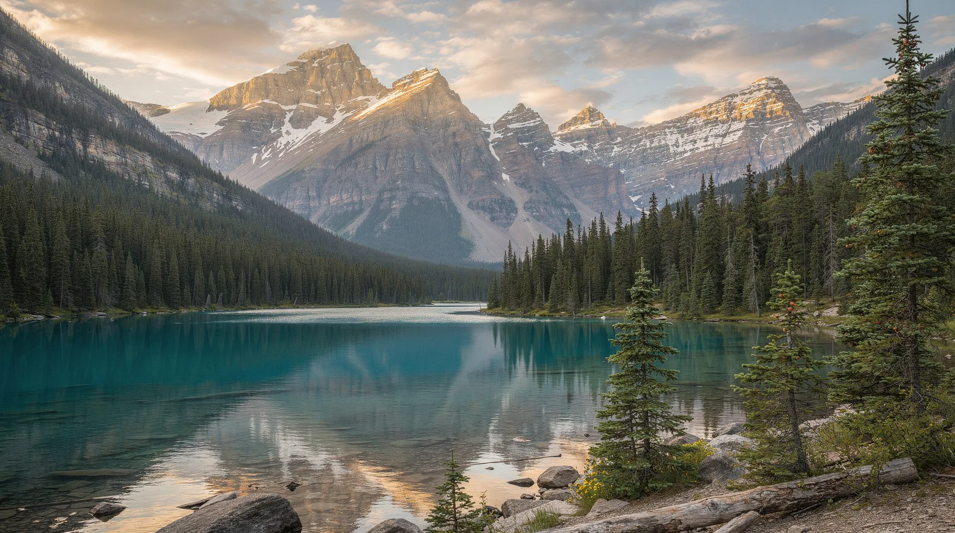
There is a particular moment at the Bow Summit viewpoint when a gap in the spruce trees reveals the lake below — a vivid turquoise shape, wolf-like in outline, filling the valley floor 400 metres beneath the viewpoint ridge. The colour is not what most photographs prepare you for: deeper, more electric, more implausibly blue-green against the surrounding grey limestone. Peyto Lake is the single most visually dramatic viewpoint on the Icefields Parkway, and arguably the most photographed single view in the Canadian Rockies after Moraine Lake.
The lake is named for Bill Peyto, a Banff guide and park warden who reportedly camped at the lake in the 1890s and whose name now attaches to the lake, a peak, and one of Lake Louise’s best-known cafés. Peyto Lake sits at 1,860 metres; the viewpoint at Bow Summit is at 2,090 metres — the highest point on the Icefields Parkway.
Getting to the viewpoint
By car: Peyto Lake is located at Bow Summit, 40 km north of Lake Louise on the Icefields Parkway (Highway 93 North). The parking area (which fills by mid-morning on peak summer days) is at Bow Summit — the highest point on the parkway. The signed trail to the viewpoint begins at the parking lot.
A Banff National Park pass is required — either a daily permit or the annual Discovery Pass. Purchase before reaching the Bow Summit stop.
Distance from Lake Louise: 40 km, approximately 30-35 minutes on the parkway.
Distance from Banff town: 78 km, approximately 65 minutes.
Distance from Jasper: 190 km, approximately 2 hours.
The viewpoint trail
Distance: 1.2 km one-way to the main viewpoint (2.4 km return)
Elevation gain: 100 m
Time: 20-30 minutes one-way; 45-60 minutes return
Difficulty: Easy-moderate — well-maintained boardwalk and gravel trail with some elevation
The trail from the Bow Summit parking area is boardwalked for the upper section (through a recovering area of dwarf krummholz forest damaged by previous visitor pressure) and becomes a gravel path for the descent to the main viewpoint platform. The platform itself, rebuilt with improved sight lines, provides the classic wolf-head panorama: the lake’s outline, the surrounding valley, the Caldron Peak and surrounding mountains above, and the Peyto Glacier visible at the lake’s western end on clear days.
Extended viewpoint (Bow Summit loop): From the main platform, a further 0.8 km of trail continues to a higher viewpoint that provides a different angle on the lake and a wider mountain panorama. This extension is moderately steep and less well-maintained than the main viewpoint trail, but the view from the top is worth the additional 30 minutes.
Photography platform: The main viewpoint has a raised platform designed specifically for photography. Arrive before 8am in summer to have any chance of space on the platform without queuing. By 10am, the platform is typically crowded.
When the colour is best
Peyto Lake’s colour — like all glacially fed Rockies lakes — comes from glacial rock flour suspended in the meltwater that feeds it from the Peyto Glacier above. The colour is most intense when rock flour concentration is highest: late June through mid-July, at peak melt.
Late June to mid-July: Maximum colour intensity. The lake is most electric in this window; photographs from early July regularly show the most vivid blues and greens. The trade-off: early season means the upper trail sections may have residual snow, and the upper extended viewpoint loop may be icy.
August: Still excellent colour, but slightly less vivid than peak melt season. Crowds reach their maximum; parking can be extremely difficult without an early arrival.
September: Colour moderating, but still beautiful. Crowds reduce noticeably after Labour Day. The Bow Summit area in late September may have early snow on the peaks; the larch trees at lower elevations begin turning gold.
May and early June: The Bow Summit area at 2,090 metres retains snow well into June. The lake may still be partially ice-covered in early June. The parkway is open but Bow Summit conditions require winter footwear for the trail.
Early morning vs. midday
Early morning (6-8am): The parking lot has available spaces. The viewpoint is quiet or empty. The lake below may be in shade as the sun rises behind the peaks to the east, but the upper peaks catch the first light and glow. Calm air means the lake surface is still.
Midday (10am-2pm): The parking lot is full or overflowing. The viewpoint is packed. The lake is in direct sun — good for colour saturation but harsh for photography. The crowds at the main platform make tripod photography impractical.
Late afternoon (4-6pm): Crowds reduce as day visitors move on. Light is warming. Longer shadows begin to create texture in the mountain terrain.
The practical answer is simple: arrive before 8am or after 4pm if at all possible.
Browse Icefields Parkway and Banff guided sightseeing toursPhotography guide
Wide angle (14-24mm equivalent): The classic panorama from the main platform. Captures the full lake outline, the surrounding valley walls, and the sky. Use a polarising filter to reduce water surface glare and deepen the turquoise.
Mid-range zoom (35-85mm): Isolating the lake’s wolf-head outline from the surrounding landscape; removing the sky to focus on colour and form.
Telephoto (100-200mm): The Peyto Glacier at the lake’s western end is visible from the extended upper viewpoint on clear days. A telephoto lens allows pulling the glacier into the frame with the lake below.
Composition notes: The most memorable Peyto Lake photographs include foreground interest — the krummholz forest, wildflowers in July, or rocky terrain — to provide depth. Pure lake-only compositions (without foreground) can look flat. The elevated viewpoint and the lake’s wolf-head outline are so distinctive that the image reads well in almost any composition, but foreground elements elevate it.
What else is at Bow Summit
Bow Lake: 6 km south of Bow Summit on the parkway, Bow Lake is a large glacial lake at the base of the Crowfoot Glacier — the source of the Bow River, which flows through Banff and Calgary before joining the South Saskatchewan River. Num-Ti-Jah Lodge (a historic backcountry lodge, now open to day visitors) sits on the north shore. A short lakeshore walk provides views of the Crowfoot Glacier above. Worth a 30-minute stop on the way to or from Peyto Lake.
Bow Summit alpine terrain: The area immediately around Bow Summit supports high-altitude plant communities visible from the trail — alpine flowers, cushion plants, and wind-pruned shrubs at the upper elevation limit of plant growth. Wildflower displays in July at the summit elevation are excellent.
Combining Peyto Lake with the Icefields Parkway
Peyto Lake is best combined with other Icefields Parkway stops as part of a full-day or multi-day drive:
From Lake Louise (south to north): Bow Lake (6 km south of Bow Summit) → Peyto Lake viewpoint → Saskatchewan River Crossing (simple services) → Columbia Icefield and Athabasca Glacier (further 77 km north) → Jasper (further 103 km)
The full parkway drive (Lake Louise to Jasper, 230 km) takes a full day with stops. Most visitors who do the full drive spend at least two days with an overnight at the Columbia Icefield area or in Jasper.
Practical information
Parking: The Bow Summit parking area has limited capacity. Summer peak season (July-August) sees the lot fill by 9-10am. No overflow system exists — if full, you may need to wait for a space to open. Arrive early.
Facilities: No washrooms or food at Bow Summit. The nearest facilities are at Saskatchewan River Crossing (77 km north) or Lake Louise (40 km south). Use the Discovery Centre washrooms at the Columbia Icefield or the facilities at the Lake Louise area before heading to Bow Summit.
Weather: Bow Summit is the highest point on the Icefields Parkway. Weather changes faster here than at lower elevations; afternoon thunderstorms are common in summer. Bring waterproof layers and check the forecast before leaving.
Wildlife: Bow Summit and the surrounding terrain are in active wolf and grizzly territory. Parking lot visits from wildlife (including wolves) have been recorded. Standard Banff precautions apply.