Public transport in Canadian cities
Is public transport good in Canadian cities?
Vancouver and Montreal have excellent public transit. Toronto's system is functional but congested. Smaller cities are more car-dependent. All major cities have transit apps and contactless payment — getting around without a car is very practical in the big three.
Canadian cities are significantly more transit-friendly than their car-centric reputation suggests. Vancouver’s SkyTrain is one of the most efficient urban rail systems in North America. Montreal’s metro is fast, cheap, and well-designed. Toronto’s TTC serves the largest transit network in Canada and is supplemented by commuter rail, streetcars, and an expanding subway.
For visitors, understanding how each city’s transit system works — which cards to get, how to pay, which lines to take — makes getting around much easier and significantly cheaper than relying on taxis or ride-sharing.
Vancouver: the SkyTrain and TransLink network
Vancouver’s transit system, operated by TransLink, is widely regarded as the best in Canada. The SkyTrain automated rail network runs across three lines:
Expo Line: Main east-west spine through downtown, Commercial Drive, Surrey, and Langley.
Millennium Line: Parallel east-west line extending to Coquitlam.
Canada Line: Connects downtown Vancouver to Richmond, YVR airport, and Bridgeport.
The Canada Line is the main airport connection — it runs from Vancouver International Airport (YVR) to downtown Waterfront station in 26 minutes for approximately CAD $9–11 (fare includes the airport surcharge on the first leg).
Getting around Vancouver by transit
- Compass Card: The reloadable tap card for the TransLink system. Available at SkyTrain stations, London Drugs, and online. CAD $6 deposit, refundable when returned. Significantly cheaper than single fares — buy one on arrival.
- DayPass: CAD $11.50 for unlimited transit access on buses, SkyTrain, and SeaBus for one day. Worth it for 4+ trips.
- SeaBus: The ferry between downtown Vancouver (Waterfront) and North Vancouver (Lonsdale Quay). Runs every 15–30 minutes, takes 12 minutes, included in the transit fare. One of the most pleasant ways to see the downtown skyline.
- Buses: TransLink’s bus network fills gaps the SkyTrain doesn’t cover. Same Compass Card tap-on system.
For getting to Whistler from Vancouver, the Whistler Mountaineer bus service or a tour is the practical option — the SkyTrain doesn’t reach there. See our RV and camper van guide for the Sea-to-Sky Highway driving alternative.
Full-day Whistler tour from Vancouver — includes transport, guide, and activitiesTransit tips for Vancouver
- Bikes are allowed on SkyTrain except during peak hours (7–9am and 3–5:30pm outbound)
- Night bus services run after SkyTrain hours (from approximately midnight)
- Granville Island is reached by a False Creek ferry (not TransLink) — a small private ferry from multiple downtown docks
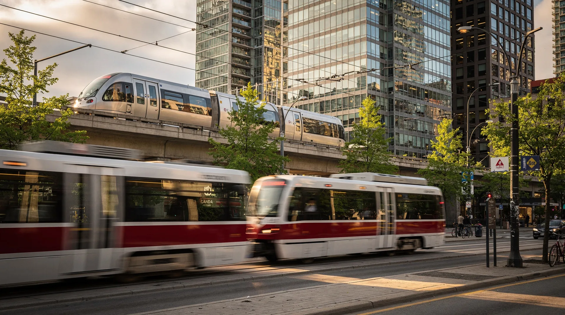
Toronto: the TTC, GO Transit, and UP Express
Toronto’s transit is more complex than Vancouver’s due to the city’s size and the multi-layered network of operators.
TTC (Toronto Transit Commission)
The main city transit authority operating:
- Subway: Four lines, with the Bloor-Danforth (Line 2) and Yonge-University (Line 1) being the main commuter arteries. Clean, frequent, and reliable.
- Streetcars: Toronto is one of the last North American cities with a substantial streetcar network. Routes along King Street, Queen Street, Spadina, and Bathurst are heavily used. More scenic than buses but slower due to traffic.
- Buses: Extensive network covering the entire city.
Fares: Single TTC fare is CAD $3.30 as of 2026 (exact change on buses; Presto card available at subway stations). Transfers are free within 2 hours of the initial tap.
Presto Card: Toronto’s tap card. Load credit at subway station machines or online. The standard way to pay for TTC, GO Transit, and most other transit in the Greater Toronto Area.
GO Transit
Provincial commuter rail and bus system covering the Greater Toronto and Hamilton Area. Connects Union Station in downtown Toronto to suburbs and outlying cities including Hamilton, Burlington, Oakville, Brampton, and Barrie. Relevant for visitors staying outside downtown or day-tripping.
UP Express
Dedicated rail service between Toronto Pearson Airport (YYZ) and Union Station downtown. Takes 25 minutes, runs every 15 minutes, costs CAD $12.35 from the airport, and accepts Presto cards. The standard and recommended way to get between Pearson and downtown Toronto.
Transit tips for Toronto
- Rush hour on the Bloor-Danforth line (particularly the stretch between Bloor-Yonge and Spadina) is crowded and slow — avoid peak hours (7:30–9am and 4:30–6:30pm) if possible
- King Street is car-restricted through the entertainment district — streetcars are significantly faster here than Uber or taxi
- The PATH (underground pedestrian network) links Union Station to most major downtown buildings — useful in winter
Montreal: the STM Metro
Montreal’s metro is a classic — smooth-riding rubber-tyred trains, architecturally distinct stations (each designed by a different architect), and comprehensive coverage of the island. It’s fast, clean, and one of the easiest systems for visitors to understand.
Metro lines
- Green Line (Ligne verte): East-west through downtown and Plateau; the main tourist line
- Orange Line (Ligne orange): North-south, connecting Côte-Vertu to Longueuil; passes through the busy Lionel-Groulx interchange
- Blue Line (Ligne bleue): East-west in the north of the island
- Yellow Line (Ligne jaune): Short line to Longueuil and the Olympic Stadium area
Getting around Montreal by transit
- Opus Card: Montreal’s reloadable transit card, available at metro station machines (CAD $6 deposit). Tap to enter stations — no tickets needed once loaded.
- Day passes and multi-day passes: CAD $11 for a 1-day pass, CAD $20.75 for 3 days. Worth it for active visitors.
- Buses: The STM bus network complements the metro extensively. The same Opus Card works on both.
Transit tips for Montreal
- The metro operates from approximately 5:30am to 1am daily (to 2:30am on Fridays and Saturdays)
- The Bixi bike-sharing system is excellent in Montreal — CAD $3.25 for a single 45-minute ride or CAD $17/week for unlimited short trips
- Accessing the Old Port and Old Montreal from downtown is easy by metro (Square-Victoria–OACI station on the Orange Line, or Champ-de-Mars on the Green Line)
Ottawa: OC Transpo
Ottawa’s transit system has a newer LRT (O-Train Confederation Line) supplementing an extensive bus network. The LRT runs east-west through the city, connecting major destinations including downtown and the University of Ottawa area.
Transit cards: The Presto card is used in Ottawa as well as Toronto — the same card works in both cities, which is useful for multi-city trips.
Ottawa’s main visitor attractions (Parliament Hill, National Museum of Natural History, Canadian Museum of History) are well-connected by transit or within easy walking distance of LRT stations.
Quebec City: RTC
Quebec City is compact enough that most visitor attractions are within walking distance in the Old City (Vieux-Québec). The RTC bus network serves the wider city. Most visitors find a taxi or Uber preferable to the bus network for the limited times they need motorised transport.
The Old City itself — Château Frontenac, the Plains of Abraham, the Upper Town and Lower Town — is best explored on foot. The funicular (cable railway) between Upper and Lower Town is worth taking once for the experience.
Calgary: CTrain
Calgary’s CTrain (light rail) runs on two lines in a cross pattern through the city. Downtown is a fare-free zone, meaning transit within the downtown core is completely free. The CTrain connects to key areas including the Beltline, University of Calgary, and Chinook Centre.
Calgary is more car-oriented than Vancouver or Montreal — most neighbourhoods beyond the downtown core and inner suburbs are best reached by car or ride-sharing. However, the CTrain is sufficient for most visitor needs.
Edmonton: Valley Line and LRT
Edmonton has an expanding LRT network, though coverage is less comprehensive than in Vancouver or Montreal. The Valley Line West opened in 2023 and significantly improved coverage of the south and southeast. The high-level bridge between downtown and the University of Alberta campus is best reached by LRT.
Inter-city transit options
Getting between Canadian cities without flying is often practical and sometimes preferable. See our domestic flights guide for a comparison of flying vs. ground options.
VIA Rail: Canada’s intercity passenger train service. Key routes include the Toronto–Montreal Corridor (4h40m, approximately CAD $40–100 one-way), Toronto–Ottawa (4h, approximately CAD $35–90), and the legendary cross-country Canadian (Toronto–Vancouver, 4 days). See our Via Rail guide.
FlixBus: Now operating on the Toronto–Montreal and Toronto–Ottawa corridors. Significantly cheaper than trains (CAD $25–60 one-way) with comfortable coaches and direct routes. Good Wi-Fi.
Megabus / Coach Canada: Coach bus services particularly strong in Southern Ontario. Toronto to Niagara Falls by coach is a popular option.
BC Ferries: Essential for Vancouver Island access. The main route from Tsawwassen (south of Vancouver) to Swartz Bay (near Victoria) takes 1 hour 35 minutes and runs up to 16 times daily. Reserve vehicles in advance in summer; foot passengers can always board.
Transit apps and planning tools
- Transit App (transitapp.com): The best third-party transit app for Canada. Works in Vancouver, Toronto, Montreal, Ottawa, and Calgary. Real-time arrivals, trip planning, and nearby stops.
- Google Maps: Excellent for transit directions in all major Canadian cities, with real-time arrival data in most systems.
- Moovit: Good alternative, particularly strong in Montreal.
- City-specific apps: TransLink (Vancouver), TTC (Toronto), STM (Montreal) all have official apps with real-time data.
Accessibility
Canadian public transit systems are generally well-equipped for accessibility:
- All SkyTrain stations in Vancouver have elevators
- TTC in Toronto has accessibility features at most subway stations (a few older stations have retrofitting underway)
- Montreal’s metro has elevators at most stations following a multi-year programme
- All cities have low-floor accessible buses
Visitors with mobility needs should check the specific station accessibility status on the transit operator’s website before travelling.
Cycling as urban transport
Canada’s major cities have developed cycling infrastructure significantly in recent years:
Montreal: One of the best cycling cities in North America. The Bixi bike-share network covers most of the island. Protected bike lanes on major streets. Cycling in winter is a Montreal tradition.
Vancouver: The seawall cycling path, the Central Valley Greenway, and the growing network of protected lanes make Vancouver excellent for cycling. Mobi Bikes is the city’s bike-share system.
Toronto: Improving rapidly but more car-oriented than Montreal or Vancouver. The Bike Share Toronto network has docking stations across the downtown core.
Recommendations by traveller type
City-focused travellers: Transit is the way to go in Vancouver, Montreal, and Toronto. Buy the city’s transit card on day one, load enough credit for the trip, and save money vs. taxis. Uber and Lyft are available in all Canadian cities but are significantly more expensive.
Budget travellers: Transit + walking covers almost everything in major Canadian cities. The Bixi or Mobi bike-share systems add another option for free or very low cost.
Families: Strollers and pushchairs are allowed on all transit. Children under a certain age (varies by city — typically 12 or under) travel free or at reduced fare. Check the city’s transit authority for current rules.
RV and road trippers: Use transit for city exploration while your vehicle is parked — parking in downtown Vancouver, Toronto, and Montreal is expensive (CAD $30–50/day). Transit to the city centre from a suburban parking area is the efficient strategy.
Frequently asked questions about Public transport in Canadian cities
Do I need a transit card or can I pay by contactless bank card?
Most Canadian transit systems now accept contactless Visa and Mastercard directly — you can tap your bank card or phone (Apple Pay, Google Pay) at fare gates in Vancouver, Toronto, and Montreal. However, the local transit card (Compass, Presto, Opus) is often slightly cheaper per trip. For short visits, contactless bank card works fine.
How late does public transit run in Canadian cities?
Most subway and LRT systems operate until midnight–1am on weekdays and slightly later on weekends. Night bus services cover key routes after rail services stop. Service frequency drops significantly after 11pm.
Is Uber available in Canadian cities?
Yes — Uber and Lyft operate in all major Canadian cities. Prices are comparable to other North American cities (CAD $15–30 for typical city trips). Surge pricing applies during peak hours, late nights, and events. Transit is almost always cheaper.
Can I take a bicycle on the metro?
In Vancouver, bikes are permitted on SkyTrain outside peak hours. In Montreal, bikes are permitted on the metro on weekdays outside rush hour and all day on weekends. In Toronto, bikes are permitted on the subway outside peak hours. Rules change; check the current policy on each system’s website.
What is the best transit app for Canada?
Transit App is the most comprehensive option that works across multiple Canadian cities. Google Maps provides reliable transit directions in all major cities and is often the easiest starting point.
Is Toronto easy to get around by transit?
Toronto is manageable by transit but the system is more complicated than Vancouver or Montreal, and the city is larger. The subway and streetcar network covers the inner city well. Outer suburbs and some neighbourhoods are better served by bus or GO Transit. For most tourist purposes — downtown, entertainment district, Harbourfront, museums — the TTC is entirely sufficient.
How do I get from downtown Montreal to the airport?
Bus line 747 operates 24 hours between Pierre Elliott Trudeau International Airport (YUL) and downtown Montreal (Berri-UQAM metro station). Takes approximately 45–70 minutes depending on traffic. Cost is CAD $11 (Opus Card) or CAD $10 cash. A taxi costs CAD $55–65 flat rate to downtown.