Ha Ling Peak hike: Canmore's iconic summit
How hard is the Ha Ling Peak hike?
Ha Ling Peak is strenuous: 6 km return with 730 m elevation gain from the Goat Creek parking area. The trail is relentlessly steep. Most hikers complete the round trip in 3–4 hours. The summit delivers a 360-degree view of the Bow Valley and the Three Sisters massif.
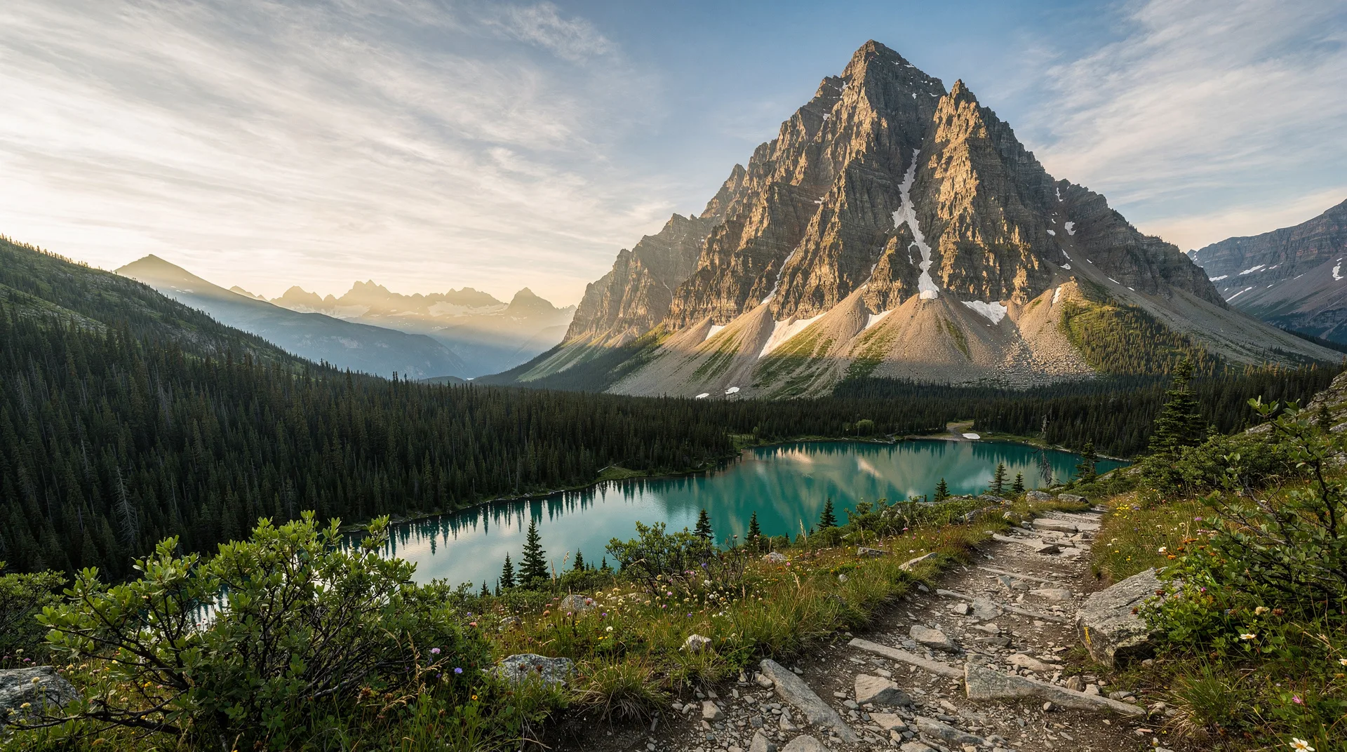
Ha Ling Peak is the defining hike of Canmore. The summit — at 2,407 metres above the Bow Valley — is visible from the town below as a distinctive pointed peak to the south, and reaching it is something of a local rite of passage. The trail is short by Rocky Mountain standards but exceptionally steep: 730 metres of elevation gain in just 3 kilometres one way makes this one of the most efficient altitude-gain hikes in Alberta.
The view from the summit is the payoff. The Bow Valley stretches east toward Calgary and west toward Banff; the Three Sisters massif fills the southwest horizon; the Rundle range lines the north; and on clear days the skyline of peaks extends to every horizon with identification only possible with a map. For visitors staying in Canmore, Ha Ling is the hike that introduces the scale and character of the Canadian Rockies better than any other.
The peak is named after Ha Ling, a Chinese cook at the nearby silver mine in Canmore who climbed the summit in 1896 on a bet — completing the ascent in half the time his colleagues predicted was possible. It was briefly renamed Chinaman’s Peak in 1896 (from a historical derogatory term) and officially renamed Ha Ling Peak in 1997.
Trail overview
Trailhead: Goat Creek parking area (also signed as Ha Ling Peak / Goat Creek trailhead), east of Canmore on Spray Lakes Road Distance: 6 km return Elevation gain: 730 m Difficulty: Strenuous Duration: 3–4 hours return Trail surface: Well-maintained steep trail; rocky and loose on upper sections; scree near summit Dogs: Permitted on leash
The trail begins at the parking area and immediately gains elevation through subalpine forest on a series of steep switchbacks. This is the character of Ha Ling: there is no gradual approach, no warm-up section. The gradient demands cardiovascular effort from the first 200 metres.
At approximately 2 km, the trail breaks above treeline and the views open. The last kilometre to the summit crosses open scree and rocky terrain — the gradient eases slightly but the footing requires attention.
The true summit is marked by a cairn. A false summit visible below the true peak misleads many first-time visitors into premature celebrations — the real top is approximately 100 metres further and 30 metres higher.
The summit experience
The 360-degree view from Ha Ling’s summit is one of the finest accessible from a half-day hike in the Canadian Rockies.
East: The Bow Valley opens to the prairie, with Canmore town visible below and the cityscape of Calgary faintly visible on very clear days, 100 km distant.
West: The Bow Valley continues toward Banff, with the Banff townsite area visible in the valley floor and the peaks above the Banff ski resorts clear on the horizon.
Southwest: The Three Sisters — Faith, Hope, and Charity — fill the horizon at close range. The summit of Ha Ling sits at a similar elevation to the upper shoulders of the Three Sisters, making the relationship between the peaks viscerally apparent.
North: The Rundle Range, a continuous serrated wall of dipping limestone, dominates the northern horizon. Mount Rundle’s distinctive inclined strata — the layers dip at approximately 60 degrees — are clearly visible.
Summit conditions: The summit is exposed and windy. Even on a warm valley day, temperatures at 2,407 m with wind can feel cold. Always bring a warm layer for the summit stop.
Practical information
Getting to the trailhead
The Goat Creek / Ha Ling trailhead is approximately 5 minutes by car from Canmore’s main street:
- From central Canmore, head south on Spray Avenue
- Continue past the Nordic Centre onto Spray Lakes Road
- The parking area is on the left, well-signed, approximately 2 km past the Nordic Centre turnoff
The parking area is free and relatively large, but fills by 8–9 am on summer weekends. There is no shuttle service; all visitors arrive by private vehicle, bicycle, or on foot from Canmore.
On foot from Canmore: It is possible to walk from Canmore to the trailhead (approximately 3.5 km additional each way on Spray Lakes Road) but adds significantly to an already strenuous day. Most people drive.
Parks Canada note
Ha Ling Peak is within Alberta’s provincial jurisdiction — it is NOT in Banff National Park. No Parks Canada Discovery Pass is required for the Ha Ling Peak trail. This makes it an excellent option for visitors who want to avoid park entry fees. Canmore itself is outside the national park.
Best time to hike
June through October: The primary season. The trail is typically snow-free from mid-June through early October, though conditions vary by year.
July and August: Peak summer. Warm, generally settled weather. The trail is busy on weekends; start before 7 am to have the summit relatively quiet. Afternoon thunderstorms can develop by 2–3 pm.
September and early October: The optimal window for many experienced hikers. Smaller crowds, clearer air, autumn colours beginning in the valley below, and the possibility of fresh snow on surrounding peaks for dramatic summit photography. The larch forests of nearby Grassi Lakes and the Canmore area begin their colour change.
Spring (May–June): Snow and ice on the upper sections make microspikes or crampons necessary in May and early June. The lower trail may be muddy. Inexperienced hikers should wait for clear trail conditions.
November through May: Variable snow and ice conditions. The trail is not maintained in winter. Snowshoes or microspikes are typically required. The summit is achievable in winter for experienced winter hikers but the conditions can be genuinely serious.
What to bring
- Sturdy hiking boots (the rocky, loose upper section needs ankle support)
- Trekking poles (strongly recommended; the descent on steep, loose terrain is significantly safer with poles)
- Wind and insulating layer for the summit (mandatory even in summer)
- Rain jacket
- 2 litres of water (no water sources on the trail)
- Snacks
- Bear spray (black bears are common in the Canmore area; grizzlies are less common but present)
- Sunscreen (intense UV above treeline)
- Camera (the summit view justifies it)
Trail safety
The descent: The upper section of Ha Ling, particularly the scree below the summit, is slippery and loose. Many ankle injuries on Ha Ling occur on the descent, not the ascent. Trekking poles, slow controlled steps, and wearing boots rather than trail runners all reduce risk significantly.
Afternoon lightning: Ha Ling’s open summit is highly exposed. The Bow Valley is prone to afternoon thunderstorms from June through August. The summit is not a safe place to be when lightning is in the area — the highest point in the immediate landscape is not where you want to be. Start early enough to be off the summit before noon or 1 pm.
False summit trap: The trail appears to end at a wide rocky area below the true summit. A further rocky scramble of 10–15 minutes reaches the real top. Continue beyond the apparent summit unless weather or energy dictates otherwise.
Crowds and trail erosion: Ha Ling is one of the most hiked trails in the Bow Valley and trail erosion is a documented concern. Stay on the marked trail at all times, particularly on the upper section. Cutting switchbacks damages vegetation and accelerates erosion.
Combining with other Canmore hikes
Ha Ling is the most famous of several excellent hikes immediately accessible from Canmore:
- Grassi Lakes hike — an easier alternative starting from the same Spray Lakes Road corridor; suitable for families and beginner hikers
- Cross-country skiing in Canada — the Canmore Nordic Centre, visible from the Ha Ling trailhead approach, is Canada’s premier Nordic skiing facility
- Banff National Park guide — Banff is 25 km west of Canmore; combine Ha Ling with a Banff visit easily
- Banff Upper Hot Springs — a post-hike soak 25 minutes away in Banff
Canmore as a base
Canmore is an excellent and often underestimated base for Rockies hiking. Located just outside the national park boundary, accommodation prices are generally lower than in Banff, parking in town is free and abundant, and the range of restaurants and services rivals Banff townsite. The drive to Banff National Park from Canmore (25 km on the Trans-Canada) takes under 30 minutes.
For Canmore visitors, Ha Ling Peak and Grassi Lakes are walkable or driveable in minutes, and the full range of Lake Louise and Banff trails are within 45–75 minutes by car.
Frequently asked questions about Ha Ling Peak hike: Canmore’s iconic summit
Is Ha Ling Peak harder than Banff’s hikes?
Ha Ling is steeper per kilometre than most of the standard Banff teahouse hikes (Lake Agnes, Plain of Six Glaciers) but covers less total distance. It is comparable in overall effort to the Lake Agnes trail and somewhat less total effort than the Plain of Six Glaciers, but feels harder because the gradient is more relentless. Hikers who have done either of the Lake Louise teahouse trails will be in appropriate physical condition for Ha Ling.
Can I combine Ha Ling Peak and Grassi Lakes in one day?
Yes — both trailheads are on Spray Lakes Road within 2 km of each other, and both trails can be done in a single day for hikers with good fitness. Start with Ha Ling early (the harder, more committing hike) and do Grassi Lakes afterward (shorter, lower difficulty). Total hiking time for both is approximately 5–6 hours.
Is Ha Ling suitable for beginner hikers?
Ha Ling is classified as strenuous and is not recommended as a first Rocky Mountain hike. Beginners who want a Canmore trail should start with Grassi Lakes (see our Grassi Lakes guide). Ha Ling is best attempted once you have a few moderate hikes (1,000 m total or more) in your legs.
What shoes do I need for Ha Ling?
Trail runners are fine for experienced hikers who are confident on loose terrain. Waterproof hiking boots with ankle support are the safer and more comfortable choice for most visitors. Do not attempt Ha Ling in sneakers, sandals, or casual footwear — the loose upper section makes grip and ankle stability important.