Grassi Lakes hike: easy beauty near Canmore
How hard is the Grassi Lakes hike?
Grassi Lakes has two route options: an easy, wide path (3.6 km return, 200 m gain) and a more scenic, steeper route (same distance but with a waterfall). Both take 1.5–2.5 hours return. The trail is accessible to most ages and fitness levels, making it one of the best beginner hikes in the Canmore area.
Not every great hike in the Canadian Rockies requires a full day, a permit system, or strenuous fitness. Grassi Lakes near Canmore proves the point: a short trail leads to two turquoise alpine lakes set against a limestone cliff face, with the optional discovery of ancient Indigenous rock art and a canyon waterfall en route. The whole experience can be completed in under 3 hours, and the quality of the destination — the vivid colour of the water, the rock walls above, the stillness of the lakes — is genuinely impressive by any standard.
Grassi Lakes is the ideal introduction to Rockies hiking for families, beginners, and visitors who want beautiful scenery without committing to a strenuous full-day trail. It is also an excellent warm-up hike for those building toward more demanding objectives like Ha Ling Peak or the Banff teahouse trails.
Trail overview
Trailhead: Grassi Lakes parking area, accessed via Spray Lakes Road from Canmore Distance: 3.6 km return (both routes) Elevation gain: 200 m (easy route) / approximately 220 m (harder route) Difficulty: Easy to easy-moderate Duration: 1.5–2.5 hours return Trail surface: Well-maintained gravel path on easy route; rocky and steeper on the harder route Dogs: Permitted on leash
The Grassi Lakes trail offers two parallel routes to the lakes — hikers choose at the trailhead:
Easy route (lower path): A wide, well-graded path suitable for children, older adults, and anyone who wants a relaxed approach. The gradient is steady but not steep. This path is the standard recommendation for families with young children.
Harder route (waterfall path): Branches left from the trailhead and follows Grassi Creek through a small canyon before climbing more steeply past a waterfall to the lakes. Slightly shorter in actual distance but more demanding and more scenic. Rocky scrambling sections near the waterfall require sure footing. This route is significantly more rewarding visually and is the choice of most hikers with any prior hiking experience.
Both routes arrive at the same destination: the two Grassi Lakes.
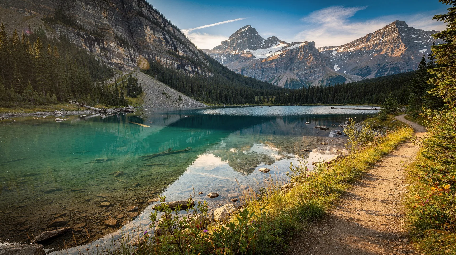
The lakes
The two Grassi Lakes sit in a cirque below the Ha Ling Peak / Grotto Mountain ridge at approximately 1,700 metres elevation. Their colour — a vivid turquoise-green — is produced by glacial rock flour suspended in the water, the same phenomenon that colours Lake Louise and Moraine Lake, and the visual effect is similarly striking despite the much smaller scale.
The upper lake is larger and the more photographed; the lower lake sits slightly below and offers a view of the upper lake and the cliff face behind it. Between and around the lakes, the setting is quiet — sheltered by the surrounding rock faces, shaded in morning, and removed from the road noise below.
Swimming: Swimming in Grassi Lakes is technically possible (the water is cold) and was common in previous decades. Parks Alberta has progressively discouraged swimming to protect the delicate ecosystem. Check current regulations and follow posted signs.
Rock art: On the cliff face beside the lower lake, pictographs (rock paintings) created by Indigenous people several thousand years ago are preserved on the limestone surface. The images are faint — red ochre designs that include animal figures and geometric patterns. Signs at the site explain their significance. Do not touch or approach the rock art surface.
The waterfall (harder route)
The harder route to Grassi Lakes passes through a narrow canyon section and climbs beside a two-tiered waterfall on Grassi Creek. The waterfall is the scenic highlight of the approach and is most impressive in late May and June during peak snowmelt. By late summer the flow diminishes but the canyon setting remains dramatic.
A short scramble on rocky steps beside the upper waterfall requires hands on wet rock in high-water conditions — take care here, particularly with children. The rock is slippery when wet.
Practical information
Getting to the trailhead
The Grassi Lakes parking area is on Spray Lakes Road, approximately 3.5 km from central Canmore:
- From Canmore’s main street, head south on 8th Avenue / Spray Avenue
- Continue past Canmore Nordic Centre onto Spray Lakes Road
- The Grassi Lakes parking area is signed on the left, approximately 1.5 km past the Nordic Centre turnoff
Parking is free. The lot is smaller than Ha Ling’s and can fill on busy summer weekends. Arrive before 8 am on summer weekends or park lower and walk.
No Parks Canada pass required: Grassi Lakes is within Kananaskis Country / provincial jurisdiction, not Banff National Park. No park entry fee applies.
On foot from Canmore: The trailhead is walkable from central Canmore — approximately 35–40 minutes on foot each way via Spray Avenue and Spray Lakes Road. This is a reasonable option for Canmore-based visitors and eliminates the parking issue.
Best time to hike
May through October: The trail is accessible most of the year. May and early June offer the most dramatic waterfall (high snowmelt flow) and smallest crowds.
June through August: Peak season. Busy on weekends; early morning visits (before 8 am) significantly improve the experience. The lakes are at their most vivid in full summer sun.
September: Excellent conditions. The autumn light is flattering for the turquoise colour of the lakes. Smaller crowds than summer. The Canmore larch areas (nearby but not on this trail) are turning in late September.
Winter: The trail is accessible via microspikes or snowshoes in winter. The waterfall route freezes and creates ice formations that are beautiful but require careful navigation. The easy route is more manageable in winter conditions. Check current conditions before visiting in winter.
What to bring
- Comfortable hiking shoes or trail runners (proper hiking boots not required for the easy route, but recommended for the waterfall route)
- Water (no water sources on the trail; bring 1 litre per person for a 2-hour hike)
- Snacks
- Layers (the cirque at the lakes is cooler than the valley)
- Rain jacket (afternoon rain is possible)
- Bear spray (black bears are present in the Canmore area)
- Camera
Wildlife and ecology
The Grassi Lakes area is part of the Bow Valley Wildlife Corridor, a critical movement zone for large mammals between the Banff/Kananaskis regions. Wildlife sightings near the trail are not uncommon:
Black bears: The Bow Valley around Canmore has an active black bear population. Bear spray should be carried on all hikes in this area. Black bear sightings are documented near the Grassi Lakes trailhead, particularly in berry season (August–October).
Bighorn sheep: The rocky terrain above the lakes is excellent bighorn habitat. Rams are frequently seen on the cliff faces above the upper lake and sometimes at the lake shore itself. Maintain distance and do not feed them.
Pikas: The boulder fields near the lakes host pikas — listen for their sharp, high-pitched call.
Rock art site ecology: The pictograph site near the lower lake is an archaeologically sensitive site. Trampling of the surrounding area and touching the rock face causes irreversible damage. Stay on the designated path and observe from the viewing distance.
Safety
Waterfall route scramble: The rocky sections beside the upper waterfall require care, particularly when wet. Supervise children closely; the rock can be genuinely slippery in spring and after rain.
Cliff edge at lakes: The upper lake has a cliff edge on the far side. Stay on the trail and keep children away from the cliff edge.
Dogs near bighorn sheep: Dogs can cause significant stress to bighorn sheep that frequent the lake area. Keep dogs leashed at all times and steer clear if sheep are present near the trail.
Canmore as a base for day hiking
Grassi Lakes is one of several excellent trails within minutes of Canmore that require no Parks Canada pass. Other Canmore-area highlights:
- Ha Ling Peak — the strenuous summit hike for those ready to step up from Grassi Lakes
- Banff National Park guide — 25 minutes from Canmore, with full access to Banff’s trail network including the teahouse hikes
- Lake Louise hikes overview — 45 minutes from Canmore; the Plain of Six Glaciers and Lake Agnes trails
- Johnston Canyon hike — one of Banff’s most distinctive canyon experiences, 40 minutes from Canmore
- Cross-country skiing in Canada — the Canmore Nordic Centre, adjacent to the Grassi Lakes trailhead, is the premier Nordic skiing facility in Canada
Frequently asked questions about Grassi Lakes hike: easy beauty near Canmore
Is Grassi Lakes suitable for toddlers?
The easy route is one of the most stroller-and-toddler-friendly hikes in the Canmore area. The path is wide and graded, the distance is short, and the turquoise lakes at the end are genuinely exciting for children. Small children in carriers easily manage the trail with adult assistance. The waterfall route is not stroller-accessible.
How does Grassi Lakes compare to Lake Louise?
Both have vividly coloured turquoise water produced by glacial rock flour. Lake Louise is dramatically larger, the setting is more dramatic (glacier-capped peaks), and the Chateau hotel adds a distinctive character. Grassi Lakes is quieter, no park entry fee applies, and the access trail has the waterfall bonus. Both are worth visiting; Grassi Lakes is the better choice for visitors prioritising accessibility and simplicity.
Can I swim at Grassi Lakes?
Swimming has been historically popular but is increasingly discouraged by Parks Alberta due to the sensitivity of the ecosystem. Check posted signage at the lake for current rules. Water temperature is cold year-round (glacial snowmelt fed).
Is the waterfall route worth the extra effort?
Yes, for any hiker comfortable on rocky terrain. The waterfall is the most scenic feature of the entire trail and the canyon section provides a sense of discovery that the easy route lacks. The additional difficulty is modest — if you can handle the easy route, the waterfall route is manageable with appropriate footwear.