Cape Breton Highlands National Park: the Cabot Trail and Nova Scotia's wild north
What makes Cape Breton Highlands National Park special?
Cape Breton Highlands protects a vast plateau of boreal forest and river canyons above dramatic coastal cliffs in northern Cape Breton. The Cabot Trail — a 298-km coastal highway that loops through the park — is one of the world's great scenic drives, combining highland scenery with Celtic and Acadian culture.
Cape Breton Highlands National Park is the centrepiece of what many consider Canada’s most dramatically beautiful road trip. The park sits at the northern tip of Cape Breton Island, protecting 948 km2 of highland plateau, ancient river gorges, and the cliffs and coves where the Highlands meet the Atlantic Ocean and the Gulf of St. Lawrence. The Cabot Trail — a 298-km loop highway that circles through and around the park — is the vehicle for experiencing it all.
The landscape is more complex than a single description can contain. The plateau itself is a remnant of ancient Appalachian terrain, flat in places and deeply cut by river valleys called “intervales” that descend from the highlands to the coast. The western coastline, facing the Gulf of St. Lawrence, drops in long, spectacular sweeping curves from the high road to small fishing communities at the water’s edge. The eastern side is more rugged, with headlands and coves along the Atlantic.
The communities around the park carry cultural layers that make Cape Breton as interesting socially as it is visually: Acadian French fishing villages on the west coast where French-language culture has survived since the 18th century, Mi’kmaw communities with 10,000 years of continuous presence on this land, and the Scottish Gaelic heritage that arrived with the Highland clearances in the 18th and 19th centuries and produced a fiddle and step-dancing tradition that continues to this day. Cape Breton is genuinely one of the last places on earth where you can hear Scottish Gaelic spoken as a living community language.
Getting to Cape Breton Highlands
Cape Breton Island is connected to the Nova Scotia mainland by the Canso Causeway — a causeway across the Strait of Canso, about 3.5 hours from Halifax by car. The park entrance at Cheticamp (west side) is about 90 minutes north of the Canso Causeway; the Ingonish entrance (east side) is about 2 hours. Both are well-signed from the Trans-Canada Highway (Highway 105) that runs up the centre of Cape Breton.
Most visitors drive the Cabot Trail as a loop from the town of Baddeck (on the Bras d’Or Lake, about 1 hour from the causeway) — a sensible base with good accommodation and the excellent Alexander Graham Bell National Historic Site. There is no scheduled air service to Cape Breton with connections to the park area; Sydney airport (1.5 hours from Ingonish) serves Halifax and Toronto.
Browse Cape Breton Island tours and Cabot Trail experiencesThe Cabot Trail: driving the loop
The Cabot Trail is named after John Cabot, the Italian-born explorer who made landfall on Cape Breton in 1497 on behalf of the English Crown. The highway was completed in 1932 and remains one of the finest examples of scenic road design in Canada — the engineers who built it understood that the route itself was the destination.
Clockwise versus counter-clockwise: Most guides recommend driving clockwise — starting from Baddeck, turning north to Cheticamp, up the west coast and over the Highlands, then down the east coast through Ingonish and back south to Baddeck. This keeps the cliff edge on the driver’s side on the most dramatic sections, which is both safer and more rewarding visually.
How long does it take: The loop can theoretically be driven in a long day (6-7 hours without stops), but doing it properly requires 2-3 days with overnight stops on the trail. The Cheticamp side and the Ingonish side both deserve afternoon and evening time, and the park interior is best explored on foot at multiple stops.
Cheticamp: the Acadian gateway
Cheticamp is the largest community on the west side of Cape Breton and the heart of the island’s Acadian community — French-speaking, Catholic, and maintaining cultural traditions that arrive here in the early 18th century. The harbour with its colourful boats, the Church of Saint-Pierre dominating the skyline, and the smell of the sea and fish processing plants give Cheticamp a working authenticity that many tourist towns lack.
The Les Trois Pignons cultural centre contains the remarkable collection of hooking rugs created by Elizabeth LeFort — monumental tapestries worked in the traditional Acadian rug-hooking style that depict religious, historical, and natural scenes with extraordinary detail and skill. The collection includes a 45-panel portrait of Pope John XXIII that was exhibited at the Vatican. The craft tradition she helped revive is still actively practiced in Cheticamp.
For food, Cheticamp is the place to eat Acadian cuisine. Rappie pie (rapure) — a grated potato and chicken or clam dish that sounds unusual and tastes excellent — is the traditional Acadian staple. Restaurant Acadian on Main Street is a reliable choice.
The park entrance at Cheticamp has an excellent visitor centre with exhibits on the park’s natural and human history and a Parks Canada team that can advise on current trail conditions, wildlife activity, and weather.
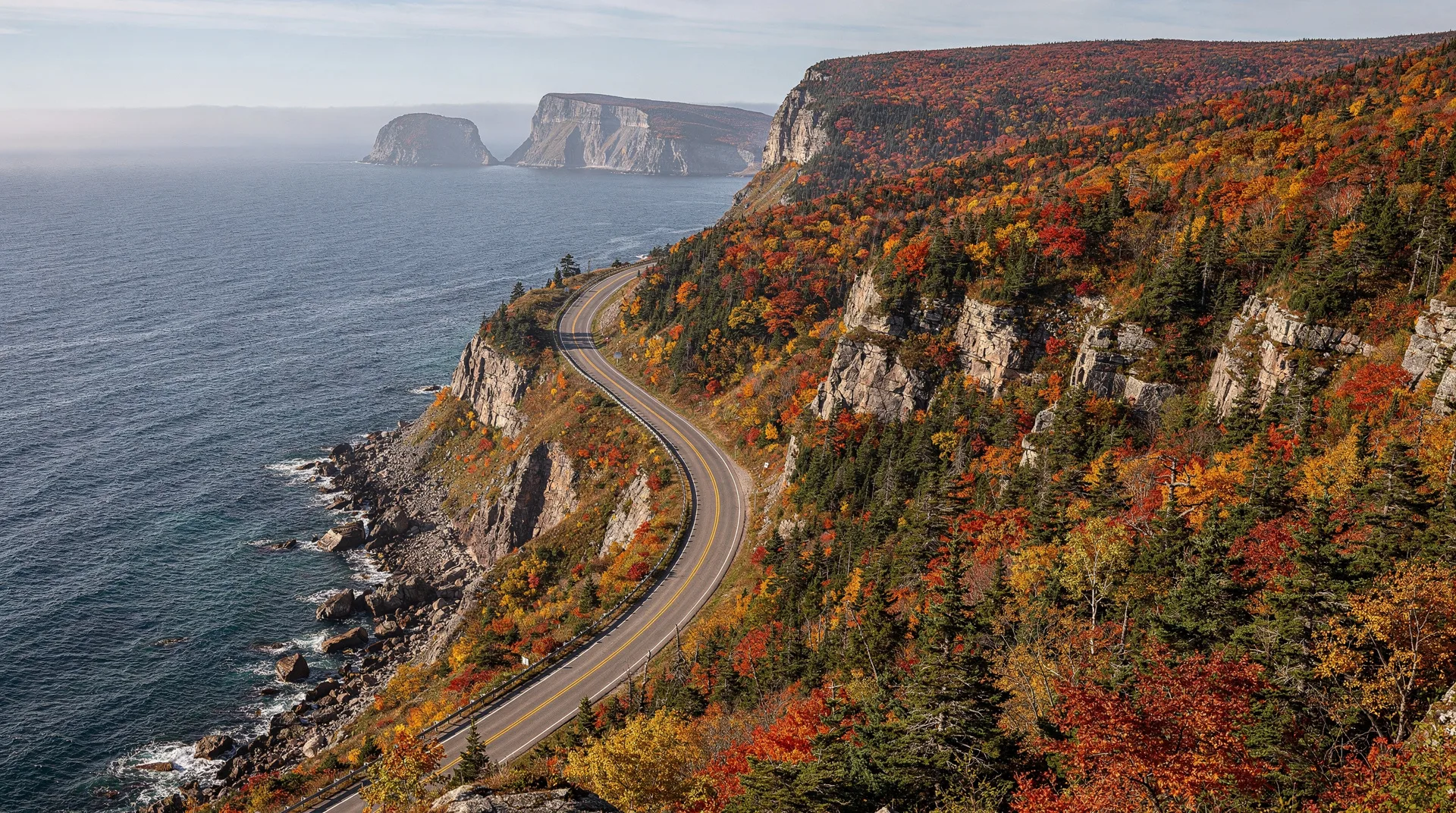
The highland section: French Mountain and MacKenzie Mountain
Between Cheticamp and Pleasant Bay, the Cabot Trail climbs from sea level to the park plateau in a series of switchbacks that provide increasingly spectacular retrospective views over the Gulf of St. Lawrence and the coastline below. The French Mountain section (the climb to 455 metres) and the adjacent MacKenzie Mountain descent to Pleasant Bay are the most scenically dramatic sections of the entire trail.
Several pull-offs on the ascent and descent sections allow safe stopping for photography. The views — the gulf stretching to the horizon, the green hills of the plateau behind you, the road descending in curves ahead — are among the finest road-view compositions in Canada.
In spring (May-June), snow can persist at the higher elevations and the waterfalls flowing off the plateau edge are at their most powerful.
Pleasant Bay: whales and the highland village
Pleasant Bay is a small fishing community at the base of the MacKenzie Mountain descent, sitting in a valley where the North Aspy River meets the gulf. Whale-watching boats depart from here for the offshore waters, which support populations of pilot whales (present in large numbers from July through September), fin whales, minke whales, and occasional humpbacks. The pilot whale sightings are particularly reliable and accessible — these highly social, gregarious whales frequently approach boats.
The Whale Interpretive Centre in Pleasant Bay has excellent exhibits on the whale species found in these waters and on the traditional Cape Breton whale-watching culture.
North Mountain, Cape North, and the Cape Breton coast
Beyond Pleasant Bay, the Cabot Trail continues northeast to the park boundary before looping around Cape North — the northernmost tip of Cape Breton — and turning southeast along the Atlantic coast. This section of the trail passes through communities of mixed Scottish and Acadian heritage and offers a different character of scenery: lower, more intimate, with views into sheltered coves rather than the grand exposed vistas of the plateau.
Side roads from the Cape North junction lead to Bay St. Lawrence, where additional whale-watching operators work, and to Meat Cove — the most northerly community on Cape Breton, at the end of a gravel road through stunning coastal terrain. Meat Cove campground is one of the most dramatically-sited camping spots in Nova Scotia.
Hiking in Cape Breton Highlands
The park has 26 trails covering about 150 km, ranging from 15-minute interpretive loops to full-day wilderness hikes on the plateau.
The Skyline Trail
The Skyline Trail is the signature hike in Cape Breton Highlands and one of the most rewarding walks in Atlantic Canada. The trail (9.4 km return from the parking area on the Cabot Trail between Cheticamp and Pleasant Bay) follows the edge of the highland plateau to a series of headlands overlooking the Gulf of St. Lawrence — the cliff edge drops hundreds of metres to the gulf below, with views extending to Prince Edward Island on clear days.
The final 2 km of the trail descend a series of boardwalk switchbacks to the outermost headland, where the full panorama opens. The descent is steep but very well constructed; the views from the bottom are the finest in the park. Allow 3-4 hours return.
Moose are commonly seen on the Skyline Trail, particularly in the morning and evening. The park has one of the highest moose densities in Nova Scotia — the animals were introduced in the early 20th century and have thrived in the absence of natural predators, creating both an impressive wildlife spectacle and a significant impact on the native vegetation (moose overbrowsing is a genuine management challenge in the park).
Early morning and late afternoon are the best times for hiking the Skyline — the light on the gulf is warmer and the chances of wildlife encounters are higher.
Fishing Cove Trail
The most rewarding wilderness hike in the park is the Fishing Cove Trail (18 km return, with 370 m descent and re-ascent), which drops from the plateau to a remote coastal campsite at Fishing Cove. The overnight campsite requires reservation through Parks Canada. The cove itself — a sheltered bay with a stream, a small beach, and surrounding cliffs — feels genuinely remote. Pilot whales are frequently visible offshore from the cove in season.
Acadian Trail
A shorter plateau hike (9.2 km loop) that accesses the highland terrain without the Skyline Trail’s crowds. The Acadian Trail begins near the Cheticamp campground and traverses the plateau edge with good views and typical highland ecosystems — boreal forest, bogs, and barrens.
Warren Lake and the coastal trails
On the eastern (Ingonish) side of the park, the Warren Lake Trail (9 km) accesses a backcountry lake through boreal forest with good moose habitat. Several shorter coastal trails near Ingonish access beach and headland terrain, including the Middle Head Trail (8.3 km return), which traverses a narrow peninsula between the north and south arms of Ingonish Bay with panoramic coastal views.
Wildlife watching in the park
Cape Breton Highlands has exceptional wildlife viewing opportunities across several species:
Moose: The most commonly seen large mammal, particularly on the Skyline Trail, the Cabot Trail roadsides at dawn and dusk, and in the interior boggy areas. Cape Breton moose are large animals and genuinely impressive at close range. Give them a wide berth — a bull moose in rut (September-October) is one of the more dangerous animals in the park.
Bald eagles: Common throughout the park, particularly near the river valleys and coastal areas. The Cabot Trail drive regularly produces bald eagle sightings soaring above the cliff edges.
Black bears: Present throughout but less commonly seen than moose. Bear safety practices (food storage, making noise on trails) apply throughout the park.
Pilot whales and other cetaceans: Most reliably seen on whale-watching tours from Pleasant Bay or Bay St. Lawrence, but sometimes visible from coastal viewpoints with binoculars.
Seabirds: The coastal cliffs support breeding populations of razorbills, black guillemots, and common terns. The coastal waters attract northern gannets during migration.
Acadian and Celtic culture
Cape Breton’s cultural depth adds a significant dimension to any park visit. The island has a distinctive musical tradition — the Cape Breton fiddle style, brought by Scottish Highland immigrants and preserved in isolation through the 19th and 20th centuries, is recognisably different from mainland Canadian and American folk traditions and is still actively performed at ceilidhs (community dances) throughout the island.
Several communities on the Cabot Trail host regular ceilidhs during the summer season — local musicians play fiddle and piano accompaniment while step dancers perform in the Celtic tradition. The Red Shoe Pub in Mabou (south of Cheticamp, just outside the park) is one of the best places in Nova Scotia to experience authentic Cape Breton music in a pub setting.
The Celtic Colours International Festival (October) is one of the most remarkable folk music festivals in North America — 10 days of concerts, dances, and community events across Cape Breton that bring performers from Nova Scotia, Scotland, Ireland, and Brittany together. The festival coincides with the peak of the autumn foliage season, creating an extraordinary combination of cultural and natural spectacle.
Lighthouses of Cape Breton
The coastline around Cape Breton Highlands is historically dangerous to navigation, and the lighthouses that mark its hazards are among the most scenic in Canada.
Neil’s Harbour Lighthouse: A small white wooden lighthouse at the edge of a picturesque fishing village on the Atlantic coast, accessible via a side road from the Cabot Trail near Ingonish.
Cape Breton Lighthouse: Near the northern tip of the island, overlooking the gulf approaches.
Cheticamp Island: A lighthouse on the island just offshore from Cheticamp, visible from the harbour.
The Lighthouse Route through mainland Nova Scotia (which connects to the Cabot Trail via the Canso Causeway) extends the lighthouse experience across the province — see our Atlantic Canada itinerary for more on this route.
Where to stay on the Cabot Trail
Cheticamp: The Laurie’s Motor Inn and the Pilot Whale Chalet motel are both comfortable choices. Several B&Bs offer more personal experiences.
Ingonish: The Keltic Lodge is the star — a historic 1940 resort perched on Middle Head peninsula with extraordinary ocean views from both sides. The lodge itself and its scattered cottages are a genuinely atmospheric choice. The Highland Links golf course (rated one of the finest public golf courses in Canada) is at the lodge’s doorstep. The Ingonish Beach campground inside the park is popular with tent campers.
Baddeck: For those using Baddeck as a base, the Inverary Resort and the Telegraph House are both comfortable. The Broadwater Inn and Cottages offers good value in a lakeside setting.
Inside the park: Parks Canada operates campgrounds at Cheticamp (fully serviced), Broad Cove (Ingonish area), MacIntosh Brook, Big Intervale, and Fishing Cove (hike-in only). Reservations through reservation.pc.gc.ca.
Browse Nova Scotia tours and experiences Browse Halifax tours and Atlantic Canada experiencesPractical planning
Parks Canada pass: Required for entry and parking within the park. The Discovery Pass covers all national parks and is good value for any multi-park itinerary.
Timing for autumn colour: Late September to mid-October for peak foliage in the highlands. The maple and birch forests on the plateau and in the river valleys produce intense orange, red, and yellow colour, combined with the coastal scenery of the Cabot Trail, it is one of the finest fall colour experiences in Canada.
Weather: Cape Breton’s weather is variable and can change rapidly on the highlands. Fog is common on the plateau and coastline, sometimes obscuring views but adding considerable atmosphere. Rain gear is essential. July and August average 20-23°C on sunny days; the plateau can be 10°C cooler than the coast. Autumn (September-October) is cool (5-15°C) with frequent strong winds.
Moose on the road: Moose are a genuine road hazard on the Cabot Trail, particularly at dawn and dusk. Drive carefully on the highland sections; a moose collision at highway speed is extremely dangerous. Reduce speed when driving through boggy areas and river valleys in low light.
For more on Atlantic Canada travel, see our Atlantic Canada 10-day itinerary, our Halifax destination guide, and our budget planning guide.
Frequently asked questions about Cape Breton Highlands National Park: the Cabot Trail and Nova Scotia’s wild north
How long does it take to drive the Cabot Trail?
The 298-km loop can be driven in one long day (6-7 hours driving time), but this misses most of what makes it special. Two to three days with overnight stops at Cheticamp and Ingonish allows time for the Skyline Trail, whale watching, and exploring the communities. For a first visit, three days is the recommended minimum.
When is the best time to visit Cape Breton Highlands?
July and August offer the warmest weather, maximum services, and whale-watching season at its peak. September is excellent — smaller crowds, early autumn colour, and continued good weather. Late September to mid-October is peak foliage and Celtic Colours festival season, arguably the finest time of year. The park is open year-round but many services close from October to May.
Are there bears in Cape Breton Highlands?
Black bears are present in the park. They are generally shy and bear encounters are less common than moose encounters. Standard bear-country practices apply — store food properly at campsites (in bear boxes provided at park campgrounds), do not leave food in tents or unattended at picnic areas, and make noise when hiking.
Can I see the Cabot Trail without a car?
It is very difficult without a car. The Cabot Trail is a road trip; distances between attractions are too great for practical cycling for most visitors, and there is no scheduled bus service around the loop. Some tour operators run day trips to the Cabot Trail from Halifax (approximately 4-hour drive each way), which allows a windshield view but not the hiking experience. Renting a car in Halifax or Sydney is strongly recommended.
What is the Skyline Trail like for fitness level?
The Skyline Trail is moderate — the terrain is not technically difficult and the boardwalk switchbacks at the headland end are well-maintained. The total elevation change is about 300 metres over 9.4 km return. Most reasonably fit walkers complete it in 3-4 hours. The footing can be muddy after rain; waterproof footwear is recommended.
What is rappie pie (rapure)?
Rappie pie is a traditional Acadian dish made from grated potatoes from which most of the starch has been removed, then combined with a rich chicken or clam broth and baked. The texture is unusual — denser and more gelatinous than a conventional potato dish — and the flavour is deeply savoury. It is specific to the Acadian communities of Cape Breton and Southwestern Nova Scotia and is one of the most distinctive local food experiences in Atlantic Canada. Try it at any restaurant in Cheticamp.