Best hikes in British Columbia: by region and difficulty
What is the best hike in British Columbia?
Garibaldi Lake is the most iconic single-day hike (18 km, 820 m gain, extraordinary glacial lake). The West Coast Trail is the best multi-day experience (75 km, 6–8 days). For a shorter, equally spectacular option, Joffre Lakes (5.8 km) and the Black Tusk trail deliver world-class scenery with less commitment.
British Columbia has more protected wilderness than many countries — nearly 15 million hectares of provincial parks and ecological reserves, plus national parks, wilderness areas, and Crown land that extends from the Pacific coast to the Rocky Mountain divide. Within that space, the trails are extraordinary: ancient rainforest on the coast, granite peaks in the Sea-to-Sky corridor, volcanic landscapes in Garibaldi Provincial Park, desert canyons in the Okanagan, and sub-Arctic tundra in the north.
This guide organises BC’s best hiking by region and difficulty, so whether you have a half-day or a week, are a nervous first-time hiker or an experienced mountaineer, you can find the right trail for your situation.
Sea-to-Sky corridor and Metro Vancouver
The Sea-to-Sky Highway (Highway 99) between Vancouver and Whistler passes through the most accessible mountain hiking in BC. The concentration of excellent trails within 90 minutes of Canada’s third-largest city makes this the most used hiking region in the province.
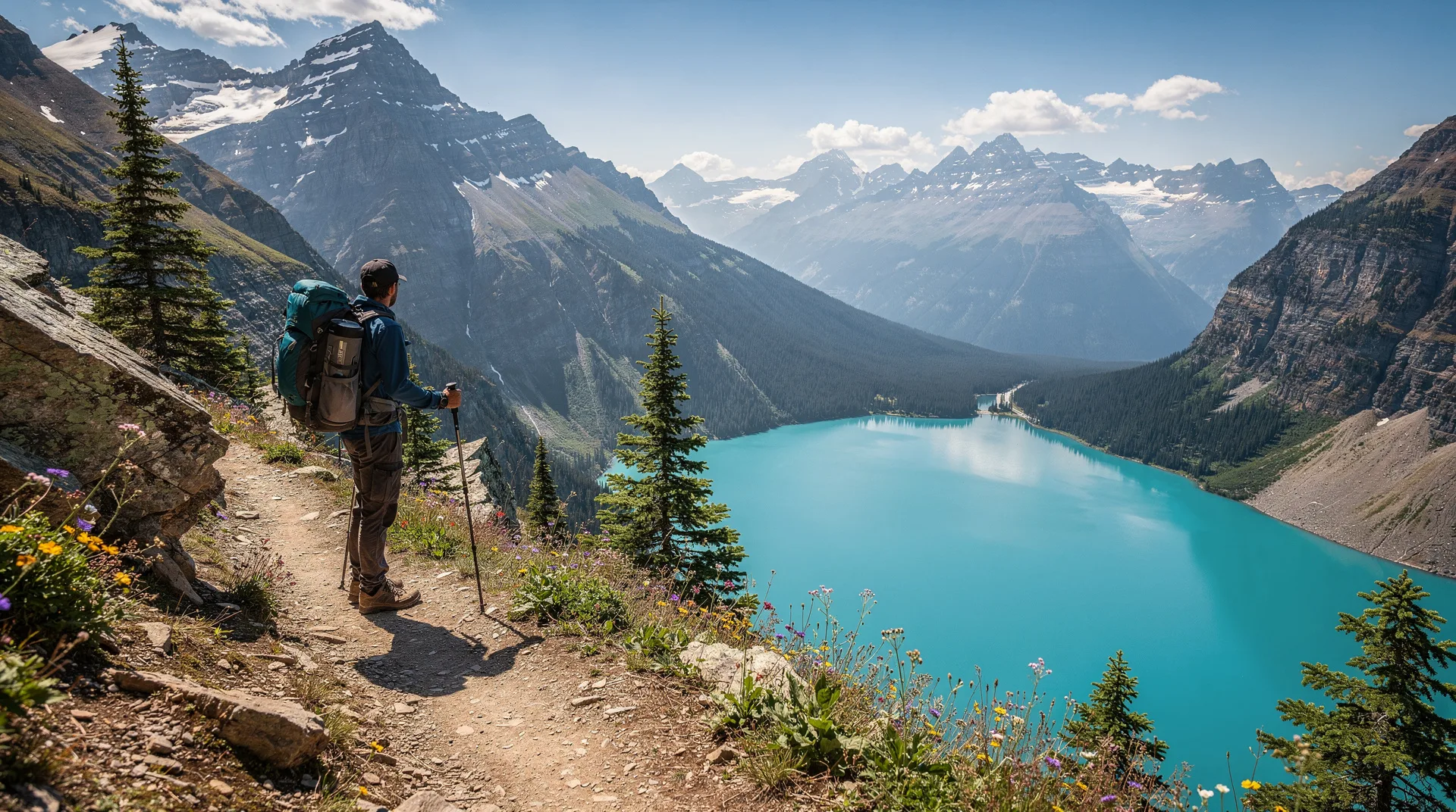
Garibaldi Lake (Squamish)
Difficulty: Moderate-strenuous | Distance: 18 km return | Elevation: 820 m
The definitive Sea-to-Sky hike. Glacial turquoise water, volcanic peaks, the option to extend to Black Tusk (one of the most recognisable summits in BC) or Panorama Ridge. The trail is well-maintained and clearly signed. Parking reservation required in summer. See the full Garibaldi Lake trail guide for complete details.
Stawamus Chief (Squamish)
Difficulty: Strenuous | Distance: 3.2–10 km return (depending on peaks) | Elevation: 410–600+ m
Three granite summit peaks above Squamish, reached by a trail with fixed chains and ladders. Extraordinary views of Howe Sound. Starts at Shannon Falls — combine the two for a half-day adventure. See the Stawamus Chief hike guide.
Black Tusk (Garibaldi Provincial Park)
Difficulty: Strenuous | Distance: 29 km return from trailhead (or 8 km from Garibaldi Lake camp) | Elevation: 1,100 m from trailhead
The volcanic pinnacle that defines the Garibaldi skyline. The summit scramble involves loose volcanic rock and requires comfort with mild exposure. One of BC’s most photographed hiking objectives. Best done as an extension of an overnight at Garibaldi Lake camp.
Panorama Ridge (Garibaldi Provincial Park)
Difficulty: Very strenuous | Distance: 30 km return | Elevation: 1,200 m
The finest viewpoint in Garibaldi Provincial Park, with Garibaldi Lake spread below and the full volcanic landscape visible in every direction. Best as an extension of a Garibaldi Lake overnight.
Joffre Lakes (near Pemberton)
Difficulty: Moderate | Distance: 5.8 km return | Elevation: 370 m
Three glacial lakes, each more vivid than the last, topped by the Matier Glacier. The most rewarding-per-kilometre trail in the Sea-to-Sky corridor. Day-use permit required in summer. See the full Joffre Lakes trail guide.
Elfin Lakes (Squamish)
Difficulty: Moderate | Distance: 22 km return | Elevation: 600 m
The Red Heather meadows and Elfin Lakes in Garibaldi Provincial Park’s Diamond Head area. Less visited than the Garibaldi Lake trail, with equally spectacular subalpine scenery. The Elfin Lakes hut provides backcountry shelter.
Browse guided hiking tours from Vancouver on GetYourGuideVancouver Island
Vancouver Island has two of Canada’s great coastal hiking experiences plus accessible day hikes near Victoria, Nanaimo, and Tofino.
West Coast Trail
Difficulty: Very strenuous | Distance: 75 km | Duration: 6–8 days
Canada’s most celebrated multi-day coastal hike. Old-growth rainforest, sea stacks, ladders, mud, cable cars, and one of the wildest coastlines in North America. Permit and reservation required. Season: May to September. Full details in the West Coast Trail guide.
Juan de Fuca Trail
Difficulty: Moderate-strenuous | Distance: 47 km | Duration: 2–4 days
The accessible coastal alternative. No permit, no quota, year-round access. Four sections between China Beach and Botanical Beach, with tide pools at the western end that are among the best in BC. See the Juan de Fuca Trail guide.
Mount Finlayson (near Victoria)
Difficulty: Moderate | Distance: 4.4 km return | Elevation: 420 m
The most popular summit hike near Victoria, in Goldstream Provincial Park. Rocky scramble to the summit with views of the Saanich Peninsula and Gulf Islands. Excellent for a morning hike before an afternoon in Victoria.
Mount Maxwell (Salt Spring Island)
Difficulty: Easy-moderate | Distance: 4 km return (or drive to trailhead) | Elevation: 190 m from upper parking
A viewpoint trail in Burgoyne Bay Provincial Park with sweeping views across the southern Gulf Islands. Combine with the ferry experience to Salt Spring.
Strathcona Provincial Park
Difficulty: Various | Distance: Various
BC’s oldest provincial park, occupying the central mountains of Vancouver Island. The trail to Flower Ridge, Golden Hinde (Vancouver Island’s highest point), and Augerpoint are multi-day objectives for experienced hikers. Accessible from Campbell River or Gold River.
Whistler and the Callaghan Valley
Whistler’s summer hiking transforms the ski resort into a network of alpine trails accessible by gondola and on foot.
Whistler Mountain trails
Difficulty: Easy-strenuous | Distance: Various | Accessible via gondola
The Whistler Gondola + Peak Chair give access to the High Note Trail (9 km loop with views of Black Tusk and Garibaldi Lake), Musical Bumps (10 km), and Harmony Lake. Day passes for the gondola are required. An excellent option for those who want alpine scenery without the trailhead climb.
Singing Pass
Difficulty: Moderate-strenuous | Distance: 20 km return | Elevation: 900 m
A stunning backcountry valley above Whistler accessible from the Cheakamus Lake trailhead. The Russet Lake hut provides backcountry accommodation with advance reservation.
The Okanagan
The Okanagan’s hiking is dry, sunny, and completely different in character from the coastal and mountain hiking to the west.
Okanagan Mountain Provincial Park
Difficulty: Moderate | Distance: Various (5–25 km) | Near Kelowna
Trails through dry ponderosa pine and bunchgrass terrain above Okanagan Lake. Best in April–June and September–October — summer is too hot. The park’s backcountry trails reach viewpoints above the lake from which the scale of the Okanagan Valley is staggering.
Skaha Bluffs
Difficulty: Easy-moderate | Distance: Various | Near Penticton
Primarily known as a rock climbing area, Skaha Bluffs also has walking trails through the dry canyon country above Penticton. The combination of white granite bluffs, antelope bush, and Okanagan Lake views is striking.
McIntyre Bluff
Difficulty: Moderate | Distance: 8 km return | Near Vaseux Lake
A dry canyon hike south of Penticton with views over Vaseux Lake and the Okanagan Valley. The bluff is also a bighorn sheep habitat — wildlife sightings are common.
Northern BC and the Rockies
Mount Robson Provincial Park
Difficulty: Moderate-strenuous | Berg Lake Trail: 22 km one-way
The Berg Lake Trail to the foot of Mount Robson (the highest peak in the Canadian Rockies) and its floating iceberg lake is one of the finest multi-day hikes in Canada. Reservations required for the campsite and shelter; the hike is on the BC side of the Rockies near Jasper.
Haida Gwaii
Difficulty: Various | Duration: 1 day to multi-day
Haida Gwaii (the Queen Charlotte Islands) is remote, culturally significant, and ecologically extraordinary. The Gwaii Haanas National Park Reserve hiking requires permits and transport by water taxi, but the old-growth forest and ancient Haida village sites make it one of the most profound natural and cultural experiences in Canada.
Spatsizi Plateau Wilderness
Difficulty: Very strenuous | For experienced backcountry travelers only
Remote mountain wilderness in northern BC, accessible by float plane or horse. The Stikine River region and Spatsizi Plateau have some of the most intact large mammal ecosystems in North America — caribou, grizzly bears, mountain goats, wolves.
Practical information
BC Parks reservation system
Many of BC’s most popular backcountry campsites require reservations through BC Parks (bcparks.ca). Reservations open in January for the following season and popular sites (Garibaldi Lake, Joffre Lakes) sell out within hours. Set calendar alerts and be online at midnight on opening day.
Parking reservations
Several heavily-used provincial parks now require advance parking reservations during summer peak season. Garibaldi Lake and Joffre Lakes both have mandatory parking reservation systems. Check the BC Parks website before you go.
Trail conditions
BC Trails (bctrails.ca) and Alltrails have user-reported conditions, but the most reliable source is the BC Parks website for any specific park, combined with local hiking clubs and forums.
Bear safety
Black bears are present throughout BC’s hiking areas. Grizzly bears are present in the northern and Rocky Mountain regions of BC. Carry bear spray in all bear habitat, make noise on the trail, and store food in bear caches or bear canisters. See the grizzly bear viewing guide for more detail on bear safety.
Find guided mountain hiking tours from Whistler on GetYourGuideDifficulty breakdown at a glance
| Trail | Distance | Elevation | Difficulty | Permit |
|---|---|---|---|---|
| Mystic Beach (JDF) | 2.9 km | Minimal | Easy | No |
| Joffre Lakes | 5.8 km | 370 m | Moderate | Parking only |
| Mount Finlayson | 4.4 km | 420 m | Moderate | No |
| Stawamus Chief (First Peak) | 3.2 km | 410 m | Strenuous | No |
| Garibaldi Lake | 18 km | 820 m | Mod-strenuous | Parking |
| Black Tusk | 29 km | 1,100 m | Very strenuous | Camping |
| Juan de Fuca Trail | 47 km | Cumulative | Strenuous | No |
| West Coast Trail | 75 km | Cumulative | Very strenuous | Yes |
| Berg Lake Trail | 44 km | 790 m | Strenuous | Yes |
Seasonal summary
April–May: Okanagan hiking (Skaha, McIntyre Bluff) at their best. Lower elevation Sea-to-Sky trails open. Victoria-area hiking. Juan de Fuca Trail in spring condition.
June–July: Sea-to-Sky alpine trails open mid-June. Joffre Lakes snow-free. Garibaldi Lake accessible. West Coast Trail in full season.
August: Peak conditions across BC. Warmest, driest month. Maximum crowds at popular trailheads.
September: Best month for experienced hikers. Cooler temperatures, thinning crowds, fall colour beginning. All summer trails still in excellent condition.
October–March: Winter hiking in the Okanagan. Coastal and lower-elevation trails year-round with appropriate gear. Alpine trails snow-covered.