Quick facts
- Located in
- Mauricie, Quebec
- Best time
- Jun–Oct (canoeing/hiking) or Jan–Mar (cross-country skiing)
- Getting there
- 180 km NE of Montreal; 160 km W of Quebec City via Hwy 40 then Hwy 55
- Days needed
- 2-5 days
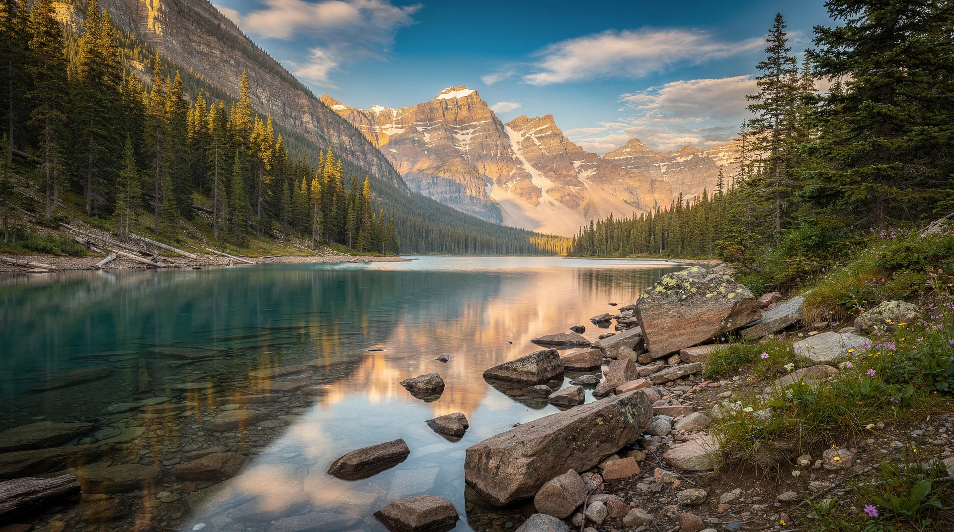
Parc National de la Mauricie is one of Canada’s least-known and most rewarding national parks. A federal Parks Canada park rather than a provincial Sépaq park, it occupies 536 square kilometres of Laurentian Shield plateau between Shawinigan and La Tuque on the Saint-Maurice River’s middle course — a landscape of lakes, ancient forest, and waterways that was shaped by glaciation into an interconnected paddling environment that is genuinely exceptional.
The park was established in 1970 after decades of lobbying by conservationists who wanted to protect the Saint-Maurice basin’s forest from the pulpwood industry that had been harvesting it since the 19th century. The protection came in time to preserve significant stands of old-growth maple, yellow birch, and American beech — forest that in some sections has been undisturbed for over two centuries and has developed the structural complexity that old-growth hardwood forest acquires only over very long periods. The contrast with the managed forest outside the park boundary is immediately visible to anyone who walks from one into the other.
The park has two main access points: the Saint-Jean-des-Piles sector on the southern edge, accessed from Shawinigan; and the Saint-Mathieu sector on the northwest, more remote and less developed. The Saint-Jean-des-Piles sector has the campgrounds, the visitor centre, the canoe rentals, and the trailheads for the park’s most accessible experiences. Most visitors use this entry point.
The Canoe Camping Network
The canoe camping network in Parc National de la Mauricie is the park’s defining feature and the experience that most fully expresses its character. A system of 83 lakes connected by portage routes allows canoe campers to design multi-day journeys through the park’s interior, spending successive nights on different lakes and experiencing the park’s changing landscape from the water.
The portages range from short carries of 100 metres on flat terrain to longer climbs of over a kilometre on rooty and rocky paths. The lake crossings vary from intimate paddles across ponds barely large enough to turn a canoe to open-water crossings of a kilometre or more on the park’s larger lakes. An experienced canoeist can cover three to five lakes per day in good conditions; a more relaxed itinerary spending two nights on the most appealing lakes will extend a week without retracing any route.
The designated campsites on the canoe route are spaced to allow paddlers to reach the next site without excessive fatigue. Each site has a tent platform or cleared tent pad, a fire ring, and a food cache point. No facilities beyond these basics — no toilets, no running water (the lake provides water that requires treatment). The simplicity is intentional.
Canoes are rentable at the Saint-Jean-des-Piles visitor centre, eliminating the need to transport your own. Route maps and portage information are available at the visitor centre and are essential for planning — the lake network is complex enough that navigation without a proper route map requires more experience than casual canoe campers typically have.
For day paddling without an overnight commitment, several of the lakes near the park access road are reachable for half-day excursions. Lac Édouard and Lac Bouchard near the visitor centre are the most accessible day-paddle options.
Book Quebec outdoor adventures and guided canoe trips from Montreal on GetYourGuideWildlife: Moose, Loons, and Bears
Parc National de la Mauricie has some of the highest moose densities of any protected area in southern Quebec. The combination of extensive wetland areas, young forest regenerating on old harvest sites near the park boundary, and the protected status that has allowed the population to reach carrying capacity creates conditions where moose sightings are highly probable for visitors spending two or more days in the park.
The best moose viewing occurs at dawn and dusk at the edges of the park’s lakes and marshy bays, where moose feed on aquatic vegetation through the summer. Several lakes on the canoe route are known to resident park staff as reliable moose viewing areas, and the information shared at the visitor centre often includes current sightings that allow campers to position themselves advantageously.
The loon population is the park’s other signature wildlife attraction. Common loons nest on nearly every interior lake, and the density of the population means that the haunting, far-carrying calls of loons in the early morning and at dusk are the defining sound of an evening in the park’s canoe country. The calls — varying from the tremolo alarm call to the distinctive wail that carries extraordinary distances across still water — are genuinely moving, and experienced campers who have heard them on dozens of evenings describe the first Mauricie loon call of a trip with evident pleasure.
Black bears are present throughout the park. The standard protocols — bear canisters or hanging food at designated cache points, never leaving food in tents — are sufficient to prevent the vast majority of problematic encounters. The bears are shy and will generally avoid contact with groups of hikers or paddlers; solo travellers and very small groups encounter them occasionally.
Otters, beaver, white-tailed deer, mink, and osprey are all regularly observed by attentive visitors. The park’s fish-hawk (osprey) population is visible throughout the summer, particularly at the larger lakes where they hunt at the surface with dramatic plunge-dives.
Hiking Trails
The park’s trail network covers approximately 100 kilometres through a variety of terrain, ranging from the flat lakeside paths near the visitor centre through to the more demanding ridgeline and summit routes in the park’s interior.
The Sentier de la Wabasso is the park’s signature hiking trail — a 9-kilometre loop through old-growth forest to a ridgeline viewpoint over the interior lakes. The forest through which the trail passes includes some of the park’s most ancient yellow birch and sugar maple, and the sense of an undisturbed ecosystem — the fallen logs at various stages of decomposition, the multilayered canopy, the absence of the species homogeneity that characterises managed forest — gives the walk a quality that deliberately accessible nature trails do not provide.
The Sentier du Lac Bouchard loops around one of the park’s accessible interior lakes through lowland mixed forest and is the most family-appropriate trail option — flat, clearly marked, and rewarding in the lakeside views it provides without requiring significant hiking fitness. The lake at the trail’s centre can be accessed for swimming or picnicking from the shore access points at several points along the loop.
The Sentier des Roches is a shorter and steeper route that climbs through the park’s Canadian Shield terrain to viewpoints over the Saint-Maurice River valley and the surrounding forest. The exposed granite of the trail’s upper section gives views that the forested lower terrain denies.
In winter, the trail network is converted for snowshoeing, and a subset of the trails is groomed for cross-country skiing.
Cross-Country Skiing and Winter
The park operates one of the most complete winter trail networks in the Mauricie region — approximately 80 kilometres of groomed skiing and 60 kilometres of snowshoe trails through the same forest that provides the summer hiking. In winter, the character of the Laurentian Shield plateau changes fundamentally: the lakes freeze silent and white, the hardwood forest is bare and transparent, and the boreal elements — the spruce and fir that were background presences in summer — become dominant.
The groomed ski trails range from gentle beginner routes around the visitor centre to demanding multi-kilometre back-country traverses that reach the park’s interior. Warming huts at regular intervals along the trails provide shelter and heating on cold days. Winter camping — in the heated trail-side refuges that Parks Canada operates — is available for those who want the full winter immersion experience.
The winter access to the park is from the same Saint-Jean-des-Piles entry point as summer. The access road within the park is ploughed to the main facilities; beyond that point, winter travel is on skis or snowshoes. Cross-country ski rentals are available at the park.
Fishing
The park’s lakes support healthy populations of walleye, pike, brook trout, and lake trout. Fishing is permitted with a provincial licence (Quebec fishing licence required for all anglers, including visitors from other provinces) and in accordance with the park’s specific regulations — catch limits and size restrictions apply, and certain lakes may have specific restrictions.
Brook trout fishing in the smaller tributary streams and ponds during the spring season — from ice-out through early summer — is the park’s most productive fishing experience for those who combine it with a canoe camping trip. The park’s information centre can advise on current conditions and productive locations for the season.
Camping and Accommodation
The Rivière-à-la-Pêche campground near the Saint-Jean-des-Piles sector entrance is the park’s main frontcountry campground — tent sites and serviced sites with shower facilities, a beach, and canoe rentals. This is the base for day visitors and for campers who want full facilities rather than backcountry conditions.
The backcountry canoe route campsites must be reserved in advance through the Parks Canada reservation system, which opens in late winter and fills quickly for July and August. A Parks Canada Discovery Pass covers entry to the Mauricie park and all other national parks and historic sites across Canada, providing excellent value for visitors planning a multi-park itinerary.
The park also operates a limited number of oTENTik units — large canvas tent structures on raised platforms with beds, basic kitchen equipment, and electric lighting — that provide a comfortable camping experience without requiring tent equipment. These units are consistently popular and should be reserved well in advance.
Getting There and Practical Information
The Saint-Jean-des-Piles main access is reached via Highway 55 north from Trois-Rivières to exit 217, then Route 155 northwest toward the park. From Montreal, take Highway 40 east to Trois-Rivières (150 km, 1.5 hours), then Highway 55 north — total distance approximately 180 km from Montreal. From Quebec City, the route reverses via Highway 40 west, reaching the park in approximately 160 km.
Parks Canada charges a daily entry fee (adult approximately CAD 9.00, exact rates are updated annually and available on the Parks Canada website). The fee applies to all visitors entering the park by vehicle.
Cell coverage inside the park is extremely limited. Downloading offline maps before entry is strongly recommended. The Parks Canada national park app includes offline capability for the Mauricie park’s trail network.
Discover Canada’s national parks and outdoor experiences on GetYourGuideFor the full Mauricie context, the Mauricie region guide covers Trois-Rivières, Shawinigan, and Lac Sacacomie alongside the national park. The park is best combined with a night in Trois-Rivières before heading north into the Saint-Maurice River valley — and with Shawinigan’s Cité de l’Énergie on the return.