Quick facts
- Located in
- Eastern Townships (Cantons-de-l'Est), Quebec
- Best time
- Jun–Oct (hiking/paddling) or Dec–Mar (skiing)
- Getting there
- 115 km east of Montreal via Hwy 10 (1 hr 15 min)
- Days needed
- 1-3 days
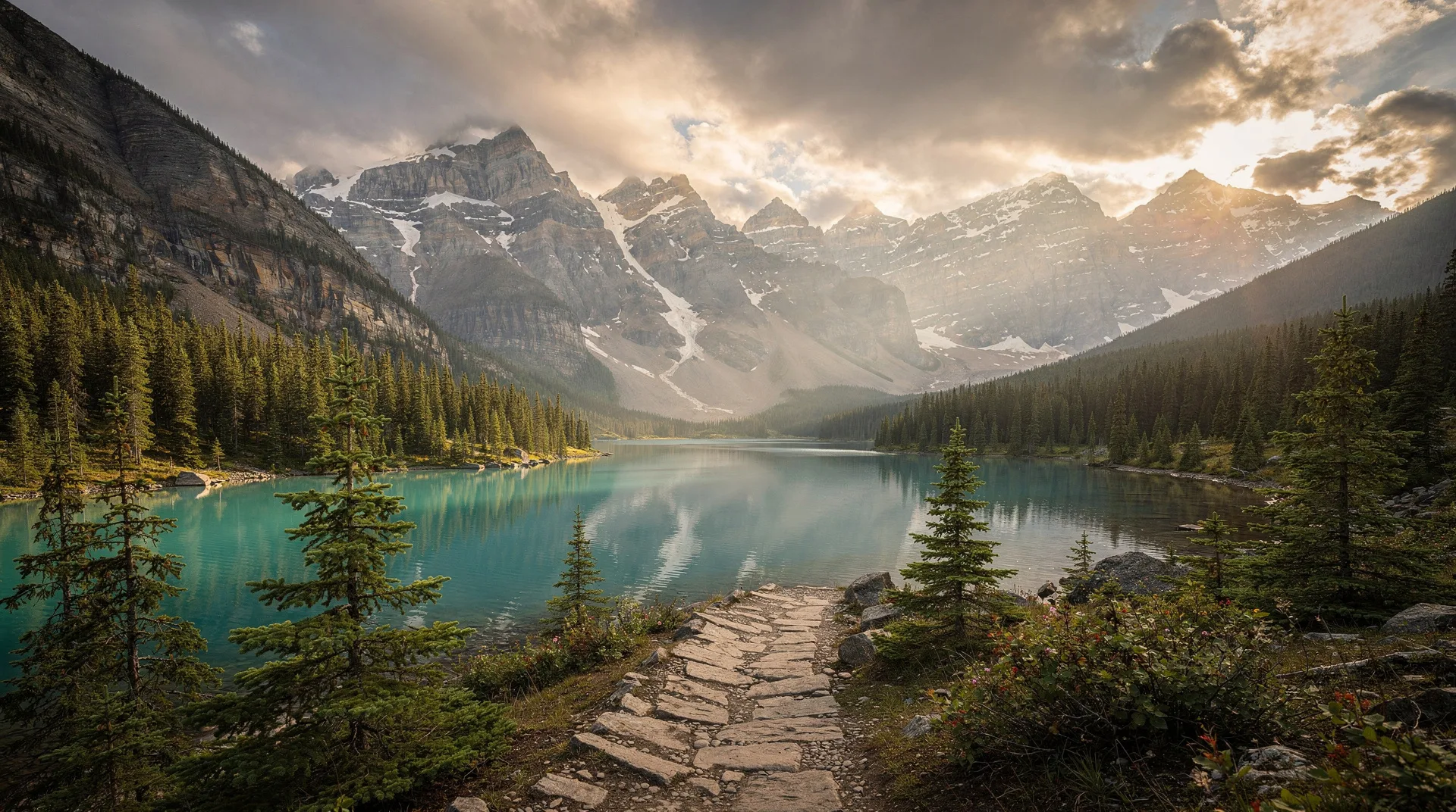
Parc National du Mont-Orford packs a lot of landscape into a relatively compact protected area. The 58-square-kilometre park encompasses the rounded summit of Mont Orford — at 853 metres the highest point in the Eastern Townships south of Sherbrooke — along with three lakes, extensive hardwood forest, and the ski area that serves both the resort crowd from Magog and the park’s winter visitors. From the summit on a clear day, the view south over Lac Memphrémagog’s 45-kilometre length — disappearing into Vermont in the distance — is one of the finest panoramas in Quebec south of the St. Lawrence.
The park was established in 1938 and remains one of the oldest protected areas in the Eastern Townships. Its Appalachian forest — dominated by sugar maple, yellow birch, and American beech at lower elevations, transitioning to boreal species near the summit — has a character distinct from the Laurentian forests further north. The species composition reflects the park’s position at the northern edge of the Temperate Deciduous Forest Zone, and the biodiversity it supports — including species that reach the northern limit of their range here — gives it ecological significance beyond its modest size.
The proximity to Magog (5 kilometres) and the Highway 10 corridor makes Mont-Orford one of the most accessible national parks in Quebec. Day visitors from Montreal can reach the park gates within 75 minutes of leaving the city, making it a realistic destination for a single-day outing. The campgrounds and rental accommodations allow multi-day stays that give access to the park’s trails and lakes beyond what a day visit permits.
Hiking: Summit Trails and Forest Walks
The summit of Mont Orford is the primary hiking objective, accessible via multiple trails that vary in difficulty and route character. The most direct ascent from the Lac Stukely sector follows the Sentier de la Croix to the summit ridge and takes approximately 2.5–3 hours return for fit hikers. The summit terrain is exposed granite with panoramic views in all directions — north over the rolling Appalachian hills toward the Laurentians, south over Lac Memphrémagog and into Vermont, and east toward Sherbrooke and the broader Townships landscape.
The Sentier des Crêtes (Ridgeline Trail) is the park’s most ambitious hiking route — a traverse along the ridgeline connecting Mont Orford’s summit with the adjacent peaks of Mont Chauve and Mont Alfred-Desrochers. The full traverse covers approximately 22 kilometres one-way and is typically done as an overnight backpacking trip with the park’s designated backcountry sites. The ridgeline terrain is exposed in sections and requires a clear weather window; the views on good days are among the finest in the Eastern Townships.
Lower-difficulty options concentrate around the lake shores and the valley terrain between the park’s peaks. The trail around Lac Stukely — approximately 5 kilometres, flat, with consistent lake views — is the park’s most popular shorter route and is accessible for families with young children. The lakeside forest is particularly beautiful in fall colour, with the reflected colours on the lake surface adding a visual dimension not available on the exposed summit.
The Sentier des Marécages (Wetlands Trail) in the valley near the park entrance interprets the park’s lowland ecology through an accessible boardwalk route that passes through beaver pond areas and streamside forest. The birdlife in the wetland zone — herons, various duck species, and the occasional kingfisher — is consistently rewarding.
Book an Eastern Townships nature tour or day trip from Montreal on GetYourGuideSkiing at Mont-Orford
The ski area at Mont-Orford operates on the park’s mountain terrain — a somewhat unusual arrangement that places downhill skiing infrastructure within a provincial park boundary. The result is a ski area with a genuine wilderness backdrop rather than a resort-village aesthetic, and the combination of skiing and national park access on the same terrain is distinctive.
Mont-Orford has 61 runs across 405 metres of vertical, with a north-facing orientation that preserves snow quality through the season. The resort is mid-sized by Quebec standards — larger than Sutton and competitive with Bromont in total terrain — and draws primarily from the Sherbrooke and Eastern Townships population rather than the Montreal day-trip market that Bromont captures.
The expert terrain at Mont-Orford is solid rather than exceptional — there are demanding runs and some natural glade terrain, but the mountain lacks the reputation for technical difficulty that Mont Sutton has earned. For intermediate and family skiing, Mont-Orford is excellent: the runs are well-maintained, the lift infrastructure is efficient, and the mountain backdrop over Lac Memphrémagog makes the experience visually distinctive from most Quebec ski hills.
Cross-country skiing is available on designated trails within the park separate from the downhill area. The groomed network of approximately 35 kilometres includes trails through the hardwood forest and around the lake shores, with warming huts at regular intervals. The Lac Stukely circuit in particular offers classic cross-country skiing terrain with the lakeside scenery as a constant reference.
Paddling on the Park Lakes
Lac Stukely and Lac Fraser, within the park boundaries, provide paddling access that is distinct from the open-water experience on Lac Memphrémagog. Both lakes are smaller, more enclosed, and surrounded by forested park terrain that gives the paddling experience a wilderness quality despite the proximity to the highway and the resort facilities.
Lac Stukely, the larger of the two at approximately 3.5 kilometres in length, has a sandy beach at its southern end and a campground on its western shore. Canoe and kayak rentals are available at the lake in summer. The lake is deep enough to be genuinely cold through July, and the morning mist that rises from the water in late summer and early fall creates a visual effect that makes early-morning paddling particularly evocative.
The smaller Lac Fraser provides a quieter paddling experience with fewer visitors and a more enclosed forest setting. For campers based at the Lac Fraser campground, the lake provides convenient paddling access without the beach-day crowds that Lac Stukely attracts on summer weekends.
Fall Colour at Mont-Orford
The fall colour in Parc National du Mont-Orford is among the finest in the Eastern Townships — the park’s Appalachian forest composition, dominated by sugar maple and yellow birch, creates a colour palette that includes deep reds, brilliant oranges, and clear yellows in a pattern that reflects the varying elevation and species distribution across the mountain.
The peak colour typically arrives at the summit and upper elevations in the third week of September and moves downward to the lake shores and valley floor through the first two weeks of October. The gradient of colour — from the early-turning summit down through the still-green lower forest — creates a visual complexity on the mountain face that is particularly striking.
The summit trail in peak colour is the park’s most popular hiking experience of the year, and weekend crowds at the trailhead can be significant. Weekday hiking in colour season — particularly Tuesday through Thursday in late September — offers the best trail experience without the weekend congestion at the parking areas.
The view from the summit over Lac Memphrémagog in peak colour is extraordinary: the lake’s dark blue contrasting with the orange and red forest on the surrounding hillsides, extending south to the Vermont border. This is one of the defining visual experiences of fall in the Eastern Townships.
Camping and Accommodation
The park’s campgrounds at Lac Stukely and Lac Fraser operate from mid-May through mid-October and provide both tent sites and serviced sites for RVs. The Lac Stukely campground is the larger and more developed, with shower facilities, a beach, and canoe rentals. Reservations through the Sépaq system are strongly recommended for summer weekends and are essential for the peak colour weeks in October.
Backcountry camping is permitted at designated sites accessible on foot from the trailheads, allowing overnight hikers to base themselves near the summit or on the ridge traverse. The backcountry sites are simple — no facilities, fire rings only — and must be booked in advance through Sépaq.
The park also operates a series of rental accommodations — basic chalets and camping shelters — that provide more comfortable alternatives to tent camping. These units are popular with families and are typically booked significantly in advance for summer and the peak colour period.
Getting There
The park’s main entrance is reached from the town of Orford, accessed via Highway 10 east from Montreal to exit 115 (Orford), approximately 115 kilometres and 1 hour 15 minutes from central Montreal in normal traffic. From Magog, the park entrance is 5 kilometres north on Route 141 — a convenient combination for visitors staying in Magog who want to day-hike in the park.
The Sépaq day-use fee applies for entry — currently CAD 9.25 per adult. The annual Sépaq pass covering all Quebec national parks provides excellent value for visitors making multiple park visits.
Mont-Orford is best combined with a stay in Magog for lake access and town amenities, or with exploration of the Route des Vins and Sutton on a broader Eastern Townships itinerary. The Eastern Townships guide provides the full regional planning context.