Dempster Highway 7-Day Road Trip: Whitehorse to Tuktoyaktuk
Overview
The Dempster Highway road trip from Whitehorse to Tuktoyaktuk on the Arctic Ocean is one of the great drives in North America — 870 kilometres of gravel road (from the Dempster junction, 40 km east of Dawson City) connecting the Yukon’s capital to the Arctic Ocean shore, crossing the Arctic Circle, passing through Tombstone Territorial Park, the Eagle Plains plateau, the Richardson Mountains, the Mackenzie Delta, and ending at Tuktoyaktuk where road and ocean meet.
This 7-day itinerary covers the full route out and back — drive north to Tuktoyaktuk in 3 days, spend a day at the ocean, and return south with more time for stops. The alternative is flying back from Inuvik, but the return drive with extra time for stops makes the journey richer.
| Day | Route | Driving |
|---|---|---|
| 1 | Whitehorse → Dawson City | 536 km, 6 hrs |
| 2 | Dawson City → Tombstone → Eagle Plains | 369 km, 5 hrs |
| 3 | Eagle Plains → Arctic Circle → Inuvik | 366 km, 5 hrs |
| 4 | Inuvik → Tuktoyaktuk (and return) | 274 km return, 4 hrs |
| 5 | Inuvik → Eagle Plains → Tombstone | 369 km, 5 hrs |
| 6 | Tombstone → Dawson City | Relaxed day |
| 7 | Dawson City → Whitehorse | 536 km, 6 hrs |
Before you go — vehicle requirements: Two spare tires (not negotiable). Full tank before every fuel stop. Vehicle clearance at least sedan level, but higher is better. Check rental car agreement for gravel road permissions. Carry emergency supplies: sleeping bag, food for 2 days, water, jumper cables, tow rope, basic tools.
Season: Late June to mid-September for summer driving. February–March for winter ice road to Tuktoyaktuk and aurora. The ferry crossings (Peel River and Mackenzie River) operate approximately June to October. Check Yukon/NWT government road conditions before departing.
Budget reality: The Dempster corridor is remote and expensive. Budget CAD 350–550 per day for two people: accommodation (Eagle Plains Hotel is the only option along the 369-km stretch), meals at northern prices, and fuel at remote rates. The total 7-day trip budget for two runs approximately CAD 2,500–4,000 excluding the Whitehorse rental vehicle.
Book Whitehorse guided tours and wilderness experiences before your Dempster departureDay 1: Whitehorse to Dawson City
The 536-kilometre drive north on the Klondike Highway (Hwy 2) is a full day’s drive with rewarding stops.
Depart Whitehorse early: Fill the tank in Whitehorse. The next reliable fuel stop is Carmacks (177 km). Departure by 7–8 AM gives you the best chance of arriving in Dawson City by early evening with time for the ferry crossing and exploration.
Stop: Takhini River bridge (30 km north of Whitehorse): A brief pause to scan the river for moose and waterfowl. The Takhini is moose country — the wide, slow-moving river channel with its willow margins is classic moose habitat.
Stop: Braeburn Lodge (km 99): A roadhouse on the Klondike Highway known for its cinnamon buns — genuinely large, genuinely good, appropriately northern. Coffee, fuel, and a brief break.
Stop: Five Finger Rapids (near Carmacks): The Yukon River narrows around four rocky pillars; the short trail to the viewpoint above the rapids is worth 30 minutes. The rapids are navigable by modern canoes but were a significant obstacle for the gold rush sternwheelers.
Carmacks: Fuel up at Carmacks (the only stop between Whitehorse and Stewart Crossing for fuel). The community has a small café and territorial campground if you prefer a more relaxed Day 1 timeline.
Stewart Crossing to Dawson City (km 360–536): The road climbs into the Ogilvie Mountains foothills, with increasingly dramatic scenery as you approach the Klondike River valley. The descent to the Klondike-Yukon confluence and the Dawson City ferry crossing is one of the best approaches in the Yukon.
Dawson City ferry: The free government-operated ferry across the Yukon River to the Dawson City townsite runs from 5 AM to midnight in summer (later on high-traffic days). Cross, drive into the historic townsite, and find your hotel.
Evening: Walk Front Street along the Yukon River. Diamond Tooth Gertie’s for the cancan show and the atmosphere. Early to bed — the Dempster starts tomorrow.
Day 2: Dawson City to Eagle Plains via Tombstone
Today the Dempster begins.
Morning in Dawson City: Even with an early Dempster departure, 90 minutes in Dawson City repays the time. The Tr’ondëk Hwëch’in Heritage Centre on Front Street provides the most important context for what you’re about to drive through — this is Tr’ondëk Hwëch’in and Gwich’in territory, and the land you’ll pass through has been inhabited and traveled for thousands of years.
The Dempster junction (km 40 east of Dawson on the Klondike Hwy): The Dempster Highway begins where a gravel road turns off the paved Klondike Highway into the boreal interior. The sign says “Inuvik 735 km.” Tighten the lug nuts on your spare and go.
Stop: Tombstone Territorial Park Interpretive Centre (km 71): Stop here regardless of how late you’re running. The centre provides:
- Current wildlife activity updates (current grizzly locations)
- Trail conditions
- Camping registration if you’re staying the night
- The defining Tombstone Mountain view from the parking area
Tombstone hiking: If you have 2–4 hours, hike the Goldensides Trail (8 km return, 550m elevation gain) to the ridge with the panoramic view of Tombstone Mountain and the North Klondike River valley. This is one of the Yukon’s finest day hikes. Alternatively, the short walking trails around the interpretive centre provide the mountain views without significant effort.
Wildlife alert: Grizzly bears are genuinely common in Tombstone. Be loud on the trail, carry bear spray accessible, and pay attention. Dall sheep are visible on the ridgelines with binoculars.
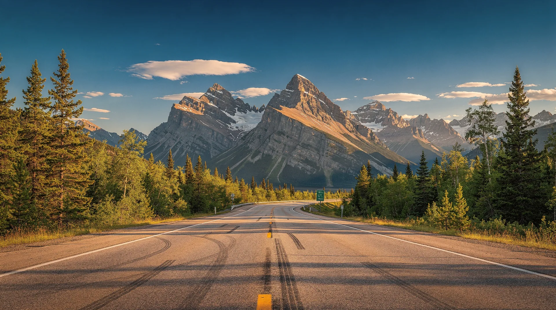
North from Tombstone: The highway climbs through the Ogilvie Mountains — open tundra above treeline, long views, and the Dempster’s characteristic black gravel surface against the gold and green tundra. Engineer Creek (km 196) is a good midpoint stop; the creek is accessible from the road and has Arctic grayling.
Eagle Plains Hotel (km 369): The only accommodation between the junction and Fort McPherson. Reserve in advance — this is the only option. The hotel has rooms (basic, expensive), fuel, and a restaurant. The atmosphere — a remote roadhouse in absolute wilderness, patronised by Dempster regulars, truckers, and adventurous tourists — is authentic. The restaurant serves adequate food at northern prices.
Day 3: Eagle Plains to Arctic Circle to Inuvik
The day crosses the Arctic Circle and arrives in the NWT capital.
Morning fuel at Eagle Plains: Full tank before departing. The next stop is Fort McPherson, approximately 180 km from Eagle Plains via the Arctic Circle.
Arctic Circle (approximately km 405 from the junction): The sign marking the Arctic Circle is the Dempster’s most photographed waypoint. Stand at 66.5°N, the theoretical boundary above which the sun doesn’t set on the summer solstice. In June, the midnight sun from this marker is precisely what the name implies.
The Richardson Mountains: North of the Arctic Circle, the highway climbs into the Richardson Mountains — the range forming the Yukon-NWT border. This is the Dempster’s most dramatic mountain terrain: open tundra ridgelines, sweeping views toward Alaska to the west, and the gradual descent into NWT river country on the far side. The NWT border sign marks the transition between Yukon and Northwest Territories jurisdiction.
Fort McPherson (km 549): Stop for fuel. This is a Gwich’in First Nation community — the site of the “Lost Patrol” RCMP tragedy in 1910-11 and the place where Inspector Francis Dempster’s patrol met its end. The community has a store and basic facilities. The cemetery is historically significant if you have time for a respectful visit.
Peel River ferry: The free government ferry crosses the Peel River near Fort McPherson — the first of two river crossings. Wait times can be brief or lengthy depending on traffic.
Tsiigehtchic (km 626): The second ferry crossing, over the Mackenzie River. Tsiigehtchic (Arctic Red River community) sits at the confluence of the Arctic Red River and the mighty Mackenzie — Canada’s longest river. The scale of the Mackenzie here, with the Richardson Mountains visible upstream, is impressive.
Inuvik (km 735 from junction): Arrive in the western Arctic’s regional hub. Check in to your accommodation (see the Inuvik guide for options). The Arctic Chalet or Mackenzie Hotel are the main choices.
Inuvik evening: Walk to the round Our Lady of Victory Church (the igloo church). The Mad Trapper Pub for dinner and the social centre of Inuvik. Tomorrow is the Arctic Ocean.
Day 4: Inuvik — Tuktoyaktuk — Inuvik
The day drive to Tuktoyaktuk and back covers 274 kilometres of the Inuvik-Tuktoyaktuk Highway — Canada’s most recently completed public road, opened in 2017, crossing the Mackenzie Delta and the Tuktoyaktuk Peninsula to the Arctic Ocean coast.
Depart Inuvik by 8 AM: The drive to Tuktoyaktuk takes approximately 2 hours. The highway passes through stunning delta terrain — flat, lake-studded, and open to the sky in all directions — before climbing slightly to the Tuktoyaktuk Peninsula tundra.
Arrive Tuktoyaktuk: Drive to the shore. Walk to the Arctic Ocean (Beaufort Sea, specifically Kugmallit Bay). Wade in. Take the photograph. The water is approximately 2°C in July; the involuntary sharp breath upon contact is the appropriate response.
Pingo Canadian Landmark: The Ibyuk Pingo, visible from the community, is the second largest pingo in the world — an ice-cored hill 49 metres high that has taken centuries to form. Walk to the landmark viewing area and take in what permafrost geology looks like at landscape scale.
Beluga watching: Ask locally about current beluga activity in Kugmallit Bay. July is peak beluga season; community members sometimes offer small-boat observation trips. The bay’s shallow waters and the Mackenzie River freshwater plume create productive beluga habitat.
Lunch: Bring your own food from Inuvik (no restaurants in Tuktoyaktuk suitable for tourist lunch service; the community store provides basics).
Return to Inuvik: Afternoon drive back (2 hours). The return with the knowledge of what’s at the north end of this road gives the second drive a different quality than the first.
Evening in Inuvik: Enquire at the tourism office about Mackenzie Delta boat tours — evening tours are possible in the long summer light, with beluga whale and wildlife spotting in the delta channels.
Browse Yukon and western Arctic road trip and wilderness experiencesDay 5: Return — Inuvik to Tombstone area
The return drive south reverses the route with more time for stops missed on the northward journey.
Fuel in Inuvik before departing: Standard Dempster discipline.
Mackenzie River ferry at Tsiigehtchic: A second crossing of the Mackenzie — with more time now, walk to the riverbank above the ferry landing and absorb the scale of Canada’s largest river system. The confluence of the Arctic Red River is immediately visible.
Fort McPherson: Stop for fuel. Browse the community craft store if time permits — Gwich’in craftwork including beadwork and traditional items is sometimes available.
The Richardson Mountains southbound: The mountain crossing southbound reveals different light and views than the northbound direction. In late afternoon, the western slopes are in shadow and the eastern views toward the Mackenzie Lowlands open up.
Camp or hotel at Tombstone: If you’re camping, return to Tombstone Territorial Park campground (km 71.5) for a night under the peaks. If camping isn’t your preference, continue to Dawson City (a further 71 km) for hotel accommodation.
Tombstone at dusk: The late-evening light on Tombstone Mountain and the surrounding quartzite peaks is extraordinary in summer — the low angle of a Yukon sun at 9 PM turns the black rock to warm charcoal with orange highlights. Wildlife is active in the late-evening hours; grizzly sightings on the valley floor and Dall sheep on the ridgelines are most common in the early morning and late evening.
Day 6: Tombstone and Dawson City
With the pressure of the northward journey removed, this day has time for the Dempster properly.
Morning Tombstone hiking: Today try the Grizzly Lake trail (12 km return) if conditions permit — the backcountry trail into the cirque lake beneath the peaks that gives the park its character. Register at the interpretive centre before departing and carry bear canisters (mandatory for overnight; recommended for the day hike as well).
Alternatively: The Goldensides Trail (if you didn’t hike it on Day 2) provides the panoramic ridge experience without the backcountry distance.
Drive to Dawson City (km 0, 40 km to the Klondike junction): Arrive in early afternoon.
Dawson City afternoon: What was rushed on Day 1 can be properly explored now. Dredge No. 4 (open until 5 PM in summer) — the massive gold dredge on Bonanza Creek is the most impressive Parks Canada site in the city. Robert Service’s Cabin readings at 3 PM. Dawson City Museum for the gold rush collection.
Evening: Bullock’s Bistro if you missed it earlier. Diamond Tooth Gertie’s cancan show at 8:30 PM.
Day 7: Dawson City to Whitehorse — the return south
Morning in Dawson City: Use the time before departure for what you missed. The Tr’ondëk Hwëch’in Heritage Centre if you haven’t been. The Top of the World Highway viewpoint (15 minutes east of town) for a panoramic view of the Yukon-Klondike country.
The 536-kilometre return: The Klondike Highway south to Whitehorse is a full day’s drive. Stops on the way back can be different from the northbound journey:
- Pelly Crossing (km 200): Selkirk First Nation community with a small cultural centre and the Pelly River — a major Yukon River tributary
- Carmacks (km 360): Fuel stop and the Five Finger Rapids viewpoint if not visited northbound
- Lake Laberge (km 30 from Whitehorse): The lake immortalised in Robert Service’s “Cremation of Sam McGee” is visible from a short access road off the highway — a worthwhile brief stop to connect geography and literature
Arrive Whitehorse: Return rental vehicle (be prepared to explain the spare tire situation if you used one — carry the receipt from wherever you purchased a replacement). Celebration dinner in Whitehorse.
Stay: One night in Whitehorse before your departure flight the following morning, or fly out of Whitehorse the evening of Day 7 if timing works.
Key logistical details
Ferry schedules: Both the Peel River and Mackenzie River ferries operate June through early October, approximately 24 hours per day (with brief maintenance breaks). Check the Yukon and NWT government road condition sites the morning you plan to cross.
Cell service: Zero for most of the Dempster corridor. Download offline maps before departing. Carry a satellite communicator (Garmin inReach or SPOT) for emergencies — not optional if you are driving remote roads solo.
Fuel prices: Eagle Plains fuel runs approximately 50–70% above Whitehorse prices. Fort McPherson is comparable. Budget this into your fuel calculations.
The bear spray requirement: Essential for any hiking on the Dempster, particularly in Tombstone. Grizzly bears are common and the landscape is open enough to see them at distance — the challenge is the dense shrub areas near creek crossings where encounters are closer and quicker.
Related guides
For detailed coverage of individual destinations on this route, see: Tombstone Territorial Park, Dempster Highway guide, Inuvik guide, Tuktoyaktuk guide, and Dawson City gold rush history. The Yukon 7-day itinerary covers the Whitehorse-Kluane-Dawson southern circuit as a companion trip to this one.