The Cabot Trail: Canada's most scenic drive
There are drives that are described as scenic and drives that earn the description without qualification. The Cabot Trail is the latter — a 300 km loop around the northern tip of Cape Breton Island in Nova Scotia that passes through Cape Breton Highlands National Park, along cliff edges above the Gulf of St Lawrence and the Atlantic Ocean, through forest that turns extraordinary colours in autumn, and past fishing villages and Mi’kmaw and Gaelic communities whose cultural character is specific to this corner of Canada in ways that no other part of the country quite replicates.
I have driven the Cabot Trail four times: once in summer, twice in autumn at different points in the colour season, once in May with the road almost entirely to myself. Each time it has given me something different. Each time I have left with the sense that I had only begun to understand it.
The basics: direction, timing, and logistics
The Cabot Trail is a loop — it begins and ends at the Trans-Canada Highway junction near Baddeck, and you can drive it in either direction. The choice matters more than most sources suggest.
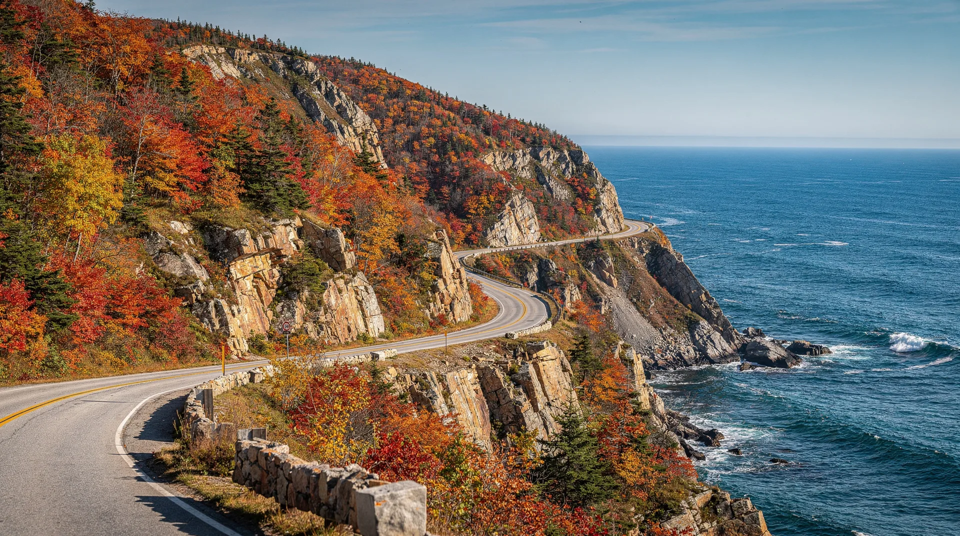
Counterclockwise (heading northwest from Baddeck toward Margaree Harbour and Chéticamp before entering the park from the west) is the recommended direction for most drivers. The reason: this puts you on the cliff-edge side of the road — on the outside lane, closest to the ocean — for the most dramatic section of the drive, the ascent and traverse of the highlands’ western plateau and the descent to the Gulf of St Lawrence coast. The views directly down to the water from several hundred metres up are best experienced from the cliff side rather than the mountain side.
Clockwise (heading east first through Englishtown and Ingonish before climbing into the park) is a legitimate alternative if you want to arrive at the western section later in the day when the late-afternoon light hits the cliffs from behind you.
The loop takes a minimum of six hours at driving pace with stops. A full day is realistic for a through-drive with proper time at the major viewpoints and a short walk. Two days allows genuine hiking. Three days is enough to feel like you’ve actually inhabited the place.
Accommodation options include several inns and B&Bs within or adjacent to the park, a few motel-style properties in Chéticamp and Ingonish, and parks campgrounds at several locations on the loop.
The western coast: cliffs, fishing villages, and the ascent
Driving counterclockwise, the route follows the Margaree Valley north from Trans-Canada — a wide, green river valley with some of the best Atlantic salmon fishing in eastern Canada — before hitting the Gulf of St Lawrence coast at Margaree Harbour and turning north along the water.
Chéticamp, 50 km north, is the most significant Acadian community in Nova Scotia — French-speaking, with a distinctive culture that includes traditional hooked-rug making and a culinary tradition centred on fish and seafood. The L’Escalier bakery in the village makes the best meat pies in Cape Breton; the cooperative Acadian museum gives excellent context for what makes this community distinct. Stop here before entering the park and buy food for the drive.
The western plateau ascent begins just north of Chéticamp. The road climbs in switchbacks from sea level to around 450 metres in a few kilometres, and the views open up as you climb — back down to the Gulf, to the fishing harbour at Chéticamp, to the long southwestern curve of the coast. The French Mountain Lookout at the top is the first of several places where you will want to get out of the car.
Cape Breton Highlands National Park
The park encompasses the entire northern tip of Cape Breton — a plateau of subarctic terrain ringed by mountain slopes that drop steeply to the sea on three sides. The plateau itself is covered in bogs, stunted spruce, and wild meadows that in October become extraordinary mixtures of russet, gold, and the deep green of the spruce.
The Skyline Trail is the park’s signature hike and one of the finest short walks in eastern Canada: 9 km return to an ocean lookout on the cliff edge of the western plateau, with panoramic views of the Gulf of St Lawrence extending to the horizon. Bald eagles circle the thermals above the cliff edge regularly. The walk is mostly flat with one descent and re-ascent to the lookout — appropriate for most fitness levels. Allow three to four hours.
The Fishing Cove trail drops 365 metres from the plateau to a small river cove on the Gulf coast, accessible only on foot — one of Cape Breton’s most beautiful remote beaches, and the starting point for a backcountry camping route if you have the permits and the time. The ascent back up is genuinely strenuous.
Several shorter walks along the road allow access to the plateau without full day hikes: the Lone Shieling trail through an old-growth maple grove to a replica Scottish Highland stone cottage (45 minutes), the Green Cove viewpoint (10 minutes from the road), the Corney Brook picnic area.
Guided tours of Cape Breton Island including the Cabot Trail are available for travellers who prefer not to self-drive — particularly useful if you’re arriving without a car from Halifax or arriving by cruise ship at Sydney.
The eastern coast: the descent and the Ingonish shore
The road drops from the plateau to the Atlantic coast on the park’s eastern side, the descent revealing the Aspy River valley and the blue of the Atlantic beyond. The northern tip of Cape Breton around Cape North is the quietest and most remote part of the loop — the small communities here have a distinctly end-of-the-road character.
Ingonish, on the eastern shore, is the park’s main eastern service centre: the Keltic Lodge (a classic resort in the cape Breton highland tradition, worth visiting even if you’re not staying), the Freshwater Lake swimming area, and the beginning of the Middle Head peninsula trail — a 4 km loop out onto a dramatic headland between two bays, with views of the Atlantic in both directions.
The road from Ingonish south to Englishtown passes through the Highlands’ eastern escarpment — not as dramatic as the western side but still beautiful, with the green ocean valleys below the road and the plateau above.
When to go: the seasonal case for October
Summer is the most popular season and for good reason — the weather is warmest, the park facilities are fully open, and the days are long. But the Cabot Trail in early October, when the maple and beech trees on the highland slopes are at peak autumn colour, is genuinely different: more vivid, more emotional, and far less crowded than summer.
The colour season typically runs from late September through the second week of October, with peak intensity around the first week of October most years. Checking the Cape Breton Highlands National Park colour report in late September helps time a visit to the best week.
May is my personal recommendation for the path-less-travelled: the road opens fully in late April or May, the waterfalls are at maximum volume from snowmelt, the coastal whale watching begins, and you will share the Skyline Trail with almost no one. The weather is unreliable and some facilities aren’t open yet, but the solitude and the spring light have their own quality.
The music: why it matters here
Cape Breton is not just a scenic destination. It is a living cultural one. The Gaelic fiddling and step-dancing tradition that Scottish settlers brought here in the eighteenth century survived in Cape Breton long after it faded in Scotland itself, and the pub and ceilidh scene in Cape Breton towns — particularly in Mabou, Inverness, and Baddeck — is one of the most authentic folk music experiences in North America.
Friday and Saturday nights in a Cape Breton pub, with a fiddler playing reels and someone inevitably starting to step dance between the tables, is worth building an itinerary around. It is not performed for tourists. It is simply what people do here.
Final thoughts
The Cabot Trail rewards generosity with time. Drive it in a day and you’ll have beautiful photographs and a powerful impression of the scenery. Stay two or three days — long enough to walk the Skyline Trail properly, to eat in Chéticamp, to hear the fiddle music in the evening — and you’ll leave with an understanding of Cape Breton as a place, not just a scenic route.
The Nova Scotia travel guide covers the broader regional context, and there’s a detailed Cabot Trail guide in the guides section with hiking notes, accommodation listings, and seasonal advice.
Frequently asked questions about The Cabot Trail: Canada’s most scenic drive
How long does it take to drive the Cabot Trail?
The loop is approximately 300 km. At a continuous driving pace it takes about four to five hours. With the standard stops — Chéticamp, the highland viewpoints, the Skyline trailhead, Ingonish — expect six to eight hours. Allowing a full day for the drive is the right approach for a first visit; allowing two days lets you hike and linger.
Do I need a national park pass for the Cabot Trail?
The Cabot Trail passes through Cape Breton Highlands National Park, which requires a Parks Canada entry fee: around CAD $10–23 per vehicle per day. The annual Parks Canada Discovery Pass covers this and all other national parks and is worth buying if you’re visiting more than two parks in the season.
What’s the best section of the Cabot Trail?
Most visitors consider the western coast section — from Chéticamp north through the highland plateau — the most spectacular for pure scenery. The Skyline Trail hike within this section is consistently rated the park’s highlight. The eastern descent through the Aspy Valley and the Ingonish shore are also beautiful but slightly less dramatic.
Are there restaurants on the Cabot Trail route?
Yes, with significant variation in quality. Chéticamp has good Acadian seafood restaurants and bakeries. Ingonish has resort dining at the Keltic Lodge and a few casual options. Between these centres, the options are sparse — pack food for extended sections, particularly on the northern part of the loop. Baddeck, at the start and end of the loop, has good restaurant options for the end of the day.