Kluane National Park guide: Yukon's Mount Logan and Kaskawulsh Glacier
What is Kluane National Park known for?
Kluane National Park in Yukon contains the largest non-polar icefields in the world and Canada's highest peak, Mount Logan (5,959 m). The park is a UNESCO World Heritage Site, home to grizzly bears, Dall sheep, and wolves, with flightseeing tours over the glaciers as the signature visitor experience.
Kluane National Park occupies a place in the hierarchy of wild places that few destinations in the world can claim. Located in Yukon’s southwest corner, the park protects 22,013 square kilometres of the Saint Elias Mountains — the most massive concentration of peaks, glaciers, and icefields outside the polar regions. Mount Logan, at 5,959 metres, is Canada’s highest mountain and the second-highest peak in North America. The Kluane Icefields cover more than 100,000 square kilometres when combined with those in the adjacent Wrangell-St. Elias and Glacier Bay protected areas across the Alaska border — a connected UNESCO World Heritage Site representing the largest internationally protected area on Earth.
And yet Kluane receives only a fraction of the visitors that Banff or Jasper attract. The remoteness is real — Kluane is a genuine wilderness park where the scale dwarfs human presence. Most of the park’s spectacular interior, including its glaciers and high peaks, is accessible only by small aircraft or on extended backcountry expeditions. The parkway towns of Haines Junction and Destruction Bay provide modest services; the Alaska Highway threads along the park’s eastern flank. This is not a park you drive through and check off — it is a park that requires commitment, and rewards that commitment with experiences of extraordinary wilderness depth.
The accessible front country, along the eastern edge of the park, offers outstanding day hiking with reliable Dall sheep and grizzly bear sightings. Flightseeing tours from Haines Junction provide a glacier and peak panorama that no ground-level trail can match. The Kaskawulsh Glacier, one of the few glaciers in the park accessible on foot from a trailhead, can be reached by a moderate day hike. And the Northern Lights season, from August to April, produces some of the finest aurora displays in Canada from the park’s dark skies.
The scale of the Saint Elias Mountains
The Saint Elias Mountains are geologically young and still rising. The tectonic collision between the Pacific and North American plates continues today, pushing the Yukon massif upward while ice and erosion shape the peaks above. The result is a landscape of extraordinary vertical relief — from the Kluane Lake shore at roughly 800 metres to the summit of Mount Logan at 5,959 metres, all within 80 kilometres of horizontal distance.
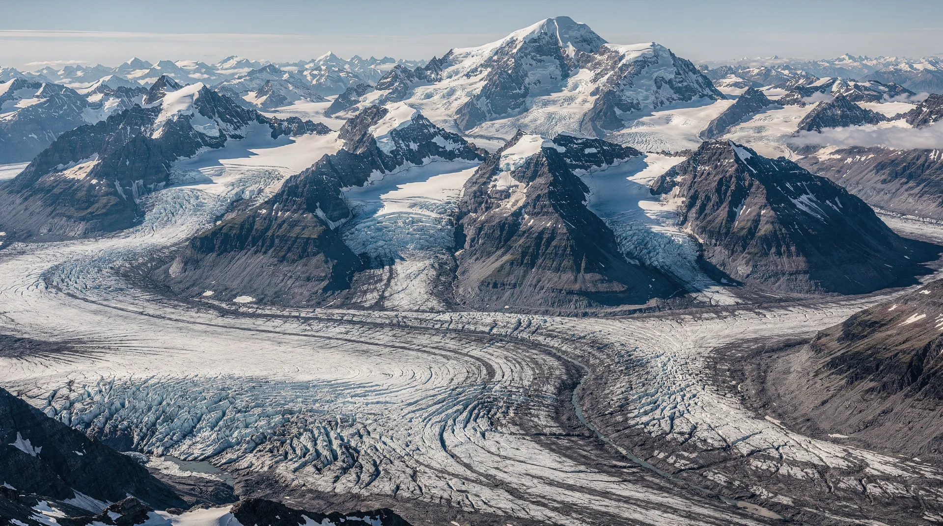
The icefields that fill the mountain interior are the legacy of this height and the corresponding precipitation delivered by Pacific storm tracks. The Kluane Icefields produce dozens of valley glaciers, the largest of which — the Hubbard, Lowell, Walsh, and Kaskawulsh — are among the longest temperate glaciers in the world. The Kaskawulsh Glacier is 70 kilometres long; the Lowell Glacier dams a glacial lake that has periodically burst in catastrophic floods. These are not remnant glaciers clinging to mountain flanks — they are living icefields of continental dimension.
The Dall sheep population that inhabits the park’s front range mountains is one of the reasons Kluane originally received protection. The Kluane region has supported subsistence hunting by Champagne and Aishihik First Nations people for thousands of years; the park’s establishment required long negotiation and is now managed in partnership with the Champagne and Aishihik First Nations and the Kluane First Nation, whose traditional territory encompasses the park.
Top things to do in Kluane National Park
Flightseeing over the icefields
The single most extraordinary experience available to Kluane visitors is a small aircraft flightseeing tour over the icefields and glaciers. From Haines Junction, operators fly ski-equipped Cessna aircraft and larger planes over the Kaskawulsh Glacier and into the heart of the Kluane Icefields, providing views of a frozen world of crevassed ice, nunataks (rock peaks emerging from the glacier), and the towering walls of the Saint Elias peaks. The scale visible from the air cannot be grasped from the ground — glaciers that appear as thin ribbons on maps are kilometres wide; icefields that look manageable on paper extend to the horizon.
Tours range from 45 minutes (Kaskawulsh overview) to 3-hour glacier landing expeditions that allow passengers to step out onto the glacier surface. Glacier landing tours require advance booking months ahead. The two main operators are Icefield Discovery (Haines Junction) and Trans North Helicopters. Weather cancellations are common; build flexibility into your itinerary.
Browse flightseeing and wilderness adventure tours from WhitehorseHike to the Kaskawulsh Glacier viewpoint
The Slims River West Trail leads to the Kaskawulsh Glacier viewpoint, the most accessible glacier vista reachable on foot from the park highway. The trail begins at the Tachal Dhal (Sheep Mountain) visitor centre on the Alaska Highway and climbs steadily through alpine meadows, following the old Slims River valley — dramatically altered when the Kaskawulsh Glacier retreated and diverted its meltwater drainage in 2016, one of the most dramatic observed effects of glacial retreat anywhere in the world.
The viewpoint hike is approximately 15 km return to the glacier viewpoint at the valley head, gaining about 500 metres of elevation. The view across the outwash plain to the glacier’s blue-white terminus, backed by the ice-draped Saint Elias peaks, is remarkable. Allow 6-8 hours for the full return trip.
Watch Dall sheep on Sheep Mountain
The Tachal Dhal (Sheep Mountain) interpretive area, immediately adjacent to the Alaska Highway at the park’s eastern boundary, is one of the most reliable wildlife viewing spots in the Yukon. A resident population of Dall sheep — white wild sheep with curved amber horns — inhabits the mountain slopes year-round. In spring (May-June) and fall (September), ewes and lambs are particularly visible on the lower slopes. Spotting scopes are available at the visitor centre.
The Soldier’s Summit Trail (1.5 km return, easy) climbs to a historic viewpoint above the Alaska Highway where the original road was officially opened in 1942 — an interpretive panel describes the wartime construction of the highway. Views across Kluane Lake are exceptional from the summit. A longer hike continues above into prime Dall sheep habitat.
Find Yukon wilderness and wildlife experiencesHike the Auriol Trail
The Auriol Trail (15 km loop, moderate-strenuous) begins near Haines Junction and climbs through boreal forest and subalpine meadows to an alpine ridge with panoramic views of the Kluane front ranges, the Alsek-Tatshenshini watershed, and on clear days, the beginnings of the glaciated interior. The loop traverses wildflower meadows — particularly vibrant in July — and provides the best day hiking terrain in the park’s front country. Grizzly bear encounters are possible; carry bear spray.
Paddle Kluane Lake
Kluane Lake, along the park’s eastern boundary on the Alaska Highway, is the largest lake entirely within the Yukon and one of the most scenically spectacular lakes in Canada, backed by the snowy front ranges of the Saint Elias. Kayaking or canoeing the lake provides water-level perspectives on the mountains and opportunities for camping on undeveloped shorelines. The lake is subject to strong afternoon winds and can develop dangerous waves quickly — paddle early and be off the water before early afternoon. Boat launches at Destruction Bay and Burwash Landing.
Aurora viewing
Kluane’s remote location, minimal light pollution, and latitude (roughly 61°N) make it an outstanding aurora borealis destination. The aurora season runs from late August through April; the peak months for both darkness and geomagnetic activity are September-October and February-March. The open tundra along the Alaska Highway near the park provides unobstructed northern sky views. The aurora prediction app Glendale or Space Weather Canada can provide short-term forecasts.
Best hikes and trails
Slims River West to Kaskawulsh Glacier viewpoint — 15 km return, moderate. The park’s signature hiking destination. Dramatic outwash plain and glacier views. Allow 6-8 hours.
Auriol Trail — 15 km loop, moderate-strenuous. Best front-country loop hike in the park. Alpine meadows, ridge views, and good grizzly habitat. Allow full day.
King’s Throne Trail — 10 km return, strenuous. Steep climb through spectacular alpine terrain near Kathleen Lake to a bowl above the treeline. The peak rises above for experienced scramblers.
St. Elias Lake Trail — 10 km return, easy-moderate. Through boreal forest to a turquoise mountain lake below the front ranges. Good for families with older children.
Rock Glacier Trail — 1 km, easy. Short interpretive walk near Haines Junction to an active rock glacier — a slow-moving mass of ice-cemented rock debris. Excellent for geological interpretation.
Soldier’s Summit Trail — 1.5 km return, easy. Historic viewpoint over Kluane Lake with interpretive panels on the Alaska Highway’s wartime construction.
Wildlife you might see
Kluane supports one of the highest grizzly bear densities in Canada. The front range mountains and valley bottoms provide critical habitat; bears are visible most reliably in spring (May-June) on south-facing slopes as they emerge from hibernation, and in late summer (August-September) feeding on berries and ground squirrels above treeline. Grizzly encounters on the park’s hiking trails are not uncommon — carry bear spray and travel in groups.
Dall sheep are the park’s most consistently visible large mammal, particularly on the slopes of Tachal Dhal (Sheep Mountain) throughout the year. The rams’ dramatic curved horns are visible at a distance with binoculars from the Alaska Highway. Mountain goats inhabit the steepest cliff terrain in the interior.
Wolves are present throughout the park; the eastern valleys support several packs. Wolf sightings along the Alaska Highway, though not guaranteed, occur regularly — early morning driving is most productive. Moose inhabit the boreal forest zone along the park’s eastern boundary. Wolverine, lynx, and red fox are present but rarely encountered.
The park’s bird list includes golden eagles, rough-legged hawks, and gyrfalcons in the alpine zone. The boreal forest holds woodland caribou, American dippers in the rivers, and a variety of northern owl species including the great grey owl and northern hawk owl.
Getting there
Kluane National Park is located in the southwestern Yukon, accessible via the Alaska Highway (Highway 1). The main park community of Haines Junction is 158 km west of Whitehorse and 480 km east of Anchorage, Alaska.
Whitehorse Erik Nielsen International Airport (YXY) is the regional hub, with daily jet service from Vancouver, Calgary, and Edmonton, plus seasonal connections to other cities. Car rental is available at the Whitehorse airport; the drive to Haines Junction on the Alaska Highway takes approximately 1.5-2 hours.
There is no public transit to or within the park. A car is essential. RV travel is popular on the Alaska Highway — numerous RV parks line the highway through the Kluane area.
Where to stay
Haines Junction is the main park service centre, with a handful of motels, B&Bs, a small grocery store, and the Kluane National Park visitor centre. Accommodation is limited — book well in advance for July and August. The Da Ku Cultural Centre (Champagne and Aishihik First Nations) in Haines Junction is worth visiting.
Kathleen Lake Campground (26 km south of Haines Junction on Highway 3) is Parks Canada’s campground within the park, with tent and RV sites in a spectacular mountain lake setting. Reservations recommended for peak season.
Along the Alaska Highway: Several small lodges and RV parks operate at Destruction Bay and Burwash Landing on Kluane Lake, providing basic accommodation.
Whitehorse (158 km east) provides the full range of urban accommodation and is the base for travellers building a multi-day Yukon itinerary around the park.
Best time to visit
July and August are the warmest months (highs of 16-20°C at valley elevations) and the most reliable for hiking and flightseeing. Wildflowers peak in mid-July in the alpine meadows. Mosquitoes are active through July; bug protection is essential.
June has very long days (nearly 20 hours of daylight near the solstice) and good wildflower and wildlife activity. Some high-elevation snow lingers on trails; check current conditions.
September is excellent for hikers: the tundra turns brilliant red and orange, crowds thin, and the first aurora displays of the season appear as nights darken. Grizzly bears are highly active feeding before denning. Snow can arrive at higher elevations from mid-September onward.
Winter (October–April): The park is accessible for cross-country skiing and snowshoeing from the Haines Junction area. The aurora season is at its peak from September through March. Temperatures can be extreme (−30°C or below in deep winter). The Alaska Highway remains open year-round.
Practical info
Park entry fee (2026): Adult CA$10.50/day, family/group CA$21.00/day. The Parks Canada Discovery Pass covers all national parks for 12 months. Backcountry permits required for overnight wilderness travel.
Bear safety: Mandatory in this park. Carry bear spray at all times on trails and in the backcountry. Make noise when hiking in dense vegetation. Store food in approved bear canisters or hang bags in backcountry camps. The park staff can provide detailed bear safety briefings.
Flightseeing booking: Book glacier tours 2-4 months in advance for summer. Weather cancellations occur frequently; confirm with operators the morning of your tour. Glacier landing tours require more advance planning and physical fitness for walking on glacier terrain.
Cell coverage: Very limited. Coverage exists in Haines Junction; none in the park backcountry or on trail. Satellite communication devices (PLBs or SPOT devices) are strongly recommended for backcountry travel.
Frequently asked questions about Kluane National Park guide: Yukon’s Mount Logan and Kaskawulsh Glacier
Can I see the glaciers without a flight?
The Kaskawulsh Glacier viewpoint is reachable on foot via the Slims River West Trail (15 km return). This provides a spectacular ground-level view of the glacier terminus and outwash plain. However, the vast majority of the Kluane icefields — including the most dramatic glacier systems and the high peaks — are accessible only by small aircraft. A flightseeing tour, even a short one, is the experience that makes the true scale of Kluane comprehensible.
How dangerous is grizzly bear country in Kluane?
Kluane has a high grizzly bear density, and encounters on trails do occur. The risk of a dangerous encounter is real but manageable with proper precautions: carry bear spray and know how to use it, make noise while hiking, travel in groups of three or more, and follow Parks Canada protocols for food storage at campsites. The park visitor centre provides a comprehensive bear safety briefing that all backcountry visitors should attend before heading into the field.
Is Mount Logan accessible to regular hikers?
No. Mount Logan requires a serious mountaineering expedition with technical skills, high-altitude experience, and logistical support. The standard route involves flying to a base camp at altitude and acclimatising over several weeks. It is one of the most challenging major peaks in North America — the summit plateau is larger than the country of Switzerland, and extreme cold, high altitude, and rapidly changing weather make it a demanding objective even for highly experienced mountaineers.
What is the best time for the Northern Lights?
Aurora activity is possible from late August through April. The best combination of darkness (longer nights) and geomagnetic activity occurs in September-October and February-March. The solstice months (November-January) have the longest nights and can produce exceptional displays, but temperatures are extreme. Check the aurora forecast from Space Weather Canada and plan to be outdoors on clear nights — even a brief display at Kluane is memorable in the context of the mountain silhouettes.
How far is Kluane from Whitehorse?
Haines Junction, the main park gateway, is 158 km from Whitehorse on the Alaska Highway — about 1.5-2 hours’ drive. The full length of the park along the Alaska Highway is approximately 160 km from Haines Junction north to the park boundary near the Alaska border crossing at Beaver Creek.
Is there road access into the park interior?
No paved roads enter the park interior. The Alaska Highway runs along the eastern boundary, and the only other paved road is the short stretch to Kathleen Lake Campground on Highway 3 south of Haines Junction. A few gravel tracks provide limited access, but the vast majority of the park interior is roadless wilderness accessible only by aircraft or on foot.