Garibaldi Lake trail: the ultimate hike guide
How hard is the Garibaldi Lake trail?
The Garibaldi Lake trail is a moderate-to-strenuous 18 km return hike with 820 m of elevation gain. Most fit hikers complete it in 5–7 hours return. The trail is well-maintained but relentlessly uphill on the way in. Day hiking and overnight camping are both popular options.
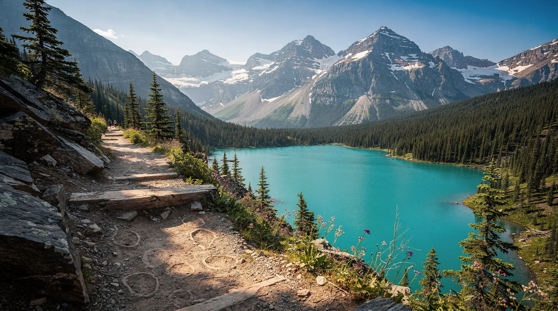
Garibaldi Lake is the kind of place that makes you question whether a colour that vivid can exist in nature without some editorial assistance. It can, and it does — the lake’s impossible turquoise comes from glacial flour suspended in the water, mineral particles ground fine by the Sphinx Glacier above, which tints the light in a way that no filter quite replicates. The lake sits at 1,470 metres in Garibaldi Provincial Park, ringed by volcanic peaks, ancient lava flows, and the kind of silence that only arrives when you are genuinely far from anything mechanical.
The Garibaldi Lake trail is the most popular hike in British Columbia’s southwestern mainland and consistently ranks among the top day hikes in Canada. It is not a casual stroll — 820 metres of elevation gain across 9 kilometres makes it a genuine workout — but it is well within reach of anyone who hikes regularly and is prepared for the climb. The reward at the top is among the finest views in the province.
Trail basics
Trailhead: Diamond Head Road trailhead off Highway 99, 2.5 km north of Squamish at the Black Tusk/Garibaldi Lake junction. The access road is approximately 10 km long.
Distance: 18 km return (to Garibaldi Lake). Add 2 km return for the side trip to Panorama Ridge junction, or extend to Black Tusk (another 8 km return from the campsite).
Elevation gain: 820 m (trailhead to lake)
Typical time: 5–7 hours return as a day hike. Overnight trips allow you to explore the broader area including Taylor Meadows and the Black Tusk.
Trail surface: Well-maintained forest trail with switchbacks, transitioning to subalpine terrain near the top. Rocky in sections near the lake shore. Snow lingers on upper sections until late June or early July in most years.
Signage: Good throughout. The junction for Garibaldi Lake versus Taylor Meadows is clearly marked about 8 km in.
Getting there
The trailhead is approximately 75 km north of Vancouver on Highway 99 (the Sea-to-Sky Highway), or about 37 km south of Whistler. From Squamish, the turn onto Diamond Head Road is signed. The access road is paved but narrow, with a large parking area at the end.
Parking: The trailhead lot fills by 7 am on summer weekends. BC Parks introduced a mandatory day-use parking reservation system that applies from late June through September. Check the BC Parks reservation portal well in advance. Alternatively, take the Squamish-Whistler transit connection from Vancouver and walk or hitch to the trailhead — parking reservations are not required if you arrive by transit.
Transit option: The Highway 99 corridor has limited transit, but Squamish Transit connects with BC Transit services from Vancouver. The trailhead itself is not served by transit, but the Highway 99 junction is within cycling or ridesharing distance.
The trail in detail
Section 1: Trailhead to Barrier Lake junction (4 km, 400 m gain)
The trail begins in a Douglas fir and hemlock forest and climbs steadily through a series of long switchbacks. This section is the psychological crux for many hikers — the forest provides little view, and the climbing feels relentless. Pace yourself here. The trail is wide and well-graded, and you will pass a small creek crossing at around 2.5 km that offers a good water stop.
At approximately 4 km, you reach the junction for Barrier Lake. The small lake is a short side trip and worth it on the way back if legs allow, but skip it on the way up and save energy for the main objective.
Section 2: Barrier Lake junction to the lake (5 km, 420 m gain)
The second half of the climb transitions from dense forest into subalpine terrain, with increasing views of the surrounding peaks. You pass through stands of subalpine fir, cross several small streams (all safe to drink with treatment), and begin to see the volcanic landscape that characterises Garibaldi Park — strange, dark lava formations interspersed with wildflower meadows.
The final approach to the lake crosses a section of scree before the trail flattens onto the lake shore. Your first view of the turquoise water, with the Sphinx Glacier and Mount Garibaldi rising above, is the defining image of this hike.
At the lake
The camping area and shelter are at the north end of the lake. The lake shore walk between the camping area and the far end is approximately 2 km and is extraordinary — the colour of the water changes constantly with the angle of the light, from pale aquamarine in shadow to a deep, saturated teal in full sun.
Garibaldi Lake is cold year-round (typically 8–12°C in summer) but swimming is possible and popular near the camping beach. A short trail climbs to Panorama Ridge (add 4 km and 400 m return from the camping area), where the view extends across the lake to Opal Cone, the Cinder Cone, and the Black Tusk — one of the finest panoramas in BC.
Camping at Garibaldi Lake
The Garibaldi Lake campsite has approximately 40 tent pads, food storage caches (bear boxes), picnic tables, and pit toilets. The BC Parks reservation system handles all backcountry bookings and reservations are mandatory from mid-June through mid-September. Bookings open in January for the following season and the most popular dates sell out within hours.
Fees are approximately CAD 10–15 per person per night (subject to annual adjustment). Camping outside designated pads is not permitted — the lake’s fragile subalpine ecosystem cannot absorb dispersed camping pressure given the visitor numbers.
Taylor Meadows campsite is an alternative at approximately 7 km from the trailhead, with similar facilities and views toward the Black Tusk rather than the lake directly. It books out equally fast.
Best time to visit
Late June–July: Snow may still cover portions of the upper trail into early July in heavy snow years. Wildflowers are at peak. Mosquitoes are significant (bring repellent). Days are long — sunrise around 5:15 am, sunset after 9 pm.
August: Optimal conditions. Snow-free trail, warm temperatures (15–22°C at the lake on good days), settled weather patterns, and wildflowers still present. Busiest month of the year.
September: Excellent. Crowds thin after Labour Day, temperatures cool (8–15°C at the lake), and fall colour begins in the subalpine meadows. Snow can arrive any time after mid-September, so check conditions.
October onward: The trail can receive significant snowfall by October. Crampons or microspikes are advisable from mid-October. The park does not close, but conditions become genuinely challenging and navigation skills matter more.
Wildlife
Garibaldi Provincial Park hosts black bears (common on and near the trail — make noise and follow BC Parks bear protocols), marmots (frequently seen and heard in the rocky subalpine terrain), pikas (small mammals that whistle from talus slopes — listen for them on the upper trail), golden eagles and various raptors, and abundant birds in the forest sections. The lake itself has no fish — it was not stocked and the native ecosystem is invertebrate-based.
What to pack
Day hiking essentials:
- 2+ litres of water (fill at streams with a filter; do not drink unfiltered)
- High-energy food for 6–8 hours of activity
- Waterproof jacket (weather can change in 30 minutes)
- Warm mid-layer (temperature at the lake is 10–15°C cooler than Vancouver)
- Sunscreen, sunglasses, hat
- Trekking poles (helpful for the descent)
- First aid kit
- Headlamp (if starting before dawn or timing could push sunset)
- Trail map or downloaded GPS track
Additional for overnight:
- Tent rated to 0°C (temperature can drop sharply even in August)
- Sleeping bag rated for subalpine temps
- Camp stove and fuel
- Food in a bear canister or for the on-site bear boxes
- Trowel for cat-hole burial if going beyond the campsite
Booking guided hiking tours
For visitors who want professional guidance, naturalist knowledge, or a group experience without the logistics, guided day hikes to Garibaldi Lake operate from both Vancouver and Squamish throughout summer.
Browse guided hiking tours from Vancouver to Garibaldi Lake and the Sea-to-Sky corridorCosts
| Item | Cost (CAD) |
|---|---|
| Parking reservation | $10–16/day |
| Backcountry camping | $10–15/person/night |
| Guided day hike from Vancouver | $95–175/person |
| Water filter (purchase) | $35–90 |
Safety
The Garibaldi Lake trail is well-maintained but it is a genuine backcountry environment. Cell reception is intermittent above the trailhead. Inform someone of your plans and expected return time. The biggest risks are weather changes (afternoon thunderstorms in July–August), bear encounters (follow protocols), and exhaustion on the return descent — many rescues occur on the descent when hikers have depleted their energy reserves on the climb.
Emergency: BC Search and Rescue is activated via 911. The Emergency SOS feature on modern iPhones and Android devices with satellite connectivity is increasingly useful in this area.
Where to stay nearby
Squamish: Sea to Sky Hotel, Howe Sound Inn, Alice Lake campgrounds. Squamish is 37 km south of the trailhead and makes the most logical base for a day hike or for the night before an overnight trip.
Whistler: For those combining Garibaldi with Whistler activities — see the Whistler accommodation guide for options 37 km north of the trailhead.
Camping at the trailhead: There is no formal camping at the trailhead. Alice Lake Provincial Park (15 km south in Squamish) has the nearest campground.
Nearby trails and extensions
From the Garibaldi Lake camp, you can extend your trip significantly:
- Black Tusk (8 km return from camp, 600 m gain): The iconic volcanic pinnacle visible from much of the Sea-to-Sky corridor. The upper section involves scrambling on loose volcanic rock and basic route-finding. Highly recommended for confident hikers.
- Panorama Ridge (4 km return from camp, 400 m gain): The finest viewpoint in the park, with the full lake visible below and the volcanic peaks surrounding it.
- Helm Creek (multi-day traverse): Trail connects to Cheakamus Lake on the north side of the park, creating a possible 2–3 day traverse with vehicle shuttle.
Related guides
If you enjoyed the Garibaldi Lake trail, the Joffre Lakes trail guide covers a similarly spectacular glacial lake hike about an hour north toward Pemberton. The Stawamus Chief hike guide covers the iconic summit hike directly above Squamish. For a broader overview of BC hiking options, see the best hikes in British Columbia guide.
Explore Whistler and Sea-to-Sky outdoor tours and activitiesFrequently asked questions about Garibaldi Lake trail: the ultimate hike guide
Do I need a permit to hike Garibaldi Lake?
You do not need a permit for day hiking, but you do need a parking reservation if driving to the trailhead during the reservation period (typically late June to mid-September). For overnight camping, a backcountry reservation through BC Parks is mandatory during the same period.
Can I swim in Garibaldi Lake?
Yes. The water is cold (typically 8–12°C in summer) but swimming is popular, especially near the campsite beach. Do not use soap or sunscreen in or near the lake.
Is the Garibaldi Lake trail suitable for children?
The trail is long and steep for young children. Kids aged 10 and up who hike regularly can complete it, though the 9 km climb will be tiring. Ages 12 and above are a more realistic starting point for most children. The trail has no technical sections and is safe for competent young hikers.
Are dogs allowed on the Garibaldi Lake trail?
Dogs are allowed on the trail but must be on-leash at all times in Garibaldi Provincial Park. Clean up after your dog and be aware that wildlife encounters (bears, marmots) are common.
What is the elevation at Garibaldi Lake?
The lake sits at 1,470 metres above sea level. The trailhead is at approximately 650 metres, giving a total elevation gain of 820 metres.