Duffey Lake Road: Whistler to Lillooet's most scenic drive
How long does the Duffey Lake Road drive take?
The Duffey Lake Road (Highway 99) from Whistler to Lillooet is approximately 130 km and takes 2–2.5 hours of driving without stops. With stops at Joffre Lakes, Duffey Lake, and Seton Lake viewpoints, allow 4–6 hours. The road is paved but narrow and winding — not a fast drive.
The Duffey Lake Road is the stretch of Highway 99 that connects Whistler to Lillooet through the mountains east of Pemberton — a 130-kilometre drive that contains more dramatic scenery per kilometre than almost any other paved road in Canada. In roughly two hours of driving (much longer with stops), the road climbs from the Whistler Valley through the glaciated peaks of the Cayoosh Range, passes turquoise glacial lakes, crosses a high alpine summit, and then descends in breathtaking canyon switchbacks into the dry canyon country of the Fraser Plateau, arriving at Lillooet in a landscape that bears no resemblance whatsoever to where you started.
The transition is staggering. Begin in the forests and mountain streams of the Coast Mountains — green, wet, perpetually misty. End in a semi-arid canyon above the Fraser River — dry, dramatic, hot in summer, the gold rush’s primary artery in 1858 and still capable of feeling remote.
The Duffey Lake Road is also one of BC’s most reliably closed-for-avalanche roads in winter. Plan accordingly.
The route
Start point: Whistler (or Pemberton, 35 km north of Whistler)
End point: Lillooet
Distance: Approximately 130 km from Whistler; 95 km from Pemberton
Elevation range: 200 m (Pemberton) to 1,533 m (summit)
Driving time: 2–2.5 hours (no stops, Whistler to Lillooet)
Road type: Paved, two lanes, many sharp curves, steep grades
Joffre Lakes Provincial Park
The most significant stop on the Duffey Lake Road, 25 km east of Pemberton. Joffre Lakes is the trail to three glacial turquoise lakes, the upper of which sits at the foot of the Matier Glacier — one of the finest short hikes in BC. If you drive the Duffey without stopping at Joffre Lakes, you have missed the most accessible and dramatic feature of the route.
Parking requires a day-use reservation in summer (June–September). See the full Joffre Lakes trail guide for details on the hike itself, parking logistics, and what to expect.
Allow 3.5–5 hours for Joffre Lakes (including the hike to the upper lake), then continue east on the Duffey.
From Joffre Lakes to the summit
East of Joffre Lakes, the road begins climbing in earnest. The vegetation changes as elevation increases — Douglas fir transitions to subalpine fir, and by the time you approach the pass, the landscape opens into rocky subalpine terrain with expansive views back toward the Joffre Lakes valley.
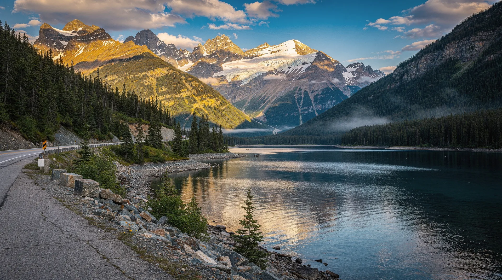
Duffey Lake appears on the left side of the road approximately 45 km east of Pemberton — a long, deep glacial lake cradled between steep forested slopes. A small BC Recreation Site (no services) provides rough camping and a boat launch. The lake is cold and not ideal for swimming, but the turquoise colour and mountain backdrop make it worth a 10-minute stop for photographs.
The summit (1,533 m) is reached approximately 55 km east of Pemberton. There is a small pull-out at the top of the pass with views east toward the Cayoosh Range. In early season (May–June), snow may still be visible on the surrounding peaks; in August, the subalpine meadows are in flower.
The descent to Lillooet
The descent from the summit to Lillooet is the most dramatic section of the Duffey Lake Road. The road drops 1,300 metres in approximately 35 kilometres through a series of switchbacks and steep grades that reveal increasingly arid landscape — you are now in the rain shadow of the Coast Mountains, receiving a fraction of the precipitation that falls on the Whistler side.
Cayoosh Creek canyon is the main feature of the descent — a narrow canyon carved by the creek through the mountains, with the road clinging to the cliff walls. Pull-outs allow stopping to absorb the scale. The canyon narrows significantly in places, with rock walls rising directly above the road.
Seton Lake appears below Lillooet — a long, intensely turquoise lake in the canyon country. The turquoise colour is caused by glacial silt carried in from the Carpenter Lake reservoir system. The lake’s colour is, in some lighting conditions, even more vivid than Joffre Lakes. A viewpoint above the lake on the descent provides one of the finest panoramas on the entire route.
Lillooet
Lillooet (population approximately 2,500) is a historic Gold Rush town at the junction of the Duffey Lake Road and Highway 12. The town was Mile Zero of the Douglas Road during the 1858 Cariboo Gold Rush — the starting point for miners heading north into the BC interior.
Today Lillooet has a small but growing tourism presence centred on its history (the Lillooet Museum), the Fraser River and its fish populations, and the surrounding landscape. The town is noticeably hotter and drier than the Whistler side — summer temperatures regularly exceed 35°C, a contrast to the alpine cool of the Duffey summit 35 km west.
Fraser River: Lillooet sits at the confluence of the Cayoosh Creek and the Fraser River. The Fraser here is a wide, powerful, turbid flow — nothing like the clear mountain streams of the Coast Mountains. The Indigenous heritage of this Fraser River section is profound — Lillooet has been inhabited by the St’át’imc (Lillooet) people for thousands of years, with fish camps and cultural sites throughout the canyon.
Circuit options from Lillooet:
- Continue north on Highway 99 to Cache Creek, then return to Vancouver via the Trans-Canada (total loop approximately 7–8 hours)
- Return via Highway 12 along the Fraser River to Lytton, then Highway 1 back to Vancouver (slightly longer but the canyon drive on Highway 12 is excellent)
- Continue north toward 100 Mile House and the Cariboo
Best season for the Duffey Lake Road
May–June: Snow typically clears from the summit by mid-May in a normal snow year. June brings wildflowers at Joffre Lakes and manageable crowds. Check avalanche and road condition reports before going in May.
July–August: Peak season. Road is fully clear, Joffre Lakes is snow-free, and the drive is at its best. Parking at Joffre Lakes requires an advance reservation.
September–October: Excellent. Fall colour begins in early October in the subalpine zones. Cooler temperatures and smaller crowds make September particularly appealing.
November–April: The Duffey Lake Road is one of BC’s most avalanche-prone highway segments. It is regularly closed for avalanche control and occasionally for extended periods after major snowfall events. Check DriveBC.ca for current road status before any winter travel. Winter driving on the Duffey requires snow tires (mandatory in BC November 1–April 30 on designated highways) and experience with mountain driving.
Road and driving tips
Snow tires: Required in winter (BC regulation). Even in shoulder season (May, October), snow can be present near the summit. Check conditions.
Fuel: Fill up in Whistler or Pemberton before heading east. There is no fuel available between Pemberton and Lillooet on the Duffey Lake Road itself.
Cell coverage: Limited to no coverage for most of the Duffey Lake Road between Pemberton and Lillooet. Download maps offline before departing.
RV access: The Duffey Lake Road is manageable for standard passenger vehicles and smaller RVs (under 8 metres). Large RVs and trucks with trailers should take alternate routes — the steep grades and sharp switchbacks are not suitable for large vehicles.
Two-way traffic on narrow sections: The road is two lanes throughout but becomes very narrow in canyon sections. Drive cautiously and yield to uphill traffic at switchbacks.
What to bring
- Full tank of fuel in Pemberton
- Water and food for a day (no services between Pemberton and Lillooet)
- Offline maps (BC Parks or Google Maps downloaded)
- Camera (obviously)
- Layers — temperature drop from Lillooet (35°C in summer) to the summit (10–15°C) is significant
Combining the Duffey with a Whistler visit
The Duffey Lake Road is an excellent half-day or full-day extension of a Whistler stay. From Whistler:
Half day (Joffre Lakes and return): Drive to Joffre Lakes, complete the hike, return to Whistler — 6–8 hours total. Excellent day trip.
Full day (one-way to Lillooet with car shuttle): Arrange to drop a car in Lillooet or use a transfer service, drive the full Duffey, and return via Lytton and the Trans-Canada — a full day but the finest scenic drive loop from Whistler.
Browse Vancouver and Sea-to-Sky tours and road trip experiences on GetYourGuideFrequently asked questions about Duffey Lake Road: Whistler to Lillooet’s most scenic drive
Is the Duffey Lake Road dangerous?
The Duffey is a mountain highway with steep grades and sharp curves — it requires attentive driving. It is not inherently dangerous for experienced mountain drivers in good conditions. The winter avalanche risk is real and taken seriously by BC transportation — when the road is closed for avalanche control, do not try to access it. In summer, the primary hazards are speed (don’t rush the corners), distracted driving (the views demand pulling over, not rubbernecking while driving), and the occasional rock from canyon walls.
Can I drive the Duffey in a regular car?
Yes, in summer. All-wheel drive or four-wheel drive is not required in summer conditions. In winter or spring shoulder season with possible snow on the upper section, winter tires and AWD/4WD are advisable.
Is the road open year-round?
Officially yes, but practically not always. The Duffey is closed for avalanche control multiple times per winter and occasionally for extended periods after major storms. Check DriveBC.ca (or the Drive BC app) before every winter or shoulder-season trip.
What is the altitude sickness risk?
The summit at 1,533 metres is not high enough to cause altitude sickness in healthy individuals. Mild headache from rapid elevation gain is possible; drink water and take the ascent at the posted speed limits. People with severe cardiovascular or respiratory conditions should consult a doctor before extended time at altitude.