Crowsnest Highway: BC's south border scenic drive
How long is the Crowsnest Highway drive?
The Crowsnest Highway (BC portion of Hwy 3) runs 840 km from Hope to the Alberta border at Crowsnest Pass. Driving time is 10-12 hours without stops. Most travellers take 3-5 days to explore properly, breaking the journey at Manning Park, Osoyoos, Nelson, and Fernie.
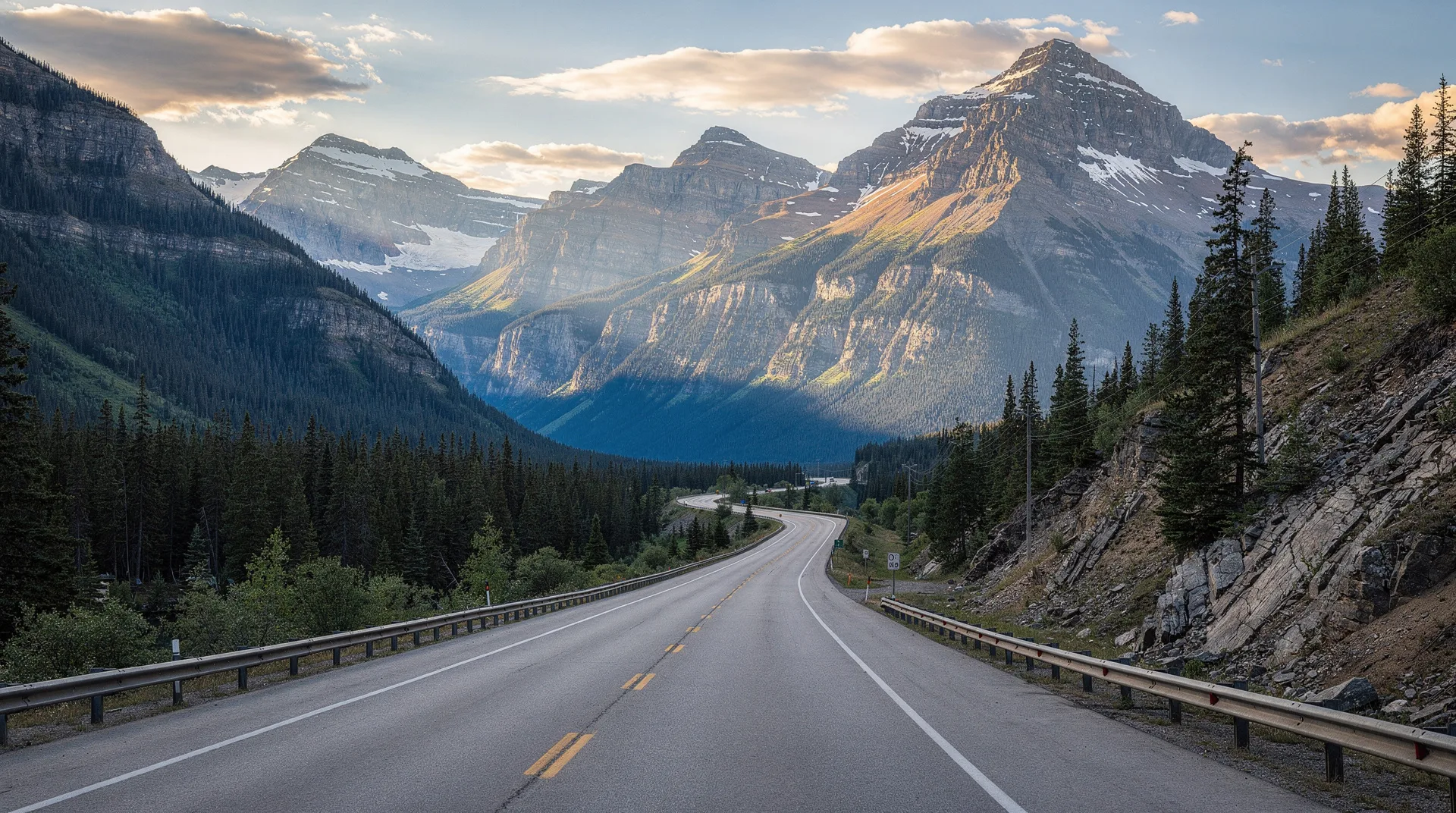
The Crowsnest Highway — BC’s section of Highway 3 — is the province’s most underappreciated scenic drive. It runs for 840 km along BC’s southern tier, from Hope near Vancouver east to the Alberta border at the Crowsnest Pass. Along the way it crosses four distinct mountain ranges, passes through Canada’s only desert, touches Canada’s warmest town, threads the mining country of the Kootenays, and ends at the prairies. It is slower, quieter, and more varied than the Trans-Canada to the north — and rewards every extra hour you can give it.
This guide covers the full length of the BC portion, the key stops, logistics, and itinerary suggestions.
The route at a glance
The Crowsnest crosses:
- The Cascades (Manning Park)
- The Similkameen and Okanagan valleys (Keremeos, Osoyoos, the interior dry belt)
- The Monashee Mountains (Anarchist Summit, Christina Lake)
- The Selkirk Mountains (Castlegar, Salmo-Creston summit)
- The Purcell Mountains (Creston, Cranbrook)
- The Rocky Mountains (Fernie, Crowsnest Pass into Alberta)
It touches parts of BC that most travellers miss — the South Okanagan, the Boundary Country, the Creston Valley, the Elk Valley — each with its own character.
Stage 1: Hope to Princeton (136 km, 2 hours)
Beginning in Hope at the Fraser Canyon gateway, Hwy 3 climbs east through E.C. Manning Provincial Park, one of BC’s most accessible wilderness parks. Manning offers:
- Lightning Lake — an easy 9-km loop trail around a classic mountain lake
- Rhododendron Flats — pink blooms in mid-June
- Cascade Lookout — short drive to a panoramic viewpoint
- Gibson Pass — the park’s small ski area
- Manning Park Resort — the one full-service accommodation within the park
Manning makes an excellent first-night stop for travellers with time. Allow 4-6 hours to explore thoroughly.
Princeton, the gateway out of Manning, is a small former-mining town with a good local museum (Princeton Museum and Archives) and the start of the Similkameen Valley.
Stage 2: Princeton to Osoyoos (115 km, 1h 30 min)
The highway follows the Similkameen River through one of BC’s most underrated agricultural valleys.
Keremeos — “Fruit Stand Capital of Canada.” In summer the highway is lined with fruit stands selling cherries, apricots, peaches, plums, nectarines, and apples direct from the orchards. The Grist Mill and Gardens (a 1877 heritage mill) is a worthwhile stop. Nearby Cathedral Provincial Park has outstanding day hikes but requires either a 4x4 or booking the shuttle service to reach the base camp.
Similkameen wineries — The valley has an emerging wine region focused on organic production. Orofino Vineyards and Seven Stones Winery are standouts.
Osoyoos sits at the end of the valley where the Similkameen meets the Okanagan. Canada’s warmest freshwater lake (Osoyoos Lake), genuine desert ecology (the only pocket desert in Canada), and the Nk’Mip Desert Cultural Centre — one of the finest Indigenous-interpreted sites in Canada — make Osoyoos a required stop. Anarchist Summit Lookout east of town provides one of the best viewpoints in the southern Okanagan.
Stage 3: Osoyoos to Castlegar (260 km, 3h 30 min)
Climbing east from Osoyoos, the highway crosses Anarchist Summit (1,233 m) into the Boundary Country — a historical mining and ranching region along the Kettle River.
Grand Forks — a town with strong Doukhobor heritage (Russian Christian pacifist settlers who came to BC in the early 1900s). Borshch House Museum is excellent. The nearby town of Greenwood has heritage architecture from the copper boom.
Christina Lake — one of BC’s warmest swimming lakes, with excellent beaches and family-friendly atmosphere.
Rossland — see the Rossland destination for context. A short detour (15 min) off the main highway. Red Mountain Resort is here.
Castlegar — the Columbia-Kootenay confluence, airport for the West Kootenays, and the turning point for trips to Nelson. The Doukhobor Discovery Centre and Zuckerberg Island (a fascinating small island with Russian Orthodox heritage buildings) are worth stopping for.
Optional detour: Nelson
From Castlegar, most travellers making the full Crowsnest journey detour 40 km north to Nelson — adding at least a full day to properly appreciate BC’s most beloved mountain town. See the Nelson vs Revelstoke comparison for context.
Stage 4: Castlegar to Creston (135 km, 1h 45 min)
Hwy 3 continues east through the Salmo River valley, crossing the Kootenay Pass (Salmo-Creston Summit) at 1,774 metres — the highest point on Highway 3, and occasionally a challenging winter drive.
Salmo — a tiny town with a small downtown scene built around the Salmo River.
Creston — a substantial agricultural town at the south end of the Kootenay River valley. Creston Valley Wildlife Management Area is excellent for birding. The town has a good farmers’ market and is the centre of a significant dairy and orchard region. Creston is also a brewery town — Columbia Brewery (Kokanee Beer) has its main operations here.
Stage 5: Creston to Fernie (220 km, 2h 45 min)
Hwy 3 climbs from Creston across the Purcell Mountains, crossing Kootenay Pass a second time, and descending into the East Kootenays and Elk Valley.
Cranbrook — the commercial centre of the East Kootenays. See the Cranbrook destination page. The Canadian Museum of Rail Travel is outstanding.
Kimberley — a short detour north of Cranbrook; voted BC’s best small town, with a Bavarian-themed pedestrian downtown. See the Kimberley destination page.
Fort Steele — a heritage town between Cranbrook and Fernie, restored to its 1890s condition with living-history interpretation.
Fernie — the iconic mountain town of the Elk Valley. Fernie Alpine Resort (see the BC ski guide), extensive mountain biking, and excellent dining in a heritage downtown. A recommended overnight stop. See the Fernie destination page.
Stage 6: Fernie to Alberta border (70 km, 1 hour)
The final leg climbs through the Elk Valley past several coal-mining communities (Sparwood, Elkford nearby) before ascending the Crowsnest Pass (1,357 m) — the namesake pass that divides BC from Alberta and the Canadian Rockies from the Alberta foothills.
Sparwood — home of the world’s largest truck (a decommissioned mining haul truck displayed in town). A worthwhile photo stop.
The Frank Slide Interpretive Centre (across the border in Alberta) commemorates Canada’s deadliest landslide (1903, 90 million tonnes of rock). Combined with the crossing into Alberta, Crowsnest Pass makes a dramatic exit or entry to the BC Rockies.
Driving times and logistics
Direct drive (no stops): 10-12 hours for the full 840 km. Not recommended — you miss everything.
3-day itinerary: Hope to Osoyoos (day 1), Osoyoos to Nelson (day 2), Nelson to Fernie/Alberta (day 3). Tight but covers the highlights.
5-day itinerary: Add Manning Park (extra night at Manning Park Resort) and a day in Nelson.
7-10 day itinerary: The proper Kootenays-inclusive version. Add Nelson (2 nights), Kaslo/Ainsworth Hot Springs (1 night), and Fernie (2 nights) for thorough exploration.
Gas, accommodation, and services
Services are plentiful throughout the BC portion of Hwy 3 — unlike the Cassiar or other northern BC highways, you are never more than 30-60 minutes from fuel and food. Most towns have mid-range accommodation; resort-quality lodging is concentrated at Osoyoos, Christina Lake, Nelson (short detour), and Fernie.
Winter driving
Hwy 3 crosses four mountain passes in BC, each with significant winter weather potential. Winter tires are legally required on Hwy 3 between October 1 and April 30. Check DriveBC.ca for road conditions before and during travel. Avalanche closures on Kootenay Pass are occasionally necessary in severe storms.
Connecting with other BC road trips
The Crowsnest pairs naturally with:
- The Icefields Parkway and Banff via Alberta — drive north from Crowsnest Pass to Calgary, then west to Banff and into the BC Rockies
- The Okanagan wine country — detour north from Osoyoos into the Okanagan Valley
- Vancouver Island — tie the western end at Hope into a ferry crossing from Vancouver
- The Kootenay loop — Nelson + Kaslo + Revelstoke (see the Nelson vs Revelstoke guide)
Frequently asked questions about Crowsnest Highway: BC’s south border scenic drive
Is the Crowsnest Highway or Trans-Canada Highway better?
Different experiences. The Trans-Canada is faster (6-7 hours Hope to Alberta) and hits Kamloops, Revelstoke, Rogers Pass, and Lake Louise. The Crowsnest is slower (10-12 hours) and hits Manning Park, Osoyoos, Boundary Country, Nelson/Castlegar, Creston, and Fernie. For scenery variety and fewer crowds, the Crowsnest wins.
How long does the Crowsnest Highway take?
Three days is the minimum to appreciate. Five to seven days is ideal. The 840 km drive covers four mountain ranges and six distinct regions — it rewards time.
Is the Crowsnest Highway open in winter?
Yes, year-round. But all four mountain passes can be challenging in winter storms. Winter tires are legally required October 1 to April 30. Avalanche closures on Kootenay Pass occasionally occur.
What is the best season for the Crowsnest Highway?
June-September for full enjoyment — open roads, blooming flowers, warm weather, everything accessible. September is particularly excellent with fall colours, harvest in the Okanagan and Creston, and thinner crowds. Winter works for travellers specifically seeking skiing.
Can I drive the Crowsnest without a car rental?
The bus network along Hwy 3 is limited. Ebus and similar operators run between some larger towns, but coverage is patchy. For the full Crowsnest experience, a rental car is essentially required.
Where should I stop for the night?
Classic overnight stops: Manning Park Resort (day 1), Osoyoos (day 2), Nelson if detouring (day 3-4), Fernie (final night before Alberta). All have solid accommodation.