Quick facts
- Located in
- Thompson-Okanagan (north)
- Best time
- June to September (hiking & paddling); October (colour)
- Getting there
- 2 hrs north of Kamloops via Hwy 5 to Clearwater
- Days needed
- 2-5 days
Wells Gray Provincial Park is British Columbia’s fourth-largest provincial park — 540,000 hectares of volcanic plateau, old-growth forest, glacier-fed lakes, and a concentration of waterfalls that is unmatched in Canada. The park has been called “Canada’s Waterfall Park” informally for decades, a tag it earns: within a few hours’ drive of the park entrance at Clearwater, visitors encounter Helmcken Falls (the fourth-highest waterfall in Canada), Dawson Falls, Spahats Falls, Moul Falls, and dozens of lesser-known cascades dropping from volcanic canyon walls into the Clearwater and Murtle Rivers.
The park is not small or cosmetically wild — this is genuine wilderness. The Murtle River and the lake chain it connects are accessible only by float plane or a 24-kilometre hike in, ensuring that the backcountry remains as remote as it was before the park’s designation in 1939. Black bears are common throughout the park, moose wade in the shallow lakes throughout the summer, woodland caribou move through the northern reaches, and wolves are present but rarely seen. The Clearwater River corridor — the main access spine — gives visitors a front-country experience of real quality while the park’s interior remains one of BC’s least-visited wilderness areas.
Helmcken Falls
Helmcken Falls drops 141 metres into the Murtle River canyon — a single unbroken plunge that makes it the fourth-highest waterfall in Canada and, in terms of water volume combined with height, one of the most spectacular in the country. The viewpoint above the falls is 3 kilometres from the main park road — a flat, easy walk on a well-maintained trail through old-growth forest.
The scale of Helmcken is difficult to process from the canyon rim. The river narrows through a volcanic rock channel, accelerates, and drops vertically into a spray plume that rises 60 metres from the canyon floor. In peak spring snowmelt (late May and early June), the volume is extraordinary — the mist from the falls drifts across the canyon in a perpetual cloud. In winter, the spray freezes progressively outward from the canyon walls, building a ice cone that can rise 30 metres from the canyon floor before spring melt erodes it. Drone photography of the Helmcken ice cone has made the park internationally recognisable.
The canyon walls around Helmcken are volcanic — basalt columns and flows from the park’s extensive Quesnel Highland lava plateau, which produced multiple eruptions within the past 10,000 years. The lava beds in the park’s northern section preserve tree moulds — cavities left by trees enveloped by lava flows — and are among the most accessible volcanic geology in BC.
Dawson Falls and Spahats Creek
Dawson Falls, 15 kilometres north of Clearwater on the Clearwater Valley Road, is a broad horseshoe waterfall 18 metres high and 90 metres wide on the Murtle River — often described as a mini Niagara. The falls are accessible via a 2-kilometre return trail and are at their best in late spring when snowmelt fills the river. The setting — old-growth forest on both banks, the falls audible before they’re visible — is quintessential interior BC.
Spahats Falls at the park entrance drops 76 metres through a canyon of layered volcanic ash and lava deposits. The canyon walls here preserve a geological timeline of volcanic events — the coloured bands of ash and lava visible in cross-section provide a readable record of eruptions spanning thousands of years. A short trail from the park’s main picnic area leads to an elevated viewpoint above the falls.
Browse guided wildlife and nature tours in the BC interior wildernessCanoeing the lake chain
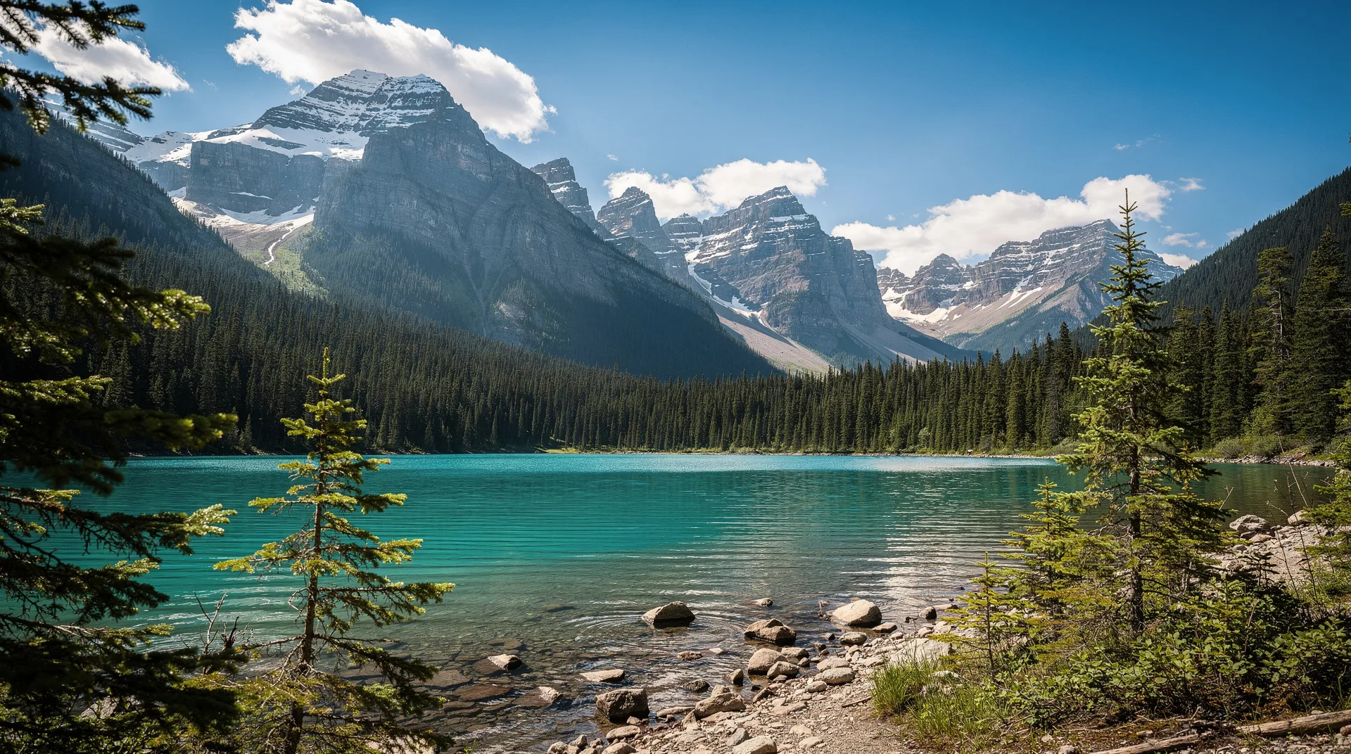
The Clearwater Lake chain — a series of lakes connected by short portages in the southern park — is the finest canoe route accessible by road in the interior of BC. Clearwater Lake and Azure Lake (linked by the Clearwater River between them) together stretch approximately 60 kilometres, with wilderness campsites managed by BC Parks at intervals. The azure colour of the lake — from glacial flour suspended in the meltwater — intensifies under clear sky to a surreal blue-green that seems improbable in a forest context.
Multi-day paddling trips of three to seven days are possible from the boat launch at the south end of Clearwater Lake, covering both lakes and their connecting river with camping on forested points and gravel beaches. The portage between the lakes (approximately 600 metres) is one of the few physical challenges in an otherwise manageable route. Wildlife encounters are reliable: moose feed in the lake shallows throughout the summer, bald eagles nest in the surrounding old-growth, and osprey dive from the air above the clear water.
The Murtle River route — connecting the eastern side of the park to the interior — is a technically demanding river paddle for experienced whitewater paddlers, requiring Class III skills and thorough preparation. Float plane access to Murtle Lake (the interior park hub) allows paddlers to complete one-way river descents.
Hiking in Wells Gray
The front-country trail network in Wells Gray rewards two to three days of hiking. The Moul Falls trail (10 km return from the Battle Mountain trailhead) is the park’s most rewarding day hike — passing through old-growth forest to a 30-metre waterfall on Moul Creek, with wading access to the pool beneath the falls a popular summer option. The return route passes beaver ponds with active lodges visible from the trail.
The Philip Lake trail offers a full-day hike to a subalpine lake with views over the volcanic plateau. The Green Mountain Lookout (18 km return) accesses an old fire lookout tower at 1,750 metres with panoramic views over the park’s forest canopy to the mountain ranges beyond — the Cariboo Mountains to the north, the Cariboo Range to the east, and the volcanic plateau rolling south toward Kamloops.
The Trophy Mountain trail system accesses the subalpine meadows of Trophy Mountain — one of the most reliable wildflower displays in BC from mid-July through August, with views extending to the peaks of the Monashee and Columbia ranges.
Wildlife in the park
Wells Gray’s wildlife list is comprehensive. Moose are the most visible large mammal — the lake shores, beaver ponds, and river margins throughout the park are reliable viewing locations, particularly in early morning and evening. Black bears are frequently seen along the Clearwater Valley Road foraging on berries in late summer, and the park’s berry crop — huckleberries, blueberries, and saskatoons — is exceptional after good summers.
Woodland caribou remain in the park’s northern and higher-elevation areas, though their numbers have declined significantly across BC’s interior. Wolves and cougars are present but rarely encountered. The park’s bird life includes boreal species uncommon on the coast: osprey, common loons, Barrow’s goldeneye, and the winter wren whose extravagant song fills the old-growth forest.
Practical information
Getting there: Wells Gray is accessed from Clearwater on Highway 5, approximately 120 kilometres north of Kamloops. Clearwater is a service town with gas stations, grocery stores, and accommodation. The park entrance is 12 kilometres east of Clearwater on the Clearwater Valley Road, with Spahats Falls at the gate and the main waterfalls and campgrounds along the 65 kilometres of paved park road north to Clearwater Lake.
Where to stay: Wells Gray Park Bungalows at Clearwater Lake have operated since 1962 and offer the most atmospheric lodging within the park. Multiple BC Parks campgrounds are scattered along the park road — Spahats Creek, Dawson Falls, and Clearwater Lake campgrounds are the most popular. Clearwater town has motels, a hostel, and vacation rentals. Helmcken Falls Lodge on the park road is the premium option, with guided day programs and comfortable rooms.
Fees: BC Parks day use and camping fees apply. Reservations through the BC Parks reservation system are strongly recommended for July and August. Winter access is limited to the main road only; Helmcken Falls is still accessible in winter but road conditions should be checked.
When to visit
Late June through September is the primary hiking and paddling season. Late June and July offer the highest waterfall volumes; July and August bring the best weather for camping and canoeing. September is the best month for wildlife (bears and moose feeding heavily) and fall colours, which arrive in the park’s deciduous forest by mid-September.
October sees the first significant snowfall at higher elevations and the closure of most campgrounds by mid-month. The waterfalls remain accessible on the main park road through October and into November in most years.
Winter: Wells Gray is not a conventional winter destination. The main park road is not plowed beyond the Clearwater Lake campground. However, winter visits to Helmcken Falls are extraordinary — the ice cone that forms in the spray zone below the falls is the park’s most dramatic winter feature, growing through December and January to its maximum extent in February. Snowshoeing access from the park road is limited but possible for experienced winter travellers.
Day trips and connections
Kamloops and Sun Peaks are both within two hours south on Highway 5. The route north from Clearwater on Highway 5 continues to Valemount and the Yellowhead Pass into Alberta — a natural extension to Jasper National Park for travellers on a longer BC-to-Alberta itinerary.
Clearwater town, at the park entrance junction, has grocery stores, gas, equipment rental, and several restaurants that serve the park’s visitor base. Clearwater is a functional service stop rather than a destination in its own right, but it has a good local diner culture and a summer market.
The Adams Lake and Chase Creek area south on Highway 5 includes the Adams River sockeye viewing site at Roderick Haig-Brown Provincial Park — combining Wells Gray with a Chase stopover makes for an excellent two or three day Thompson Interior itinerary covering the waterfalls, wilderness paddling, and the salmon run spectacle in a single loop.
Geology of the volcanic plateau
Wells Gray’s geology is among the most varied and accessible in BC — a park where volcanic, glacial, and fluvial processes have left their signatures in a landscape that can be read by any attentive observer.
The Clearwater Valley follows the eastern edge of the Quesnel Highland volcanic plateau — a vast lava landscape produced by eruptions over the past 400,000 years. The most recent activity (within the past 10,000 years) produced lava flows that reached the valley floor and whose interaction with glacial ice created spectacular ice-contact features: lava tubes, glaciovolcanic formations, and the palagonite tuff deposits visible in the canyon walls below Spahats Falls.
The lava beds in the park’s northern section are accessible by hiking trail from the park road. Tree moulds — cylindrical cavities left by trees engulfed in lava flow — are visible in the basalt surface, some preserving the impression of bark texture. The lava surface is rough, vesicular (bubble-textured), and supports a sparse pioneer vegetation of lichens and scattered pine that reinforces its geological youth.
The glacial legacy is equally readable: the lake basins in the park are glacially carved, the hanging valleys from which many waterfalls plunge (Helmcken, Dawson, Spahats) were cut by glacial erosion at different rates than the main valley, and the U-shaped profile of the Clearwater Valley itself reflects ice movement over thousands of years. The combination of volcanic and glacial geology in a single park — covering two of the dominant forces that shaped BC’s interior landscape — makes Wells Gray particularly valuable for educational visits.
Frequently asked questions about Wells Gray Provincial Park
When are the waterfalls at their best?
Late May and June for maximum volume — the park’s waterfalls are fed by snowmelt and are highest and most dramatic in the weeks following the spring melt peak. Summer (July-August) offers consistently strong flow with better weather for hiking and camping. By September, flow has decreased but remains impressive at Helmcken and Dawson.
Is Wells Gray accessible without a 4WD vehicle?
Yes. The main park road is paved to Clearwater Lake, and all the major viewpoints and campgrounds are accessible by standard passenger vehicle. The backcountry roads — to Trophy Mountain and Battle Mountain — are gravel and rough in places, but can be driven carefully in a low-clearance vehicle in dry conditions. A high-clearance vehicle is preferred for the rougher sections.
Can I swim in the park’s lakes and rivers?
Yes, though water temperatures are cold — Clearwater Lake averages around 15-17°C in July and August, cold by beach standards but swimmable for brief dips. The river pools below several waterfalls (Moul Falls in particular) are shallow and warmer on hot days. The volcanic black sand beaches on Azure Lake warm more quickly than rock shores.