Quick facts
- Location
- Route 175 North, 40 km north of Quebec City
- Best time
- June–October for hiking and paddling; December–March for winter activities
- Getting there
- 40 minutes by car north of Quebec City on Route 175
- Time needed
- Full day; 2 days for overnight camping
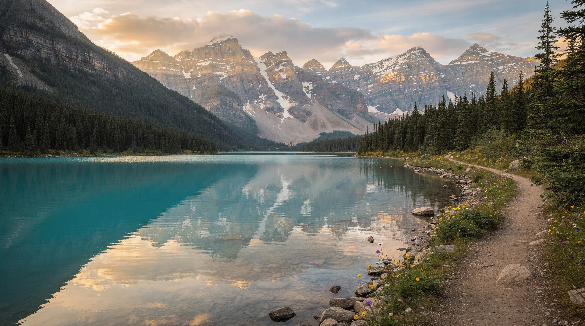
Forty minutes north of Quebec City, Route 175 descends from the Laurentide plateau into the valley of the Jacques-Cartier River — and the view that opens up stops most drivers in their tracks. The river has carved a canyon 550 metres deep through the ancient bedrock of the Canadian Shield, producing one of the most dramatic river valley landscapes in eastern Canada. The water at the bottom is the particular blue-green of a glacially fed river; the valley walls are clothed in boreal forest that shades from spruce and fir at the valley floor to the open taiga on the ridgelines above.
Parc National de la Jacques-Cartier protects 670 square kilometres of this landscape — a reserve of boreal wilderness an incongruously short drive from a UNESCO-designated historic city. The park offers more than 100 kilometres of hiking trails, a river corridor paddled by kayakers and canoeists, backcountry camping on platforms along the river, a Nordic skiing network in winter, and the extraordinary baseline experience of simply looking at the canyon from the viewpoint near the park entrance.
For visitors to Quebec City who can manage one day in the surrounding landscape, Jacques-Cartier is the strongest single recommendation. Nothing else in the immediate region has the same combination of dramatic scenery, genuine wilderness character, and activity variety.
The Jacques-Cartier River canyon
The canyon is the park’s defining feature and the first thing most visitors see: from the Vallée discovery pavilion near the park entrance, an overlook provides the full-length view of the valley — the river glinting at the bottom, the opposite valley wall rising 550 metres, and the forested ridgelines above outlined against the sky.
The canyon formed through a combination of glacial action and river erosion over the 10,000 years since the last ice age. The Laurentide ice sheet gouged and deepened existing river valleys; the Jacques-Cartier River has been cutting downward through the Canadian Shield bedrock ever since. The resulting valley has the character of a miniature fjord — straight, steep-sided walls dropping to a level valley floor — rather than the rounded profiles typical of softer rock geology.
The river running through the valley is cold year-round — fed by groundwater from the Laurentide upland — and exceptionally clear. On calm mornings, the water reflects the valley walls in a mirror image that is one of the park’s most photographed natural effects.
Hiking in the park
The trail network covers the valley floor, the valley walls, and the ridgelines above — a range of terrain that allows everything from flat riverside walks to strenuous ridge hikes with panoramic views.
Valley trails (easy)
Several trails on the valley floor run along the river or through the boreal forest at the base of the valley walls. These are accessible to most fitness levels and provide the best riverside scenery — views across the turquoise water to the opposite valley wall, access to small beaches on the river bends, and opportunities for wildlife observation in the early morning.
The Corridor trail (Sentier du Corridor) follows the river for several kilometres and is the standard route for visitors with limited time. The flat terrain and the continuous river views make it satisfying even for those who do not intend to hike more demanding terrain.
Valley wall trails (moderate)
Several trails ascend the valley walls to intermediate viewpoints — perspectives looking down into the valley rather than along it. The Les Loups trail is one of the better-known: a moderately steep ascent through mixed forest to a series of viewpoints at the valley rim, with views northeast down the river valley and west across the Laurentide plateau.
These trails typically take 2–4 hours for a return trip and involve significant elevation gain (300–400 metres). Good footwear and water are essential. The views from the intermediate viewpoints justify the effort for most visitors.
Ridgeline trails (strenuous)
The most demanding trails reach the park’s ridgelines at elevations above 850 metres, where the vegetation transitions from boreal forest to open subalpine terrain with krummholz (stunted wind-blasted trees) and exposed Canadian Shield rock. The views from the ridgelines — across the Laurentide plateau in all directions, with the Jacques-Cartier valley below — are among the best highland views accessible on a day hike from a major Canadian city.
The Sentier du Mont du Lac des Cygnes trail (accessible from a separate trailhead at the park’s northern sector) reaches an elevation of 896 metres and is considered one of the best day hikes in the Quebec City region. Allow 6–8 hours for the full circuit.
Kayaking and canoeing the river
The Jacques-Cartier River is one of the premier whitewater kayaking rivers in eastern Canada, with a range of rapids from class II to class IV in its upper sections. The park manages kayaking access and provides guided kayak tours on the calmer valley floor sections for visitors without whitewater experience.
For experienced paddlers, the upper sections of the river offer technical whitewater that requires skill and appropriate equipment. Park staff at the Vallée pavilion can advise on current conditions and appropriate skill levels for different sections.
The flat-water sections of the river through the valley floor are excellent for recreational kayaking and canoe day trips. Rentals are available at the park’s service centre. A one-way paddle from the upper launch point to the Vallée pavilion, with a shuttle return, is the standard guided option and takes 3–4 hours.
Book outdoor adventure tours near Quebec City on GetYourGuideBackcountry camping
The park operates backcountry campsites on elevated platforms along the river — Le Refuge camping platforms that keep tents dry in the frequently wet boreal forest and provide a genuine wilderness experience accessible to campers who do not need to carry tents or heavy shelter gear.
The platform campsites are accessible by walking or paddling and must be reserved in advance through the Sépaq reservation system. A night on the river — listening to the water below and the owls in the spruce above, with no light pollution on the darker nights — is one of the most accessible wilderness experiences within easy reach of Quebec City.
For those who prefer a roof, the park also operates heated chalets and yurts in the valley — a comfortable year-round option that eliminates the need for camping equipment.
Wildlife watching
The boreal forest of Jacques-Cartier supports a range of wildlife typical of the Laurentide region: white-tailed deer and woodland caribou (in the park’s northern sectors), black bear, moose, beaver, river otter, and an excellent variety of boreal bird species.
Moose sightings are most common in the early morning and late evening in the valley floor areas, where the river’s edge provides the aquatic vegetation that moose browse. The probability of a moose encounter in the Jacques-Cartier valley is significantly higher than in most Quebec City day-trip destinations and is one of the park’s signature wildlife experiences.
Caribou (reindeer) in the northern sectors of the park are more elusive — the herds are small and their ranges extensive — but the park is one of the southernmost locations where woodland caribou can still be observed.
Winter in the park
In winter, Jacques-Cartier transforms into one of Quebec’s best Nordic skiing destinations. The park grooms approximately 180 kilometres of cross-country ski trails ranging from easy valley floor loops to demanding ridge routes. The valley setting — sheltered from wind at the lower elevations, exposed and challenging at the ridgelines — provides variety for skiers at all levels.
Snowshoeing trails are maintained separately from the ski trails. The winter forest experience in the valley — deep snow, the river running partially beneath ice in the coldest months, the silence of the boreal winter broken only by the wind in the spruce — is dramatically different from summer and equally worthwhile for visitors willing to embrace the cold.
The park operates in winter with heated service centres and emergency facilities; the same platform camping and chalet accommodation is available in winter as in summer. Winter camping in the boreal forest, with the northern lights visible on clear nights, is for committed cold-weather enthusiasts only — but those who do it reliably describe it as one of the most extraordinary experiences available in the Quebec City region.
Combining Jacques-Cartier with Wendake
The most efficient day trip combining two of the north country’s best experiences takes Route 175 north from Quebec City — passing through Wendake (15 kilometres north) on the way to the park entrance (40 kilometres). A morning cultural experience at the Huron-Wendat village, followed by an afternoon at the Jacques-Cartier canyon, covers both in a single day. The return drive through Wendake allows for dinner at La Traite restaurant if timing allows.
Practical information
Getting there: Route 175 north from Quebec City leads directly to the park entrance. The drive takes approximately 35–40 minutes from Old Quebec without traffic. In winter, the highway is maintained but can be icy; winter tires are mandatory in Quebec from December 1 to March 15.
Sépaq reservation: Entry to the park is included with Sépaq annual passes or purchased at the entrance gate. Backcountry camping, kayak rentals, and guided activities must be reserved in advance through the Sépaq website, especially in peak summer months (July–August) when the park is busy.
What to bring: Layered clothing (the valley floor can be significantly cooler than Quebec City), good hiking footwear, water (the river water is not potable without treatment), and lunch or snacks. The park has a snack bar at the Vallée pavilion but no full restaurant.
Wildlife: The park recommends carrying bear spray and knowing how to use it on backcountry trails. Bear encounters in the picnic and trail areas are rare but possible. Follow standard food storage protocols when camping.
Entry point: Most visitors use the main Vallée sector entrance on Route 175. The park’s northern Tewkesbury sector (a separate entrance via Route 369) provides access to different trails and is less crowded.
Related pages
Jacques-Cartier Park is most naturally combined with Wendake as a day trip north of Quebec City. For the full range of excursion options, the day trips guide covers all major destinations. The winter guide includes the park’s winter skiing in the context of Quebec City’s full cold-season offering. For families, the with kids guide addresses which trails and activities are appropriate for children at different ages.