Quick facts
- Best time
- June–September (park fully open)
- Days needed
- 3-5 days
- Languages
- English
- Distance from St. John's
- 700 km (9 hours by car)
Gros Morne National Park is where the Earth turns itself inside out. The Tablelands — a plateau of orange-ochre peridotite rock visible from the Trans-Canada Highway near Trout River — are literally ancient ocean floor, forced to the surface 450 million years ago when tectonic plates collided. This rock is mantle material, toxic to most plants because of its chemistry, and almost nothing grows on it. The result is a Martian landscape in the middle of Newfoundland: bare orange rock above a green valley, surrounded by spruce forest, set against the Atlantic sky. It is one of the most geologically significant exposures in the world, and it looks like nothing else in Canada.
The park earned its UNESCO World Heritage designation in 1987 on the strength of this geology — the exposed ocean crust and mantle rock provided crucial evidence for the theory of plate tectonics, because geologists could walk across the ancient suture zone where two plates once collided. But Gros Morne’s case for greatness does not rest on geology alone. The Long Range Mountains — the most northerly extension of the Appalachians — rise to the park’s northern and eastern borders. Western Brook Pond is a landlocked fjord, formed when glacial erosion carved a valley 16 kilometres into the plateau and the land rebounded after the ice melted, cutting the water body off from the sea. The cliffs that rise 600 metres above Western Brook Pond are the tallest in eastern North America, and the experience of being in a boat at their base — tiny beneath walls of ancient rock — is genuinely humbling.
Top things to do in Gros Morne National Park
Hiking the Gros Morne Mountain trail
The park’s signature hike climbs to the summit of Gros Morne Mountain (806 metres) through a landscape that changes dramatically with altitude. The lower slopes are boreal forest — black spruce, balsam fir, yellow birch — transitioning to open heath and then the bare summit plateau, an arctic-alpine environment above the treeline where caribou graze and the wind is a constant force.
The trail is 16 kilometres return with 800 metres of elevation gain, classified as strenuous. The upper section involves a steep scramble on loose rock before the summit plateau is reached. The plateau itself, once gained, is a revelation: a flat table of rock and lichen with 360-degree views of the park, the Gulf of St. Lawrence, and on clear days the Quebec shore across the water.
The trailhead is at the Berry Hill campground area. The hike typically takes 6–8 hours return; start by 8am at the latest in summer to allow for weather changes on the exposed summit. The mountain generates its own weather — summit conditions can be dramatically different from the trailhead, and cloud can close in very quickly. Check the park’s trail conditions report before starting.
Western Brook Pond boat tour
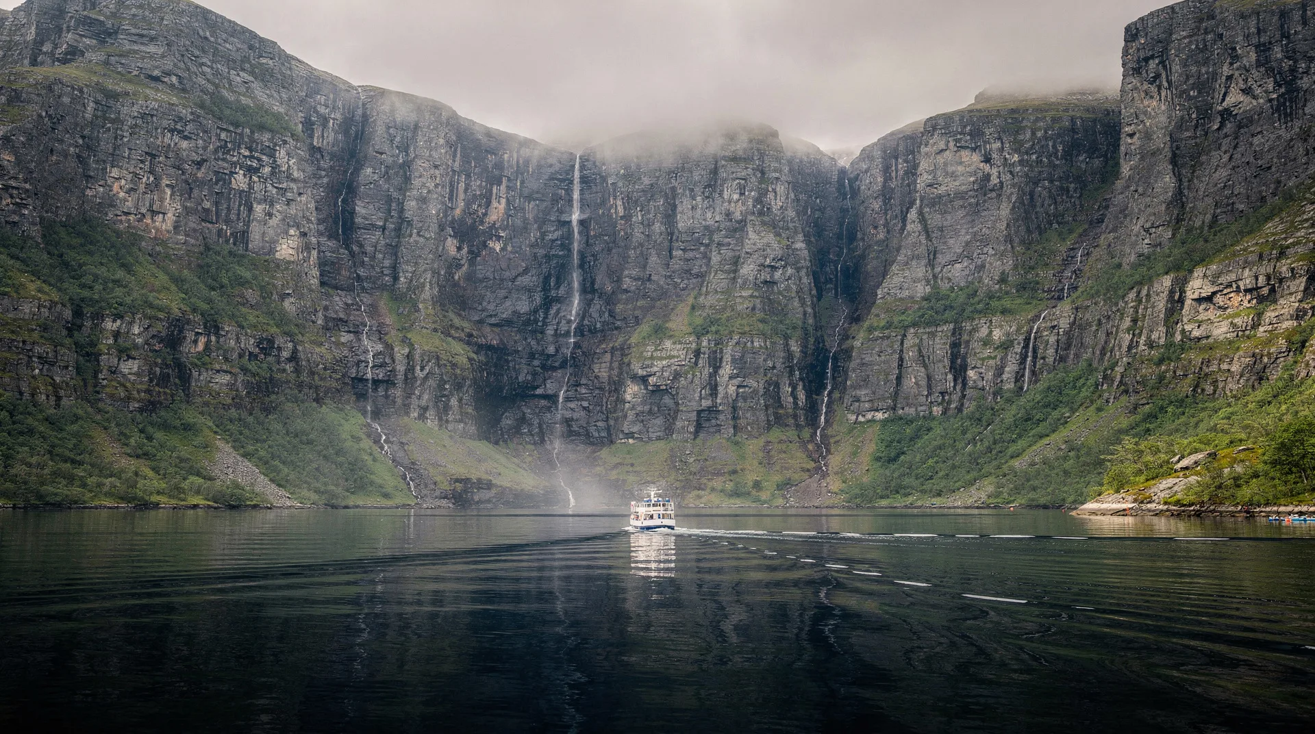
Western Brook Pond is the park’s most accessible spectacle — a 3-kilometre flat walk through bog and forest from the highway parking area leads to the pond’s southern shore, where a boat tour departs twice daily in summer to travel the 16-kilometre length of the fjord to the head wall where waterfalls drop from the plateau edge.
The boat tour takes approximately 2 hours return and is the only way to reach the inner fjord under normal circumstances. The scale of the cliffs from the water — vertical walls of 1.2-billion-year-old gneiss rising 600 metres — cannot be communicated by photographs, which consistently fail to convey the height. The waterfalls at the head wall, fed by the high plateau bog above, are seasonal: most powerful in June after snowmelt and after heavy rain, reduced to thin threads by late August in dry years.
Book the Western Brook Pond boat tour in advance through the park’s concessionaire — the tours fill weeks ahead in July and August. Mornings are typically calmer; afternoon crossings can be cancelled if the fjord is too windy (the wind funnels through the rock walls at the far end and can create difficult conditions even when the weather outside the park seems fine).
Browse Newfoundland nature adventures and national park tours on GetYourGuideWalking the Tablelands
The Tablelands trail is the park’s most geologically significant walk and one of the most otherworldly landscapes in Canada. The trailhead is at Trout River, and the maintained trail follows the base of the Tablelands plateau for 4 kilometres return through the former suture zone — the interface between ancient ocean floor and continent, now exposed as a rust-orange wasteland of peridotite rubble.
Walking the Tablelands, you notice immediately that the vegetation changes. Along the trail edges, the spruce forest that covers most of Gros Morne is absent. The peridotite is high in magnesium and iron, deficient in calcium, and contains nickel and chromium in concentrations toxic to most plant species. Only specialist plants adapted to serpentine soils grow here — a spare community of hardy species quite different from the forest a few hundred metres away on normal rock.
The park’s interpretive signs explain the geology accessibly, but the stronger experience is simply standing in the middle of a landscape that looks wrong — the wrong colour, the wrong vegetation, the wrong geological logic — and understanding that you are standing on rock that was once 30 kilometres below the ocean floor.
Hiking the Green Gardens trail
The Green Gardens trail on the park’s southern shore (near Trout River) provides a contrasting landscape to the Tablelands — volcanic rock sea stacks, sea caves, and sea arches on the Gulf shore, with coastal meadows (the “Green Gardens”) above the cliffs. The trail is 9–12 kilometres in its full loop version, with a steep descent to the shore. The sea stack formations at the bottom are architecturally striking and accessible only via this trail.
The combination of Tablelands in the morning and Green Gardens in the afternoon makes for one of the best single-day itineraries in the park — geological contrast at the level of different planets.
Sea kayaking in Bonne Bay
Bonne Bay is a fjord-arm that cuts into the park from the Gulf, dividing the park into its northern and southern sections. The sheltered waters of the bay’s inner arms, particularly the East Arm between Woody Point and Glenburnie, are excellent for sea kayaking — calm, fjord-enclosed water with the Long Range Mountains as backdrop.
Kayak rental and guided tours operate from Rocky Harbour and Woody Point through the summer season. The park’s interpretive boat tours on Bonne Bay are a more passive option, with a naturalist guide explaining the fjord ecology.
Geology for non-geologists
Understanding what makes Gros Morne special does not require a geology background — the visual evidence is readable without technical knowledge. The key observation is the colour contrast: the orange-brown of the Tablelands against the green-grey of the surrounding mountains is a direct expression of the chemical difference between ocean mantle and continental crust. The normal rock of the Long Range Mountains is grey metamorphic gneiss — ancient continental basement. The Tablelands are literally from a different geological environment entirely: the mantle of the earth, thrust to the surface by the violence of two plates colliding.
The park’s visitor centre in Rocky Harbour has excellent interpretive exhibits explaining the geological story at a level accessible to non-specialists. Spending an hour here before visiting the Tablelands and Western Brook Pond substantially enriches both experiences.
When to visit Gros Morne
June: The park is fully open from early June, with waterfalls at their most powerful from snowmelt. Moose (extremely numerous here — Newfoundland has one of the highest moose densities in the world) are visible in bogs and roadsides. The weather is changeable; some higher trails may have snow on the summit plateau into early June.
July and August: Peak season with all boat tours, guided hikes, and facilities operating. The weather is the most reliable. The park is busy by Newfoundland standards — not by national park standards in general — and accommodation in Rocky Harbour and Woody Point fills quickly. Book 3–6 months ahead for summer visits.
September: Excellent for hiking — cooler, less crowded, and the fall colour on the Long Range Mountain slopes begins in late September. Some boat tours operate reduced schedules from mid-September; confirm in advance. Moose rut in September makes wildlife sightings more frequent and more animated.
October to May: The park is essentially closed to casual visitors — most trails remain accessible but the boat tours, campgrounds, and many visitor facilities are shut. Winter is genuinely remote and requires full self-sufficiency.
Where to stay near Gros Morne
Rocky Harbour is the park’s main service centre — a working Newfoundland fishing village with hotels, B&Bs, a few restaurants, and the main visitor centre. The Ocean View Hotel is the largest and most reliable accommodation option; several smaller B&Bs and guesthouses offer more personal service. Rocky Harbour is the best base for the northern park (Gros Morne Mountain, Western Brook Pond).
Woody Point on the southern arm of Bonne Bay is quieter and more atmospheric — a small historic community with the park’s southern visitor centre and access to the Tablelands. The Victorian Manor is the most characterful accommodation option in the park area.
Trout River at the southern park boundary is the smallest and most remote base — a handful of B&Bs and the excellent Seaside Restaurant, with direct access to the Tablelands and Green Gardens.
Camping: The park has several campgrounds, with Shallow Bay on the northern coast and Trout River Pond in the south being the most scenically positioned. Serviced sites with electrical hookups at Berry Hill campground near Rocky Harbour are popular with RV visitors.
Getting there
From Deer Lake (the nearest airport, served by Air Canada and WestJet from Halifax and Toronto): Highway 430 north to Rocky Harbour, approximately 50 kilometres and 45 minutes.
From St. John’s: Trans-Canada Highway (TCH) west across the island, 700 kilometres and approximately 9 hours — a long day’s drive. The highway crosses the island’s interior through boreal forest and exposed Newfoundland barrens; it is not a particularly scenic drive but is genuinely Newfoundland in character. Breaking the journey in Grand Falls-Windsor (midpoint) is recommended.
By ferry: The Marine Atlantic ferry from North Sydney, Nova Scotia docks at Port aux Basques at the island’s southwest corner — approximately 4 hours further from Gros Morne than the TCH crossing point, but the ferry adds a maritime dimension to the journey and eliminates the St. John’s detour.
Getting around the park: A car is essential. The park’s two main sections — north (Rocky Harbour/Western Brook Pond) and south (Woody Point/Tablelands) — are connected by a 25-minute ferry across Bonne Bay, which runs several times daily in summer, or by a 60-minute road detour via Wiltondale. The ferry is more scenic and worth taking at least once.
L’Anse aux Meadows and the Viking connection
Gros Morne is the geological destination of Newfoundland’s Northern Peninsula; L’Anse aux Meadows is the historical one, and both are typically combined on a Northern Peninsula itinerary. L’Anse aux Meadows, 265 kilometres north of Rocky Harbour via Highway 430, is the only confirmed Norse settlement in North America — the site where Leif Eriksson and the Greenlanders landed around 1000 CE and built eight turf-sod buildings that survived beneath the bog until archaeological excavation in the 1960s confirmed their Viking origin.
The site is a UNESCO World Heritage Site and is operated by Parks Canada with reconstructed buildings and costumed interpreters. The experience of standing in a reconstructed Norse longhouse at the northern tip of Newfoundland, 1,000 years of Atlantic weather later, carries a weight that museum artifacts cannot replicate. A stop at L’Anse aux Meadows requires an additional day at minimum; many visitors extend a Gros Morne trip to a week’s Northern Peninsula circuit that includes both parks.
Practical tips
Moose: Newfoundland has the highest moose density of any Canadian province, and Gros Morne concentrates this. Moose-vehicle collisions are the primary hazard on Newfoundland roads, particularly at dawn and dusk. Drive slowly on park roads in low-light conditions, and expect to see moose regularly — they are not a rare wildlife sighting here but a daily road hazard.
Weather: The Long Range Mountains generate their own weather systems. Park conditions can shift from clear to socked-in fog in minutes. Always carry waterproofs and extra layers, and file a hiking plan with the park visitor centre if doing any backcountry routes.
Blackflies and mosquitoes: June is the peak season for biting insects in the boreal forest sections of the park. Bring effective repellent. By mid-July, the worst has usually passed.
Provincial time zone: Newfoundland operates on Newfoundland Standard Time — 30 minutes ahead of Atlantic Time (1.5 hours ahead of Eastern). This is not a mistake; it is a deliberate Canadian quirk that Newfoundlanders are entirely comfortable with.
Is Gros Morne worth the journey?
Gros Morne is the most geologically significant national park in Canada and one of the genuinely exceptional UNESCO World Heritage Sites on the continent — not because of a single dramatic feature but because of the coherent, spectacular strangeness of its assembled landscapes. The Tablelands, Western Brook Pond, the Long Range Mountains, Bonne Bay, and the coastal headlands each function as a distinct environment, and their juxtaposition within a 1,805-square-kilometre park creates a completeness of experience rare in any natural area. The journey is long — there is no avoiding this — but Newfoundland rewards the effort at every scale, and Gros Morne is why you go to the island.