Quick facts
- Route length
- 885 km full peninsula loop from Sainte-Flavie
- Best time
- Mid-June to mid-October; peak mid-July to late August
- Days needed
- 7 days minimum; 10 days for unhurried exploration
- Start point
- Sainte-Flavie (from Quebec City: 5 hrs east on Route 132)
National Geographic once named the Gaspésie peninsula one of the world’s top 50 drives. Any Quebecer who has done the full loop will tell you they undersold it. The 885-kilometre circuit from Sainte-Flavie around the tip at Percé and back along the southern Chaleur Bay coast combines dramatic Atlantic cliffs, the highest mountains east of the Canadian Rockies, the most-photographed rock formation in Canada, a UNESCO fossil site, Acadian fishing villages, world-class seafood, and a sense of genuine remoteness that almost no other North American road trip matches within a day’s drive of a major city.
This guide lays out the classic 7-day loop from Quebec City, with day-by-day driving distances, recommended stops, accommodation advice, and the adjustments you can make for a shorter or longer trip. The loop runs counterclockwise as described here (north shore first, southern Chaleur Bay coast returning) — this is the most common direction and puts the most dramatic scenery (Forillon to Percé) in the middle of your trip when you’ve warmed up but before you’re fatigued.
Overview
- Total distance from Quebec City: roughly 1,885 km with the full peninsula loop included.
- Minimum days: 7 for the loop itself, ideally 8–10 with unhurried stops.
- Best direction: counterclockwise (Sainte-Flavie → Matane → Gaspé → Percé → Chaleur Bay → Matapédia → Sainte-Flavie).
- Peak season: July and August. Book accommodation 2–3 months ahead for Percé and Gaspé.
Day 1: Quebec City → Sainte-Flavie → Matane (320 km, ~5 hrs driving)
Leave Quebec City early on Route 20 east. The drive through Bas-Saint-Laurent is itself worth slowing down for — the St. Lawrence widens dramatically around Rimouski, the villages (Kamouraska, L’Islet, Rivière-du-Loup) are pretty, and the BSL Rose des Vents scenic route signage marks worthwhile detours.
Afternoon stop: Sainte-Flavie marks the official start of the Gaspésie. The Centre d’Art Marcel Gagnon and its famous “Le Grand Rassemblement” statue installation along the beach makes a 45-minute pause.
Evening: continue to Matane. Sleep in a waterfront motel; dinner is salmon or Matane shrimp in any riverside restaurant.
Alternative: if you left very early, push on to Sainte-Anne-des-Monts for tomorrow’s head start on Forillon.
Day 2: Matane → Sainte-Anne-des-Monts → Gaspé (360 km, ~5.5 hrs)
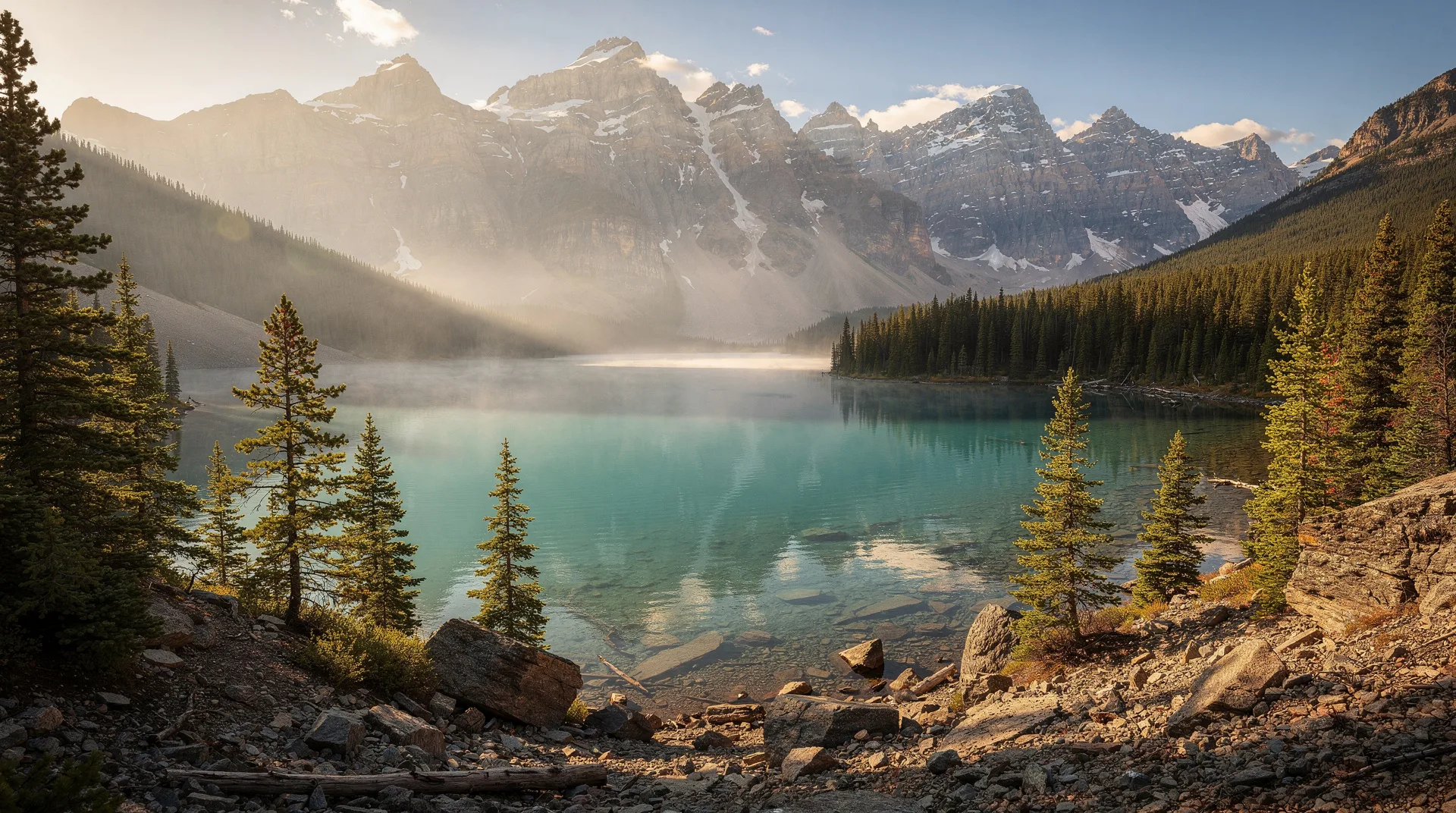
This is the big north-shore driving day along the most dramatic stretch of the peninsula. Route 132 hugs the coast beneath the Chic-Chocs — the easternmost extension of the Appalachians and the highest peaks in Quebec outside the Laurentians.
Morning detour (2–4 hours): take Route 299 south from Sainte-Anne-des-Monts to Parc national de la Gaspésie for hiking Mont-Albert or Mont-Jacques-Cartier. If you’re not hiking, at minimum drive the 20 km in to the park entrance and interpretive centre — the mountain scenery is dramatic and the caribou herd (though increasingly rare) occasionally appears near the road.
Afternoon: continue east along Route 132. The highway runs along a narrow shelf between the ocean and the mountain walls. La Martre lighthouse, Mont-Saint-Pierre (Quebec’s hang-gliding capital), and the tiny fishing port of Rivière-au-Renard all merit brief stops.
Evening: arrive Gaspé. This is the old capital of the peninsula — Jacques Cartier raised his cross here in 1534, marking the arrival of French presence in Canada. The Musée de la Gaspésie covers the region’s history.
Day 3: Gaspé + Forillon National Park (~120 km driving, full day)
Parc national de Forillon is the first federal national park in Quebec (1970) and one of the most dramatic in Atlantic Canada. The peninsula ends in a 30-kilometre spine of limestone cliffs rising 200 metres from the sea, and the park protects this final reach of land where the Appalachians meet the Atlantic.
Morning: drive the Cap-Gaspé road to the Cap-Bon-Ami viewpoint and the Anse-Blanchette historical site. Park at the Grande-Grave interpretive centre, walk to Cap-Gaspé lighthouse (4 km return) — this is the hike that takes you to the literal “land’s end” of the Appalachians.
Afternoon: whale watching. Forillon is one of the best land-based whale-watching spots in eastern Canada — minke, fin, blue, and humpback whales all pass within sight of the coast between June and October. The Cap-Bon-Ami viewpoint is the best spot. Alternative: join a GYG-bookable whale watching Zodiac tour from Grande-Grave (2.5 hrs, around $90).
Evening: dinner in Gaspé or push on to your Percé accommodation if you booked ahead.
Day 4: Percé + Bonaventure Island (~40 km driving, full day)
Percé Rock is the signature image of the Gaspésie. The massive pierced limestone formation offshore is 88 metres tall and instantly recognisable. The village of Percé is touristy in a pleasant, compact way — colour-washed houses, seafood restaurants, boutique shops, and a well-maintained boardwalk.
Morning: the Bonaventure Island boat tour (included in Sépaq day pass: $9.60 adult) is the day’s main event. The island hosts one of the largest northern gannet colonies in the world — 110,000 birds nesting densely on the cliffs. Boats run every 30 minutes from Percé harbour, with a 15-minute crossing. Hike the 3.5-km loop trail from the landing to the gannet colony at Les Colonies. Budget 4–5 hours.
Afternoon: walk the beach to Percé Rock at low tide (you can walk out to the rock for 1–2 hours around low tide). Ride the Percé UNESCO Global Geopark gondola up Mont Sainte-Anne for panoramic views and the Glass Platform (suspended walkway over a 200-metre drop) — $22 per adult, 2 hours including the hike.
Evening: Percé for dinner. The Café des Artistes has strong food and live music; La Maison du Pêcheur is the classic seafood choice.
Day 5: Percé → Miguasha → Carleton-sur-Mer (310 km, ~4 hrs with stops)
Route 132 loops around the southeastern tip through Chandler and Port-Daniel before entering Chaleur Bay proper.
Morning detour: Parc national de Miguasha — a UNESCO World Heritage Site for its Devonian-period fish fossils (375 million years old). The small interpretive museum is genuinely excellent and one of the most important paleontology sites in the world for understanding the transition from fish to tetrapods. 2 hours including a fossil-bearing cliff walk.
Afternoon: continue west along the Chaleur Bay coast. Bonaventure is the main Acadian heritage centre — the Musée Acadien du Québec in Bonaventure covers the Gaspésie’s French-speaking Acadian population, deportees from the Grand Dérangement who resettled here in the late 1700s.
Evening: overnight in Carleton-sur-Mer, an attractive Acadian beach town with a bold concrete waterfront complex, a microbrewery and good seafood.
Day 6: Carleton → Matapédia → Sainte-Flavie (280 km, ~4 hrs)
The return loop along the Matapédia Valley is the gentlest section of the drive — rolling farmland, salmon rivers, small villages.
Morning: short drive to Pointe-à-la-Croix and the Battle of the Restigouche National Historic Site (site of the last French naval battle in North America, 1760). 90 minutes.
Afternoon: follow Route 132 then Route 17 up the Matapédia River valley. The Matapédia is one of the most famous Atlantic salmon rivers in the world — Prince Charles has fished here. Amqui and Causapscal are the main towns; both have modest motel stock.
Evening: return to Sainte-Flavie, closing the loop. Dinner and overnight.
Day 7: Sainte-Flavie → Quebec City (320 km, ~5 hrs)
Direct drive back via Rimouski, Rivière-du-Loup and the south shore of the St. Lawrence. Stop at the Bas-Saint-Laurent scenic points (Kamouraska, Saint-Jean-Port-Joli) if time permits.
Adapting the itinerary
- 5-day version: drop Day 1 stops (straight to Gaspé), condense Percé + Bonaventure to one busy day, skip Miguasha.
- 10-day version: add 2 nights in Percé for more hiking, 1 night in Forillon for overnight hike, 1 night in Carleton for a proper beach day.
- Counter-direction: some prefer clockwise (Chaleur Bay first, dramatic Forillon/Percé last) — it works but leaves the harder driving (Rimouski back to Quebec City) for your last day.
Practical tips
- Fill your tank at every opportunity — gas stations are limited past Sainte-Anne-des-Monts and can close early in shoulder seasons.
- Book Percé and Gaspé lodging by May for July/August travel.
- Pack for 15-25°C daytime, cooler evenings even in August — the Gulf air is always cool.
- Download offline maps — cellular coverage is patchy along the north shore between Matane and Gaspé.
- Rental car: almost all travellers drive from Quebec City or Montreal. One-way rentals to/from Gaspé airport exist but are expensive.