Quick facts
- Located in
- South shore Gaspésie, Quebec
- Best time
- July–August (swimming); September (quieter)
- Getting there
- Highway 132 south shore from Percé or via Matapédia from New Brunswick
- Days needed
- 2-3 days
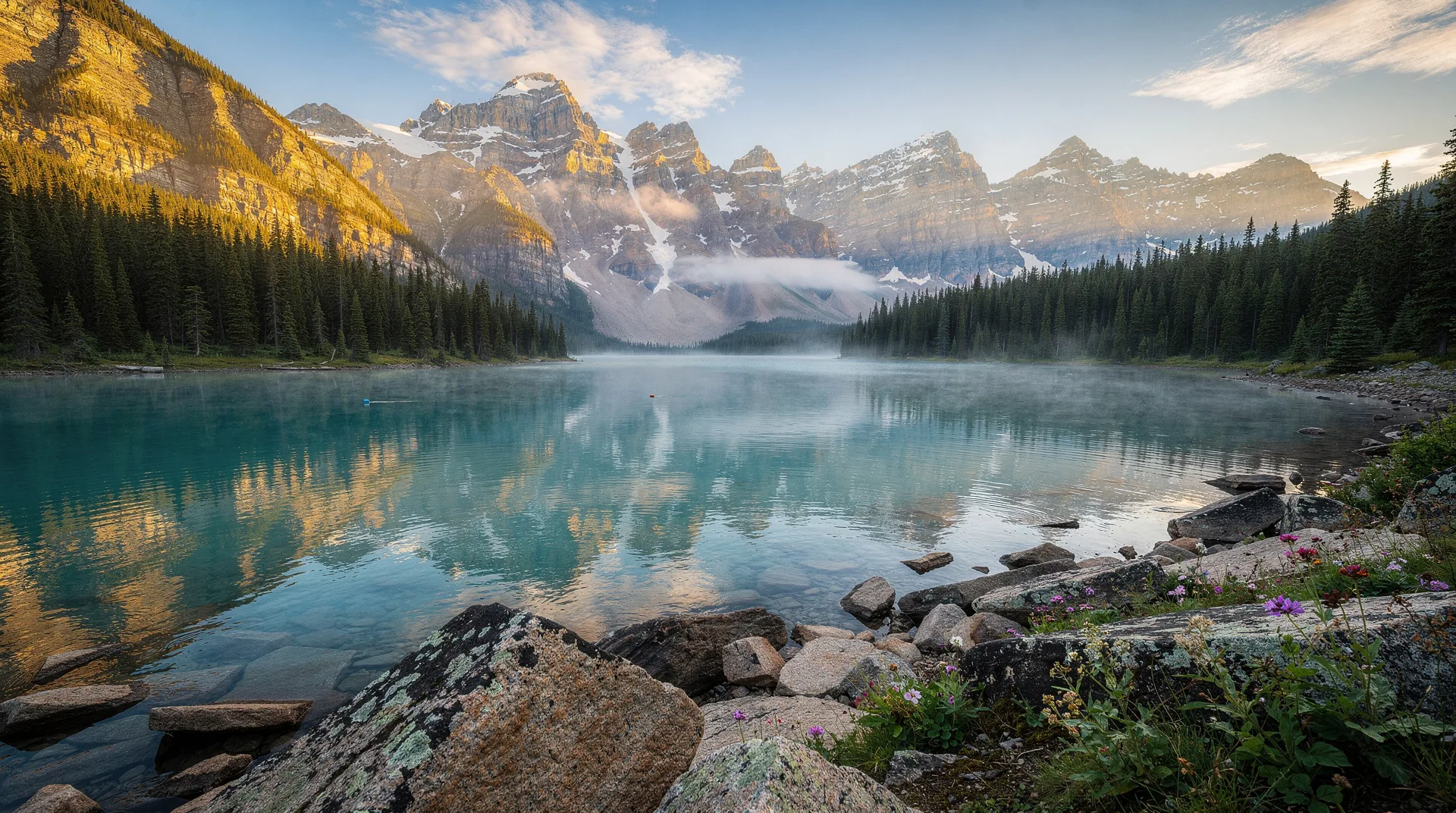
Jacques Cartier sailed into the bay in 1534 and named it for its warmth — Baie des Chaleurs, the Bay of Warmth. It was a reasonable assessment. The Baie-des-Chaleurs is a semi-enclosed body of water between the south shore of the Gaspésie peninsula and the coast of New Brunswick, and its sheltered position allows the surface water to warm to temperatures that are high by Atlantic Canada standards — 22–24°C in July and August on calm, sunny days. This makes it one of the few places in Quebec where ocean swimming is genuinely comfortable rather than merely bracing, and it is one of the defining features of the south shore experience.
The Baie-des-Chaleurs coast is the return leg of the Gaspésie peninsula circuit for most visitors — after the drama of Percé Rock, Forillon, and the Chic-Chocs, the south shore is more pastoral, lower-key, and in some ways more human-scaled. The towns are fishing communities with Acadian and Mi’gmaq heritage, the landscape is gently rolling rather than dramatically vertical, and the pace encourages lingering rather than rushing from viewpoint to viewpoint. The south shore also contains Miguasha National Park, a UNESCO World Heritage Site for its Devonian fossil beds — one of the most scientifically significant geological sites in the world, and easily one of the most undervisited.
The bay and its towns
The Baie-des-Chaleurs coast runs approximately 200 kilometres from Percé in the east to Matapédia at the New Brunswick border in the west. Highway 132 follows the coast the entire distance, passing through a sequence of fishing and former fishing communities.
Percé to Chandler: The eastern section has a more industrial character than the rest of the south shore — the paper and fishing industries have left visible marks on the towns. Chandler itself is a paper mill town transitioning toward tourism. The coast here has beaches but they are less developed than further west.
New Richmond and Bonaventure: The central section of the bay features some of the best beaches. New Richmond is an English-speaking community with a heritage village (Centre de l’héritage britannique) documenting the history of the Loyalist settlers who came here after the American Revolution. Bonaventure is primarily francophone with Acadian heritage — the Musée acadien du Québec here is the major cultural institution for Acadian history on the peninsula.
Carleton-sur-Mer: The most attractive town on the south shore by most assessments — a beach community with a good restaurant scene, hotels on the waterfront, and the Mont Saint-Joseph behind the town (accessible by car or by trail) offering panoramic views of the bay. The beach at Carleton is one of the better swimming beaches on the coast, and the town’s marina is active in summer. Carleton has been developing a reputation as a food destination with chefs using local fish and agricultural products.
Matapédia: The western gateway to the peninsula where the Matapédia Valley begins. The Restigouche River here is one of Quebec’s famous Atlantic salmon rivers, and the village marks the border with New Brunswick. The Via Rail Chaleur train passes through Matapédia on its way from Montreal to Gaspé.
Beaches and swimming
The beaches of the Baie-des-Chaleurs are the primary summer draw for families from Quebec City and Montreal who make the peninsula trip in July and August. Several beaches stand out.
Plage de Carleton: The main beach at Carleton-sur-Mer, with facilities, lifeguard coverage in season, and the warmest water access at the western end of the bay. The beach orientation means afternoon sun and calm conditions in most summer weather patterns.
Plage de Paspébiac: A long sand beach with shallow entry — excellent for families with young children. The warm shallow water heats quickly and stays warm through August.
Plage de New Richmond: Another long beach with good facilities and a local atmosphere less touristic than Carleton. The surrounding dunes provide wind protection on days when the bay breeze picks up.
Miguasha: The cliffs near Miguasha National Park have a small beach below the fossil site accessible at low tide — an unusual combination of swimming and geological tourism.
Cycling the south shore
The south shore of the Baie-des-Chaleurs is one of the best cycling sections of the Route Verte (Quebec’s intercity cycling network), with a dedicated path and low-traffic roads running close to the bay. The relatively flat terrain, warm temperatures in July and August, and the sequence of towns with accommodation and services make it practical for cyclists on multi-day tours.
The full Bonaventure-to-Matapédia section is approximately 100 kilometres of cyclable route, comfortable over 2 days with overnight stops. Carleton-sur-Mer is the natural midpoint. Bike rentals are available in several towns.
The cycling experience on the south shore contrasts with the north shore of the peninsula, where the terrain is more challenging (the Chic-Chocs push closer to the coast and the road climbs over several headlands). South shore cycling is accessible to recreational cyclists of intermediate fitness.
Miguasha National Park
On the south side of the peninsula between Carleton-sur-Mer and Matapédia, Miguasha’s coastal cliffs contain the world’s finest representation of the Devonian Period (approximately 375–360 million years ago) — specifically, the evolutionary transition from aquatic to terrestrial life. The fish preserved in the Miguasha formation include Eusthenopteron foordi, a lobe-finned fish that is a direct ancestor of all tetrapods (four-limbed vertebrates, including humans), and Elpistostege watsoni, an even more transitional form with primitive limb structures that was discovered here in the 1930s and updated significantly by a new specimen found in 2010.
UNESCO designated Miguasha a World Heritage Site in 1999. The park’s interpretation centre explains the paleontological and evolutionary significance in a way that is genuinely accessible to non-scientific visitors — the displays connect the ancient fish in the cliffs to living vertebrate anatomy in a way that makes the evolutionary argument concrete. Guided tours of the cliff face where active excavation occurs are available throughout the season.
For children, the combination of real fossil excavation activity visible from the guided tour routes, and the park’s interpretive programming explaining how these old fish are our ancestors, tends to produce genuine engagement rather than passive museum-viewing.
Book Gaspésie and Quebec region tours on GetYourGuideAcadian and Mi’gmaq heritage
The Baie-des-Chaleurs has been continuously inhabited by Mi’gmaq people for thousands of years before European arrival, and the Gespeg First Nation maintains a presence in the region. Several communities offer cultural programming and arts related to Mi’gmaq heritage.
The Acadian communities of the south shore descended from French settlers displaced during the British deportation of 1755 who eventually made their way back to Quebec. The Musée acadien du Québec in Bonaventure documents this history with genealogical records, cultural objects, and archives that are particularly valuable for the Acadian diaspora researching family histories.
The culinary dimension of Acadian heritage is worth noting: the south shore has its own regional food traditions built around seafood, root vegetables, and the particular forms of bread and pastry that Acadian communities maintained across the centuries of displacement. Several restaurants on the south shore draw on these traditions deliberately.
Atlantic salmon fishing
The rivers flowing into the Baie-des-Chaleurs from the Gaspésie interior — the Restigouche, the Cascapédia, the Bonaventure, and others — are among the most prestigious Atlantic salmon rivers in North America. Fly fishing for Atlantic salmon on these rivers requires a guide, a licence, and a reservation on a stretch of water that is typically controlled by private clubs or Indigenous communities, and the economics of the sport salmon fishing industry here are not casual. But for serious fly fishermen, this is one of the most coveted fishing destinations in the world.
The Cascapédia River has a particular historical prestige — it was fished by British royalty and American presidents in the 19th and early 20th centuries, and the Cascapédia River Museum in Grand-Cascapédia documents this history alongside the fishing techniques and natural history of the river.
Where to stay on the south shore
Carleton-sur-Mer: The best selection of accommodation on the south shore. Hôtel Manoir Belle Plage is the primary waterfront hotel. Several motels and gîtes provide more affordable options.
Bonaventure: A smaller selection but with good quality options, particularly for those visiting the Musée acadien.
Along the Route Verte: Several cycling-focused auberges and gîtes operate at intervals along the south shore route, catering specifically to cyclists on multi-day tours with secure bike storage and early breakfasts.
Getting to the Baie-des-Chaleurs
As part of the peninsula circuit: The south shore is the standard return leg of the Gaspésie circuit, accessed from Percé via Gaspé town and then westward along Highway 132.
Direct from Quebec City or New Brunswick: Highway 132 from Rivière-du-Loup via the Matapédia Valley, entering the south shore at Matapédia from the west. This route (Via the Trans-Canada to Amqui, then south) is the most direct approach if not doing the full circuit.
By train: Via Rail’s Chaleur service from Montreal passes through the Matapédia Valley and along the south shore to Gaspé twice weekly — one of the most scenic rail routes in eastern Canada, and the only practical public transport to this part of the peninsula.
Book Canada cultural and nature tours on GetYourGuideRelated pages
- Miguasha UNESCO site — the fossil beds in detail
- Percé Rock — the starting point of the south shore leg
- Gaspésie region overview — the full peninsula circuit
- Bas-Saint-Laurent region — continuing west from the peninsula
Frequently asked questions about Baie-des-Chaleurs: Warmest Waters in the Gaspé Peninsula
Is the bay water really warm enough to swim? Yes, by Quebec standards it genuinely is. Surface temperatures of 22–24°C are recorded at peak summer. The bay’s enclosed geography and southern exposure accumulate heat through June, and July–August sees consistently warm swimming conditions on calm days. Cold fronts or northerly winds can drop temperatures briefly.
Is Miguasha suitable for children? Very much so. The park’s interpretation programming is designed to engage younger visitors, the fossil excavation is visible and accessible, and the beach below the cliffs adds a recreational dimension. Age 6 and up is typically the sweet spot for meaningful engagement.
Can I do the south shore by bike? Yes, the Route Verte cycling path makes a multi-day bike tour practical for the Carleton–Matapédia section and beyond. Services are well-spaced and accommodation is available at intervals that work for cycling days.