Quick facts
- Population
- 93,000 (region)
- Best time
- July–September
- Languages
- French (primary)
- Days needed
- 5-7 days
The Gaspésie peninsula juts into the Gulf of St. Lawrence east of Quebec City like a fist, its southern shore facing the Baie des Chaleurs and New Brunswick, its northern shore facing the St. Lawrence, and its tip marked by Percé Rock — one of the most dramatic geological formations in eastern North America. The circuit around the peninsula — approximately 800 kilometres of coastline road, with the Chic-Choc Mountains rising in the interior — is one of the great Canadian road trips.
It takes time to do justice. From Quebec City, Percé at the tip is a 650-kilometre drive. The peninsula’s appeal requires a circular route rather than an out-and-back; approaching along the north shore (via Sainte-Anne-des-Monts and Parc de la Gaspésie in the highlands) and returning along the south shore (or vice versa) gives the fullest picture. Most visitors allocate 5–7 days for the circuit, and those who do rarely feel that was excessive.
The peninsula at a glance
The Gaspésie experience can be described in four distinct zones:
The northern shore along the St. Lawrence from Matane to Grande-Vallée is fishing communities, coastal cliffs, and the occasional whale visible offshore. The mountains of the Chic-Chocs rise dramatically from the flat coastal strip, and Parc de la Gaspésie — one of Quebec’s finest wilderness parks — occupies the central highland plateau.
Parc de la Gaspésie interior is the realm of caribou herds (one of the southernmost populations of woodland caribou in eastern Canada), moose, and the highest peaks in the Appalachian range east of the Rockies. Mount Jacques-Cartier at 1,268 metres sits in alpine tundra above the treeline.
Percé and the Bonaventure Island area at the peninsula tip offers the twin spectacle of Percé Rock and the Île Bonaventure seabird colony — together one of the most photographed and most visited natural sites in Quebec.
The south shore along the Baie des Chaleurs from Percé back toward Matapédia is warmer, less dramatic, but with pleasant fishing villages and the extraordinary Miguasha National Park, a UNESCO World Heritage Site for its devonian fossil beds.
Top things to do in Gaspésie
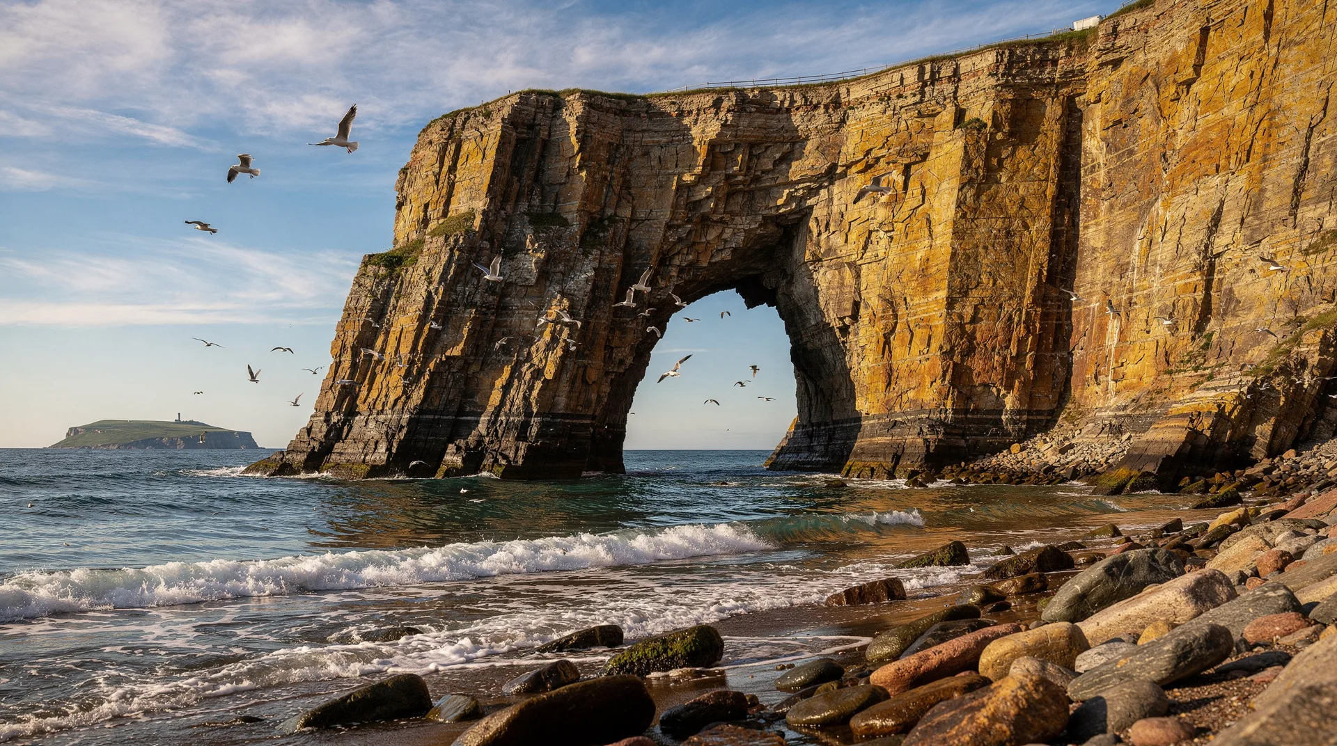
Percé Rock
Percé Rock is approximately 500 metres long, 88 metres tall, and perforated by a natural arch 30 metres high — an arch that is slowly collapsing, the last survivor of four arches that once marked the rock. At low tide, it is possible to walk across the sand bar that connects the rock to the mainland. At high tide, the same passage is covered by 1–2 metres of water.
The rock changes colour through the day as the light angle changes: white-cream in flat light, amber in low sun, orange and pink at sunset. It is most dramatically photographed from the headland viewpoints above the village, from the tour boats that circle it, or from the cape accessible by the trail above Percé village.
Seeing Percé Rock is essentially automatic on any Gaspésie visit — it is impossible to be in Percé without seeing it. But taking time to appreciate it at different times of day, in different light and weather, rewards patience.
Île Bonaventure and Parc national de l’Île-Bonaventure-et-du-Rocher-Percé
Île Bonaventure, reached by a 15-minute boat crossing from Percé, is home to one of the largest northern gannet colonies in the world: approximately 110,000 birds nest on the island’s cliff faces from April through October. The sight — and sound and smell — of 110,000 gannets in breeding activity is overwhelming in the best possible way.
Trails cross the island to the gannet colony on the eastern cliffs. The 4-kilometre walk takes about an hour and a half at a leisurely pace. The gannets nest on every available surface of the cliff face, and the cliff-top trail brings you within metres of the outermost nests. The social behaviour — pairs performing their mutual preening displays, juveniles testing their wings on the cliff edges, the constant commotion of tens of thousands of birds overhead — is one of the most spectacular wildlife experiences in eastern Canada.
The boat operators offer circumnavigation tours as an alternative to or addition to landing: the rock is visible from the water, and gannets are seen diving offshore on the return crossing.
Parc national de la Gaspésie
In the Chic-Choc Mountains at the heart of the peninsula, Parc de la Gaspésie offers some of the finest hiking in eastern Canada. The park’s trail network covers alpine tundra, boreal forest, and river valleys where moose are among the most frequently encountered large mammals in Quebec.
Mont Jacques-Cartier (1,268 m) is the park’s highest summit and requires a day hike of approximately 8 kilometres return. The upper slopes are true arctic-alpine tundra — above the treeline in a region where the rest of Quebec is dominated by forest — and the view from the summit on a clear day extends to the St. Lawrence and, in exceptional conditions, to Prince Edward Island. The caribou of the Gaspésie herd (fewer than 100 individuals, one of Canada’s most vulnerable populations) are sometimes seen on the alpine plateau.
Mont Albert offers a different character: a flat-topped massif with a serpentinite rock geology that produces a unique flora of arctic-alpine species, some found nowhere else in Quebec. The multi-day traverse of the park’s peaks is possible with backcountry camping permits.
Book a Quebec City and St. Lawrence tour from MontrealWhale watching off the northern coast
The northern shore of Gaspésie, particularly around Sainte-Anne-des-Monts and Forillon, receives feeding fin whales, minke whales, and belugas throughout summer. The whale watching here is less intensively organised than at Tadoussac (200 km west) but can be excellent — the quieter boats and less crowded waters sometimes produce better close encounters. Several operators in the northern coast villages offer Zodiac and larger boat tours.
Forillon National Park
At the very tip of the peninsula, before the road reaches Percé, Forillon National Park protects the dramatic headlands and forest of the peninsula’s eastern end. The park’s signature is the Cap-Bon-Ami cliffs — vertical rock faces dropping 200 metres to the Gulf, with breeding black-legged kittiwakes and murres nesting on the ledges.
The Sentier International des Appalaches (the International Appalachian Trail) reaches Forillon as its northern terminus — or, depending on direction, its beginning. Shorter day hikes in the park take in coastal views, seabird activity, and the considerable architectural heritage of the restored fishing families’ homes at Grande-Grave, a national historic site within the park boundaries.
Miguasha National Park
On the south shore of the Baie des Chaleurs, Miguasha’s cliffs contain one of the world’s most important Devonian fossil beds — 380 million years old, preserving the transition between aquatic and terrestrial life in extraordinary detail. The lobe-finned fish preserved here represent direct ancestors of all tetrapods, including humans. UNESCO has designated the site a World Heritage Site.
The interpretation centre manages the paleontological site and offers guided tours of the cliff face where fossils are actively excavated. The experience is well-structured for non-specialist visitors and covers the deep evolutionary significance of what has been found here without losing non-scientific visitors in jargon.
The road trip circuit
The standard circuit begins in Sainte-Flavie where Highway 132 meets the base of the peninsula:
North shore route (heading east): Metis-sur-Mer (Jardins de Métis, one of Canada’s finest public gardens), Sainte-Anne-des-Monts (gateway to Parc de la Gaspésie), Mont-Saint-Pierre (paragliding capital of Quebec), Grande-Vallée.
Through the Chic-Chocs: A day in Parc de la Gaspésie requires a diversion south from the coastal highway. The park entrance at Saint-Anne-des-Monts adds an excellent 60–80 km inland loop.
Peninsula tip: Percé (plan a minimum of two nights for the rock and Île Bonaventure), then Forillon National Park.
South shore return: Gaspé (the actual town, somewhat anticlimactically ordinary after the landscape), Chandler, New Richmond, Carleton-sur-Mer (charming town with a beach and good accommodation), then Matapédia where the Restigouche River marks the New Brunswick border.
When to visit Gaspésie
July and August is peak season. All facilities are open, whale watching boats are operating, and temperatures are warm enough for beach swimming on the south shore (18–22°C in the bay). Accommodation books up in Percé — reservations are essential.
Late September to mid-October is the most visually spectacular period. The Chic-Choc highlands turn brilliant reds and golds, and the coastal maples and birches follow. Temperatures are cool (10–18°C), crowds are thin, and accommodation is easy to find. The whale watching season ends in early October.
June is pleasant but cool, and some facilities are not yet at full operation. The light has a particular clarity and the spring wildflowers are exceptional.
Where to stay
Percé: The main choice for basing the peninsula tip portion of the trip. Hotel Le Mirage and La Normandie are the established properties with direct views of the rock. Multiple smaller gîtes and auberges operate in the village.
Sainte-Anne-des-Monts: For a Parc de la Gaspésie base. Auberge Festive Sea Shack has developed a strong reputation for combining accommodation with outdoor guiding.
Carleton-sur-Mer (south shore): An underrated base with a good beach, a reasonable hotel selection, and a relaxed atmosphere contrasting with the slightly frenetic summer pace of Percé.
Getting to Gaspésie
By car from Quebec City: The most practical approach. Highway 20 east to Rivière-du-Loup, then Highway 132 along the south shore or north shore to the peninsula. From Quebec City to Percé is approximately 6.5–7 hours.
By train: Via Rail operates a Montreal–Gaspé service (the Chaleur), running twice weekly through the Matapédia Valley and along the south shore of the peninsula to Gaspé. The journey is long (18+ hours from Montreal) but passes through remarkable scenery and is itself a worthwhile experience.
By bus: Orléans Express operates bus service from Quebec City to several Gaspésie towns, though connections in the peninsula itself are limited.
Frequently asked questions about Gaspésie
Is a car necessary for Gaspésie? For the road trip experience, yes. The peninsula is large, the attractions are spread along 800 km of coastline and into the interior, and public transport is minimal. A car is effectively required.
How long does the peninsula circuit take? A minimum of 5 days is required to drive the circuit and visit the main highlights. Seven days is more comfortable. Ten days allows in-depth exploration of Parc de la Gaspésie, Forillon, and the south shore.
Can I see moose in Gaspésie? Gaspésie has one of the highest moose densities in Quebec. The interior roads and park areas are excellent for moose, particularly at dawn and dusk. Drive carefully — moose-vehicle collisions are a real risk on rural roads at night.
Is Percé rock accessible year-round? The sand bar to Percé Rock is accessible at low tide year-round (when the tide permits). However, the boat tours to Île Bonaventure operate only April through October.