Quick facts
- Population
- ~300
- Distance from Whitehorse
- 74km south on Hwy 2
- Best time
- June to September
- Days needed
- 1-2 days
- Elevation
- 660m
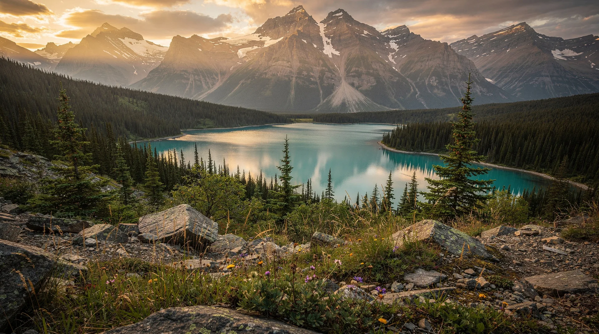
Carcross is a small community of about 300 people in southern Yukon, sitting at the narrows between Bennett Lake and Nares Lake, surrounded by mountains that rise immediately from the shorelines in the way that southern Yukon mountains do — steeply, closely, and with an alpine character that feels more Swiss than subarctic. The name is a contraction of “Caribou Crossing,” a reference to the place where caribou herds once forded the lake narrows during migration.
The community has two compelling claims on visitor attention. The first is the Carcross Desert — a field of sand dunes covering approximately 2.6 square kilometres on the south side of Nares Lake, repeatedly described as the “world’s smallest desert” in a media-friendly superlative that is not quite accurate (it is a glacial deposit, not a true desert) but is nevertheless striking: actual sand dunes of significant scale in the middle of the Yukon mountains, with a character completely unlike the surrounding boreal-alpine landscape.
The second is the Klondike Gold Rush history embedded in the town — Carcross was a key waypoint on the White Pass and Yukon Route railway that carried gold rush stampeders from Skagway through the mountains to the Yukon River and on to Dawson City. The railway’s heritage is still visible in the townsite.
The Carcross Desert
The dunes at Carcross are the remnant of a glacial lake bottom. When the glaciers that filled the region during the last ice age retreated, they left behind fine sand deposits exposed to the prevailing winds that blow down the lake corridors. The surrounding mountains create a rain shadow effect that keeps the dune area relatively dry and prevents the establishment of vegetation that would stabilise the sand.
The result is an anomalous landscape: a field of genuine wind-shaped sand dunes — some reaching 10–30 metres in height — set against a backdrop of lake, boreal forest, and alpine ridgelines. The dunes have enough character to reward an hour of exploration. Sandboarding is possible and practiced — a sand disc rented in Carcross provides enough speed on the steeper faces.
The dunes are accessible on foot from the Carcross townsite — a short walk across the railway tracks and through the scrubby vegetation at the dune margins. No admission fee; no formal entrance. The best light for photography is morning and evening, when the low sun angle creates strong shadow definition in the dune faces.
Carcross Commons and the mountain bike network
Carcross Commons is an Indigenous-owned outdoor recreation development on the mountain slopes above the community — an infrastructure project that has been genuinely praised in the mountain biking world as an example of well-designed trail building in dramatic terrain. The network covers several hundred kilometres of trail on Montana Mountain, with routes ranging from introductory cross-country to serious technical descents.
The collaboration between the Carcross/Tagish First Nation and the mountain biking community that built the trails is cited as a model for recreation development on Indigenous-managed land. Revenue from trail fees and visitor spending returns to the First Nation while creating a recreational destination that draws visitors from across North America.
For hikers, the same trail network provides access to Montana Mountain’s upper slopes and the alpine environment above treeline — wildflower meadows in July, panoramic views of the lake system below, and the kind of big-sky subarctic scenery that Yukon delivers consistently at elevation.
Access: Trailhead at Carcross Commons beside the townsite; trail maps available at the trailhead kiosk and online.
Cost: A trail fee applies for the bike network; check the Carcross Commons website for current rates. Hiking access is generally free on the main trails.
Book guided Yukon day trips and outdoor adventures including southern Yukon destinationsGold Rush and White Pass Railway history
Carcross was a crucial node on the Klondike Gold Rush route. When the White Pass and Yukon Route railway was completed in 1900, it ran from the Alaska Panhandle port of Skagway through the mountains to Carcross and on to Whitehorse, replacing the brutal overland passes that stampeders had walked with their tons of required supplies. The railway transformed the gold rush from a walk of suffering into a manageable journey, and Carcross became a layover and resupply point.
The Duchess, a narrow-gauge steam locomotive displayed in the Carcross townsite, is a preserved example of the equipment that ran the White Pass route. The Matthew Watson General Store (1910) is one of the oldest operating stores in Canada — a log building that has served the community continuously for over a century. The Caribou Hotel (1898), rebuilt several times since its gold rush founding, claims to be the oldest operating hotel in Canada.
Walking through Carcross’s small historic downtown with this context is a different experience from approaching it as a generic small town. The physical scale — a few blocks of wooden buildings on a lakefront — has barely changed in a century, and the continuity is palpable.
Bennett Lake and the southern lakes country
Carcross sits at the northern end of Bennett Lake — a long, deep glacial lake that was the final staging point for gold rush stampeders who had crossed the Chilkoot or White Pass. In the summer of 1898, an estimated 10,000 people camped on the shores of Lake Bennett, waiting for the ice to break up so they could float down the lake system to the Yukon River and on to Dawson City. The community of Bennett at the lake’s southern end has a well-preserved church from this era; it is accessible by White Pass and Yukon Route excursion train from Skagway in summer.
The lake itself is striking — surrounded by mountains, clear, and prone to the violent storms that wrecked many gold rush boats. Paddling Bennett Lake in a modern kayak, with the knowledge of what this water witnessed in 1898, has a specific historical resonance.
The Tagish Road and Six Mile River
The Tagish Road south of Carcross passes through lake country where the Six Mile River connects the southern lakes to Tagish Lake. This is one of the Yukon’s better canoe routes for intermediate paddlers — the current is manageable, the scenery is excellent, and the route has genuine gold rush history (the North-West Mounted Police maintained a post at Tagish to register prospectors).
Practical visit information
Getting there from Whitehorse: 74 kilometres south on the South Klondike Highway (Hwy 2), fully paved, approximately 50 minutes. The drive through the Carcross Corridor — a narrow mountain valley with lakes on both sides and peaks rising directly from the water — is one of the most scenic drives in the Yukon.
Accommodation: Limited in Carcross itself. Most visitors stay in Whitehorse and do Carcross as a day trip. There is a small campground at Carcross; Montana Creek and Spirit Lake in the surrounding area provide additional camping.
Eating: The Caribou Hotel Bistro serves good food in a historic building. The Dune Buggy Food Truck (summer, near the Commons) is a pleasant stop after hiking.
Combined with Skagway/Alaska: The Klondike Highway continues south from Carcross to the US border and on to Skagway, Alaska — a 100-kilometre drive through spectacular scenery. The White Pass and Yukon Route train between Skagway and Carcross runs in summer, providing a return option that avoids back-tracking on the same road.
Browse Yukon tours including White Pass Railway and southern Yukon adventuresRelated destinations and day trips
Carcross is best visited as part of a southern Yukon circuit from Whitehorse. The same road south continues to Skagway, making it easy to pair Carcross with the White Pass and Yukon Route railway. Haines Junction to the west provides access to Kluane National Park. The 7-day Yukon itinerary includes Carcross as a day stop on the Whitehorse–Dawson City circuit. For a wider northern picture, Dawson City and the gold rush history guide provide the Klondike context that Carcross’s railway heritage connects to.
Frequently asked questions about Carcross Yukon: World’s Smallest Desert & Gold Rush
Is the Carcross Desert really a desert? Not by the technical climatic definition — it receives more precipitation than true desert. It is a sand deposit left by glacial outwash that remains unvegetated due to wind and local rain shadow effects. It looks and feels remarkably like a desert, and the experience of walking among genuine dunes in the Yukon mountains is genuinely strange and worth seeking out.
Can I bike the Carcross Commons trails without a guide? Yes — the trail network is well marked and the maps available at the trailhead are sufficient for self-guided exploration. Beginner and intermediate trails are clearly signed. More technical descents are also self-guided but suit experienced riders only. Bike rental is available in Carcross.
Is it worth stopping in Carcross on the way to Skagway? Absolutely — the drive between Whitehorse and Skagway passes through Carcross, and breaking the journey here for 2–3 hours adds the desert, the historic townsite, and the mountain views for minimal extra time. The Klondike Highway through the Carcross Corridor to the US border is one of the most scenic roads in the Yukon regardless of the stop.
What is the best time of year to visit? Summer (June–September) for hiking, mountain biking, and lake access. The autumn colour in September — dwarf birch turning golden on Montana Mountain above the community — is spectacular. Winter is quiet but the sand dunes remain accessible and have an atmospheric desolation in snow.