Quick facts
- Size
- 19,089 km²
- Access
- Via Pangnirtung or Qikiqtarjuaq; no road access
- Permit
- Parks Canada registration mandatory; bear protection required
- Best time
- July to mid-August
- Days needed
- 5-12 days for Akshayuk Pass traverse
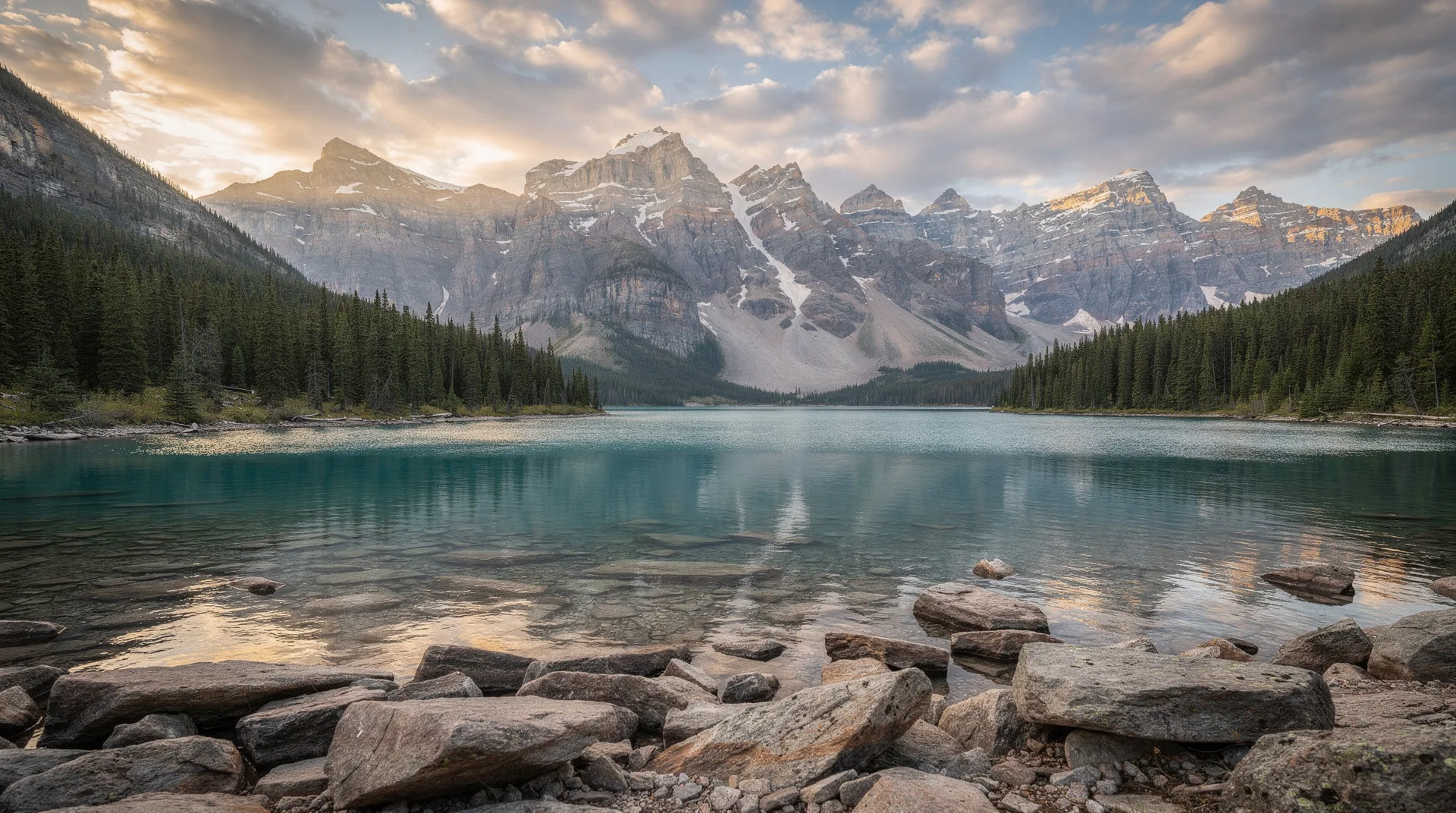
Auyuittuq — the name means “Land that never melts” in Inuktitut — is the most visited national park in Nunavut, which is a relative distinction: the park receives fewer than 500 visitors per year. It covers 19,089 square kilometres on the Cumberland Peninsula of Baffin Island, centred on the Penny Ice Cap and the dramatic valleys and passes that descend from it to the coast. The park is defined by a single geographical feature above all others: the Akshayuk Pass, a 97-kilometre route through the heart of the Cumberland Peninsula that passes beneath some of the most dramatic mountain walls in North America.
Visiting Auyuittuq is not casual wilderness travel. The park has no roads, no trails in the conventional sense (route-finding on glacial outwash and tundra is the standard mode of travel), no emergency infrastructure within the backcountry, and weather that can deteriorate from excellent to dangerous within hours. Parks Canada requires all visitors to register before entering, to carry bear protection (polar bears are present), and to submit a detailed itinerary. Rescue in Auyuittuq is measured in hours or days — clear communication of your plan and strict adherence to it is part of what makes backcountry travel here safe.
For the visitors who do make the commitment, Auyuittuq delivers a scale and drama of mountain wilderness matched in Canada only by the most remote corners of the Yukon and British Columbia.
The Akshayuk Pass
The Akshayuk Pass (formerly known as Pangnirtung Pass) bisects the Cumberland Peninsula from south to north. The standard through-route runs 97 kilometres between the community of Pangnirtung on the southern end and the smaller community of Qikiqtarjuaq on Baffin Bay to the north. Most parties arrange transportation at both ends and travel in one direction over 5–10 days depending on fitness and conditions.
The pass follows the Weasel River from the south and the Owl River from the north. For most of its length, the valley floor is a broad, flat outwash plain — gravel, boulders, and braided river channels deposited by the glaciers that carved the valley over thousands of years. On both sides, granite walls rise 1,200 to 1,800 metres above the valley floor, vertical in places, with glaciers pressing down from the Penny Ice Cap and tributary ice streams descending nearly to the valley floor.
The river crossings
The Weasel River must be crossed multiple times during the south-to-north traverse — anywhere from 6 to 15 crossings depending on conditions and the route chosen. In July at peak snowmelt, these crossings can be thigh-deep, fast-flowing, and extremely cold (1–2°C). The technique — unlinking pack hipbelts, crossing in groups with poles, choosing wide braided sections over narrow swift channels — is taught in technical wilderness travel courses and practiced in advance, not improvised on arrival.
Early July crossings are the most challenging due to snowmelt volume. Late July and August typically have lower, more manageable water levels. Late August can see early fall snowfall that re-raises water levels in cold nights.
Thor Peak: the world’s greatest vertical drop
Thor Peak, at the head of the Weasel Valley approximately halfway along the pass route, rises to 1,675 metres. Its north face drops a nearly vertical 1,250 metres to the glacier below — the greatest vertical drop on any mountain face in the world. The scale of the wall is difficult to comprehend at valley level; photographs consistently fail to convey the impression of standing in the valley with 1,000 metres of near-vertical granite directly above you.
Rock climbers have mounted expeditions to Thor Peak’s face since the 1970s, but the climbing is extreme technical mountaineering beyond the reach of general visitors. For trekkers, the view of the face from the valley is the experience — position yourself with binoculars on the western valley slopes for the perspective that best captures the wall’s full height.
Overlord peak and the surrounding walls
Thor Peak is the most famous, but the entire Akshayuk corridor is lined with significant faces. Overlord (1,788 metres) towers above the Caribou Glacier at the valley’s heart; Asgard (2,015 metres), visible from the pass, is a double-summited peak whose twin cylindrical towers have appeared in climbing fiction and adventure advertising. The pass is surrounded by world-class mountain terrain that most hikers pass through rather than climb — a scale of wilderness scenery delivered to people wearing hiking boots rather than climbing harnesses.
Browse Canada Arctic expedition and adventure travel experiencesDay hiking from Pangnirtung
For visitors without the time or wilderness experience for the full pass traverse, day hiking from the Pangnirtung end of the pass provides significant scenery with a manageable logistical commitment.
The Parks Canada field office in Pangnirtung can provide guidance on current conditions and register you for a day trip into the park. The first 5–10 kilometres of the pass from the Pangnirtung end deliver glacier views, dramatic valley walls, and the transition from Arctic coastal landscape to deep mountain terrain. A full day hike from town to the park boundary and a few kilometres into the valley provides genuinely impressive scenery without requiring overnight backcountry commitment.
Note that even day hikers must register with Parks Canada. This is not bureaucratic formality — it is a safety system that ensures someone knows where you are.
Polar bears in Auyuittuq
Polar bears are present throughout the park, particularly in coastal areas near Pangnirtung Fjord and in the Qikiqtarjuaq area. In the pass interior during summer, bears are less common but not absent — they follow the Weasel River corridor at times, particularly during low-snow periods when food sources concentrate along the valley bottom.
Parks Canada requires all overnight visitors to carry bear protection: a minimum of bear spray, with firearms carried by many experienced backcountry groups. The park’s guidance on bear encounters — making noise, travelling in groups, storing food in bear-resistant containers — should be followed rigorously. Polar bears in the Arctic have different learned associations with humans than grizzly bears in more heavily visited parks; curiosity-based approaches by bears are common and require calm, deliberate response.
Logistics and cost of a visit
Access to Pangnirtung: Fly from Iqaluit (approximately 1 hour, Canadian North scheduled service or charter). Pangnirtung has limited accommodation — the Auyuittuq Lodge and a community guesthouse are the main options. Book months in advance for July–August.
Parks Canada registration: Required for all visitors, online or at the Pangnirtung field office. An entry fee applies (Parks Canada Discovery Pass is valid). Mandatory gear list (bear spray, bear canister) must be confirmed before registration is completed.
Equipment: Full backcountry mountaineering-adjacent kit for multi-day traverse groups — cold-weather sleeping bag (to -10°C minimum), trekking poles, gaiters, waterproof hiking boots capable of wet river crossings, and weather gear for all conditions. July temperatures average 5–15°C in the valley, with wind chill in exposed sections significantly colder.
Guided traverses: Several outfitters based in Pangnirtung or arranging travel through Nunavut Tourism lead guided Akshayuk Pass traverses. Cost for a fully guided 8–10 day traverse: CAD 4,000–7,000 per person. This includes guide, food, equipment coordination, and logistics — a significant sum reflecting the genuine remoteness and the skill required.
Getting to Qikiqtarjuaq (north end): If completing a one-way traverse, you need transportation arrangements from Qikiqtarjuaq back to Iqaluit. Scheduled flights from Qikiqtarjuaq to Iqaluit are available but infrequent — build flexibility into the northern end of your itinerary.
Total trip cost: A 10-day visit including return flights from Ottawa to Iqaluit, Iqaluit to Pangnirtung, accommodation, park fees, and guided traverse: CAD 6,000–10,000 per person. Independent groups reduce this somewhat but not dramatically — the flights remain the dominant cost.
Related destinations
Auyuittuq is accessed through Pangnirtung on Baffin Island — the island guide covers all Baffin communities and connections. Iqaluit is the entry point for all Baffin Island travel. The broader Nunavut guide covers practical planning for the territory. For wildlife context, the narwhal viewing guide and floe edge tours describe the wildlife experiences available from the Baffin communities adjacent to the park.
Frequently asked questions about Auyuittuq National Park: Akshayuk Pass & Thor Peak
What experience level is required for the Akshayuk Pass traverse? Strong wilderness hiking and backcountry camping experience is required at minimum. The river crossings add a technical element that makes simple trail-hiking experience insufficient for most July conditions. Navigate, read terrain, cross moving water, manage multi-day backcountry camping, and operate confidently in a remote environment without rescue expectation. Guided groups make this accessible to strong but less experienced hikers.
Can I see Thor Peak without doing the full traverse? Not easily — Thor Peak is approximately 45–55 kilometres into the pass from the Pangnirtung end. Reaching it and returning to Pangnirtung represents approximately a 4–5 day round trip for fit hikers. There is no flyover access at valley level; flightseeing over the pass from Pangnirtung allows aerial views of the wall and surrounding terrain.
Are there animals other than polar bears in the park? Yes — Arctic wolves travel the pass corridor; Arctic hares are common on the talus slopes; ptarmigan are present on the valley walls; and Arctic foxes are occasional sightings. The Weasel River has Arctic char. The glaciers above the valley support no wildlife, but the valley floor and margins are reasonably active for Arctic fauna.
What happens if the weather turns bad? Build weather days into your itinerary — at least 2 additional days beyond your planned traverse time. Arctic weather can pin you in a valley for 2–3 days without improving; groups that plan for this arrive relaxed and those that don’t arrive desperate. There are no emergency cabins in the park; you are camping in whatever weather arrives.